Articoli simili a Map of Ariège France with Foix and Pyrenees Landscape by Vuillemin, 19th c


Vuoi altre immagini o video?
Richiedi altre immagini o video al venditore
1 di 11
Map of Ariège France with Foix and Pyrenees Landscape by Vuillemin, 19th c
120 €IVA inclusa
Informazioni sull’articolo
Map of Ariège France with Foix and Pyrenees Landscape by Vuillemin, 19th c
Description:
This beautifully detailed 19th-century map of the Ariège department in southwestern France was drawn by the French cartographer Alexandre Vuillemin and published by Migeon in Paris as part of the illustrated Nouvel Atlas Illustré. Rich in visual and historical content, the map offers a fascinating portrait of this mountainous border region adjacent to Spain and Andorra.
The map shows the full expanse of Ariège with clear labeling of towns, rivers, roads, and departmental borders, the latter highlighted in hand-applied yellow watercolor. The department is nestled against the Pyrenees mountain range, with Foix, Saint-Girons, and Pamiers as its major towns. The topographical relief hints at the region's rugged alpine character.
To the lower left is a picturesque vignette of Foix, the departmental capital, with its famous medieval castle perched dramatically on a rocky hill above the town. On the lower right is a view of the southern borderlands facing the Spanish frontier. At the upper right appears a portrait of General Bertrand Clausel, a native of Ariège who served in the Napoleonic Wars and later became governor of Algeria. Beneath him is the coat of arms of the department, with its vertical stripes and laurel branch motif.
Ariège is known for its striking mountain scenery, medieval fortresses, Cathar heritage, and natural thermal springs. Although not widely recognized as a major wine-producing area, it does have a tradition of small-scale viticulture, especially in the foothills, with rustic wines from local grapes. The area is more renowned for sheep cheese (such as tomme and Bethmale), honey, and mountain herbal products. Today, it is popular among hikers, cyclists, and nature lovers for its unspoiled valleys and ancient hilltop villages.
Alexandre Vuillemin was a leading 19th-century French cartographer noted for integrating history, culture, and art into his maps. His works were both educational and decorative, making them highly collectible. The publisher, Migeon, specialized in atlases that appealed to a broad public through refined design and engraving quality.
Condition summary:
Very good condition with light age toning and a few minor foxing marks in the margins. Engraved lines are sharp, and the hand coloring is clean and well preserved.
Framing tips:
This map would look excellent in a walnut or natural wood frame to complement its rustic and mountainous theme. A soft cream or ivory mat will enhance the engraved detail and yellow border. Museum glass is recommended for optimal preservation.
- Dimensioni:Altezza: 26,1 cm (10,28 in)Larghezza: 32,5 cm (12,8 in)Profondità: 0,2 mm (0,01 in)
- Materiali e tecniche:Carta,Inciso
- Luogo di origine:
- Periodo:
- Data di produzione:circa 1850
- Condizioni:Very good condition with light age toning and a few minor foxing marks in the margins. Engraved lines are sharp, and the hand coloring is clean and well preserved.
- Località del venditore:Langweer, NL
- Numero di riferimento:Venditore: BG-13331-81stDibs: LU3054345359562
Informazioni sul venditore
5,0
Venditore riconosciuto
Questi venditori prestigiosi sono leader del settore e rappresentano il massimo in termini di qualità e design.
Venditore Platino
Venditori Premium con valutazione 4.7+ e tempi di risposta entro 24 ore
Fondazione nel 2009
Venditore 1stDibs dal 2017
2533 vendite su 1stDibs
Tempo di risposta standard: <1 ora
- SpedizioneRecupero del preventivo…Spedizione da: Langweer, Paesi Bassi
- Politica di reso
Alcune parti di questa pagina sono state tradotte automaticamente. 1stDibs non può garantire che le traduzioni siano corrette. L’inglese è la lingua predefinita del sito.
Garanzia di autenticità
Nell’improbabile caso in cui si verifichi un problema con l’autenticità di un articolo, contattaci entro un anno per ottenere un rimborso completo. DettagliGaranzia di rimborso
Se il tuo articolo non corrisponde alla descrizione, è danneggiato durante il trasporto o non arriva, contattaci entro 7 giorni per un rimborso completo. DettagliAnnullamento entro 24 ore
Hai un periodo di tolleranza di 24 ore per annullare il tuo acquisto, senza necessità di fornire spiegazioni.Venditori professionali selezionati
I nostri venditori di livello internazionale devono aderire a rigorosi standard di servizio e qualità, garantendo l’integrità delle inserzioni.Garanzia miglior prezzo
Se scopri che un venditore ha pubblicato altrove lo stesso articolo a un prezzo più basso, applicheremo lo stesso prezzo.Consegna globale affidabile
La nostra rete di vettori leader del settore offre opzioni di spedizione specializzate in tutto il mondo, inclusa la consegna personalizzata.Altro da questo venditore
Mostra tuttoMap of Ardèche France with Annonay and Vineyards by Vuillemin, 19th c
Map of Ardèche France with Annonay and Vineyards by Vuillemin, 19th c
This beautifully engraved 19th-century map of Ardèche, a department in southeastern France, comes from Alexandr...
Categoria
Di antiquariato/d’epoca, Metà XIX secolo, Francese, Mappe
Materiali
Carta

Map of Côtes-du-Nord France with Saint-Brieuc and Brittany Coastline, c.1850
Map of Côtes-du-Nord France with Saint-Brieuc and Brittany Coastline, 19th c
Description:
This elegant 19th-century map of Côtes-du-Nord, the historic name for what is now known as ...
Categoria
Di antiquariato/d’epoca, Metà XIX secolo, Francese, Mappe
Materiali
Carta

Map of Allier France with Saint-Pourçain Wine Region by Vuillemin, 19th c
Map of Allier France with Saint-Pourçain Wine Region by Vuillemin, 19th c
This decorative 19th-century map of Allier, a central department of France, comes from the celebrated Nouve...
Categoria
Di antiquariato/d’epoca, Metà XIX secolo, Francese, Mappe
Materiali
Carta

Map of Aude France with Carcassonne and Languedoc Vineyards, 19th Century
Map of Aude France with Carcassonne and Languedoc Vineyards, 19th Century
Description:
This elegant 19th-century map of Aude, a department in southern France along the Mediterranean...
Categoria
Di antiquariato/d’epoca, Metà XIX secolo, Francese, Mappe
Materiali
Carta

Map of Aisne France with Soissons and Champagne Vineyards by Vuillemin, 19th c
Map of Aisne France with Soissons and Champagne Vineyards by Vuillemin, 19th c
Description:
This richly detailed 19th-century engraved and hand-colored map of the department of Aisn...
Categoria
Di antiquariato/d’epoca, Metà XIX secolo, Francese, Mappe
Materiali
Carta

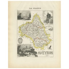
Map of Aveyron France with Rodez, Millau and Wine Routes, 19th Century
Map of Aveyron France with Rodez, Millau and Wine Routes, 19th Century
Description:
This detailed and decorative 19th-century map of Aveyron, a department in southern France, was dr...
Categoria
Di antiquariato/d’epoca, Metà XIX secolo, Francese, Mappe
Materiali
Carta
Ti potrebbe interessare anche
Lozere, Francia. Mappa antica di un dipartimento francese, 1856
Di Victor Levasseur
'Dept. de La Lozere', incisione in acciaio con colorazione a mano dei contorni originali, 1856, da 'Atlas National Illustre' di Levasseur.
Questa remota zona montuosa della Linguad...
Categoria
XIX secolo, Naturalismo, Stampe (paesaggio)
Materiali
Incisione

L'Isere, Francia. Mappa antica del dipartimento francese, 1856
Di Victor Levasseur
'Dept. de L'Isere', incisione in acciaio con colorazione a mano dei contorni originali, 1856, da 'Atlas National Illustre' di Levasseur.
Questa zona è nota per la produzione del Bl...
Categoria
XIX secolo, Naturalismo, Stampe (paesaggio)
Materiali
Incisione

Pirenei Orientali, Francia. Mappa antica di un dipartimento francese, 1856
Di Victor Levasseur
'Dept. des Pyrenees Orientales', incisione in acciaio con colorazione a mano dei contorni originali, 1856, da 'Atlas National Illustre' di Levasseur.
Quest'area è una nota regione ...
Categoria
XIX secolo, Naturalismo, Stampe (paesaggio)
Materiali
Incisione

Aude, Francia. Mappa antica di un dipartimento francese, 1856
Di Victor Levasseur
'Dept. de L' Aude', incisione in acciaio con colorazione a mano dei contorni originali, 1856, da 'Atlas National Illustre' di Levasseur.
Questa zona della Francia è famosa per l'am...
Categoria
XIX secolo, Naturalismo, Stampe (paesaggio)
Materiali
Incisione

Aube, Francia. Mappa antica di un dipartimento francese, 1856
Di Victor Levasseur
'Dept. de L'Aube', incisione in acciaio con colorazione a mano dei contorni originali, 1856, da 'Atlas National Illustre' di Levasseur.
Questa zona della Francia è nota per la prod...
Categoria
XIX secolo, Naturalismo, Stampe (paesaggio)
Materiali
Incisione

Hautes Alpes, Francia. Mappa antica di un dipartimento francese, 1856
Di Victor Levasseur
Dept. des Hautes Alpes", incisione in acciaio con colorazione a mano dei contorni originali, 1856, da "Atlas National Illustre" di Levasseur.
Questa zona della Francia è nota per l...
Categoria
XIX secolo, Naturalismo, Stampe (paesaggio)
Materiali
Incisione
