Articoli simili a Map of Bouches-du-Rhône France with Marseille and Rhône Delta, 19th Century


Vuoi altre immagini o video?
Richiedi altre immagini o video al venditore
1 di 10
Map of Bouches-du-Rhône France with Marseille and Rhône Delta, 19th Century
120 €IVA inclusa
Informazioni sull’articolo
Map of Bouches-du-Rhône France with Marseille and Rhône Delta, 19th Century
Description:
This finely engraved 19th-century map of the Bouches-du-Rhône department in southeastern France showcases one of the country’s most iconic Mediterranean regions. Published by Migeon in Paris and drawn for the *Nouvel Atlas Illustré*, this map combines cartographic precision with decorative vignettes that highlight the area’s economic, cultural, and geographic importance.
Hand-colored in soft coral tones, the map delineates towns, roads, and rivers, with Marseille clearly marked in bold red as the departmental capital and historic port city. The Rhône River is shown dividing into its two branches before entering the Mediterranean Sea, forming the wide Rhône delta known as the Camargue—a region famous for its wild horses, flamingos, and salt marshes.
To the upper left are portraits of three prominent historical figures associated with the region: statesmen and naval leaders whose contributions are tied to Marseille's military and maritime past. At the top right, a detailed engraving captures the bustling port of Marseille, with ships at dock and fortifications along the shoreline, emphasizing its long-standing role as a hub of commerce and culture.
Bouches-du-Rhône is also a celebrated wine region and a key part of Provence’s viticultural identity. The vineyards around Aix-en-Provence and the coastal areas near Cassis produce excellent rosé and white wines under designations such as Coteaux d’Aix-en-Provence and Cassis AOC. The area's dry, sunny climate and limestone soils contribute to the elegance and minerality of its wines. Alongside wine, olive oil, lavender, and seafood have long shaped the local economy and Provençal cuisine.
This map reflects both the strategic and agricultural richness of the region, balancing the classical beauty of antique engraving with informative geographic detail. It is ideal for collectors with an interest in maritime history, Mediterranean culture, or wine-producing regions.
Condition summary:
Very good condition with light age toning and faint foxing mainly around the edges. The engraved lines are clear and sharp, and the original hand coloring is well preserved.
Framing tips:
Pair this map with a coastal or nautical-themed frame, such as driftwood or natural oak. A cream or stone-colored mat will complement the soft red coloring. UV-protective glass is recommended for preservation.
- Dimensioni:Altezza: 26,1 cm (10,28 in)Larghezza: 32,5 cm (12,8 in)Profondità: 0,2 mm (0,01 in)
- Materiali e tecniche:Carta,Inciso
- Luogo di origine:
- Periodo:
- Data di produzione:circa 1850
- Condizioni:Very good condition with light age toning and faint foxing mainly around the edges. The engraved lines are clear and sharp, and the original hand coloring is well preserved.
- Località del venditore:Langweer, NL
- Numero di riferimento:Venditore: BG-13331-121stDibs: LU3054345359752
Informazioni sul venditore
5,0
Venditore riconosciuto
Questi venditori prestigiosi sono leader del settore e rappresentano il massimo in termini di qualità e design.
Venditore Platino
Venditori Premium con valutazione 4.7+ e tempi di risposta entro 24 ore
Fondazione nel 2009
Venditore 1stDibs dal 2017
2567 vendite su 1stDibs
Tempo di risposta standard: <1 ora
- SpedizioneRecupero del preventivo…Spedizione da: Langweer, Paesi Bassi
- Politica di reso
Alcune parti di questa pagina sono state tradotte automaticamente. 1stDibs non può garantire che le traduzioni siano corrette. L’inglese è la lingua predefinita del sito.
Garanzia di autenticità
Nell’improbabile caso in cui si verifichi un problema con l’autenticità di un articolo, contattaci entro un anno per ottenere un rimborso completo. DettagliGaranzia di rimborso
Se il tuo articolo non corrisponde alla descrizione, è danneggiato durante il trasporto o non arriva, contattaci entro 7 giorni per un rimborso completo. DettagliAnnullamento entro 24 ore
Hai un periodo di tolleranza di 24 ore per annullare il tuo acquisto, senza necessità di fornire spiegazioni.Venditori professionali selezionati
I nostri venditori di livello internazionale devono aderire a rigorosi standard di servizio e qualità, garantendo l’integrità delle inserzioni.Garanzia miglior prezzo
Se scopri che un venditore ha pubblicato altrove lo stesso articolo a un prezzo più basso, applicheremo lo stesso prezzo.Consegna globale affidabile
La nostra rete di vettori leader del settore offre opzioni di spedizione specializzate in tutto il mondo, inclusa la consegna personalizzata.Altro da questo venditore
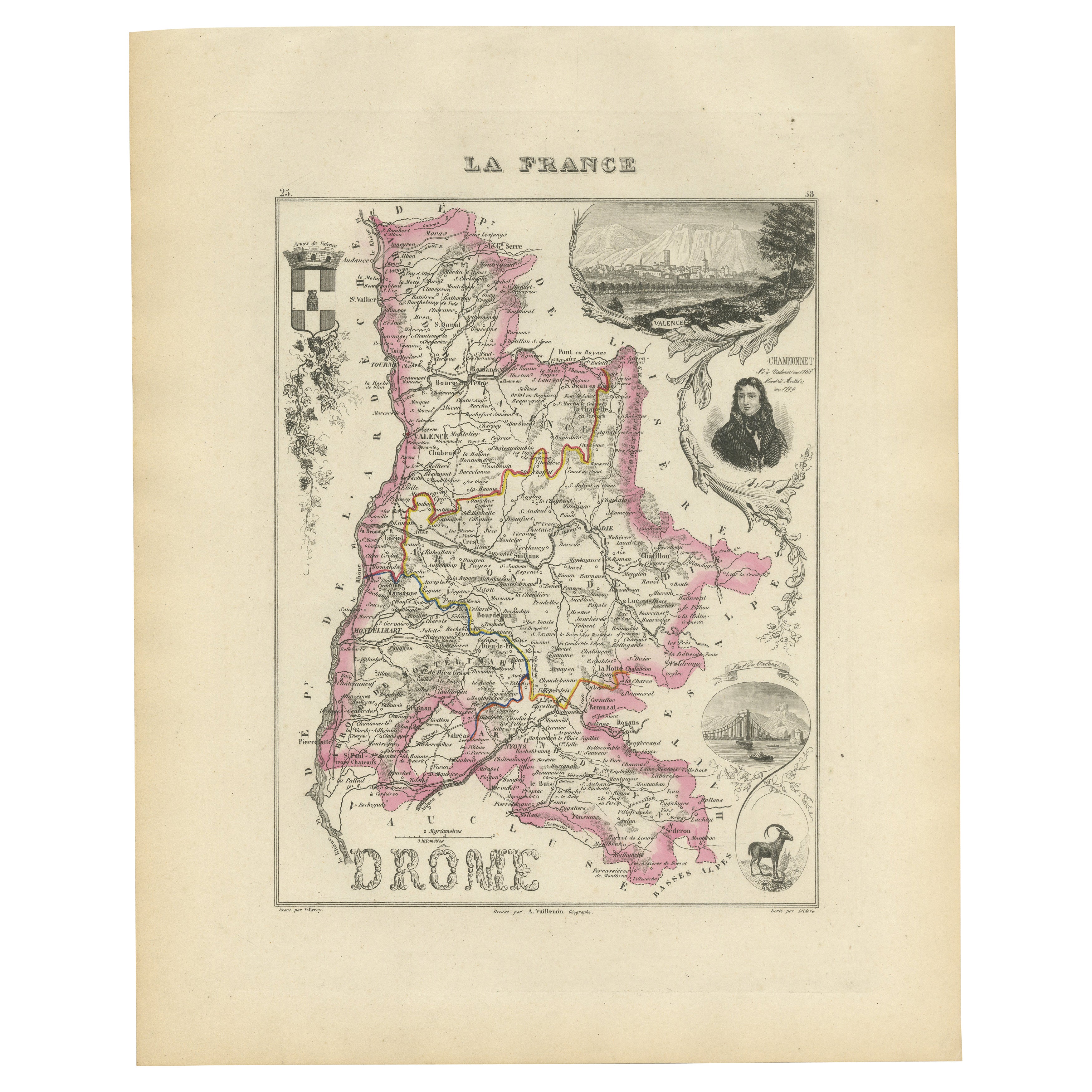
Mostra tuttoMap of Drôme France with Valence and Rhône Valley Wine Region, 19th Century
Map of Drôme France with Valence and Rhône Valley Wine Region, 19th Century
Description:
This beautifully engraved 19th-century map of the Drôme department in southeastern France wa...
Categoria
Di antiquariato/d’epoca, Metà XIX secolo, Francese, Mappe
Materiali
Carta
Map of Aude France with Carcassonne and Languedoc Vineyards, 19th Century
Map of Aude France with Carcassonne and Languedoc Vineyards, 19th Century
Description:
This elegant 19th-century map of Aude, a department in southern France along the Mediterranean...
Categoria
Di antiquariato/d’epoca, Metà XIX secolo, Francese, Mappe
Materiali
Carta

Map of Ardèche France with Annonay and Vineyards by Vuillemin, 19th c
Map of Ardèche France with Annonay and Vineyards by Vuillemin, 19th c
This beautifully engraved 19th-century map of Ardèche, a department in southeastern France, comes from Alexandr...
Categoria
Di antiquariato/d’epoca, Metà XIX secolo, Francese, Mappe
Materiali
Carta

Carta geografica antica della Francia, 1903, con inserto di Parigi e della Corsica
Titolo: Carta geografica antica della Francia, 1903, con inserto di Parigi e Corsica
Descrizione:
Questa mappa antica, intitolata "Francia", è stata incisa e pubblicata nel 1903 dal...
Categoria
Inizio XX secolo, Mappe
Materiali
Carta

Map of Côtes-du-Nord France with Saint-Brieuc and Brittany Coastline, c.1850
Map of Côtes-du-Nord France with Saint-Brieuc and Brittany Coastline, 19th c
Description:
This elegant 19th-century map of Côtes-du-Nord, the historic name for what is now known as ...
Categoria
Di antiquariato/d’epoca, Metà XIX secolo, Francese, Mappe
Materiali
Carta

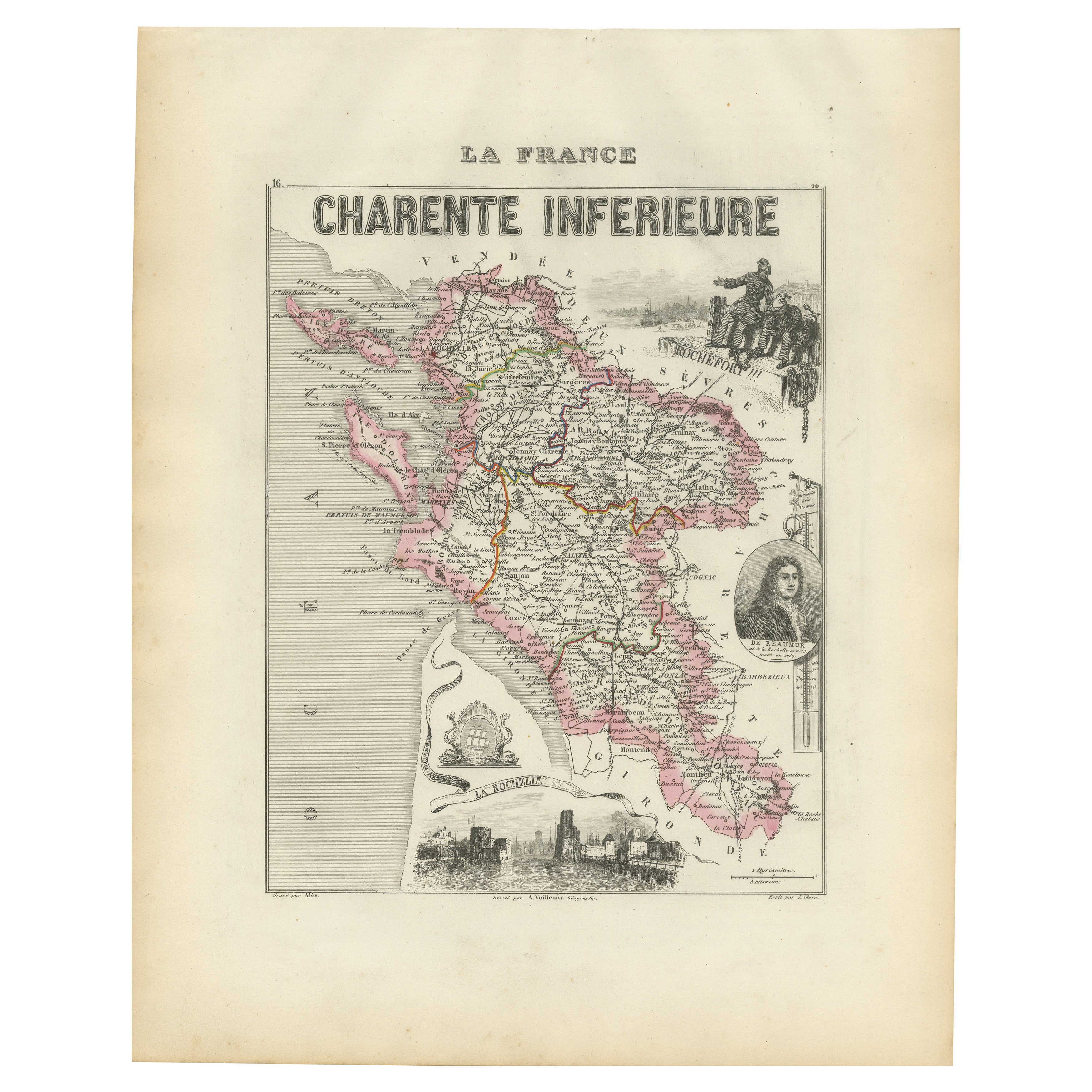
Map of Charente-Inférieure France with La Rochelle and Coastal Vineyards, c.1850
Map of Charente-Inférieure France with La Rochelle and Coastal Vineyards, 19th c
Description:
This decorative 19th-century map of the former department of Charente-Inférieure, now k...
Categoria
Di antiquariato/d’epoca, Metà XIX secolo, Francese, Mappe
Materiali
Carta
Ti potrebbe interessare anche
Mappa del Rodano - Incisione originale - XIX secolo
La mappa del Rodano è un'antica incisione originale realizzata da un incisore anonimo del XIX secolo.
Stampato in serie "France Pittoresque" in alto al centro.
Lo stato di conserva...
Categoria
XIX secolo, Moderno, Stampe figurative
Materiali
Acquaforte

Grande mappa della Francia del XIX secolo
Grande mappa della Francia del XIX secolo.
Condizioni notevoli, con una piacevole patina di usura.
Incorniciato di recente.
Francia, circa 1874.
Categoria
Di antiquariato/d’epoca, Fine XIX secolo, Francese, Mappe
Materiali
Lino, Carta

Mappa della Vandea - Acquaforte - XIX secolo
La Mappa della Vandea è un'incisione realizzata da un incisore anonimo del XIX secolo.
Stampato in serie "France Pittoresque" in alto al centro.
Lo stato di conservazione dell'oper...
Categoria
XIX secolo, Moderno, Stampe figurative
Materiali
Acquaforte

Mappa dell'Alta Vienne - Litografia originale - XIX secolo
La Mappa dell'Alta Vienne è un'opera d'arte originale in litografia realizzata da un Incisore anonimo del XIX secolo.
Stampato nella serie di "France Pittoresque".
Intitolato "Fr...
Categoria
XIX secolo, Moderno, Stampe figurative
Materiali
Litografia

L'Herault, Francia. Mappa antica di un dipartimento francese, 1856
Di Victor Levasseur
'Dept. de Saone et Loire', incisione in acciaio con colorazione a mano dei contorni originali, 1856, dall'Atlas National Illustre di Levasseur.
Quest'area ospita un'ampia varietà d...
Categoria
XIX secolo, Naturalismo, Stampe (paesaggio)
Materiali
Incisione

Mappa di Deux Sèvres - Incisione originale - XIX secolo
La Mappa di Deux Sèvres è un'incisione antica originale realizzata da un incisore anonimo del XIX secolo.
Stampato in serie "France Pittoresque" in alto al centro.
Lo stato di cons...
Categoria
XIX secolo, Moderno, Stampe figurative
Materiali
Acquaforte
