Articoli simili a Map of Corsica France with Ajaccio and Napoleon Portraits, 19th Century

Vuoi altre immagini o video?
Richiedi altre immagini o video al venditore
1 di 10
Map of Corsica France with Ajaccio and Napoleon Portraits, 19th Century
140 €IVA inclusa
Informazioni sull’articolo
Map of Corsica France with Ajaccio and Napoleon Portraits, 19th Century
Description:
This finely engraved 19th-century map of Corsica, the Mediterranean island region of France, was created by Alexandre Vuillemin and published by Migeon in Paris for the *Nouvel Atlas Illustré*. Combining topographic clarity with historical reverence, this map presents Corsica in its full mountainous grandeur, surrounded by finely rendered vignettes that pay tribute to its most famous native—Napoleon Bonaparte.
The map displays the entire island with detailed roads, towns, and natural features, bordered in hand-applied pink watercolor. Ajaccio, the capital and birthplace of Napoleon, is prominently marked on the western coast. Other key towns such as Bastia, Corte, Sartène, and Bonifacio are shown with accuracy, as are the island’s rivers and rugged terrain.
At the top left, a panoramic engraving of Ajaccio is set against a mountainous backdrop, giving visual weight to Corsica’s dramatic landscapes and coastal towns. In the lower corners, two full-length portraits of Napoleon frame the map: one of him as a young military officer, and the other as emperor in coronation robes. These images honor Corsica’s most legendary figure and symbolize the island’s lasting influence on French and European history.
Corsica is known for its fierce regional identity, natural beauty, and distinct cultural heritage. While not a major wine-exporting island in the 19th century, Corsica has long produced wines from native grapes such as Nielluccio, Sciacarello, and Vermentino. Its wine culture has grown substantially over time, now celebrated for producing robust reds and aromatic whites with Mediterranean character. In the 1800s, Corsica was also known for olive oil, citrus, and chestnut production, much of it cultivated on terraced hillsides and in rural villages.
This map is a fitting tribute to the rugged independence and historical richness of Corsica. Its blend of political geography, maritime setting, and symbolic portraiture makes it a standout piece in any collection of antique French maps or Napoleonic memorabilia.
Condition summary:
Very good condition with light age-related toning and a few small foxing marks in the outer margins. Original hand coloring is clean and the engraving remains crisp and detailed.
Framing tips:
Best framed in a dark wood or empire-style frame to echo the Napoleonic theme. A soft ivory or light tan mat will complement the pink border and vignette engravings. Museum glass is recommended for long-term preservation and clarity.
- Dimensioni:Altezza: 32,5 cm (12,8 in)Larghezza: 26,1 cm (10,28 in)Profondità: 0,2 mm (0,01 in)
- Materiali e tecniche:Carta,Inciso
- Luogo di origine:
- Periodo:
- Data di produzione:circa 1850
- Condizioni:Very good condition with light age-related toning and a few small foxing marks in the outer margins. Original hand coloring is clean and the engraving remains crisp and detailed.
- Località del venditore:Langweer, NL
- Numero di riferimento:Venditore: BG-13331-191stDibs: LU3054345363622
Informazioni sul venditore
5,0
Venditore riconosciuto
Questi venditori prestigiosi sono leader del settore e rappresentano il massimo in termini di qualità e design.
Venditore Platino
Venditori Premium con valutazione 4.7+ e tempi di risposta entro 24 ore
Fondazione nel 2009
Venditore 1stDibs dal 2017
2528 vendite su 1stDibs
Tempo di risposta standard: <1 ora
- SpedizioneRecupero del preventivo…Spedizione da: Langweer, Paesi Bassi
- Politica di reso
Alcune parti di questa pagina sono state tradotte automaticamente. 1stDibs non può garantire che le traduzioni siano corrette. L’inglese è la lingua predefinita del sito.
Garanzia di autenticità
Nell’improbabile caso in cui si verifichi un problema con l’autenticità di un articolo, contattaci entro un anno per ottenere un rimborso completo. DettagliGaranzia di rimborso
Se il tuo articolo non corrisponde alla descrizione, è danneggiato durante il trasporto o non arriva, contattaci entro 7 giorni per un rimborso completo. DettagliAnnullamento entro 24 ore
Hai un periodo di tolleranza di 24 ore per annullare il tuo acquisto, senza necessità di fornire spiegazioni.Venditori professionali selezionati
I nostri venditori di livello internazionale devono aderire a rigorosi standard di servizio e qualità, garantendo l’integrità delle inserzioni.Garanzia miglior prezzo
Se scopri che un venditore ha pubblicato altrove lo stesso articolo a un prezzo più basso, applicheremo lo stesso prezzo.Consegna globale affidabile
La nostra rete di vettori leader del settore offre opzioni di spedizione specializzate in tutto il mondo, inclusa la consegna personalizzata.Altro da questo venditore
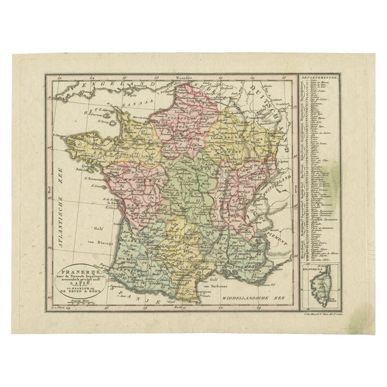
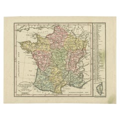
Mostra tuttoCarta geografica antica della Francia con inserto dell'isola di Corsica, 1820 ca.
Carta geografica antica intitolata "Frankrijk naar de nieuwste bepalingen meerendeels gevolgd naar Lapie". Bellissima mappa della Francia con un inserto dell'isola di Corsica. Includ...
Categoria
Di antiquariato/d’epoca, XIX secolo, Olandese, Mappe
Materiali
Carta
144 € Prezzo promozionale
20% in meno
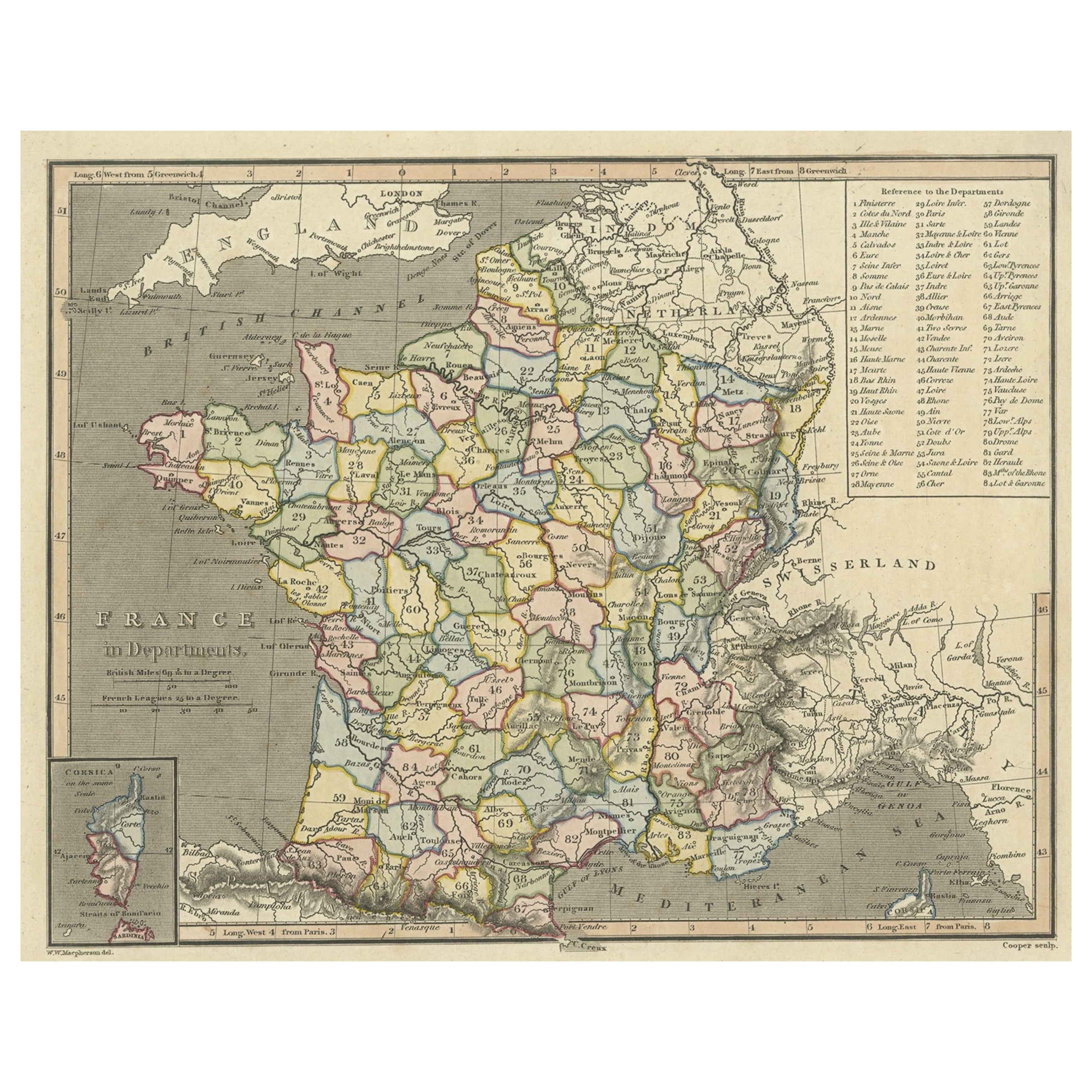
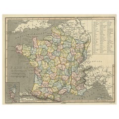
Carta geografica antica della Francia con inserto dell'isola di Corsica, 1820
Carta geografica antica intitolata "Francia in Dipartimenti". Carta geografica antica della Francia, con piccolo inserto dell'isola di Corsica. Include una tabella con i riferimenti ...
Categoria
Di antiquariato/d’epoca, XIX secolo, Mappe
Materiali
Carta
208 € Prezzo promozionale
20% in meno
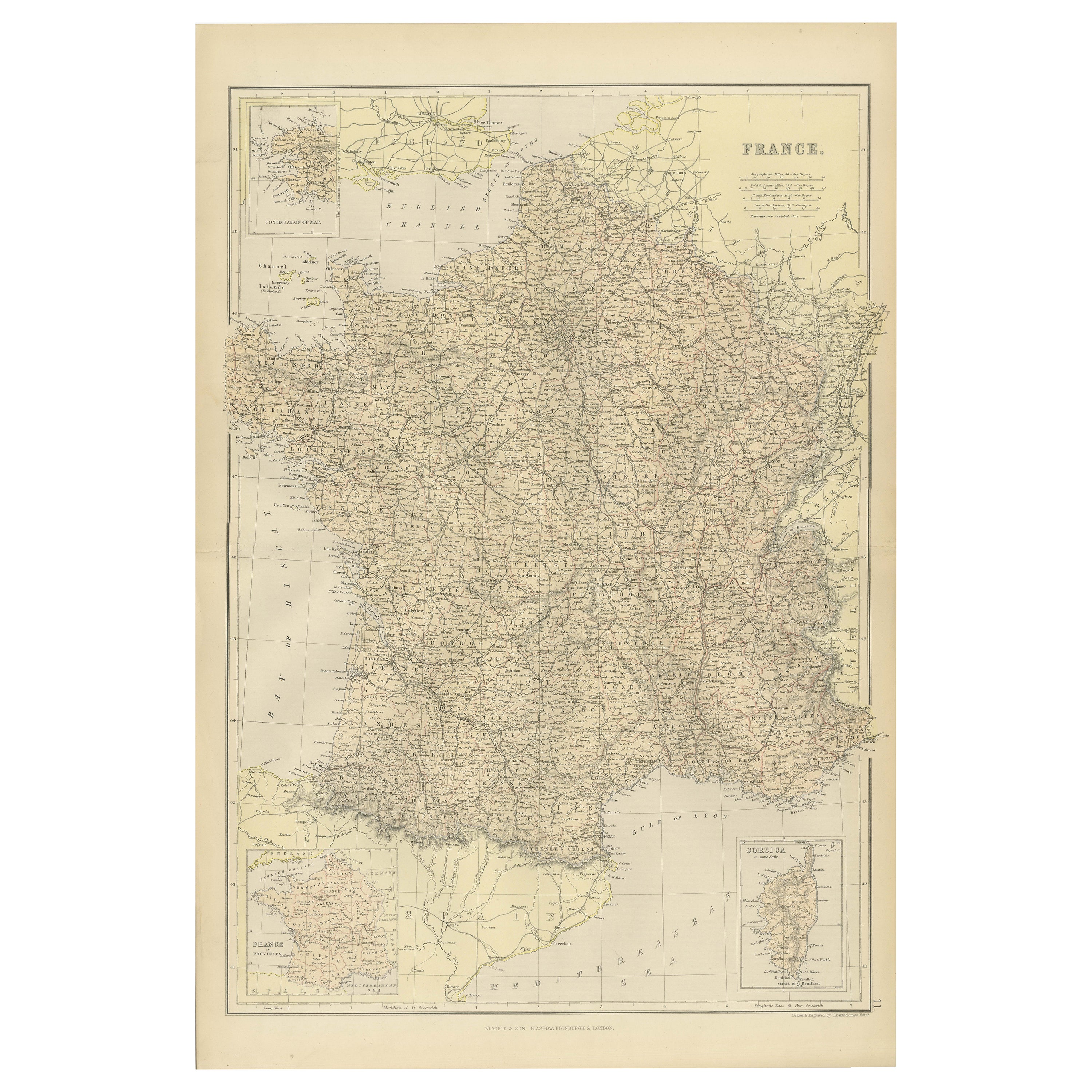
Mappa della Francia del 1882 che evidenzia i confini politici, le città e gli inserti della Corsica
Questa mappa della Francia del 1882, pubblicata da Blackie and Son come parte del "Comprehensive Atlas and Geography of the World", offre una rappresentazione dettagliata del paese a...
Categoria
Di antiquariato/d’epoca, Anni 1880, Mappe
Materiali
Carta

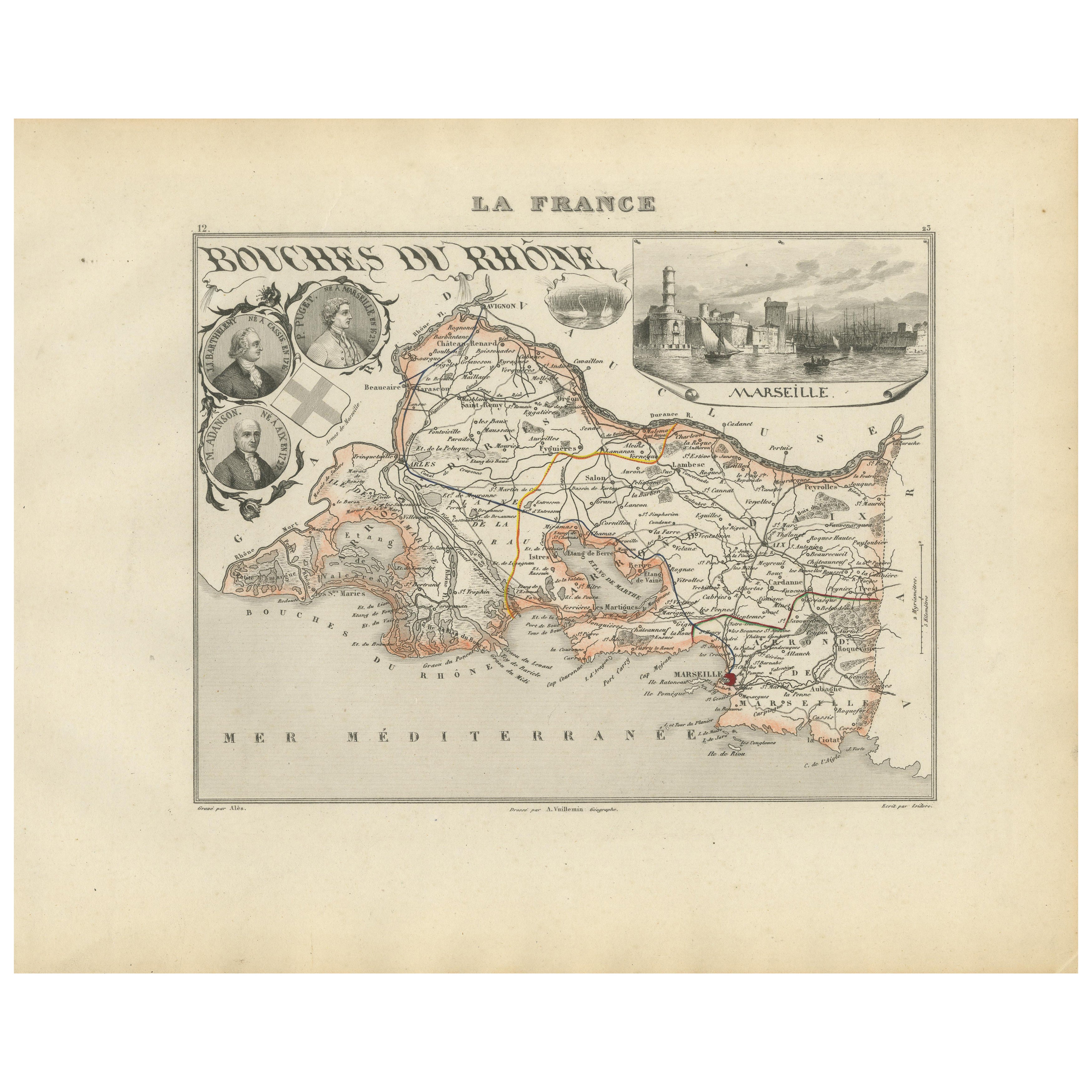
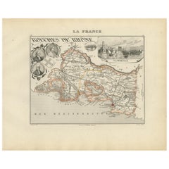
Map of Bouches-du-Rhône France with Marseille and Rhône Delta, 19th Century
Map of Bouches-du-Rhône France with Marseille and Rhône Delta, 19th Century
Description:
This finely engraved 19th-century map of the Bouches-du-Rhône department in southeastern Fra...
Categoria
Di antiquariato/d’epoca, Metà XIX secolo, Francese, Mappe
Materiali
Carta
Carta geografica antica della Francia, 1903, con inserto di Parigi e della Corsica
Titolo: Carta geografica antica della Francia, 1903, con inserto di Parigi e Corsica
Descrizione:
Questa mappa antica, intitolata "Francia", è stata incisa e pubblicata nel 1903 dal...
Categoria
Inizio XX secolo, Mappe
Materiali
Carta

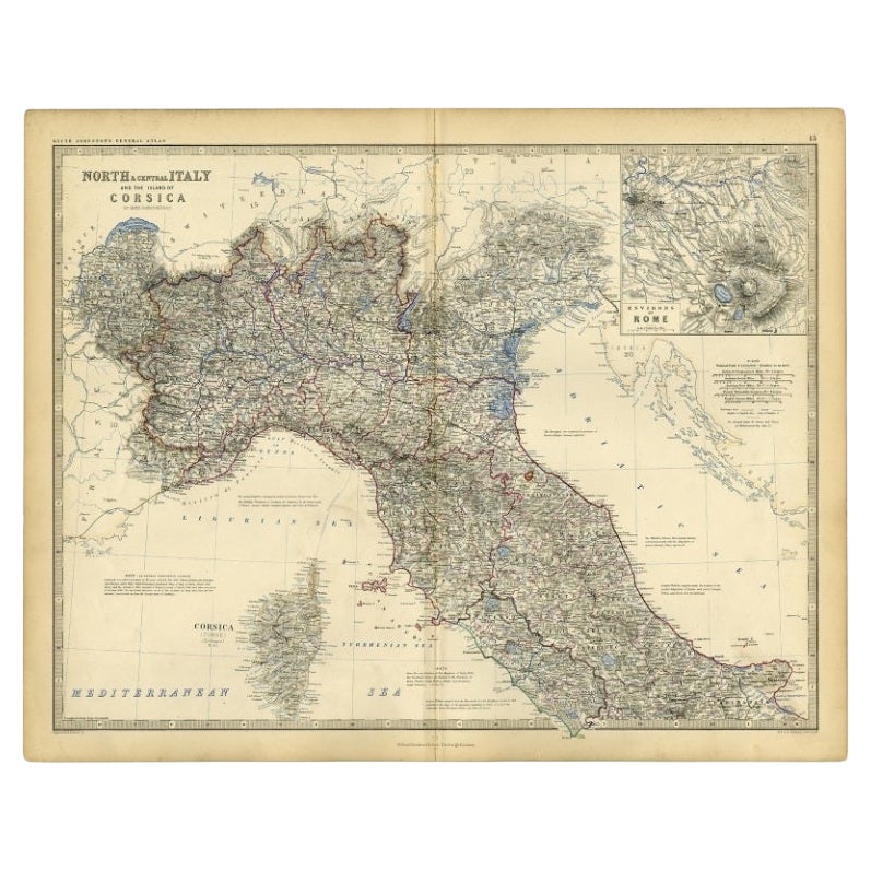
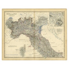
Carta geografica antica dell'Italia e della Corsica, 1860 ca.
Carta geografica antica intitolata "Italia settentrionale e centrale e l'isola di Corsica".
Carta geografica antica dell'Italia settentrionale e centrale e dell'isola di Corsica....
Categoria
Di antiquariato/d’epoca, XIX secolo, Mappe
Materiali
Carta
88 € Prezzo promozionale
20% in meno
Ti potrebbe interessare anche
Bellissima mappa a colori di Antique French del 1856 acquerellata a mano di Dept Des La Corse
Siamo lieti di offrire in vendita questa splendida mappa ad acquerello del 1856 delle Alpi austriache, intitolata Dept Des La Course, tratta dall'Atlas National Illustre y Victor Lev...
Categoria
Di antiquariato/d’epoca, Anni 1850, Francese, Primo vittoriano, Mappe
Materiali
Carta

Mappa geografica antica del Principato di Monaco
Di Bruno Santini
ST/609 - Interessante carta geografica d'epoca a colori del Principato di Monaco in lingua francese: "Carte qui contient le Principauté de Piémont, le Monferrat et la comté de Nice a...
Categoria
Di antiquariato/d’epoca, Fine XVIII secolo, Italiano, Altro, Mappe
Materiali
Carta

839 € Prezzo promozionale
20% in meno
Grande mappa originale del Sud Italia. John Dower, 1861
Grande mappa del Sud Italia
Incisione litografica di John Dower
Colore originale
Pubblicato, 1861
Non incorniciato
Buono stato
Spedizione gratuita
Categoria
Di antiquariato/d’epoca, Anni 1860, Inglese, Vittoriano, Mappe
Materiali
Carta

Mappa antica del Principato di Monaco
Di Antonio Vallardi Editore
ST/619 - "Antico Atlante Geografico d'Italia - Carta topografica dell'ex-Principato di Monaco" -
ediz Vallardi - Milano -
Un'edizione un po' speciale ---
Categoria
Di antiquariato/d’epoca, Fine XIX secolo, Italiano, Altro, Stampe
Materiali
Carta

370 € Prezzo promozionale
62% in meno
Grande mappa antica originale dell'Italia. John Dower, 1861
Ottima mappa dell'Italia
Incisione litografica di John Dower
Colore originale
Pubblicato, 1861
Non incorniciato
Buone condizioni / riparazione all'angolo in alto a destra visibi...
Categoria
Di antiquariato/d’epoca, Anni 1860, Inglese, Vittoriano, Mappe
Materiali
Carta

Italia, parte centrale e meridionale. Mappa antica Century Atlas
L'Atlante del Secolo. Italia, parte centrale e meridionale".
Mappa antica originale, 1903.
Mappe di Sicilia e Napoli.
Piega centrale come da edizione. Nome e numero della mappa sta...
Categoria
Inizio XX secolo, Vittoriano, Altre stampe
Materiali
Litografia
