Articoli simili a Map of Drôme France with Valence and Rhône Valley Wine Region, 19th Century


Vuoi altre immagini o video?
Richiedi altre immagini o video al venditore
1 di 10
Map of Drôme France with Valence and Rhône Valley Wine Region, 19th Century
140 €IVA inclusa
Informazioni sull’articolo
Map of Drôme France with Valence and Rhône Valley Wine Region, 19th Century
Description:
This beautifully engraved 19th-century map of the Drôme department in southeastern France was created by Alexandre Vuillemin and published by Migeon in Paris as part of the *Nouvel Atlas Illustré*. Combining precise geography with classical decoration, this map offers a detailed portrait of a region that bridges the Alpine foothills and the fertile Rhône Valley.
Outlined in soft hand-colored pink, the map includes towns, roads, rivers, and administrative borders. Valence, the departmental capital and a historic gateway to the south of France, is prominently placed near the top. Other notable towns such as Montélimar, Die, and Nyons are labeled with clarity, and the layout captures the topographical transition from mountainous terrain in the east to the flatter Rhône corridor in the west.
At the top right, a vignette of Valence shows the town nestled beneath the Vercors mountains. Below that is a portrait of the French dramatist Pierre-Antoine de Chamfort, who was born in Clermont-Ferrand but had associations with the intellectual life of the region. Additional engravings include a suspension bridge over the Rhône River and an image of a goat, likely referencing the local production of regional cheeses and pastoral traditions.
Drôme lies in the heart of the Côtes du Rhône wine region, particularly its southern section. The department is home to some well-regarded appellations including Crozes-Hermitage, Hermitage, and Clairette de Die. These wines—made from Syrah, Marsanne, Roussanne, and Muscat, among other grapes—are known for their rich textures, spice, and balance. In addition to viticulture, the region is also recognized for truffle production, olive oil, nougat from Montélimar, and lavender fields in the southern zones.
This antique map is a fitting tribute to Drôme’s blend of agricultural richness, cultural history, and natural beauty. It is a wonderful addition to any collection of wine-related maps, regional French art, or decorative cartography.
Condition summary:
Very good condition with slight age toning and a few minor foxing marks along the margins. The engraved lines are sharp and the original hand coloring remains vibrant.
Framing tips:
A walnut or dark oak frame will complement the regional warmth of the Drôme landscape. Use a light cream or muted lavender mat to match the coloring and draw out the engraved vignettes. UV-protective glass is recommended for preservation and clarity.
- Dimensioni:Altezza: 26,1 cm (10,28 in)Larghezza: 32,5 cm (12,8 in)Profondità: 0,2 mm (0,01 in)
- Materiali e tecniche:Carta,Inciso
- Luogo di origine:
- Periodo:
- Data di produzione:circa 1850
- Condizioni:Very good condition with slight age toning and a few minor foxing marks along the margins. The engraved lines are sharp and the original hand coloring remains vibrant.
- Località del venditore:Langweer, NL
- Numero di riferimento:Venditore: BG-13331-251stDibs: LU3054345363872
Informazioni sul venditore
5,0
Venditore riconosciuto
Questi venditori prestigiosi sono leader del settore e rappresentano il massimo in termini di qualità e design.
Venditore Platino
Venditori Premium con valutazione 4.7+ e tempi di risposta entro 24 ore
Fondazione nel 2009
Venditore 1stDibs dal 2017
2567 vendite su 1stDibs
Tempo di risposta standard: <1 ora
- SpedizioneRecupero del preventivo…Spedizione da: Langweer, Paesi Bassi
- Politica di reso
Alcune parti di questa pagina sono state tradotte automaticamente. 1stDibs non può garantire che le traduzioni siano corrette. L’inglese è la lingua predefinita del sito.
Garanzia di autenticità
Nell’improbabile caso in cui si verifichi un problema con l’autenticità di un articolo, contattaci entro un anno per ottenere un rimborso completo. DettagliGaranzia di rimborso
Se il tuo articolo non corrisponde alla descrizione, è danneggiato durante il trasporto o non arriva, contattaci entro 7 giorni per un rimborso completo. DettagliAnnullamento entro 24 ore
Hai un periodo di tolleranza di 24 ore per annullare il tuo acquisto, senza necessità di fornire spiegazioni.Venditori professionali selezionati
I nostri venditori di livello internazionale devono aderire a rigorosi standard di servizio e qualità, garantendo l’integrità delle inserzioni.Garanzia miglior prezzo
Se scopri che un venditore ha pubblicato altrove lo stesso articolo a un prezzo più basso, applicheremo lo stesso prezzo.Consegna globale affidabile
La nostra rete di vettori leader del settore offre opzioni di spedizione specializzate in tutto il mondo, inclusa la consegna personalizzata.Altro da questo venditore
Mostra tuttoMap of Allier France with Saint-Pourçain Wine Region by Vuillemin, 19th c
Map of Allier France with Saint-Pourçain Wine Region by Vuillemin, 19th c
This decorative 19th-century map of Allier, a central department of France, comes from the celebrated Nouve...
Categoria
Di antiquariato/d’epoca, Metà XIX secolo, Francese, Mappe
Materiali
Carta

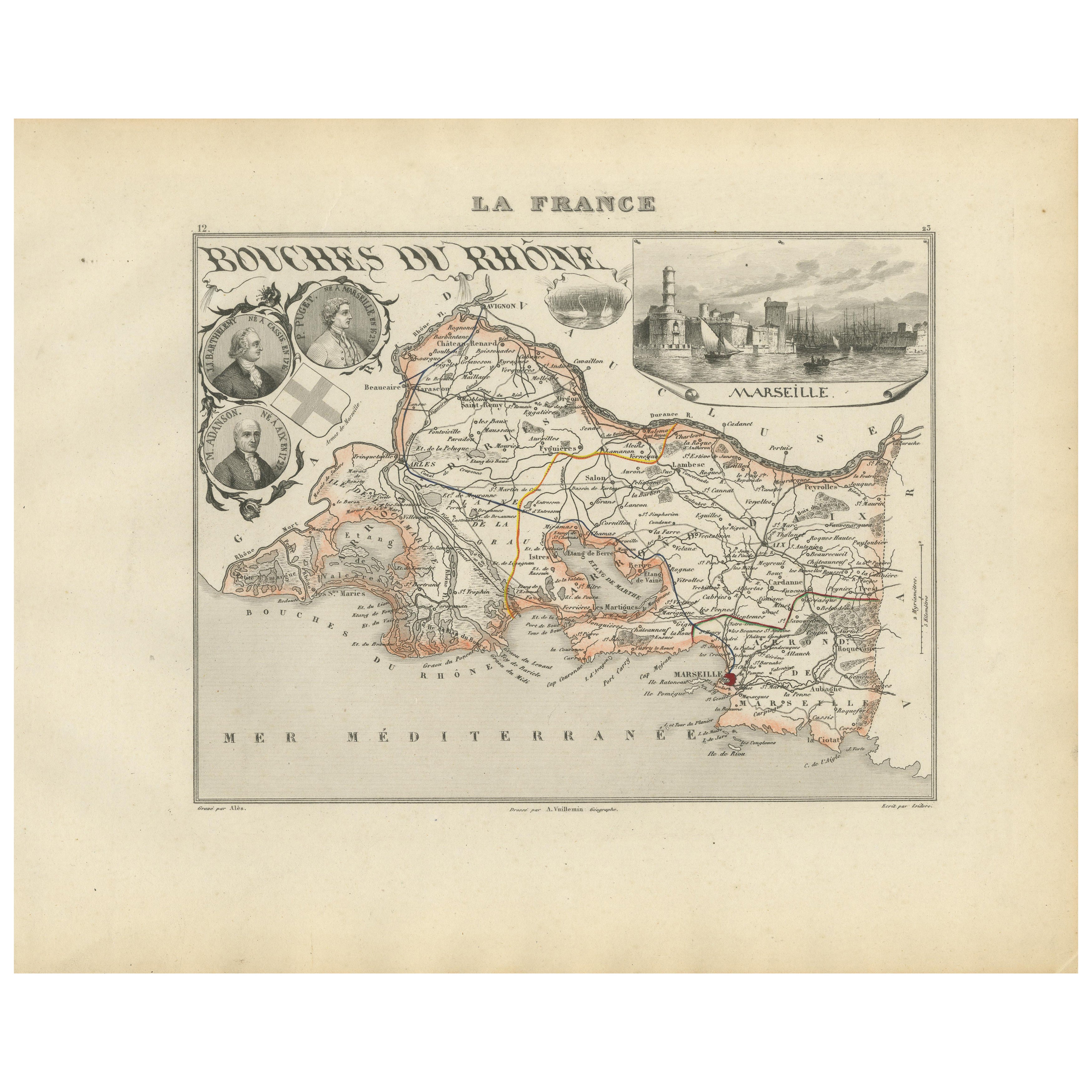
Map of Bouches-du-Rhône France with Marseille and Rhône Delta, 19th Century
Map of Bouches-du-Rhône France with Marseille and Rhône Delta, 19th Century
Description:
This finely engraved 19th-century map of the Bouches-du-Rhône department in southeastern Fra...
Categoria
Di antiquariato/d’epoca, Metà XIX secolo, Francese, Mappe
Materiali
Carta
Map of Côtes-du-Nord France with Saint-Brieuc and Brittany Coastline, c.1850
Map of Côtes-du-Nord France with Saint-Brieuc and Brittany Coastline, 19th c
Description:
This elegant 19th-century map of Côtes-du-Nord, the historic name for what is now known as ...
Categoria
Di antiquariato/d’epoca, Metà XIX secolo, Francese, Mappe
Materiali
Carta

Map of Côte-d'Or France with Dijon and Burgundy Wine Region, 19th Century
Map of Côte-d'Or France with Dijon and Burgundy Wine Region, 19th Century
Description:
This beautifully engraved 19th-century map of Côte-d'Or, located in the historic region of Bur...
Categoria
Di antiquariato/d’epoca, Metà XIX secolo, Francese, Mappe
Materiali
Carta

Map of Aisne France with Soissons and Champagne Vineyards by Vuillemin, 19th c
Map of Aisne France with Soissons and Champagne Vineyards by Vuillemin, 19th c
Description:
This richly detailed 19th-century engraved and hand-colored map of the department of Aisn...
Categoria
Di antiquariato/d’epoca, Metà XIX secolo, Francese, Mappe
Materiali
Carta

Map of Ariège France with Foix and Pyrenees Landscape by Vuillemin, 19th c
Map of Ariège France with Foix and Pyrenees Landscape by Vuillemin, 19th c
Description:
This beautifully detailed 19th-century map of the Ariège department in southwestern France wa...
Categoria
Di antiquariato/d’epoca, Metà XIX secolo, Francese, Mappe
Materiali
Carta

Ti potrebbe interessare anche
Grande mappa della Francia del XIX secolo
Grande mappa della Francia del XIX secolo.
Condizioni notevoli, con una piacevole patina di usura.
Incorniciato di recente.
Francia, circa 1874.
Categoria
Di antiquariato/d’epoca, Fine XIX secolo, Francese, Mappe
Materiali
Lino, Carta

Mappa dell'Alta Vienne - Litografia originale - XIX secolo
La Mappa dell'Alta Vienne è un'opera d'arte originale in litografia realizzata da un Incisore anonimo del XIX secolo.
Stampato nella serie di "France Pittoresque".
Intitolato "Fr...
Categoria
XIX secolo, Moderno, Stampe figurative
Materiali
Litografia

L'Isere, Francia. Mappa antica del dipartimento francese, 1856
Di Victor Levasseur
'Dept. de L'Isere', incisione in acciaio con colorazione a mano dei contorni originali, 1856, da 'Atlas National Illustre' di Levasseur.
Questa zona è nota per la produzione del Bl...
Categoria
XIX secolo, Naturalismo, Stampe (paesaggio)
Materiali
Incisione

Francia, Part One. Mappa antica Century Atlas
L'Atlante del Secolo. Francia, parte settentrionale".
Mappa antica originale, 1903.
Cartine di "Francia in Province" e "Parigi e dintorni".
Piega centrale come da edizione. Nome e ...
Categoria
Inizio XX secolo, Vittoriano, Altre stampe
Materiali
Litografia

Mappa del Rodano - Incisione originale - XIX secolo
La mappa del Rodano è un'antica incisione originale realizzata da un incisore anonimo del XIX secolo.
Stampato in serie "France Pittoresque" in alto al centro.
Lo stato di conserva...
Categoria
XIX secolo, Moderno, Stampe figurative
Materiali
Acquaforte

Aude, Francia. Mappa antica di un dipartimento francese, 1856
Di Victor Levasseur
'Dept. de L' Aude', incisione in acciaio con colorazione a mano dei contorni originali, 1856, da 'Atlas National Illustre' di Levasseur.
Questa zona della Francia è famosa per l'am...
Categoria
XIX secolo, Naturalismo, Stampe (paesaggio)
Materiali
Incisione
