Articoli simili a Map of Finistère France with Brest, Quimper and Brittany Coastline, 19th Century


Vuoi altre immagini o video?
Richiedi altre immagini o video al venditore
1 di 10
Map of Finistère France with Brest, Quimper and Brittany Coastline, 19th Century
140 €IVA inclusa
Informazioni sull’articolo
Map of Finistère France with Brest, Quimper and Brittany Coastline, 19th Century
Description:
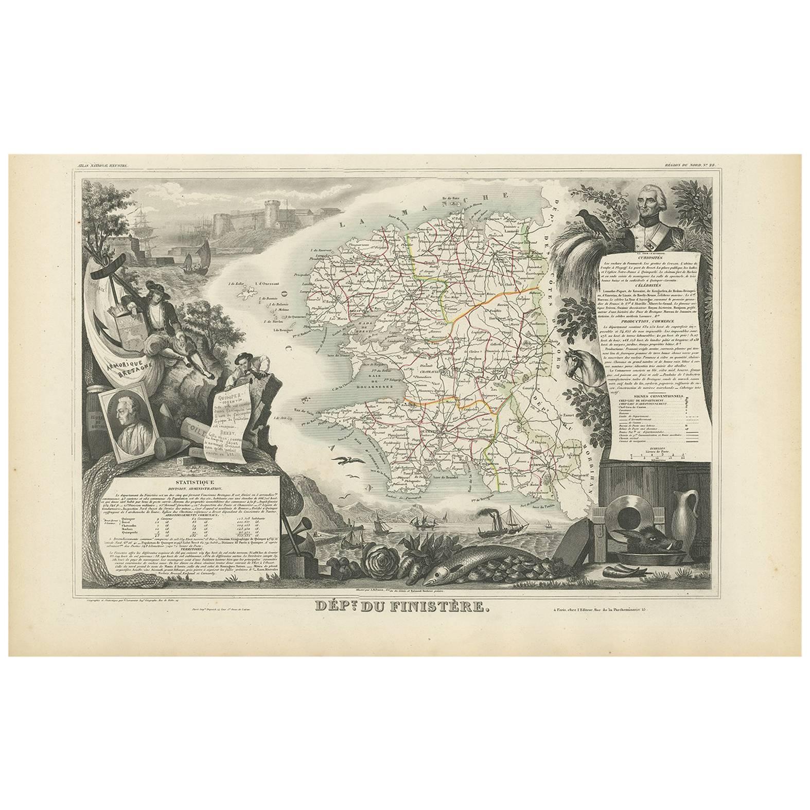
This richly engraved 19th-century map of Finistère, the westernmost department of mainland France, was drawn by Alexandre Vuillemin and published by Migeon in Paris for the *Nouvel Atlas Illustré*. The map offers a finely detailed view of this culturally distinct and geographically dramatic region, renowned for its rugged coastline, maritime heritage, and Celtic traditions.
Finistère, meaning "end of the land" in Latin, is presented here with its departmental boundaries hand-colored in soft pink. The map clearly delineates towns, roads, rivers, and coastal features, including the Crozon Peninsula and islands such as Ouessant and Sein. Quimper, the prefecture, and Brest, a strategic naval base, are prominently marked along with other key towns like Morlaix, Douarnenez, and Concarneau.
In the lower left corner is an engraved vignette of the harbor at Quimper, depicting a sailing vessel, waterfront buildings, and a view of the Gothic cathedral. On the right stands a full-length statue of a revolutionary figure, General Hoche, who led troops in Brittany during the counter-revolutionary uprisings. The top left features the coat of arms of Finistère, bearing a ship and marine imagery appropriate to this seafaring region.
Finistère forms part of Brittany (Bretagne), a region steeped in Celtic culture, Breton language, and maritime history. While not a major wine-producing area, the department is famous for its cider, seafood (especially oysters and scallops), buckwheat galettes, and dairy products. Its coastal geography and strong winds have made it a critical location for lighthouses, fishing ports, and naval defenses for centuries.
This antique map is both decorative and historically informative, ideal for collectors interested in Brittany, French maritime history, or regional ethnography. It reflects the cultural independence and dramatic geography of France’s far western frontier.
Condition summary:
Very good condition with minor age toning and light foxing near the edges. Engraved lines are crisp and the original hand coloring remains clean and consistent.
Framing tips:
A rustic oak or driftwood frame complements the coastal and Breton character of the map. A cream or light gray mat enhances the engraving and soft pink tones. UV-protective glass is recommended for preservation and clarity.
- Dimensioni:Altezza: 32,5 cm (12,8 in)Larghezza: 26,1 cm (10,28 in)Profondità: 0,2 mm (0,01 in)
- Materiali e tecniche:Carta,Inciso
- Luogo di origine:
- Periodo:
- Data di produzione:circa 1850
- Condizioni:Very good condition with minor age toning and light foxing near the edges. Engraved lines are crisp and the original hand coloring remains clean and consistent.
- Località del venditore:Langweer, NL
- Numero di riferimento:Venditore: BG-13331-281stDibs: LU3054345363902
Informazioni sul venditore
5,0
Venditore riconosciuto
Questi venditori prestigiosi sono leader del settore e rappresentano il massimo in termini di qualità e design.
Venditore Platino
Venditori Premium con valutazione 4.7+ e tempi di risposta entro 24 ore
Fondazione nel 2009
Venditore 1stDibs dal 2017
2534 vendite su 1stDibs
Tempo di risposta standard: <1 ora
- SpedizioneRecupero del preventivo…Spedizione da: Langweer, Paesi Bassi
- Politica di reso
Alcune parti di questa pagina sono state tradotte automaticamente. 1stDibs non può garantire che le traduzioni siano corrette. L’inglese è la lingua predefinita del sito.
Garanzia di autenticità
Nell’improbabile caso in cui si verifichi un problema con l’autenticità di un articolo, contattaci entro un anno per ottenere un rimborso completo. DettagliGaranzia di rimborso
Se il tuo articolo non corrisponde alla descrizione, è danneggiato durante il trasporto o non arriva, contattaci entro 7 giorni per un rimborso completo. DettagliAnnullamento entro 24 ore
Hai un periodo di tolleranza di 24 ore per annullare il tuo acquisto, senza necessità di fornire spiegazioni.Venditori professionali selezionati
I nostri venditori di livello internazionale devono aderire a rigorosi standard di servizio e qualità, garantendo l’integrità delle inserzioni.Garanzia miglior prezzo
Se scopri che un venditore ha pubblicato altrove lo stesso articolo a un prezzo più basso, applicheremo lo stesso prezzo.Consegna globale affidabile
La nostra rete di vettori leader del settore offre opzioni di spedizione specializzate in tutto il mondo, inclusa la consegna personalizzata.Altro da questo venditore
Mostra tuttoMap of Côtes-du-Nord France with Saint-Brieuc and Brittany Coastline, c.1850
Map of Côtes-du-Nord France with Saint-Brieuc and Brittany Coastline, 19th c
Description:
This elegant 19th-century map of Côtes-du-Nord, the historic name for what is now known as ...
Categoria
Di antiquariato/d’epoca, Metà XIX secolo, Francese, Mappe
Materiali
Carta

Carta geografica antica del Finistère "Francia" di V. Levasseur, 1854
Di Victor Levasseur
Carta geografica antica intitolata "Dépt. du Finistère". Mappa del dipartimento francese del Finistère, Bretagna, Francia. Questa zona della Francia è nota per la produzione di sidro...
Categoria
Di antiquariato/d’epoca, Metà XIX secolo, Mappe
Materiali
Carta
144 € Prezzo promozionale
20% in meno
Map of Allier France with Saint-Pourçain Wine Region by Vuillemin, 19th c
Map of Allier France with Saint-Pourçain Wine Region by Vuillemin, 19th c
This decorative 19th-century map of Allier, a central department of France, comes from the celebrated Nouve...
Categoria
Di antiquariato/d’epoca, Metà XIX secolo, Francese, Mappe
Materiali
Carta

Mappa colorata a mano della Francia nord-occidentale - dalla Bretagna alla Loira, 1858
Carta geografica antica della Francia nordoccidentale - Incisione di Stülpnagel, Justus Perthes 1858
Mappa della Francia nordoccidentale della metà del XIX secolo, incredibilmente d...
Categoria
Di antiquariato/d’epoca, Metà XIX secolo, Tedesco, Mappe
Materiali
Carta
Map of Aisne France with Soissons and Champagne Vineyards by Vuillemin, 19th c
Map of Aisne France with Soissons and Champagne Vineyards by Vuillemin, 19th c
Description:
This richly detailed 19th-century engraved and hand-colored map of the department of Aisn...
Categoria
Di antiquariato/d’epoca, Metà XIX secolo, Francese, Mappe
Materiali
Carta

Map of Gard France with Pont du Gard and Wine Regions by Vuillemin, 19th c
Title: Map of Gard France with Pont du Gard and Wine Regions by Vuillemin, 19th c
Description:
This finely engraved 19th-century map of the department of Gard in southern France was...
Categoria
Di antiquariato/d’epoca, Metà XIX secolo, Francese, Mappe
Materiali
Carta

Ti potrebbe interessare anche
Grande mappa della Francia del XIX secolo
Grande mappa della Francia del XIX secolo.
Condizioni notevoli, con una piacevole patina di usura.
Incorniciato di recente.
Francia, circa 1874.
Categoria
Di antiquariato/d’epoca, Fine XIX secolo, Francese, Mappe
Materiali
Lino, Carta

Mappa della Francia - Acquaforte - 1820
La mappa della Francia è un'acquaforte originale realizzata da un artista sconosciuto del XIX secolo nel 1820.
Ottimo stato su due fogli di carta bianca uniti al centro.
La mappa è...
Categoria
Anni 1820, Moderno, Stampe figurative
Materiali
Acquaforte

Francia, Part One. Mappa antica Century Atlas
L'Atlante del Secolo. Francia, parte settentrionale".
Mappa antica originale, 1903.
Cartine di "Francia in Province" e "Parigi e dintorni".
Piega centrale come da edizione. Nome e ...
Categoria
Inizio XX secolo, Vittoriano, Altre stampe
Materiali
Litografia

Indre e Loira, Francia. Mappa antica di un dipartimento francese, 1856
Di Victor Levasseur
'Dept. d'Indre et Loire', incisione in acciaio con colorazione a mano dei contorni originali, 1856, da 'Atlas National Illustre' di Levasseur.
Questa zona è nota per la produzione ...
Categoria
XIX secolo, Naturalismo, Stampe (paesaggio)
Materiali
Incisione

La Gironda, Francia. Mappa antica di un dipartimento francese, 1856
Di Victor Levasseur
La Gironda", incisione in acciaio con colorazione a mano dei contorni originali, 1856, da "Atlas National Illustre" di Levasseur.
Questo dipartimento costiero è la sede della regio...
Categoria
XIX secolo, Naturalismo, Stampe (paesaggio)
Materiali
Incisione

Mappa della Vandea - Acquaforte - XIX secolo
La Mappa della Vandea è un'incisione realizzata da un incisore anonimo del XIX secolo.
Stampato in serie "France Pittoresque" in alto al centro.
Lo stato di conservazione dell'oper...
Categoria
XIX secolo, Moderno, Stampe figurative
Materiali
Acquaforte
