Articoli simili a Animal Distribution Map by A.K. Johnston – Fauna by Climate Zones 1852


Vuoi altre immagini o video?
Richiedi altre immagini o video al venditore
1 di 11
Animal Distribution Map by A.K. Johnston – Fauna by Climate Zones 1852
260 €per articolo|IVA inclusa
Quantità
Informazioni sull’articolo
Animal Distribution Map by A.K. Johnston – Fauna by Climate Zones 1852
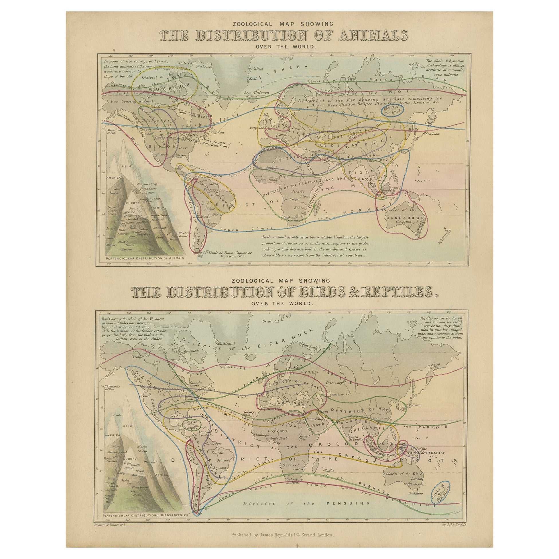
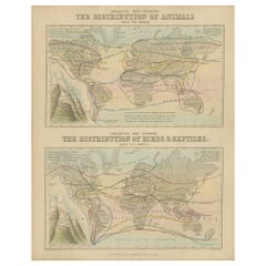
This beautifully engraved chart titled "The Distribution of Animals Including the Mammalia, Birds, Reptiles & Fishes; According to Zones of Climate" was created by Alexander Keith Johnston and published in 1852 by William Blackwood & Sons, Edinburgh and London. It appears as Plate 16 in Johnston’s influential *Physical Atlas of Natural Phenomena*, one of the most important thematic atlases of the 19th century.
This map presents a global view of the natural distribution of animals based on climatic zones, highlighting how temperature, geography, and elevation influence animal habitats. The world is divided into major climate zones such as the "Temperate Fauna," "Tropical Fauna," and "Zones of Perpetual Ice and Snow," with red typography identifying characteristic species of mammals, birds, reptiles, and marine life in each region.
Notable animal groups are labeled in situ, such as the polar bear, right whale, llama, lion, elephant, condor, kangaroo, and reindeer. Faunal regions across Asia, Africa, the Americas, Australia, and the Arctic are described in broad zoological terms. The map distinguishes between terrestrial and marine fauna, with references to oceanic zones for species like whales and seals, while also noting elevation-related changes in animal life.
Beneath the main map is a detailed comparative diagram titled "Distribution of Animals in a Vertical Direction," showing how animal species vary with altitude across major mountain systems in the Western and Eastern Hemispheres. Mountains like the Andes, Alps, Himalayas, and the Rocky Mountains are illustrated with fauna labeled at different heights—from mountain goats and condors to tigers and leopards—illustrating the vertical stratification of animal habitats.
Alexander Keith Johnston (1804–1871) was a pioneer in thematic cartography and served as Geographer in Ordinary to Queen Victoria. His *Physical Atlas* combined scientific rigor with visual clarity and artistic precision, making complex environmental and biological data both accessible and visually compelling.
This plate is ideal for collectors of natural history, early zoological science, or antique educational prints. It also serves as an elegant decorative piece for libraries, studies, or offices with a scientific or historical theme.
Condition and framing tips:
Very good condition with mild age toning and a clean image area. Original centerfold present. Frame in dark wood or black with a neutral or ivory mat to enhance the subtle red and green tones and the delicate engravings. A fine piece for natural history enthusiasts and vintage map collectors alike.
- Dimensioni:Altezza: 27,4 cm (10,79 in)Larghezza: 34,5 cm (13,59 in)Profondità: 0,2 mm (0,01 in)
- Materiali e tecniche:
- Luogo di origine:
- Periodo:
- Data di produzione:1852
- Condizioni:Very good condition. Light overall toning near the margins and some offset over Europe. The paper remains strong and well-preserved. Folding line as issued.
- Località del venditore:Langweer, NL
- Numero di riferimento:Venditore: BG-13207-161stDibs: LU3054345393532
Informazioni sul venditore
5,0
Venditore riconosciuto
Questi venditori prestigiosi sono leader del settore e rappresentano il massimo in termini di qualità e design.
Venditore Platino
Venditori Premium con valutazione 4.7+ e tempi di risposta entro 24 ore
Fondazione nel 2009
Venditore 1stDibs dal 2017
2565 vendite su 1stDibs
Tempo di risposta standard: <1 ora
- SpedizioneRecupero del preventivo…Spedizione da: Langweer, Paesi Bassi
- Politica di reso
Alcune parti di questa pagina sono state tradotte automaticamente. 1stDibs non può garantire che le traduzioni siano corrette. L’inglese è la lingua predefinita del sito.
Garanzia di autenticità
Nell’improbabile caso in cui si verifichi un problema con l’autenticità di un articolo, contattaci entro un anno per ottenere un rimborso completo. DettagliGaranzia di rimborso
Se il tuo articolo non corrisponde alla descrizione, è danneggiato durante il trasporto o non arriva, contattaci entro 7 giorni per un rimborso completo. DettagliAnnullamento entro 24 ore
Hai un periodo di tolleranza di 24 ore per annullare il tuo acquisto, senza necessità di fornire spiegazioni.Venditori professionali selezionati
I nostri venditori di livello internazionale devono aderire a rigorosi standard di servizio e qualità, garantendo l’integrità delle inserzioni.Garanzia miglior prezzo
Se scopri che un venditore ha pubblicato altrove lo stesso articolo a un prezzo più basso, applicheremo lo stesso prezzo.Consegna globale affidabile
La nostra rete di vettori leader del settore offre opzioni di spedizione specializzate in tutto il mondo, inclusa la consegna personalizzata.Altro da questo venditore
Mostra tuttoMappa antica che mostra la divisione e la distribuzione dei mammiferi di Johnston del 1850
Carta geografica antica intitolata "Divisione geografica e distribuzione dei mammiferi degli ordini rodentia e ruminantia nel mondo". Mappa antica originale che mostra la divisione g...
Categoria
Di antiquariato/d’epoca, Metà XIX secolo, Mappe
Materiali
Carta

160 € Prezzo promozionale
20% in meno
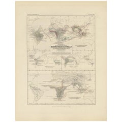
Carta zoologica antica, 1843
Due antiche mappe del mondo su un unico foglio. La mappa superiore mostra la distribuzione degli animali nel mondo. La mappa inferiore mostra la distribuzione di uccelli e rettili ne...
Categoria
Di antiquariato/d’epoca, XIX secolo, Mappe
Materiali
Carta
176 € Prezzo promozionale
20% in meno
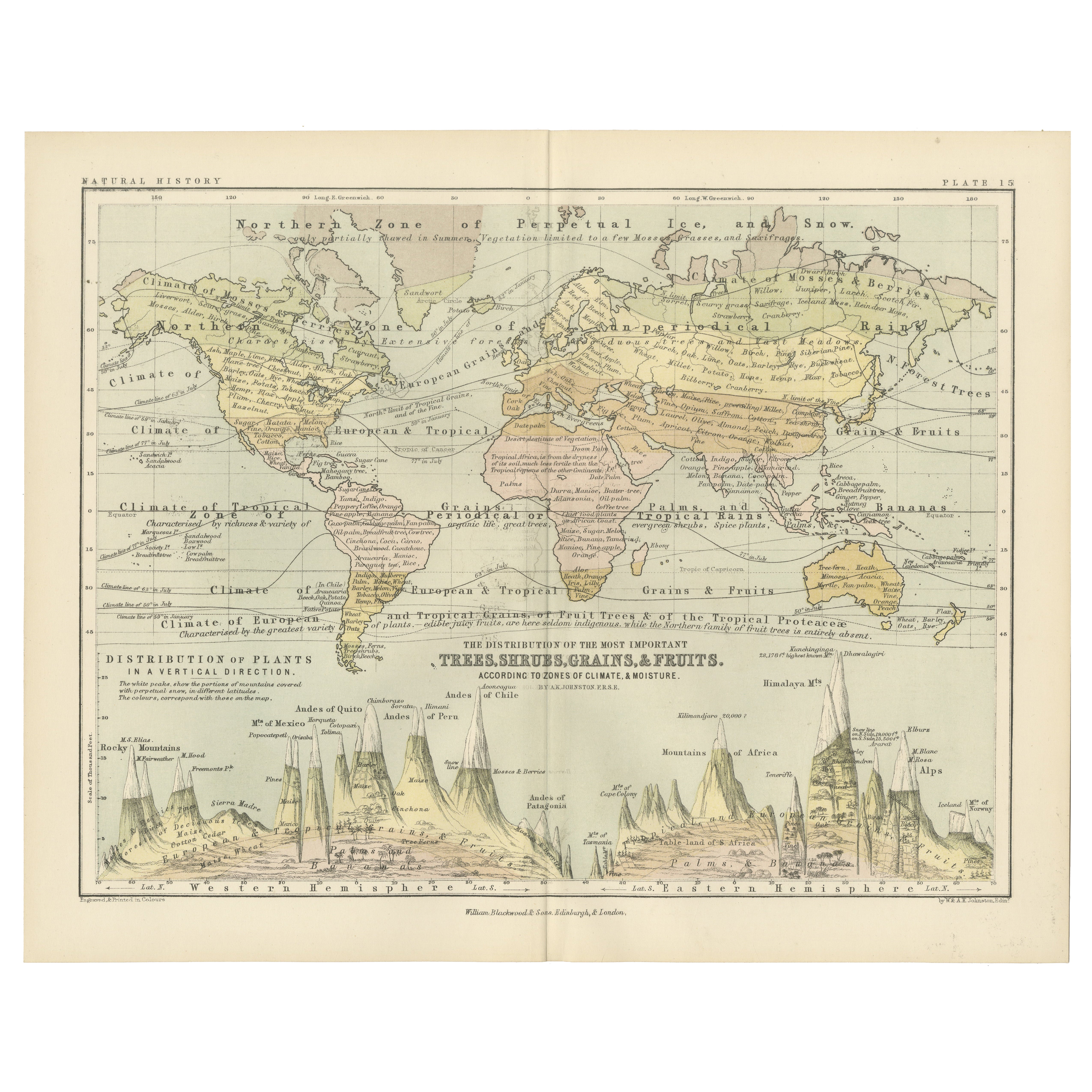
Botanical Map by A.K. Johnston – Global Plant Distribution Chart 1852
Botanical Map by A.K. Johnston – Global Plant Distribution Chart 1852
This remarkable antique chart titled "The Distribution of the Most Important Trees, Shrubs, Grains, & Fruits Ac...
Categoria
Di antiquariato/d’epoca, Metà XIX secolo, Scozzese, Stampe
Materiali
Carta
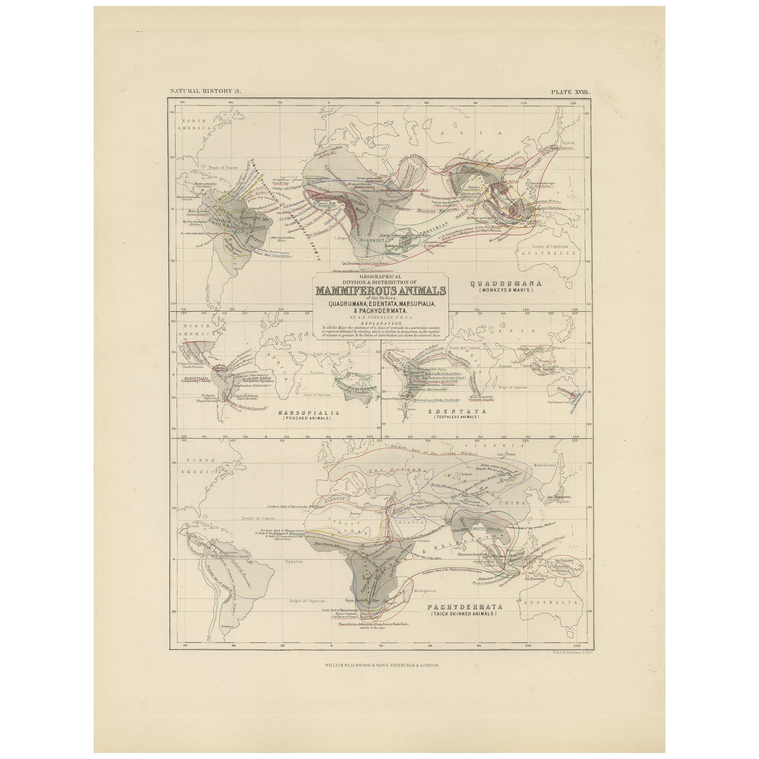
Mappa antica che mostra la divisione e la distribuzione dei mammiferi di Johnston del 1850
Carta geografica antica intitolata "Divisione geografica e distribuzione dei mammiferi degli ordini quadrumana, edentata, marsupialia e pachidermata". Mappa antica originale che most...
Categoria
Di antiquariato/d’epoca, Metà XIX secolo, Mappe
Materiali
Carta
130 € Prezzo promozionale
35% in meno
Ethnographic Map of the World by A.K. Johnston – Races of Man Chart 1852
Ethnographic Map of the World by A.K. Johnston – Races of Man Chart 1852
This antique map titled "Ethnographic Map of the World Showing the Present Distribution of the Leading Races...
Categoria
Di antiquariato/d’epoca, Metà XIX secolo, Scozzese, Stampe
Materiali
Carta
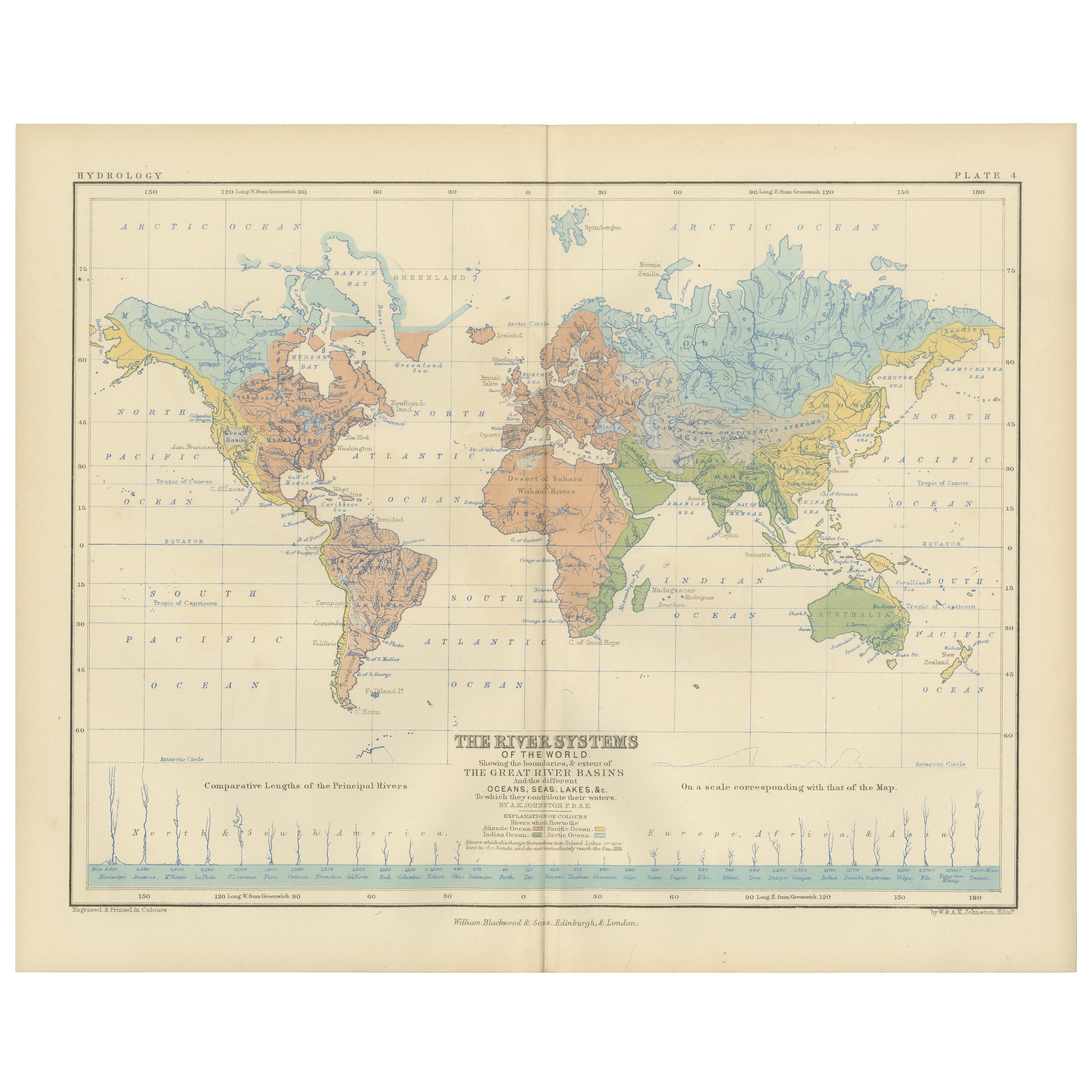
River Systems Map of the World by A.K. Johnston – Educational Print 1852
River Systems Map of the World by A.K. Johnston – Educational Print 1852
This striking 1852 map titled "The River Systems of the World" was created by the noted Scottish geographer ...
Categoria
Di antiquariato/d’epoca, Metà XIX secolo, Scozzese, Stampe
Materiali
Carta

Ti potrebbe interessare anche
Mappa antica originale del mondo di Dower, 1835 circa
Bella mappa del mondo
Disegnato e inciso da J.Dower
Pubblicato da Orr & Smith. C.1835
Senza cornice.
Spedizione gratuita
Categoria
Di antiquariato/d’epoca, Anni 1830, Inglese, Mappe
Materiali
Carta

1864 Planisfero originale illustrato - Mappa del mondo - Geografia
Immergiti nell'epico viaggio del passato con il Planisfero Storico Illustrato del 1864 di Charpentier! 🗺️ Questo tesoro cartografico ti trasporta attraverso le complessità della sto...
Categoria
Anni 1860, Stampe e riproduzioni
Materiali
Lino, Litografia, Carta

Mappa antica originale del mondo di Thomas Clerk, 1817
Grande mappa dell'emisfero orientale e occidentale
Su 2 fogli
Incisione su rame
Disegnato e inciso da Thomas Clerk, Edimburgo.
Pubblicato da Mackenzie And Dent, 1817
N...
Categoria
Di antiquariato/d’epoca, Anni 1810, Inglese, Mappe
Materiali
Carta

Mappa dell'Impero Britannico - Mappa antica di Karl Spruner - 1760 ca.
Di Karl Spruner von Merz
La Mappa dell'Impero Britannico è un'opera d'arte realizzata intorno al 1760 da Karl Spruner.
Stampa originale colorata a mano.
Buone condizioni, a parte l'ingiallimento della cart...
Categoria
Anni 1760, Moderno, Stampe figurative
Materiali
Acquaforte

Grande mappa antica originale del mondo, Fullarton, 1870 ca.
Grande mappa del mondo. Mostra entrambi gli emisferi
Dal celebre Atlante Reale Illustrato
Litografia. Colore originale.
Pubblicato da Fullarton, Edimburgo, 1870 ca.
Senza cornic...
Categoria
Di antiquariato/d’epoca, Anni 1870, Scozzese, Mappe
Materiali
Carta

Mappa antica originale dell'emisfero orientale di Dower, 1835 circa
Bella mappa dell'emisfero orientale
Disegnato e inciso da J.Dower
Pubblicato da Orr & Smith. C.1835
Senza cornice.
Spedizione gratuita
Categoria
Di antiquariato/d’epoca, Anni 1830, Inglese, Mappe
Materiali
Carta
