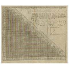
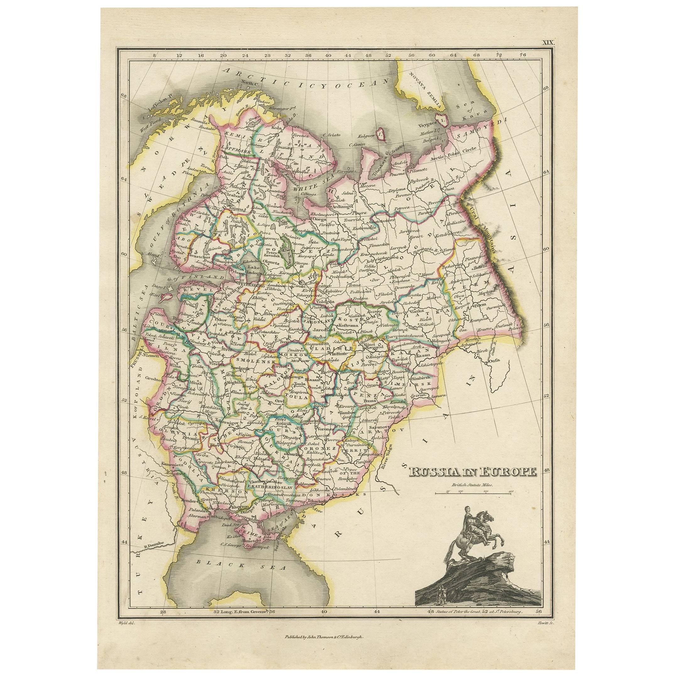
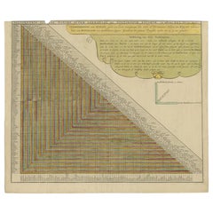
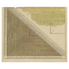
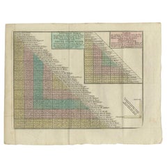
Antique Chart of Travelling Distances between European Cities, Ca.1792
View Similar Items


Want more images or videos?
Request additional images or videos from the seller
1 of 5
Auction endedBrowse Current Auctions
Antique Chart of Travelling Distances between European Cities, Ca.1792
About the Item
- Dimensions:Height: 21.07 in (53.5 cm)Width: 24.41 in (62 cm)Depth: 0 in (0.01 mm)
- Materials and Techniques:
- Period:
- Date of Manufacture:circa 1792
- Condition:
- Seller Location:Langweer, NL
- Reference Number:Seller: BG-11670-71stDibs: LU3054326401862
About the Seller
5.0
Platinum Seller
These expertly vetted sellers are 1stDibs' most experienced sellers and are rated highest by our customers.
Established in 2009
1stDibs seller since 2017
1,965 sales on 1stDibs
More From This SellerView All
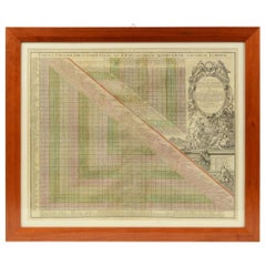
- Antique Chart of Travelling Distances Between European Cities, ca. 1726Located in Langweer, NLAntique print Europe titled 'Poliometria Europae Maxime Autem Germaniae ac Finitimorum Locorum'. This unusual chart depicts the traveling distances between various European cities. ...Category
Antique 18th Century Prints
MaterialsPaper
- Unusual Chart Showing Traveling Distances Between European Cities, C.1726Located in Langweer, NLAntique print Europe titled 'Poliometria Europae Maxime Autem Germaniae ac Finitimorum Locorum'. This unusual chart depicts the traveling distances between various European citie...Category
Antique 1720s Prints
MaterialsPaper
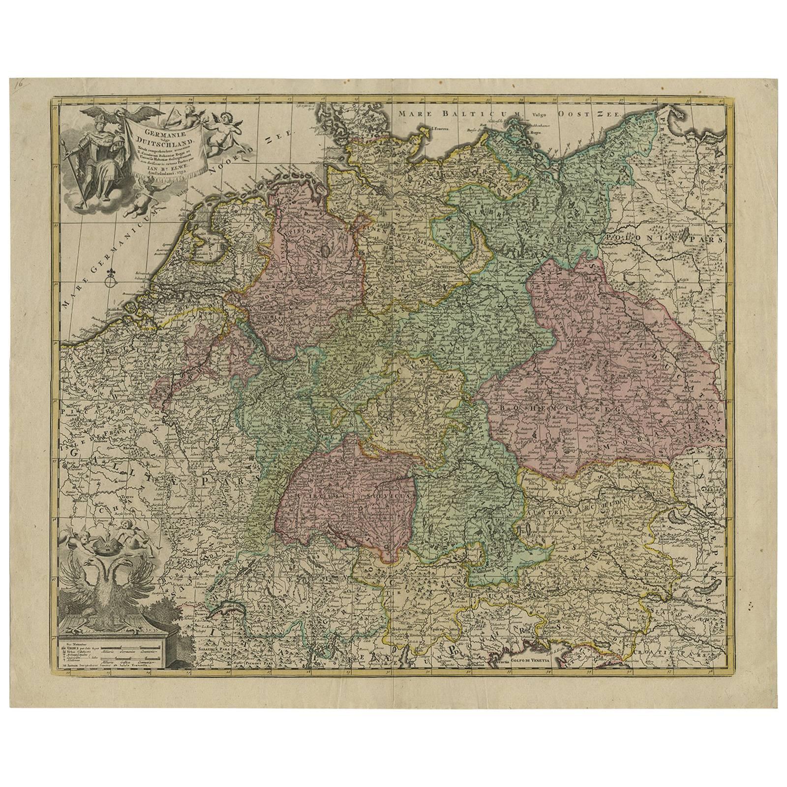
- Antique Sea Chart of the Shetland Islands, Scotland, ca.1745Located in Langweer, NLAntique map of Scotland titled 'Nieuwe Paskaard van Hitland met de daar omleggende eylanden na de nieuwe aftekening gemaakt by den Lofwaarden en onvermoeyden Hit en Zeeman Ian Bruyst...Category
Antique 1740s Maps
MaterialsPaper
 $1,107 Sale Price20% Off
 - Antique Map of Northern Europe and European Russia, ca.1780Located in Langweer, NLAntique map titled 'Le Nord de L'Europe, Contenant Le Danemark, La Norwege; La Suede et La Laponie avec la Majeure Partie de al Russie Europeenne.' Map of Northern Europe and Eur...Category
Antique 1780s Maps
MaterialsPaper
- Antique Genealogy Chart of the Leaders of Europe by Chatelain, 1732Located in Langweer, NLAntique print titled 'Carte Genealogique des Souverains de l'Europe (..)'. Chart of the royal line of the great Frankish major, Aega. As early as the 14th century the Hapsburgs attem...Category
Antique 18th Century Prints
MaterialsPaper
- Antique Distance Table Between the Main Cities of Europe by Keizer & De Lat 1788Located in Langweer, NLAntique print titled 'Nieuwe Steede-Wyser (..)'. Original antique distance table between the main cities of Europe. This print originates from 'Nieuwe Natuur- Geschied- en Handelkund...Category
Antique 18th Century Prints
MaterialsPaper

You May Also LikeView All
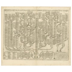
- 1731 Original German Engraving Print Chart of European Distances by T. MayerLocated in Milan, ITTabula Poliometrica Germaniae ac Praecipuorum quorundam locorum Europae Nuremberg, 1731. Author: T. Mayer; publisher: Homman. Chart printed by engraving on copper plate, coeval color...Category
Antique 1730s German Scientific Instruments
MaterialsGlass, Wood, Paper
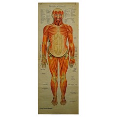
- Antique Foldable Anatomical Wall Chart Depicting Human MusculatureLocated in Berghuelen, DEAntique Foldable Anatomical Wall Chart Depicting Human Musculature The rare 19th century anatomical wall chart depicts the human musculature and inter...Category
Early 20th Century German Victorian Prints
MaterialsWood, Paper
- Antique Anatomical Wall Chart Depicting the Human SkeletonLocated in Berghuelen, DEA rare 19th century anatomical wall chart depicting the human skeleton. On the sides On the sides are detailed description in German language. The wall...Category
Early 20th Century German Victorian Prints
MaterialsPaper
- Genito-Urinary Anatomical Chart Fritz FrohseBy Nystrom / Frohse Art, Fritz FrohseLocated in Philadelphia, PAGenito-Urinary Anatomical Chart by Fritz Frohse. Dated 1922. Paper mounted on canvas. Shows wear but still presents very well!Category
Vintage 1920s German American Classical Prints
MaterialsCanvas, Paper
- Foldable Anatomical Wall Chart Depicting Human MusculatureLocated in Berghuelen, DEA rare 19th century anatomical wall chart depicting human musculature and internal organs. With removable multicolored human organs like lung, heart, l...Category
Early 20th Century German Victorian Prints
MaterialsPaper
- 1918 American Frohse Anatomical Chart, A. J. Nystrom, Max Brodel IllustratorBy Max Brödel, A.J. Nystrom & CoLocated in Buffalo, NYAntique American Frohse Anatomical pull down chart, by A. J. Nystrom, ,revised and augmented by Max Brodel illustrator... Amazing color, patina, age appropriate wear. dated 1918.. Max (Paul Heinrich) Brödel 1870-1941 Brödel, an illustrator and the first director of the Art as Applied to Medicine program at Johns Hopkins...Category
Vintage 1910s American Steampunk Prints
MaterialsWood, Paper


Recently Viewed
View AllMore Ways To Browse
City Used Office Furniture
Antique European Plates
Antique Charts
Old Maps Of Europe
City Map Lithograph
Metal Plate Engraved B
Old Maxime
Antique Ac
World Map Globe
Antique Furniture Rollers
Swiss Antiques And Collectables
Antique Roman Map
Antique School Map
Antique School Maps
East India Map
Map Hondius
Antique Maps South America
Ireland Antiques