Items Similar to 1907 Map of Colorado, Antique Topographical Map, by Louis Nell


Video Loading
Want more images or videos?
Request additional images or videos from the seller
1 of 6
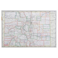
1907 Map of Colorado, Antique Topographical Map, by Louis Nell
About the Item
This highly detailed pocket map is a topographical map of the state of Colorado by Louis Nell from 1907. The map "has been complied from all available surveys in existence... [I]t is consequently the most complete and accurate one ever published, and shows all the information useful to settlers, miners and travelers."
The map is fully engraved with virtually no area left untouched by the engraver. The map is colored to indicate Forest Reserves, agricultural lands, timber reserves, watersheds, and creeks. Towns, villages, settlements, mining areas, railroads and townships are also highlighted. The map is drawn on a scale of 10 miles to every 1 inch.
Louis Nell traveled to Colorado in the mid-1870s as a topographical assistant to leading cartographer George Wheeler. Nell enjoyed the area so much that he settled there and published a series of maps of the state between the years 1880 and 1907. He formed one of the most continuous cartographic records available for the period immediately following Colorado statehood. His intensely detailed maps captured the rapid development of the state, including the great Silver Boom during the late 19th century. This is the final edition, sold by the Kendrick Book & Stationery Company, and is a very scarce issue.
Condition:
Overall very good condition. Some visible wear along fold lines. Printed color is bold. Paper is healthy, with no tears.
The map has been framed according to the highest conservation standards. The framed dimensions: 45 1/2" H x 55 1/2" W x 3" D.
- Dimensions:Height: 45.5 in (115.57 cm)Width: 55.5 in (140.97 cm)Depth: 3 in (7.62 cm)
- Materials and Techniques:
- Place of Origin:
- Period:1900-1909
- Date of Manufacture:1907
- Condition:Wear consistent with age and use. Overall very good condition. Some visible wear along fold lines. Printed color is bold. Paper is healthy, with no tears.
- Seller Location:Colorado Springs, CO
- Reference Number:
About the Seller
4.9
Platinum Seller
These expertly vetted sellers are 1stDibs' most experienced sellers and are rated highest by our customers.
Established in 2010
1stDibs seller since 2011
404 sales on 1stDibs
Typical response time: <1 hour
- ShippingRetrieving quote...Ships From: Colorado Springs, CO
- Return PolicyA return for this item may be initiated within 10 days of delivery.
More From This SellerView All
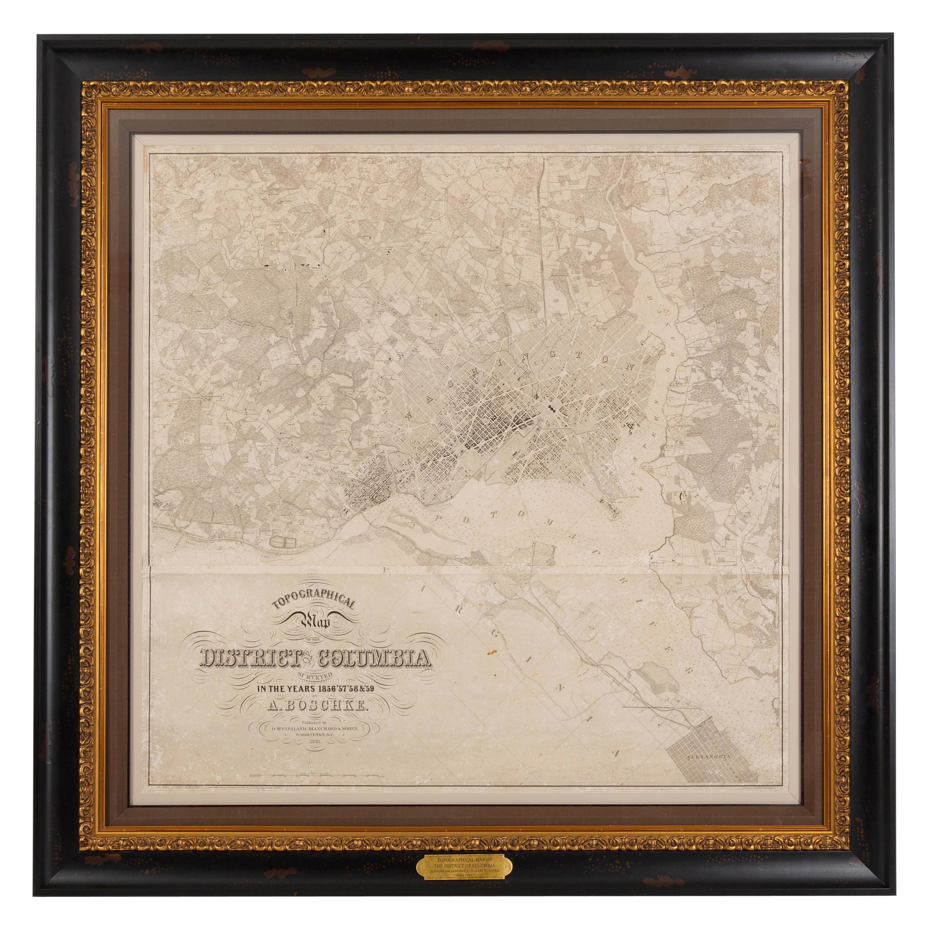
- 1861 Topographical Map of the District of Columbia, by Boschke, Antique MapLocated in Colorado Springs, COPresented is an original map of Albert Boschke's extremely sought-after "Topographical Map of the District of Columbia Surveyed in the Years 1856 ...Category
Antique 1860s American Historical Memorabilia
MaterialsPaper
- 1865 "Johnson's Nebraska, Dakota, Colorado, Idaho & Kansas" Map, Johnson & WardLocated in Colorado Springs, COPresented is an original 1865 "Johnson's Nebraska, Dakota, Colorado, Idaho & Kansas” map. This map was issued as page 63 in the 1865 edition of “Johnson's N...Category
Antique Mid-19th Century Maps
MaterialsPaper
- 1865 "Johnson's California, Utah, Nevada, Colorado, New Mexico, Arizona" MapLocated in Colorado Springs, COPresented is an original 1865 "Johnson's California, with Territories of Utah, Nevada, Colorado, New Mexico, and Arizona” map. First published in 1864, thi...Category
Antique Mid-19th Century Maps
MaterialsPaper
- 1864 Map of North America, Antique Hand-Colored Map, by Adolphe Hippolyte DufourLocated in Colorado Springs, COOffered is a map of North America entitled Amerique du Nord from 1864. This rare, separately published wall map was produced by Adolphe Hippolyte Dufour. This map includes vibrant an...Category
Antique 1860s French Maps
MaterialsPaper
- Plan of Paris, France, by A. Vuillemin, Antique Map, 1845Located in Colorado Springs, COThis large and detailed plan of Paris was published by Alexandre Vuillemin in 1845. The map conveys a wonderful amount of information and is decorated throughout with pictorial vigne...Category
Antique 1840s American Maps
MaterialsPaper
- 1854 Map of Massachusetts, Connecticut and Rhode Island, Antique Wall MapLocated in Colorado Springs, COThis striking wall map was published in 1854 by Ensign, Bridgman & Fanning and has both full original hand-coloring and original hardware. This impression is both informative and highly decorative. The states are divided into counties, outlined in red, green, and black, and subdivided into towns. Roads, canals, and railroad lines are prominently depicted, although they are not all labeled. The mapmakers also marked lighthouses, banks, churches, and prominent buildings, with a key at right. The map is an informative and comprehensive overview of the infrastructural development of New England prior to the Civil War. Physical geographies depicted include elevation, conveyed with hachure marks, rivers and lakes. The impression features an inset map of Boston...Category
Antique 19th Century American Maps
MaterialsPaper


You May Also Like
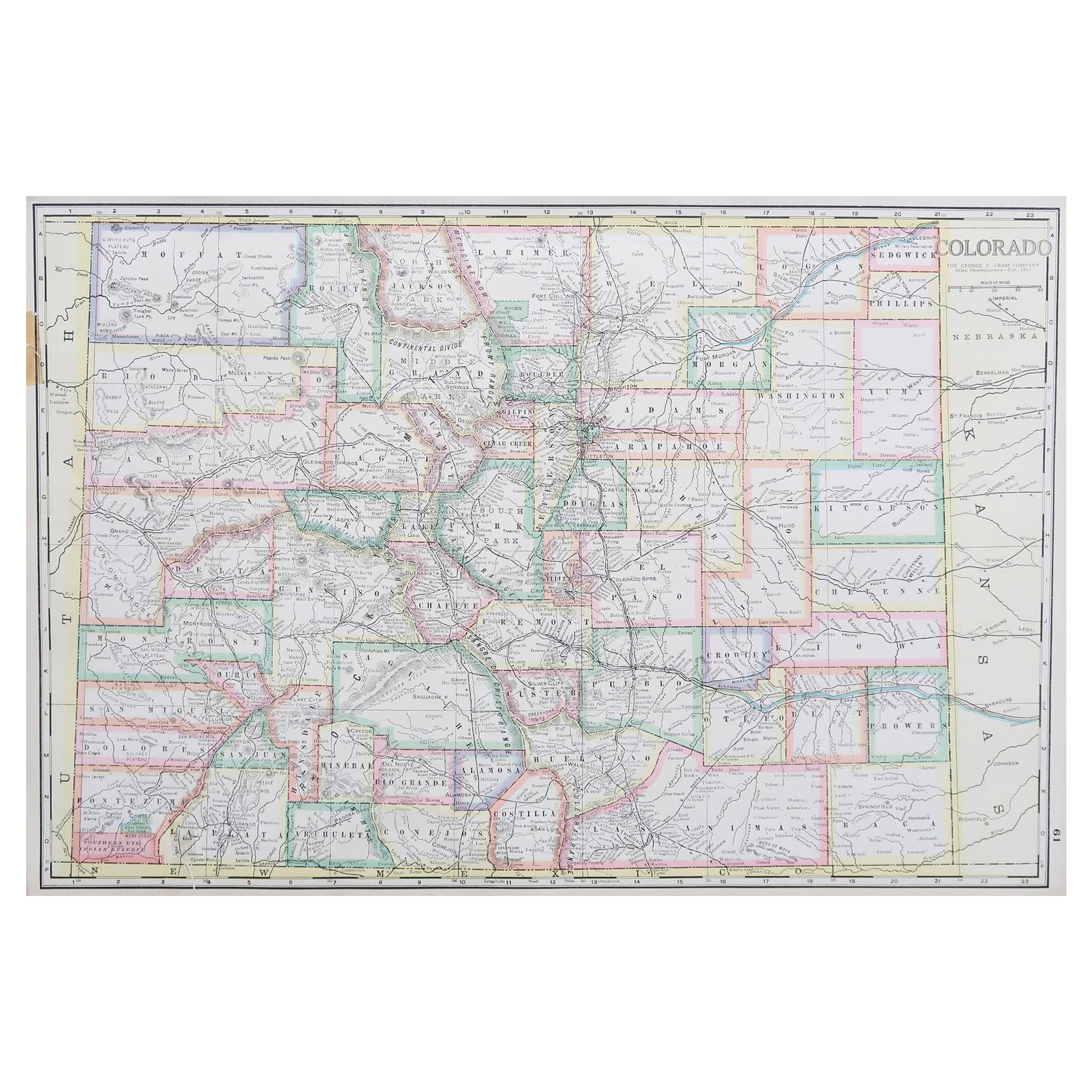
- Large Original Antique Map of Colorado, USA circa 1900Located in St Annes, LancashireFabulous map of Colorado Original color Engraved and printed by the George F. Cram Company, Indianapolis. Published, circa 1900 Unframed Old repairs to short trears on left and ...Category
Antique 1890s American Maps
MaterialsPaper
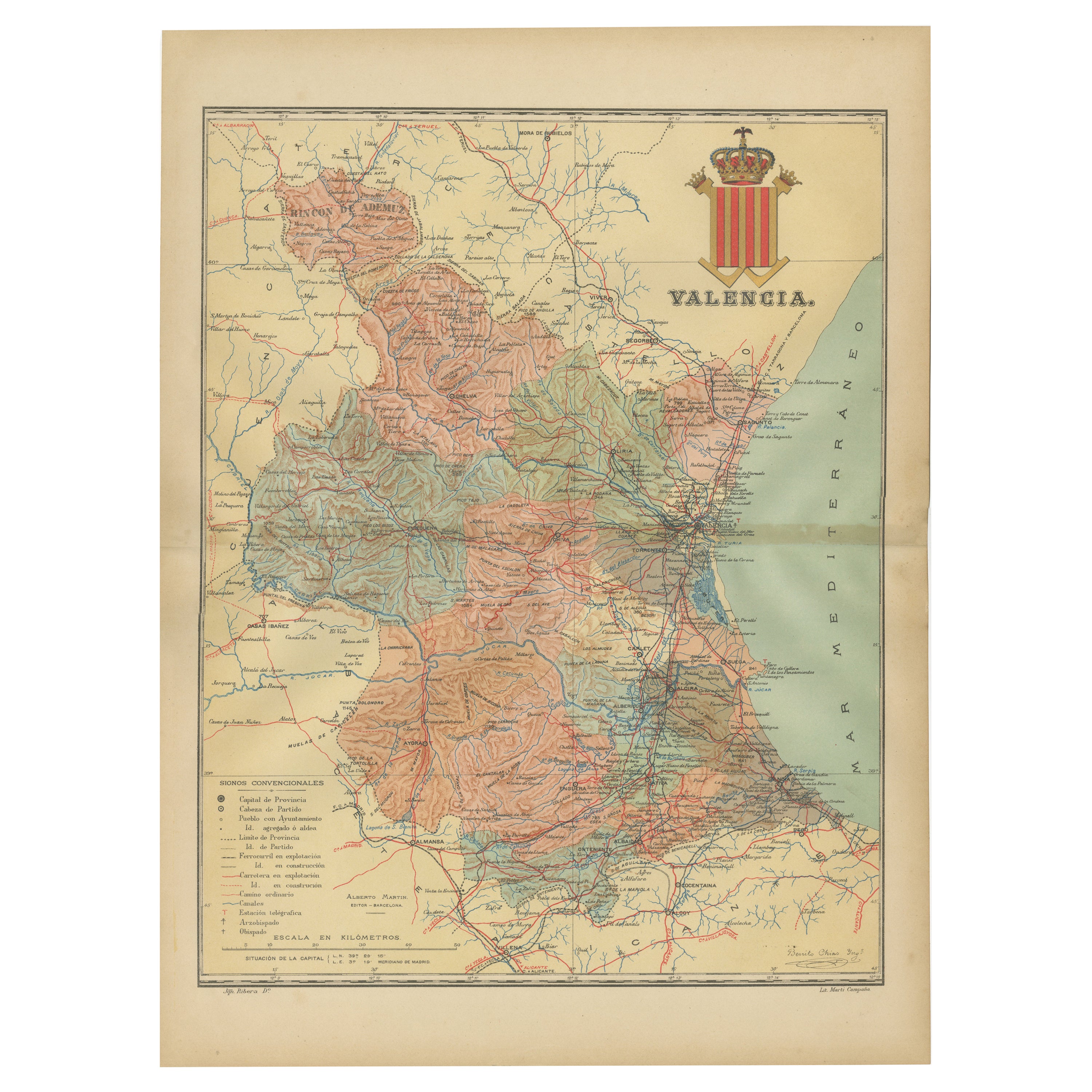
- Topographical and Infrastructure Map of the Province of Valencia, 1901Located in Langweer, NLA historical map of the province of Valencia, dated 1901. The map includes intricate details such as topographical features, with mountain ranges and river systems prominently marked...Category
Antique Early 1900s Maps
MaterialsPaper
- Antique Map of California, Utah, Nevada, Colorado, New Mexico & Arizona '1872'Located in Langweer, NLAntique map titled 'Johnson's California (..)'. Original map of California, Utah, Nevada, Colorado, New Mexico and Arizona. This map originates from ...Category
Antique Late 19th Century Maps
MaterialsPaper
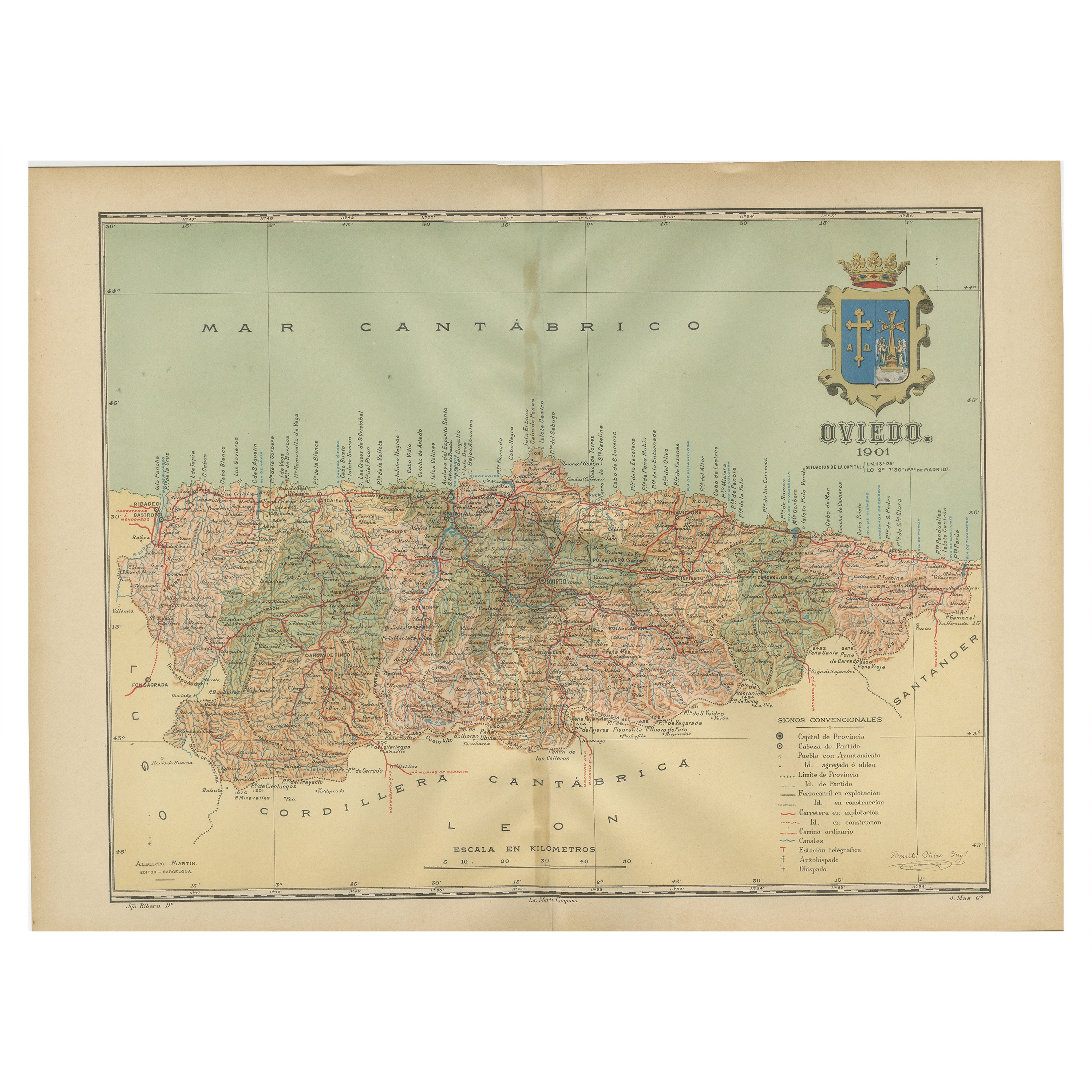
- The Lay of the Land: A 1901 Topographic Map of Oviedo, AsturiasLocated in Langweer, NLThe province depicted on the historical map on offer, Oviedo, corresponds to the modern-day autonomous community of Asturias in northwestern Spain. Here are some points about Asturia...Category
Antique Early 1900s Maps
MaterialsPaper
- Orense in Depth: A 1902 Topographical Map of Galicia's Mountainous ProvinceLocated in Langweer, NLThe map is a detailed cartographic representation of the province of Orense (Ourense in Galician), located in the northwest of Spain, as it was in 1902. Here's a brief description an...Category
Antique Early 1900s Maps
MaterialsPaper
- 17th Century Toulouse, Savve, Sommieres Topographical Map by Iohan PeetersLocated in New York, NYFine topographical 17th century map of Toulouse, Savve and Sommieres by Iohan Peeters Beautiful engraving of the capital of France's Occitanie Region, Toulouse, called La Ville Rose- the Pink City, for the terracotta bricks used in its many buildings, giving the city a distinct apricot-rose hue. An important cultural and educational center, the city's residents included Nobel Prize winners and world renown artists- Henri de Toulouse-Lautrec, Henri Martin, Jean-Auguste-Dominique Ingres, Antonin Mercie, Alexandre Falguiere and more recently Cyril Kongo...Category
Antique 17th Century Dutch Maps
MaterialsPaper


Recently Viewed
View AllMore Ways To Browse
Antique Map Prints
Antique Maps Prints
Antique Maps And Prints
Antique Prints And Maps
Folding Maps
Colorado Furniture
United States Map
Map Of United States
The United States Map
Colorado Used Furniture
Antique Town Maps
Framed Map
Antique Maps Book
Antique Map Framing
Antique Maps Framed
Framing Antique Maps
Antique State Maps
Antique Colorado