Items Similar to Antique Map of Dutch Cities Haarlem, Zandvoort, Bloemendaal, Wijk aan Zee, 1884
Want more images or videos?
Request additional images or videos from the seller
1 of 5
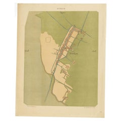
Antique Map of Dutch Cities Haarlem, Zandvoort, Bloemendaal, Wijk aan Zee, 1884
About the Item
Antique map titled 'Haarlem en Omstreken'. Old map of the region of Haarlem also including cities and villages like Wijk aan Zee, Beverwijk, Bloemendaal and Zandvoort. This map orginates from 'Atlas behoorende bij Wandelingen door Nederland met Pen en Potlood'. Artists and Engravers: Author: J. Craandijk. Published by H.D. Tjeenk Willink, Haarlem.
Artist: Author: J. Craandijk. Published by H.D. Tjeenk Willink, Haarlem.
Condition: Good, general age-related toning. Minor defects from handling, please study image carefully.
Date: 1884
Overall size: 17.9 x 26.6 cm.
Image size: 10.4 x 15.6 cm.
We sell original antique maps to collectors, historians, educators and interior decorators all over the world. Our collection includes a wide range of authentic antique maps from the 16th to the 20th centuries. Buying and collecting antique maps is a tradition that goes back hundreds of years. Antique maps have proved a richly rewarding investment over the past decade, thanks to a growing appreciation of their unique historical appeal. Today the decorative qualities of antique maps are widely recognized by interior designers who appreciate their beauty and design flexibility. Depending on the individual map, presentation, and context, a rare or antique map can be modern, traditional, abstract, figurative, serious or whimsical. We offer a wide range of authentic antique maps for any budget.
- Dimensions:Height: 10.48 in (26.6 cm)Width: 7.05 in (17.9 cm)Depth: 0 in (0.01 mm)
- Materials and Techniques:
- Period:
- Date of Manufacture:1884
- Condition:
- Seller Location:Langweer, NL
- Reference Number:
About the Seller
5.0
Platinum Seller
These expertly vetted sellers are 1stDibs' most experienced sellers and are rated highest by our customers.
Established in 2009
1stDibs seller since 2017
1,965 sales on 1stDibs
Typical response time: <1 hour
- ShippingRetrieving quote...Ships From: Langweer, Netherlands
- Return PolicyA return for this item may be initiated within 14 days of delivery.
More From This SellerView All
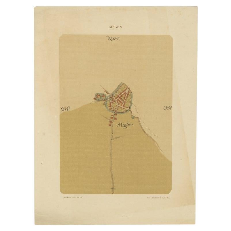
- Old Map of the Dutch City of Megen in Holland, 1916Located in Langweer, NLAntique map Megen titled 'Megen'. Antique map depicting the city of Megen, Noord-Brabant, The Netherlands. Artists and Engravers: Lithograph by J. Smulders & Co, Den Haag. Con...Category
20th Century Maps
MaterialsPaper
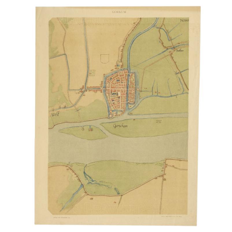
- Antique Map of The Dutch City of Gorinchem by Smulders, Lithograph, 1916Located in Langweer, NLAntique map Gorinchem titled 'Gorkum'. Antique map depicting the city of Gorinchem, The Netherlands. Artists and Engravers: Lithograph by J. Smulders & Co, Den Haag. Condition...Category
20th Century Maps
MaterialsPaper
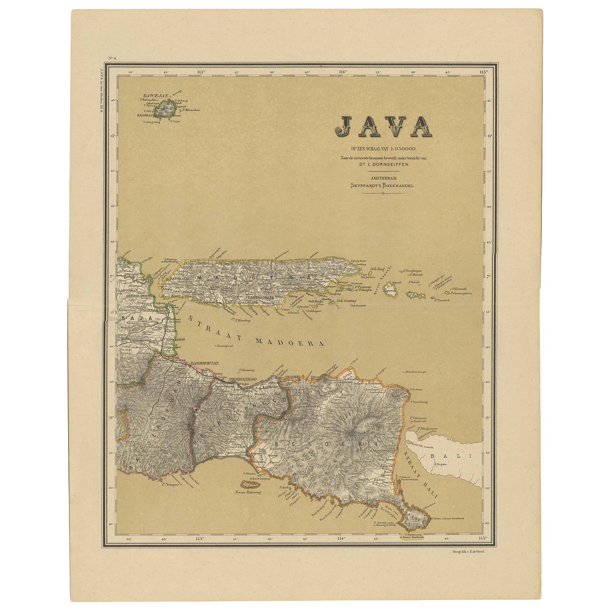
- Antique Map of Java in 4 sheets by Dornseiffen, 1884Located in Langweer, NLDetailed map of Java in 4 sheets, with an inset map of Batavia (Jakarta). This map originates from 'Atlas van Nederlandsch Oost- en West-Indie' by Dr. I. Dornseiffen. Published by Se...Category
Antique Late 19th Century Maps
MaterialsPaper
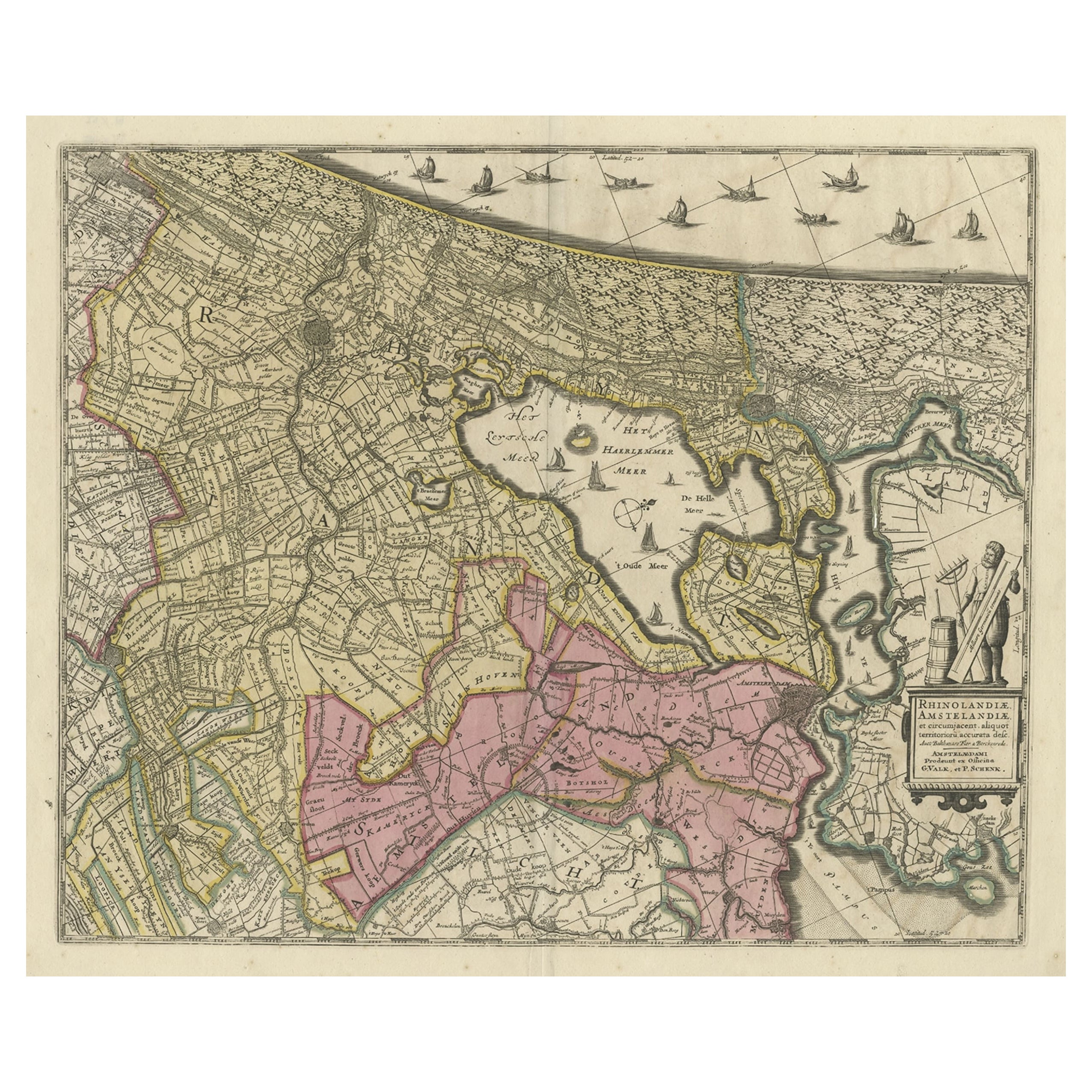
- Original Antique Map of the Netherlands Incl Amsterdam, Leiden and Haarlem, 1700Located in Langweer, NLAntique map titled ‘Rhinolandiae Amsterlandiae et circumjacent (..)’. Map of the regions of Rijnland and Amstelland in the Netherlands, including the cities of Amsterdam, Leiden ...Category
Antique Early 1700s Maps
MaterialsPaper
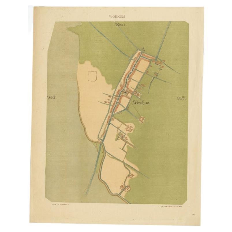
- Old Map of The Frisian City of Workum in Holland, 1916Located in Langweer, NLAntique map Workum titled 'Workum'. Antique map depicting the Frisian city of Workum, the Netherlands. Artists and Engravers: Lithograph by J. Smulders & Co, Den Haag. Condi...Category
20th Century Maps
MaterialsPaper
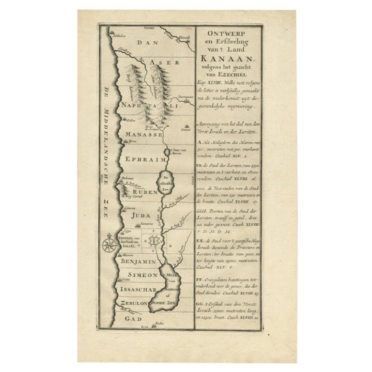
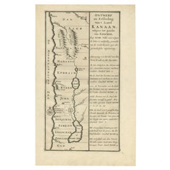
- Antique Uncommon Dutch Map of Ancient Israel, c.1730Located in Langweer, NLAntique map titled 'Ontwerp en Erfdeeling van't Land Kanaan, volgens het gezicht van Ezechiel.' Uncommon map of ancient Israel. This map shows Israel fr...Category
Antique 18th Century Maps
MaterialsPaper


You May Also Like
- Original Antique Map / City Plan of Brussels by Tallis, circa 1850Located in St Annes, LancashireGreat map of Brussels. Steel engraving. Published by London Printing & Publishing Co. (Formerly Tallis), C.1850 Free shipping.Category
Antique 1850s English Maps
MaterialsPaper
- Dutch Map and City Plan of La Roche-sur-Foron, France, 17th Century Hand ColoredBy Coenraet DeckerLocated in Alamo, CA"Rupes Allobrogum vulgo La Roche" by Dutch engraver Coenraet Decker (1650-1685) is from the atlas Theatrum Statuum Regiae Celestudinis Sabaudiae Ducis, published in 1682. This richly...Category
Antique Late 17th Century Dutch Maps
MaterialsPaper
- Antique Map of Principality of MonacoBy Antonio Vallardi EditoreLocated in Alessandria, PiemonteST/619 - "Old Geographical Atlas of Italy - Topographic map of ex-Principality of Monaco" - ediz Vallardi - Milano - A somewhat special edition ---Category
Antique Late 19th Century Italian Other Prints
MaterialsPaper
- Original Antique Map of India. C.1780Located in St Annes, LancashireGreat map of India Copper-plate engraving Published C.1780 Three small worm holes to right side of map and one bottom left corner Unframed.Category
Antique Early 1800s English Georgian Maps
MaterialsPaper

- Original Antique Map of Asia. C.1780Located in St Annes, LancashireGreat map of Asia Copper-plate engraving Published C.1780 Two small worm holes to right side of map Unframed.Category
Antique Early 1800s English Georgian Maps
MaterialsPaper

- Original Antique Map of Italy. C.1780Located in St Annes, LancashireGreat map of Italy Copper-plate engraving Published C.1780 Unframed.Category
Antique Early 1800s English Georgian Maps
MaterialsPaper


Recently Viewed
View AllMore Ways To Browse
1884 Collection
World Map Globe
Antique Furniture Rollers
Swiss Antiques And Collectables
Antique Roman Map
Antique School Map
Antique School Maps
East India Map
Map Hondius
Antique Maps South America
Ireland Antiques
16th Century Pay
Vans Coat Of Arms
Antique Map Of South America
Atlas Globe
Roman Map
Map Of Austria
United States Map Vintage