Items Similar to Antique Map of Northern Africa by Perthes, 1848


Want more images or videos?
Request additional images or videos from the seller
1 of 5
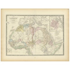
Antique Map of Northern Africa by Perthes, 1848
About the Item
Antique map titled 'Africa Propria (..)'. Old map of North Africa and the region of Babylon originating from 'Orbis Terrarum Antiquus in usum Scholarum'. Artists and Engravers: Published by Justus Perthes, 1848.
Artist: Published by Justus Perthes, 1848.
Condition: Good, general age-related toning. Minor defects, please study image carefully.
Date: 1848
Overall size: 31.8 x 24.8 cm.
Image size: 0.001 x 22.7 x 17.8 cm.
Antique prints have long been appreciated for both their aesthetic and investment value. They were the product of engraved, etched or lithographed plates. These plates were handmade out of wood or metal, which required an incredible level of skill, patience and craftsmanship. Whether you have a house with Victorian furniture or more contemporary decor an old engraving can enhance your living space.
- Dimensions:Height: 9.77 in (24.8 cm)Width: 12.52 in (31.8 cm)Depth: 0 in (0.01 mm)
- Materials and Techniques:
- Period:
- Date of Manufacture:1848
- Condition:
- Seller Location:Langweer, NL
- Reference Number:
About the Seller
5.0
Platinum Seller
These expertly vetted sellers are 1stDibs' most experienced sellers and are rated highest by our customers.
Established in 2009
1stDibs seller since 2017
1,965 sales on 1stDibs
Typical response time: <1 hour
- ShippingRetrieving quote...Ships From: Langweer, Netherlands
- Return PolicyA return for this item may be initiated within 14 days of delivery.
More From This SellerView All
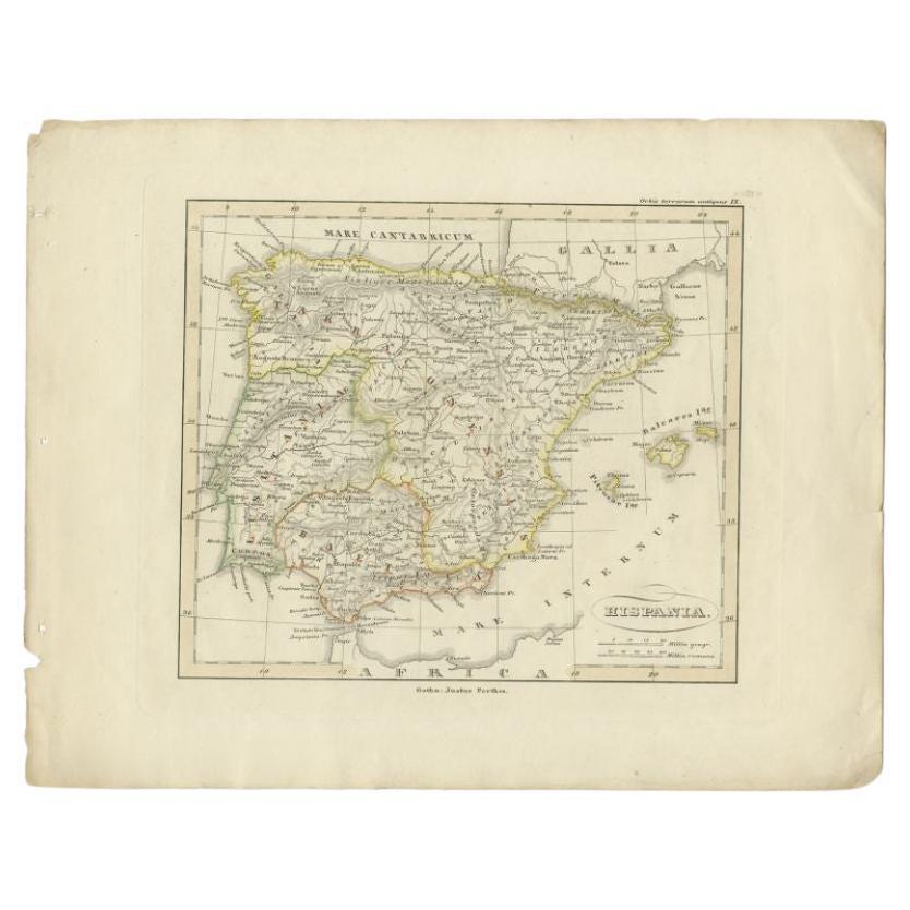
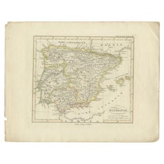
- Antique Map of Spain by Perthes, 1848Located in Langweer, NLAntique map titled 'Hispania'. Old map of Spain originating from 'Orbis Terrarum Antiquus in usum Scholarum'. Artists and Engravers: Published by Justus P...Category
Antique 19th Century Maps
MaterialsPaper
- Antique Map of the Middle East by Perthes, 1848Located in Langweer, NLAntique map titled 'Terra inter Euphratem et Indum Antiqua'. Old map of the Middle East originating from 'Orbis Terrarum Antiquus in usum Schola...Category
Antique 19th Century Maps
MaterialsPaper
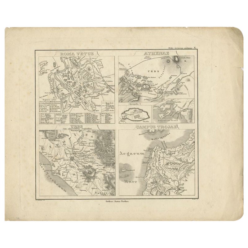
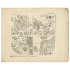
- Antique Map of Rome and Athens by Perthes, 1848Located in Langweer, NLAntique map titled 'Roma Vetus, Athenae, Urbs, Campus Trojae'. Old map of Rome, Athens and surroundings originating from 'Orbis Terrarum Antiquus in usum S...Category
Antique 19th Century Maps
MaterialsPaper
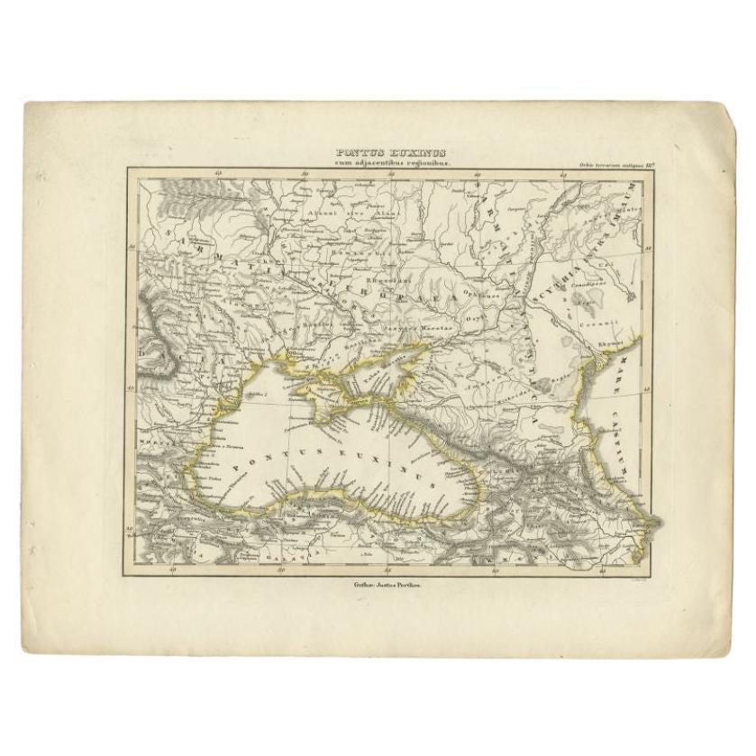
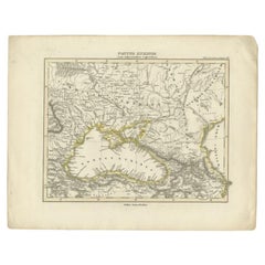
- Antique Map of the Black Sea by Perthes, 1848Located in Langweer, NLAntique map titled 'Pontus Euxinus'. Old map of the Black Sea and surroundings originating from 'Orbis Terrarum Antiquus in usum Scholarum'. Artists and Engravers: Published by Justu...Category
Antique 19th Century Maps
MaterialsPaper
- Antique Map of Northern Africa by Levasseur, '1875'Located in Langweer, NLAntique map titled 'Carte de l'Afrique Septentrionale'. Large map of Northern Africa. This map originates from 'Atlas de Géographie Moderne Physique et...Category
Antique Late 19th Century Maps
MaterialsPaper
- Original Antique Map of Northern Africa by Van Dùren (1749)Located in Langweer, NLThis is a German antique map titled 'Neue Geographische Vorstellung der Mitternaechtlichen Küste von Africa'. Original antique engraving of Northern Africa extending from the Strait ...Category
Antique Mid-18th Century Maps
MaterialsPaper


You May Also Like
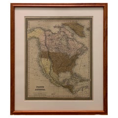
- Large 1848 North America & Territories MapLocated in Stamford, CTFramed 1848 S. Augustus and Mitchell, Philadelphia , PA North America and territories map. Featuring the United States, Canada (British Territory) and Mexican Territories. As found...Category
Antique 1840s American American Classical Maps
MaterialsGlass, Wood, Paper
- Original Antique Map of South Africa, Arrowsmith, 1820Located in St Annes, LancashireGreat map of South Africa. Drawn under the direction of Arrowsmith. Copper-plate engraving. Published by Longman, Hurst, Rees, Orme and Br...Category
Antique 1820s English Maps
MaterialsPaper
- London 1744 Published Watercolour Antique Map of East Africa by Eman BowenLocated in GBWe are delighted to offer for sale this New and Accurate Map of Nubia & Abissinia, together with all the Kingdoms Tributary Thereto, and bordering upon them published in 1744 by Emanuel Bowen This is a decorative antique engraved map of East Africa...Category
Antique 1740s English George III Maps
MaterialsPaper
- Large University Chart “Physical Map of Africa” by BaconLocated in Chillerton, Isle of WightLarge university chart “Physical Map of Africa” by Bacon W&A K Johnston’s Charts of Physical Maps By G W Bacon, This is colorful Physical map of North America, it is large lithograph set...Category
Early 20th Century Folk Art Posters
MaterialsLinen
- 1861 Topographical Map of the District of Columbia, by Boschke, Antique MapLocated in Colorado Springs, COPresented is an original map of Albert Boschke's extremely sought-after "Topographical Map of the District of Columbia Surveyed in the Years 1856 ...Category
Antique 1860s American Historical Memorabilia
MaterialsPaper
- Antique Lithography Map, West Africa, English, Framed, Cartography, VictorianLocated in Hele, Devon, GBThis is an antique lithography map of Western Africa. An English, framed atlas engraving of cartographic interest by John Rapkin, dating to the early Victorian period and later, circ...Category
Antique Mid-19th Century British Early Victorian Maps
MaterialsWood


Recently Viewed
View AllMore Ways To Browse
Victorian Furniture
Used Victorian Furniture
Victorian Antique Furniture
Antique Victorian Furniture
African Antique Wood
African Plate
North Africa Map
Babylon Map
Map Tapestry
18th Century Globe Of The World
American Empire Antiques
Large Antique Compass
Egyptian Authentic Furniture
Map Of Vienna
Vienna Map
Nile River
Treasure Map
Antique Map Mexico