Items Similar to Attractive Original Hand-Colored Map of the Swabia Region of Germany, 1799


Want more images or videos?
Request additional images or videos from the seller
1 of 5
Attractive Original Hand-Colored Map of the Swabia Region of Germany, 1799
About the Item
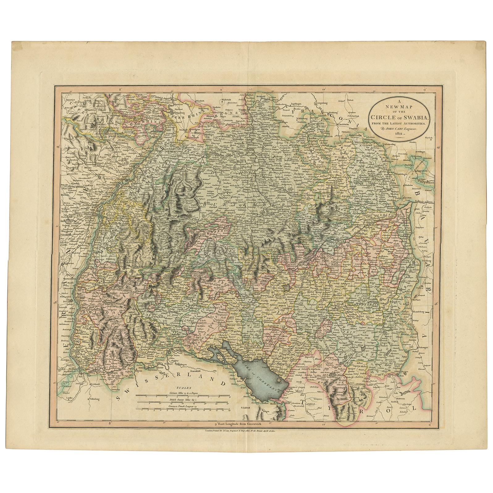
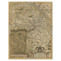
Antique map titled 'A New Map of the Circle of Swabia, from the Latest Authorities'.
Attractive example of John Cary's 1799 map of the Swabia region of Germany. Covers from the Upper Rhine region south as far as Switzerland, Lake Constance and Tyrol. Extends eastward as far as Bavaria and westward as far as France. Includes the Black Forest region and the Duchy of Wurtenburg (Stuttgart). Highly detailed with color coding according to region. Shows forests, cities, palaces, forts, roads and rivers. This map orginates from 'New Universal Atlas, containing distinct maps of all the principal states and kingdoms throughout the Worl' by John Cary.
Artists and Engravers: John Cary (1754 - 1835) was a London based cartographer active in the early part of the 19th century. Cary began his work as an engraver, cartographer, and globe maker in 1776 with his New and Correct English Atlas. This important atlas represented a new phase in cartography where accuracy and detail rose in prominence over the decorative embellishments of the 18th century. This change was indicative of the times when travel and commerce were expanding globally as never before. Cary's mastery of both engraving and cartography resulted in a series of seminal works that redefined mapmaking in the early 19th century. His stupendous Cary's New Universal Atlas, published in 1808, set the standard for all cartographers who followed. Cary reissued this seminal atlas in 1811, 1819, 1824, 1828, 1833, 1836 and 1844. Cary also did considerable work on the English Ordinance Survey prior to 1805. His cartographic work particularly inspired the Edinburgh school of cartography as represented by John Pinkerton and John Thomson. In America, Cary's work was used as the basis for Tanner's important New American Atlas. Cary's last published atlas appeared posthumously in 1844, however, by 1850 Cary's work was being carried on by his sons and other well-known cartographers including James Wyld, John Tallis & Company, and Crutchley.
Condition: Good, given age. Original/contemporary hand coloring. Some crinkles and soft creases. Bottom edge with two small tears, not affecting image. Original middle fold as issued. General age-related toning and/or occasional minor defects from handling. Blank verso. Please study scan carefully.
- Dimensions:Height: 19.97 in (50.7 cm)Width: 23.23 in (59 cm)Depth: 0 in (0.02 mm)
- Materials and Techniques:
- Period:1790-1799
- Date of Manufacture:1799
- Condition:Wear consistent with age and use. Condition: Good, given age. Original/contemporary hand coloring. Some crinkles and soft creases. Bottom edge with two small tears, not affecting image. Original middle fold as issued. General age-related toning and/or occasional minor defects from ha.
- Seller Location:Langweer, NL
- Reference Number:
About the Seller
5.0
Platinum Seller
These expertly vetted sellers are 1stDibs' most experienced sellers and are rated highest by our customers.
Established in 2009
1stDibs seller since 2017
1,965 sales on 1stDibs
Typical response time: <1 hour
- ShippingRetrieving quote...Ships From: Langweer, Netherlands
- Return PolicyA return for this item may be initiated within 14 days of delivery.
More From This SellerView All
- Antique Map of the Swabia Region of Germany by Cary, '1811'By John CaryLocated in Langweer, NLAntique map titled 'A New Map of the Circle of Swabia'. Antique map of Swabia in Southwestern Germany. Covers from the Upper Rhine region south as far as Switzerland, Lake Constance ...Category
Antique Early 19th Century Maps
MaterialsPaper
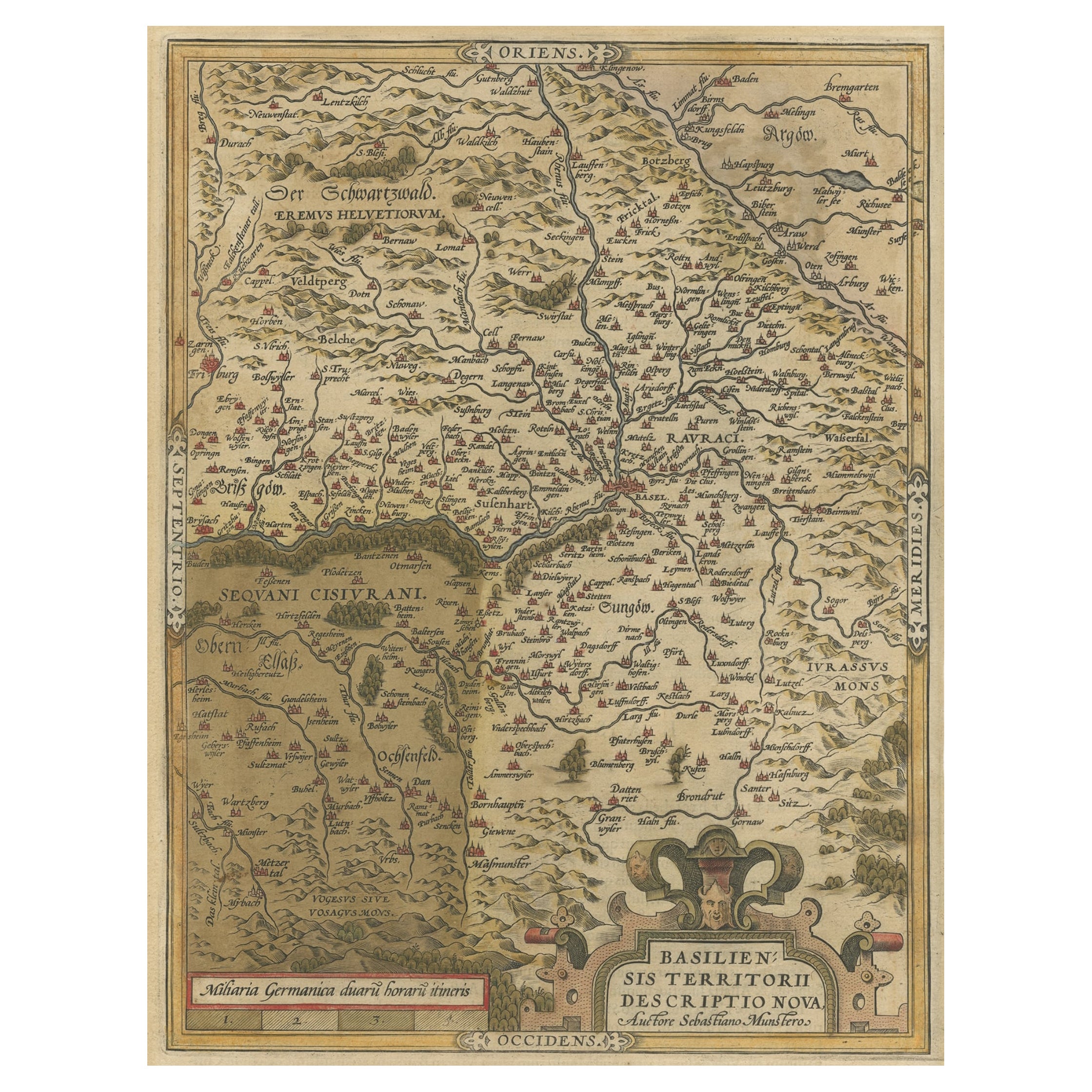
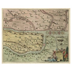
- Very Old Original Hand-Colored Map of the Basel Region, Switzerland, Ca.1578Located in Langweer, NLAntique print titled 'Basiliensis territorii descriptio nova'. Old map of the Basel region, Switzerland. Originates from 'Theatrum Orbis Terrarum' by A. Ortelius. Artists and...Category
Antique 16th Century Maps
MaterialsPaper
- Antique Map of the Region of Oldenburg, GermanyBy Willem BlaeuLocated in Langweer, NLAntique map titled 'Oldenburg Comitatus'. Detailed old map of Oldenburg, Germany. The map also shows Bremen and the Jade Bight. Published by W. Blaeu, circa 1640. Willem Jansz. Blaeu...Category
Antique Mid-17th Century Maps
MaterialsPaper
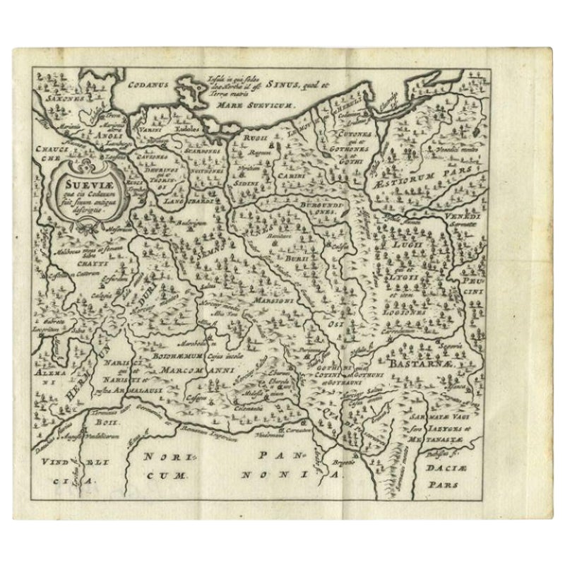
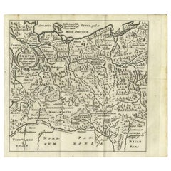
- Antique Map of Swabia, 1685Located in Langweer, NLAntique map titled 'Sueviae quae cis Codanum fuit finum Antiqua defcriptio.' Miniature map of Swabia, a medieval Duchy in south-west Germany, that also included part of Poland, from ...Category
Antique 17th Century Maps
MaterialsPaper
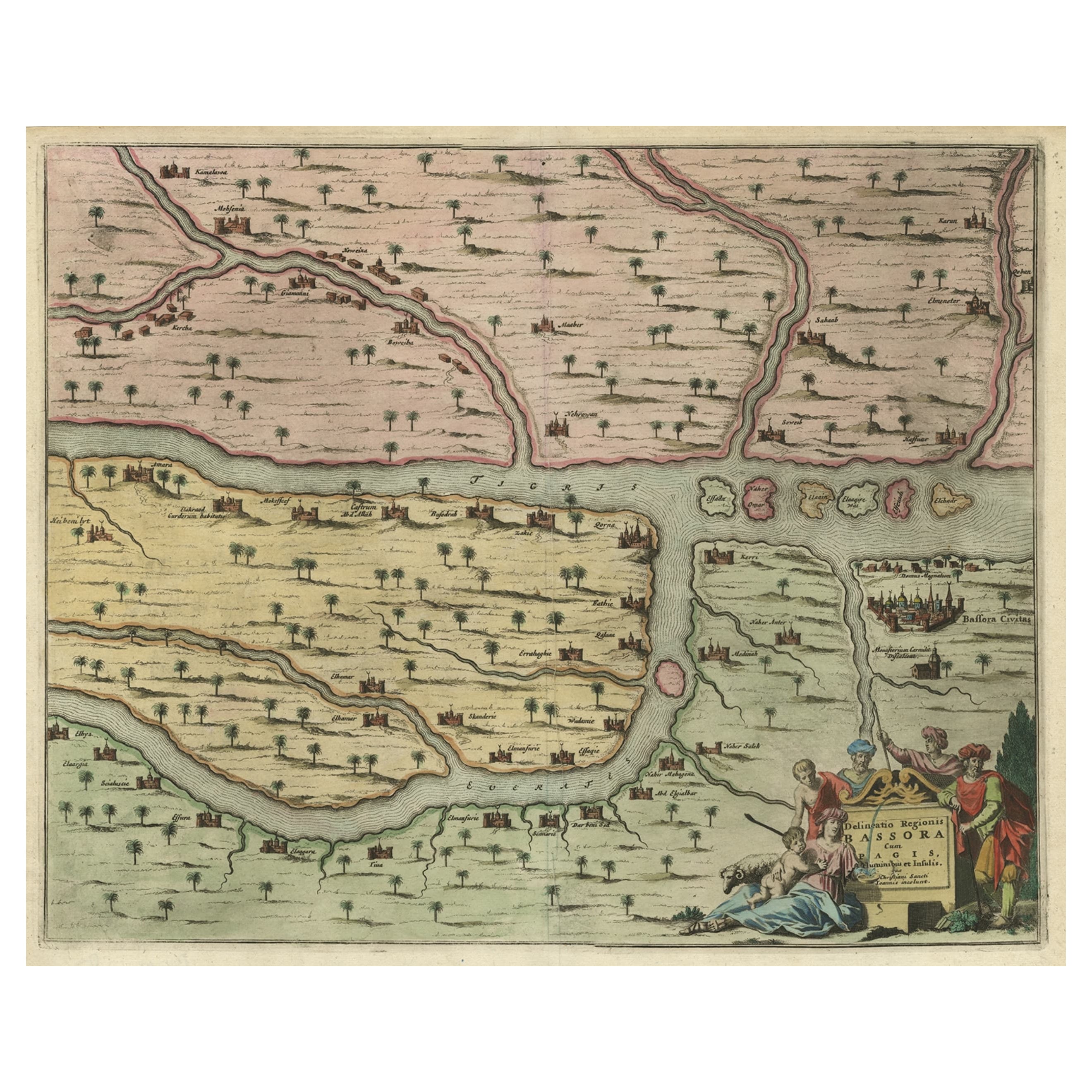
- Rare Hand-Colored Antique Map of the Bassora 'Basra' Region in Iraq, 1680Located in Langweer, NLDescription: Antique map titled 'Delineato Regionis Bassora cum Angis uminibus et Isulis.' Map of the Bassora (Basra) region, Iraq. Artists and Engravers: Made by 'Olfert Dapper' ...Category
Antique 1680s Maps
MaterialsPaper
- Original Antique Map of the Northern Baltic RegionLocated in Langweer, NLTitle: "Livonia: Antique Map of the Northern Baltic Region" Description: This antique map, titled "Livonia," is a detailed representation of the northern Baltic region. Centered on ...Category
Antique Early 17th Century Maps
MaterialsPaper


You May Also Like
- 17th Century Hand-Colored Map of a Region in West Germany by JanssoniusBy Johannes JanssoniusLocated in Alamo, CAThis attractive highly detailed 17th century original hand-colored map is entitled "Archiepiscopatus Maghdeburgensis et Anhaltinus Ducatus cum terris adjacentibus". It was published ...Category
Antique Mid-17th Century Dutch Maps
MaterialsPaper
- The Normandy Region of France: A 17th C. Hand-colored Map by Sanson and JaillotBy Nicolas SansonLocated in Alamo, CAThis large hand-colored map entitled "Le Duché et Gouvernement de Normandie divisée en Haute et Basse Normandie en divers Pays; et par evêchez, avec le Gouvernement General du Havre ...Category
Antique 1690s French Maps
MaterialsPaper
- 17th Century Hand Colored Map of the Liege Region in Belgium by VisscherBy Nicolaes Visscher IILocated in Alamo, CAAn original 17th century map entitled "Leodiensis Episcopatus in omnes Subjacentes Provincias distincté divisusVisscher, Leodiensis Episcopatus" by Nicolaes Visscher II, published in Amsterdam in 1688. The map is centered on Liege, Belgium, includes the area between Antwerp, Turnhout, Roermond, Cologne, Trier and Dinant. This attractive map is presented in a cream-colored mat measuring 30" wide x 27.5" high. There is a central fold, as issued. There is minimal spotting in the upper margin and a tiny spot in the right lower margin, which are under the mat. The map is otherwise in excellent condition. The Visscher family were one of the great cartographic families of the 17th century. Begun by Claes Jansz Visscher...Category
Antique Late 17th Century Dutch Maps
MaterialsPaper
- Germany West of the Rhine: A Hand-colored 18th Century Map by de WitBy Frederick de WitLocated in Alamo, CAThis original 18th century hand-colored map of the county of Moers, Germany entitled "Illustrissimo Celsissmo Principi GUILIELMO HENRICO D.G. Arausionum Principi Domino suo Clementis...Category
Antique Early 18th Century Dutch Maps
MaterialsPaper
- 18th Century Hand-Colored Homann Map of Germany, Including Frankfurt and BerlinBy Johann Baptist HomannLocated in Alamo, CAAn 18th century hand-colored map entitled "Tabula Marchionatus Brandenburgici et Ducatus Pomeraniae quae sunt Pars Septentrionalis Circuli Saxoniae Superioris" by Johann Baptist Homa...Category
Antique Early 18th Century German Maps
MaterialsPaper
- City View of Nuremberg, Germany: An 18th Century Hand-Colored Map by M. SeutterBy Matthew SeutterLocated in Alamo, CAAn 18th century hand-colored city view of Nuremburg, Germany entitled "Geometrischer Grundris der des Heiligen Römischen Reichs Freyen Stadt Nürnberg" by Matthaus Seutter from his "A...Category
Antique Mid-18th Century German Maps
MaterialsPaper


Recently Viewed
View AllMore Ways To Browse
Map Of South America
French Map Of America
Hand Colored Engraving Set
Map Of South Of France
Set Of Hand Colored Engravings
Map Of Switzerland
1790 America
18th Century Maps America
Antique Map Of The South Of France
Antique Globes 18th Century
James River Furniture
Antique Map Of Switzerland
Antique Map Switzerland
18th Century French Globe
Maps Tallis
John Tallis Map
Rhine River
Antique Engravings Globe