Items Similar to Decorative Map of the French Regions of Picardy, Artois & French Flanders, c1780
Want more images or videos?
Request additional images or videos from the seller
1 of 5
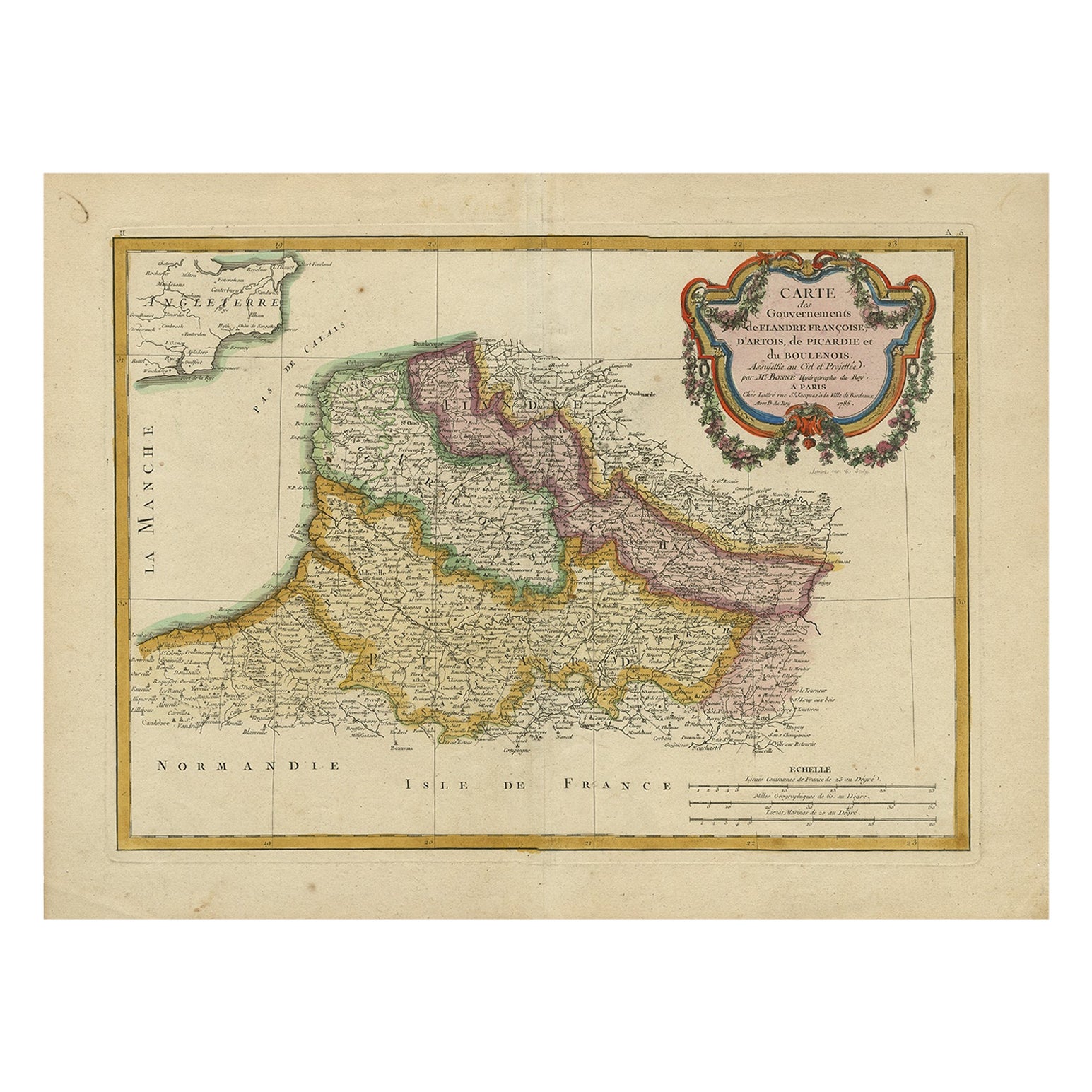
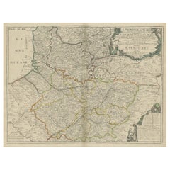
Decorative Map of the French Regions of Picardy, Artois & French Flanders, c1780
About the Item
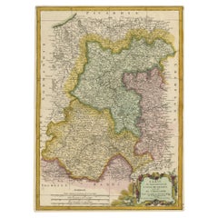
Antique map titled 'Carte des Gouvernements de Flandre Francoise, d'Artois, de Picardie et du Boulenois.'
An attractive example of Rigobert Bonne's 1771 decorative map of the French regions of Picardy, Artois, and French Flanders. Covers the region in full from the English Chanel to Normandy. A large decorative title cartouche appears in the upper right. Source unknown, to be determined.
Artists and Engravers: Rigobert Bonne (1727-1795 ) was one of the most important cartographers of the late 18th century. In 1773 he succeeded Jacques Bellin as Royal Cartographer to France in the office of the Hydrographer at the Depôt de la Marine. Working in his official capacity Bonne compiled some of the most detailed and accurate maps of the period. Bonne's work represents an important step in the evolution of the cartographic ideology away from the decorative work of the 17th and early 18th century towards a more detail oriented and practical aesthetic. With regard to the rendering of terrain Bonne maps bear many stylistic similarities to those of his predecessor, Bellin. However, Bonne maps generally abandon such common 18th century decorative features such as hand coloring, elaborate decorative cartouches, and compass roses. While mostly focusing on coastal regions, the work of Bonne is highly regarded for its detail, historical importance, and overall aesthetic appeal.
- Dimensions:Height: 14.57 in (37 cm)Width: 19.49 in (49.5 cm)Depth: 0 in (0.02 mm)
- Materials and Techniques:
- Period:1780-1789
- Date of Manufacture:circa 1780
- Condition:Wear consistent with age and use. Condition: Fair, given age. A few soft creases and crinkles. A few small spots. Four tiny worm holes; backed. Original middle fold as issued. General age-related toning and/or occasional minor defects from handling. Please study image carefully.
- Seller Location:Langweer, NL
- Reference Number:
About the Seller
5.0
Platinum Seller
These expertly vetted sellers are 1stDibs' most experienced sellers and are rated highest by our customers.
Established in 2009
1stDibs seller since 2017
1,970 sales on 1stDibs
Typical response time: <1 hour
- ShippingRetrieving quote...Ships From: Langweer, Netherlands
- Return PolicyA return for this item may be initiated within 14 days of delivery.
More From This SellerView All
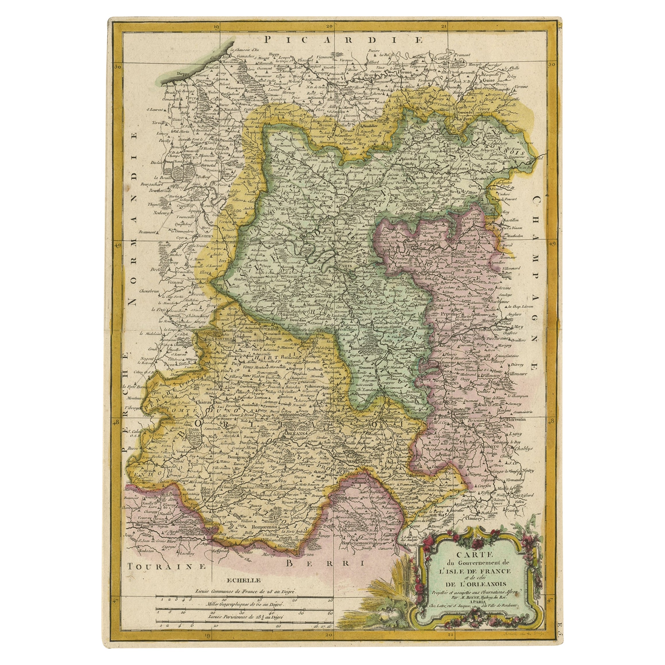
- Decorative Rare Map of the French Regions of Isle De France and Orleans, ca.1780Located in Langweer, NLAntique map titled 'Carte du Gouvernment de L'Isle de France et de edlui de L'Orleanois (..).' A fine example of Rigobert Bonne's c. 1780 decorative map of the French regions of ...Category
Antique 1780s Maps
MaterialsPaper
- Antique Map of Picardy, Aroits and French Flanders by Bonne, c.1780Located in Langweer, NLAntique map titled 'Carte des Gouvernements de Flandre Francoise, d'Artois, de Picardie et du Boulenois.' An attractive example of Rigobert Bonne's 1771 decorative map of the French regions of Picardy, Artois, and French Flanders. Covers the region in full from the English Chanel to Normandy. A large decorative title cartouche appears in the upper right. Source unknown, to be determined. Artists and Engravers: Rigobert Bonne (1727-1795 ) was one of the most important cartographers of the late 18th century. In 1773 he succeeded Jacques Bellin as Royal Cartographer to France in the office of the Hydrographer at the Depôt de la Marine. Working in his official capacity Bonne compiled some of the most detailed and accurate maps of the period. Bonne's work represents an important step in the evolution of the cartographic ideology away from the decorative work of the 17th and early 18th century towards a more detail oriented and practical aesthetic. With regard to the rendering of terrain Bonne maps...Category
Antique 18th Century Maps
MaterialsPaper
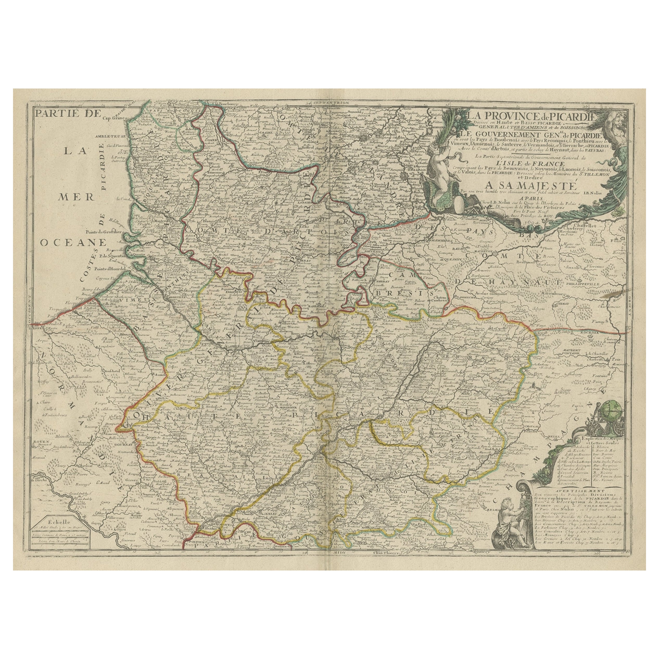
- Large Antique Map of the Picardy Region of France, 1694Located in Langweer, NLAntique map titled 'La Province de Picardie (..)'. Large map of the Picardy region of France. Shows the cities of Beaumont, Mondidier, Lille and others. Artists and Engravers...Category
Antique 1690s Maps
MaterialsPaper
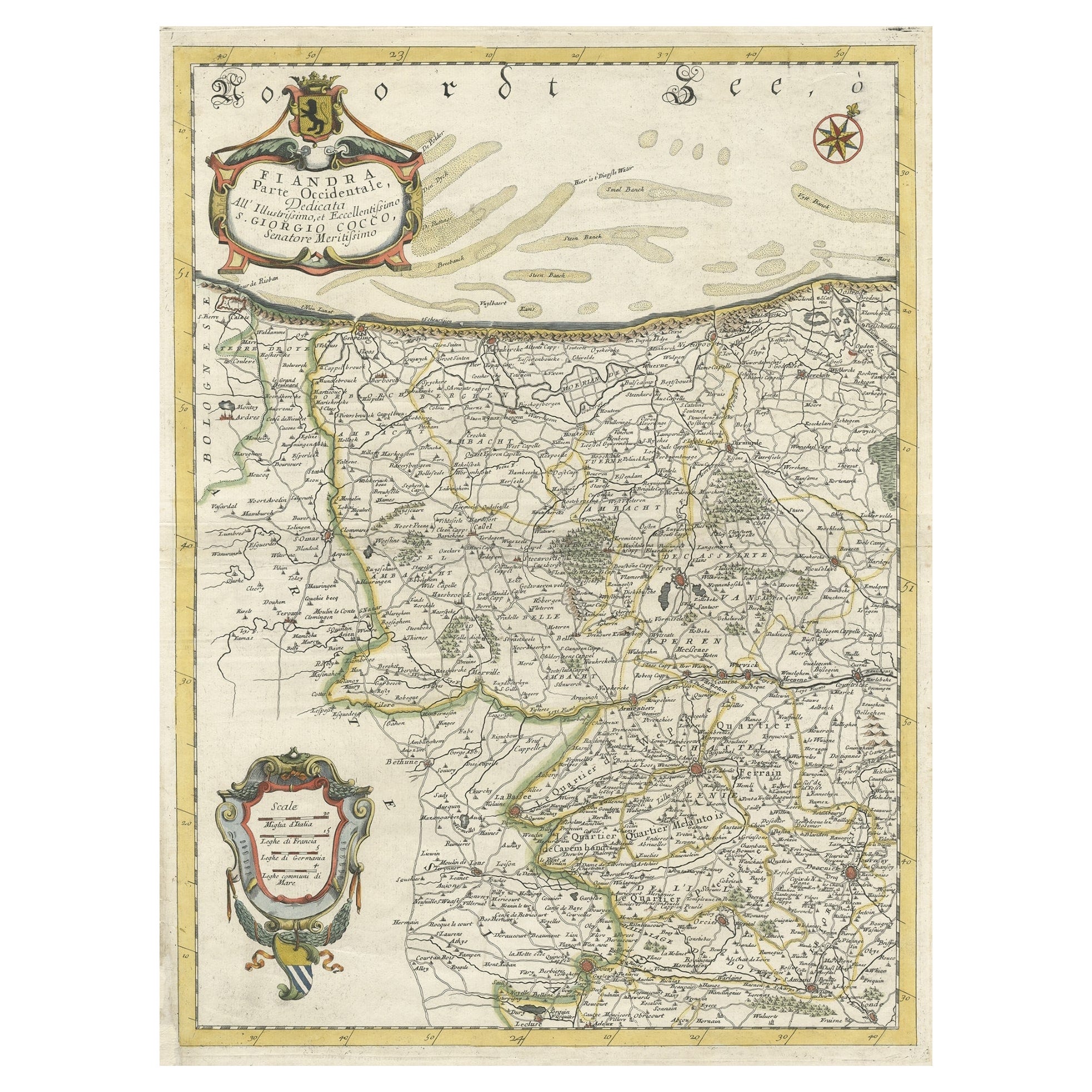
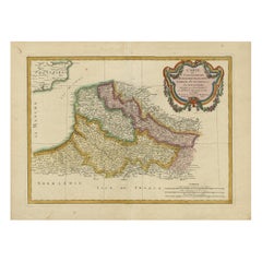
- Decorative Original Antique Map of the North of Flanders, Belgium, 1697Located in Langweer, NLAntique map titled 'Fiandra Parte Occidentale (..)'. Depicts northern part of Flanders, from North Sea, extends through the northern region of France to the cities of Douai and V...Category
Antique 1690s Maps
MaterialsPaper
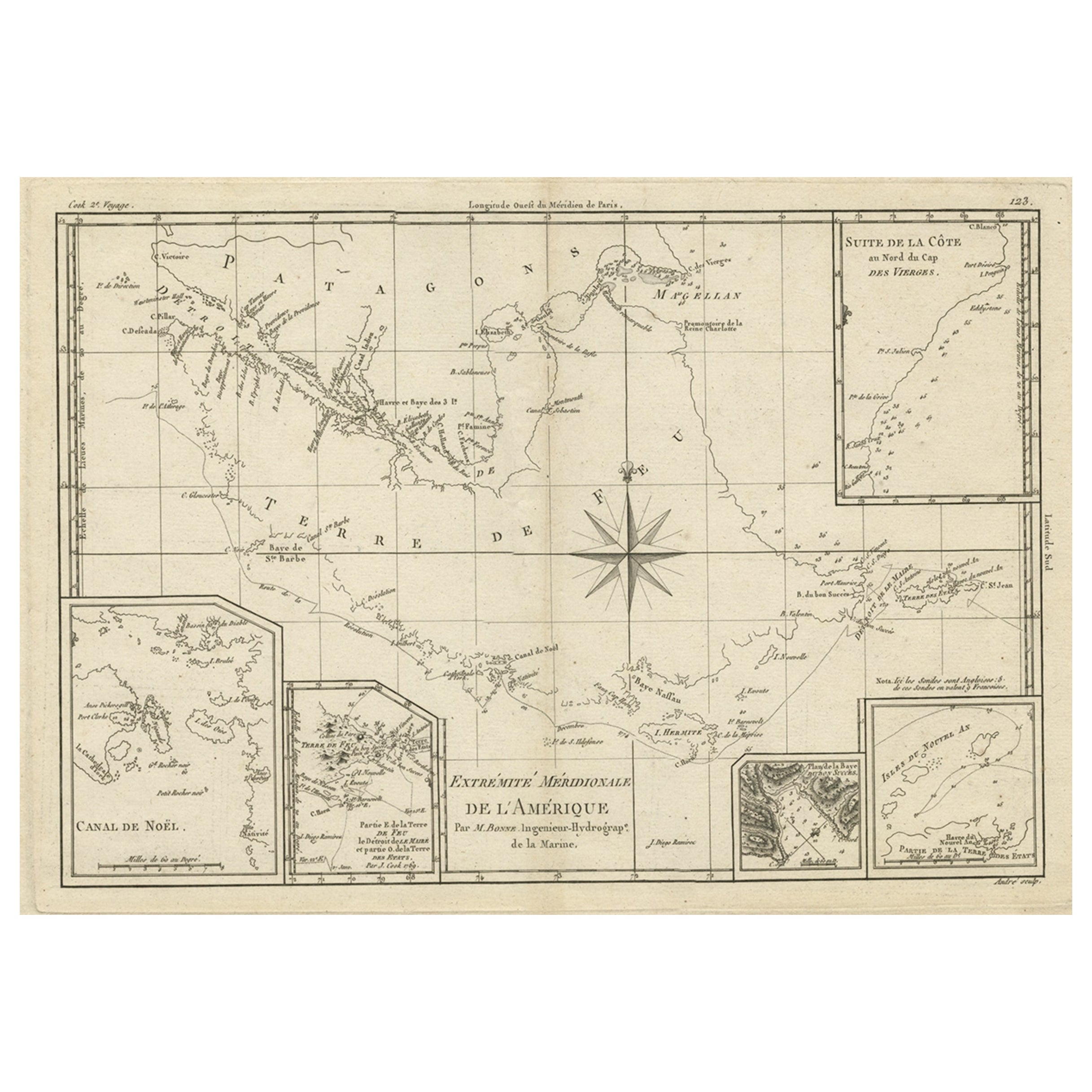
- Copper Engraved Map of Tierra del Fuego and the Strait of Magellan, c1780Located in Langweer, NLAntique map titled 'Extremite Meridionale de l'Amerique.' Copper engraved map of Tierra del Fuego and the Strait of Magellan with five detailed insets of the region showing soundings, anchorages, etc. Engraved by Andre. This map originates from 'Atlas de Toutes les Parties Connues du Globe Terrestre'. Artists and Engravers: Rigobert Bonne (1727-1795 ) was one of the most important cartographers of the late 18th century. In 1773 he succeeded Jacques Bellin as Royal Cartographer to France in the office of the Hydrographer at the Depôt de la Marine. Working in his official capacity Bonne compiled some of the most detailed and accurate maps of the period. Bonne's work represents an important step in the evolution of the cartographic ideology away from the decorative work of the 17th and early 18th century towards a more detail oriented and practical aesthetic. With regard to the rendering of terrain Bonne maps...Category
Antique 1780s Maps
MaterialsPaper
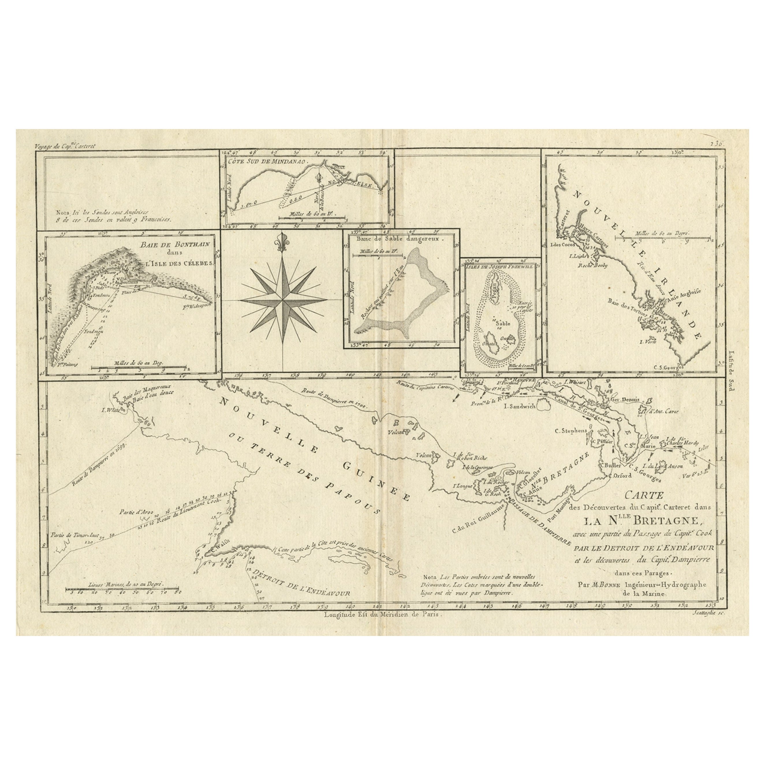
- Antique Detailed Map of Papua New Guinea and the Regions to the West, ca.1780Located in Langweer, NLAntique map titled 'Carte des Decouvertes du Capite. Carteret dans La Nlle. Bretagne avec une parte du passage du Capite. Cook Par Le Detroit De L'Endeavor ...Category
Antique 1780s Maps
MaterialsPaper
You May Also Like
- Antique 1630 Colored Belgium Map Flandria Gallica Flanders Henricus HondiusLocated in Dayton, OH"Antique hand colored map of Flanders, Belgium, circa 1630, engraved by Henricus Hondius. “Henricus Hondius II (1597 – 16 August 1651) was a Dutch eng...Category
Antique Early 17th Century Renaissance Maps
MaterialsPaper
- Map of the Republic of GenoaLocated in New York, NYFramed antique hand-coloured map of the Republic of Genoa including the duchies of Mantua, Modena, and Parma. Europe, late 18th century. Dimension: 25...Category
Antique Late 18th Century European Maps
- Map "Estuary- Mouth of the Thames"Located in Alessandria, PiemonteST/426 - Antique French Map of the estuary of the Thames, map dated 1769 - "Mape of the entrance of the Thames. Designed by filing of Navy cards fo...Category
Antique Mid-18th Century French Other Prints
MaterialsPaper
- Gilt Framed Vintage Wine Regions of France MapLocated in Alton, GBFramed French wine region map 1973. The print has been removed to clean the glass, the frame has minor damage in places but nothing that detracts from ...Category
Vintage 1970s French Posters
MaterialsPaper
- Original Antique Map of France, Arrowsmith, 1820Located in St Annes, LancashireGreat map of France Drawn under the direction of Arrowsmith. Copper-plate engraving. Published by Longman, Hurst, Rees, Orme and Brown, 1820 Unframed.Category
Antique 1820s English Maps
MaterialsPaper
- Vintage "View of the Center of Paris Taken from the Air" Lithograph MapLocated in San Diego, CAA very stylish "View of the Center of Paris Taken from the Air" lithograph map published by the Paris Ministry of Tourism, circa early 1950s. The piece measures 27" x 43" and shows...Category
20th Century French Mid-Century Modern Prints
MaterialsPaper


Recently Viewed
View AllMore Ways To Browse
Chanel Collectables
1795 French
17th And 18th Century English Furniture
Orient Map
Bonne Map
Large Antique Compass
Flanders 18th
Marine Compass
Used Marine Compass
Antique Marine Compass
Antique Marine Compasses
Normandy Map
Map Of Normandy
Antique Furniture Building Plans
Map Of Egypt
Tirion Map
Island Colonial
Iran Map