Items Similar to Extremely Rare Map of the East-Indies towards the South-East 'Indonesia', 1725


Want more images or videos?
Request additional images or videos from the seller
1 of 5
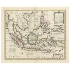
Extremely Rare Map of the East-Indies towards the South-East 'Indonesia', 1725
About the Item
Antique map titled 'La partie des Indes Orientales vers le Zud-Est, depuis Timor jusqu'a Midanao (...).' (The part of the East-Indies towards the South-East, from Timor to Mindanao.) Extremely rare in this edition.
This plate originates from the very scarse: 'La galerie agreable du monde (...). Tome premier des Indes Orientales.', published by P. van der Aa, Leyden, c. 1725. This famous work was published in 66 parts and is the biggest print / map book ever published. Van der Aa incorporated plates by other publishers such as Blaeu, Visscher, de Wit, meurs, Halma, Mortier, Allard in this work and often added broad decorative borders. Probably the costliest and complete universal geographic work ever produced. It is said that only 100 copies were printed. Ref: Koeman Aa9; Phillips 2780 note.
Artists and engravers: Pieter van der Aa (Leiden 1659-1733) was a Dutch publisher best known for preparing maps and atlases. The Galerie Agreable contains plates and maps by the best Dutch engravers: Luiken, Goeree, Mulder, Stoopendaal, ao.
- Dimensions:Height: 14.97 in (38 cm)Width: 19.3 in (49 cm)Depth: 0 in (0.02 mm)
- Materials and Techniques:
- Period:1720-1729
- Date of Manufacture:1725
- Condition:Condition: Good. General age related toning and occasional light staining from handling. Paper edge uncut and thus irregular. Please study image carefully.
- Seller Location:Langweer, NL
- Reference Number:
About the Seller
5.0
Platinum Seller
These expertly vetted sellers are 1stDibs' most experienced sellers and are rated highest by our customers.
Established in 2009
1stDibs seller since 2017
1,965 sales on 1stDibs
Typical response time: <1 hour
- ShippingRetrieving quote...Ships From: Langweer, Netherlands
- Return PolicyA return for this item may be initiated within 14 days of delivery.
More From This SellerView All
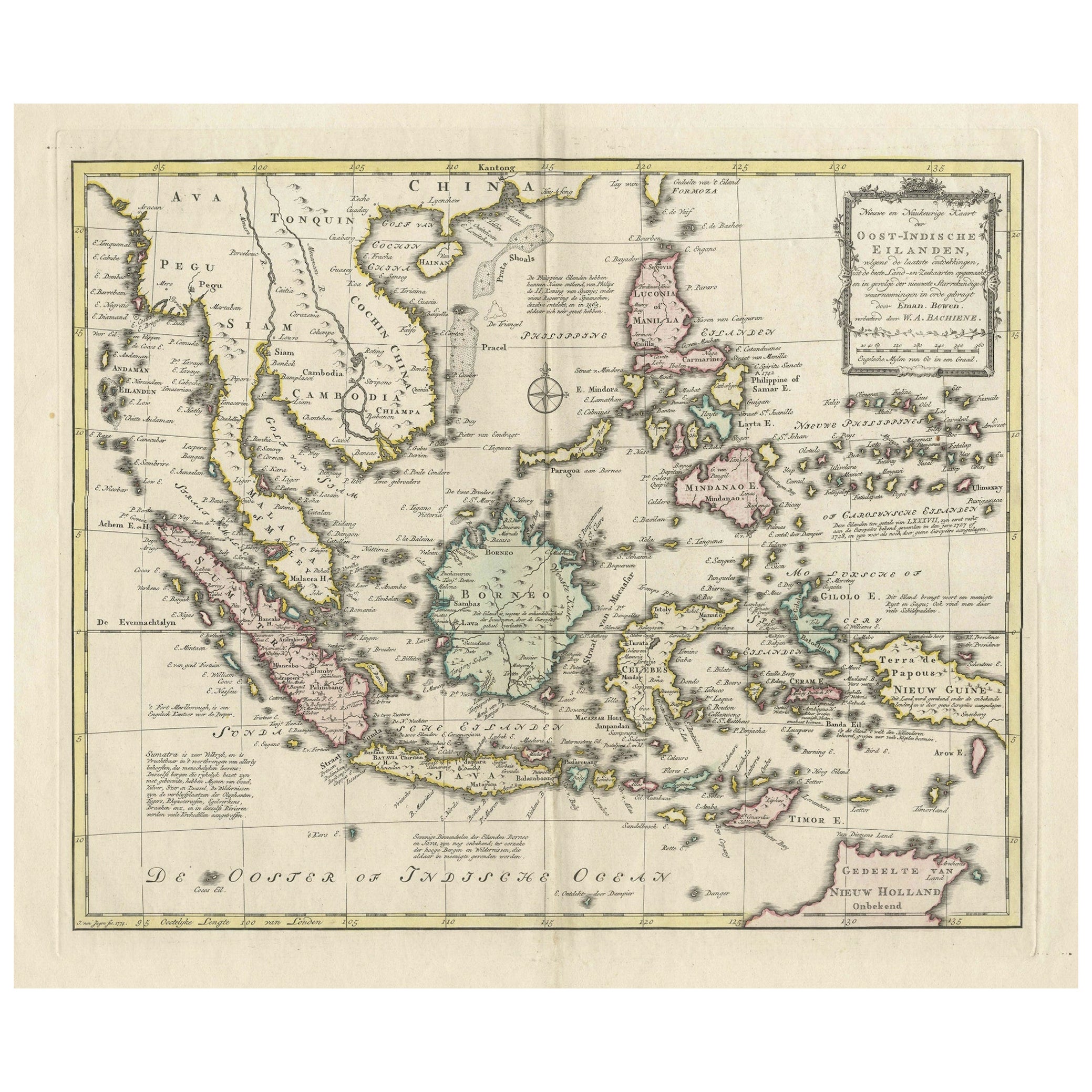
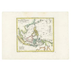
- Rare Antique Map of the Dutch East Indies 'Indonesia', 1774Located in Langweer, NLRare decorative engraved map of the Dutch East Indies, or nowadays Indonesia. Title (in old Dutch): NIEUWE EN NAUKEURIGE KAART DER OOST-INDISCHE ...Category
Antique 1770s Maps
MaterialsPaper
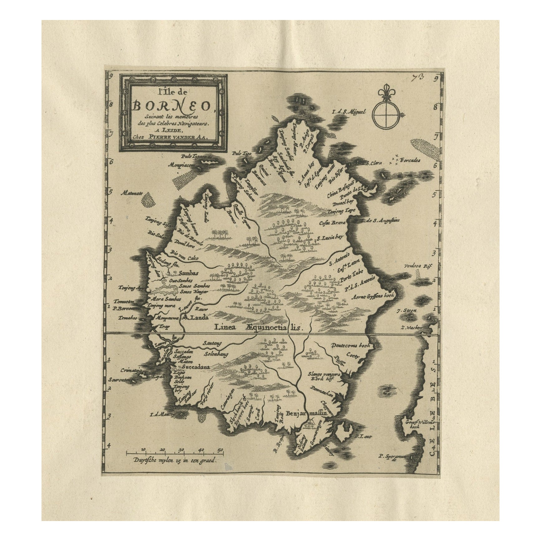
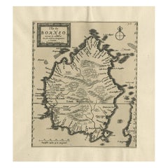
- Extremely Scarce Antique Map of The Island of Borneo, Indonesia, c. 1725Located in Langweer, NLAntique map titled 'L'Ile de Borneo Suivant les memoires des plus Celebres Navigateurs.' A detailed map of the island Borneo, with a small part of Celebes visible. This plate origi...Category
Antique 18th Century Maps
MaterialsPaper
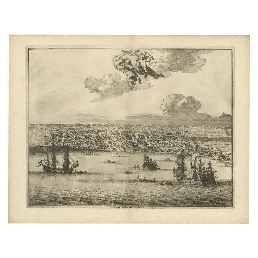
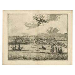
- Print of Makassar 'Ujung Pandang' in the Dutch East Indies 'Indonesia', c.1725By Pieter Van Der AaLocated in Langweer, NLAntique print titled 'Macasar, Capitale du Roiaume de même nom'. This rare print shows Makassar, the present capital of South Sulawesi, Indonesia. In the foreground several VOC ships...Category
Antique 18th Century Prints
MaterialsPaper
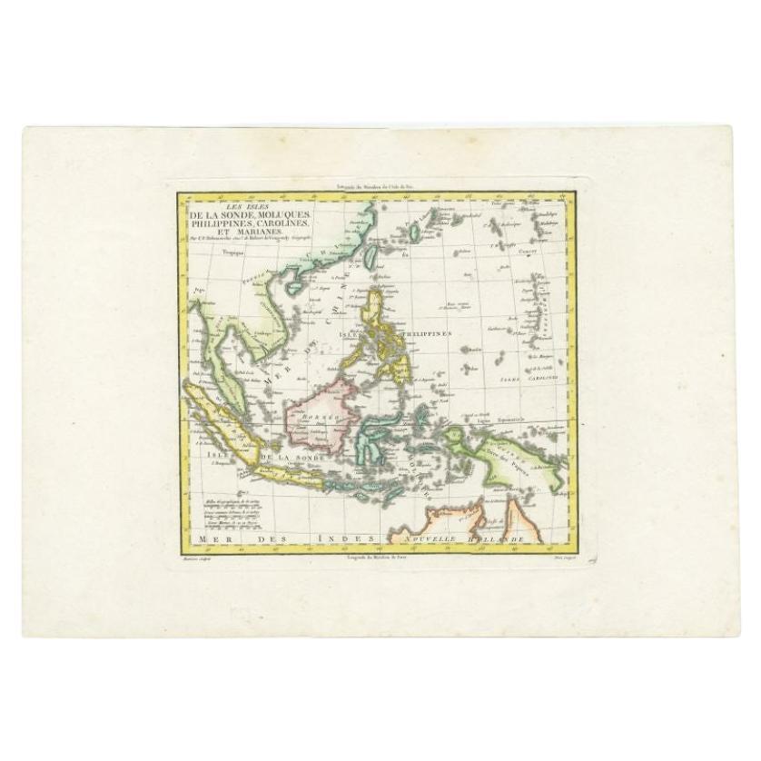
- Antique Colourful Map of the Dutch East Indies 'Indonesia', ca.1806Located in Langweer, NLAntique map titled 'Les Isles de la Sonde Moluques Philippines, Carolines et Marianes'. Old map of the East Indies, also showing a part of Australia. Artists and Engravers: Publi...Category
Antique 19th Century Maps
MaterialsPaper
- Original Antique Map of the East Indies (Indonesia) by Janssonius, c.1644By Johannes JanssoniusLocated in Langweer, NLAntique map titled 'India quae Orientalis dicitur, et Insulae adiacentes'. Old map of the East Indies and Southeast Asia showing the area between India in the West and parts of Japan...Category
Antique 17th Century Maps
MaterialsPaper
- Original Old Map of the Environs of Batavia in the Dutch East Indies (Indonesia)Located in Langweer, NLAntique map titled 'Carte des Environs de Batavia'. Map of the environs of Batavia (now Jakarta), Indonesia. This print originates from volume 8 of 'Histoire générale des voyages'. P...Category
Antique Mid-18th Century Maps
MaterialsPaper


You May Also Like
- Original Antique Map of South East Asia, Arrowsmith, 1820Located in St Annes, LancashireGreat map of South East Asia Drawn under the direction of Arrowsmith Copper-plate engraving Published by Longman, Hurst, Rees, Orme and Brown, 1820 Unframed.Category
Antique 1820s English Maps
MaterialsPaper
- Original Antique Map of South East Asia by Becker, circa 1840Located in St Annes, LancashireGreat map of South East Asia Steel engraving with original color outline Engraved by Becker Published by Virtue, circa 1840. Unframed.Category
Antique 1840s English Other Maps
MaterialsPaper
- Original Antique Map of South East Asia by Thomas Clerk, 1817Located in St Annes, LancashireGreat map of South East Asia Copper-plate engraving Drawn and engraved by Thomas Clerk, Edinburgh. Published by Mackenzie And Dent, 1817 Unframed.Category
Antique 1810s English Maps
MaterialsPaper
- Extremely Rare Copy of the Venezuelan Declaration of Independance, 1811Located in Amsterdam, NLExtremely rare copy of the Venezuelan Declaration of Independance 'Declaracion de Independencia de las Siete Provincias Unidas de Venezuela en Congreso de 5 de Julio de 1811' By Lorenzo Lüthy (c. 1811-1877), printed in Philadelphia, Peter S. Duval, 1841. Lithograph on laid paper, mounted in passepartout, H. 84 x W. 64.5 cm (with mount H. 96,5 x W. 77 cm.) Large and extremely rare lithographed broadside Declaration of Independence of Venezuela by American immigrant...Category
Antique Early 19th Century Venezuelan Prints
MaterialsPaper
- Original Antique Map of South America. C.1780Located in St Annes, LancashireGreat map of South America Copper-plate engraving Published C.1780 Two small worm holes to left side of map Unframed.Category
Antique Early 1800s English Georgian Maps
MaterialsPaper
- Original Antique Map of South America, circa 1830Located in St Annes, LancashireGreat map of South America Copper plate engraving Published by Butterworth, Livesey & Co., circa 1830 Unframed.Category
Antique Early 1800s English Other Maps
MaterialsPaper


Recently Viewed
View AllMore Ways To Browse
Antique Furniture South East
East Indies Furniture
East Indies
Dutch Indies
Map Monde Antique
Atlas Du Monde Antique
Tree Bag
Antique Texas Collectables
Pirate Furniture
Antique Globes 18th Century
James Cook Map
Latitude Longitude
Map Sweden
Canada Map
Caribbean Antiques
English Wheel Used
Ocean Antiques
Antique Turkish Map