Items Similar to Large 1856 Mexico & Guatemala Framed Map by Charles Desilver

Want more images or videos?
Request additional images or videos from the seller
1 of 11
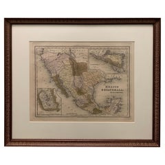
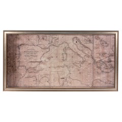
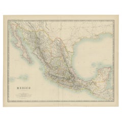
Large 1856 Mexico & Guatemala Framed Map by Charles Desilver
About the Item
Large 1856 Mexico & Guatemala Framed map. Published by Charles Desilver, Philadelphia, Pennsylvania.
As found high end custom framing with black giltwood frame, custom matting and UV resistant glass.
- Dimensions:Height: 20 in (50.8 cm)Width: 23 in (58.42 cm)Depth: 1.5 in (3.81 cm)
- Style:American Classical (In the Style Of)
- Materials and Techniques:
- Place of Origin:
- Period:
- Date of Manufacture:1856
- Condition:Additions or alterations made to the original: Framed. Wear consistent with age and use. As found framed condition. Has not been examined outside of the frame.
- Seller Location:Stamford, CT
- Reference Number:1stDibs: LU1860320213362
About the Seller
5.0
Platinum Seller
These expertly vetted sellers are 1stDibs' most experienced sellers and are rated highest by our customers.
Established in 2010
1stDibs seller since 2016
397 sales on 1stDibs
Typical response time: 1 hour
- ShippingRetrieving quote...Ships From: Stamford, CT
- Return PolicyA return for this item may be initiated within 2 days of delivery.
More From This SellerView All
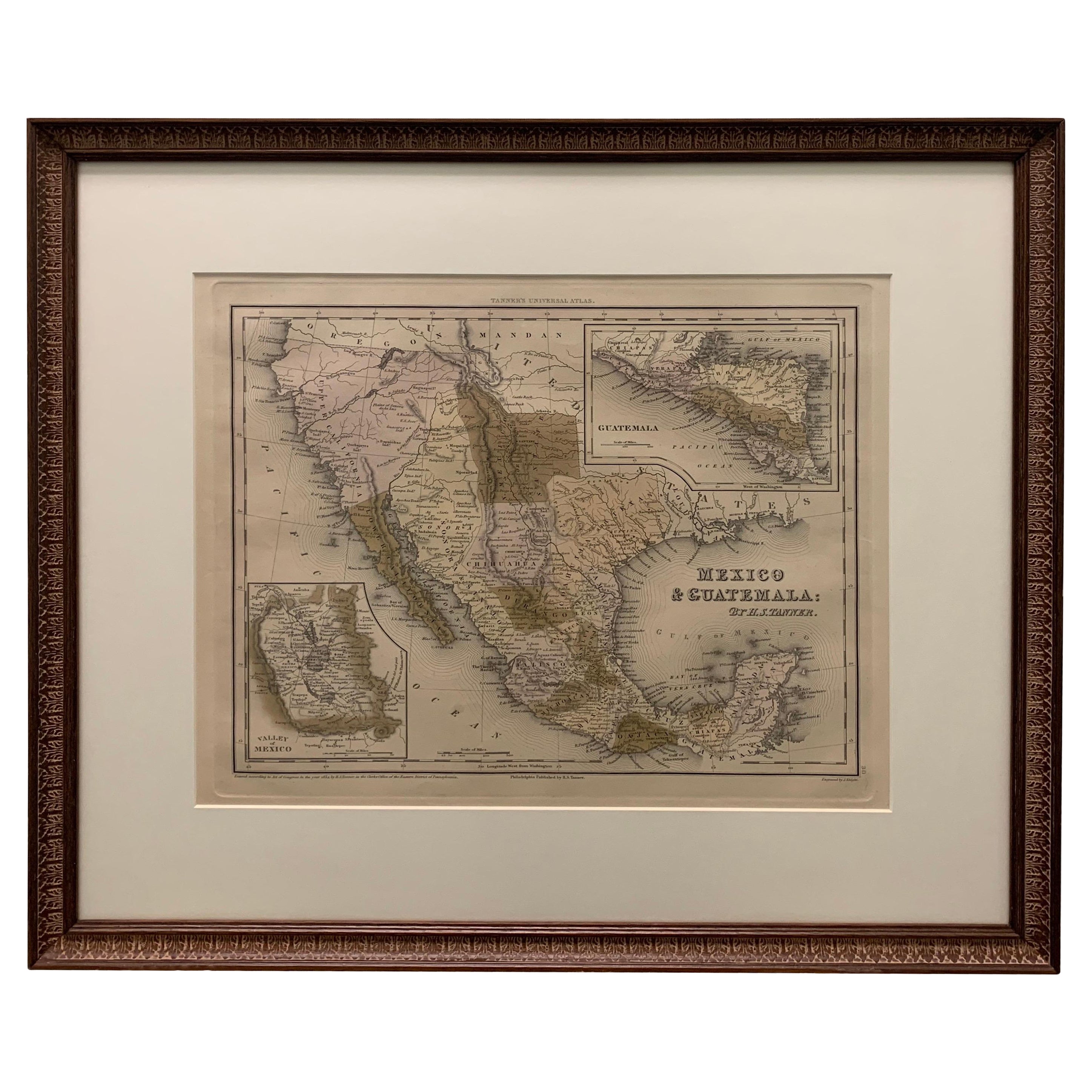
- 1834 Mexico & Guatemala Framed Map by H.S. TannerLocated in Stamford, CT1834 Mexico & Guatemala map of published by H.S. Tanner, Philadelphia, Pennsylvania. Engraved by J. Knight. As found high end custom framing with carved wood frame, custom matting a...Category
Antique 1830s American American Classical Maps
MaterialsGlass, Wood, Paper
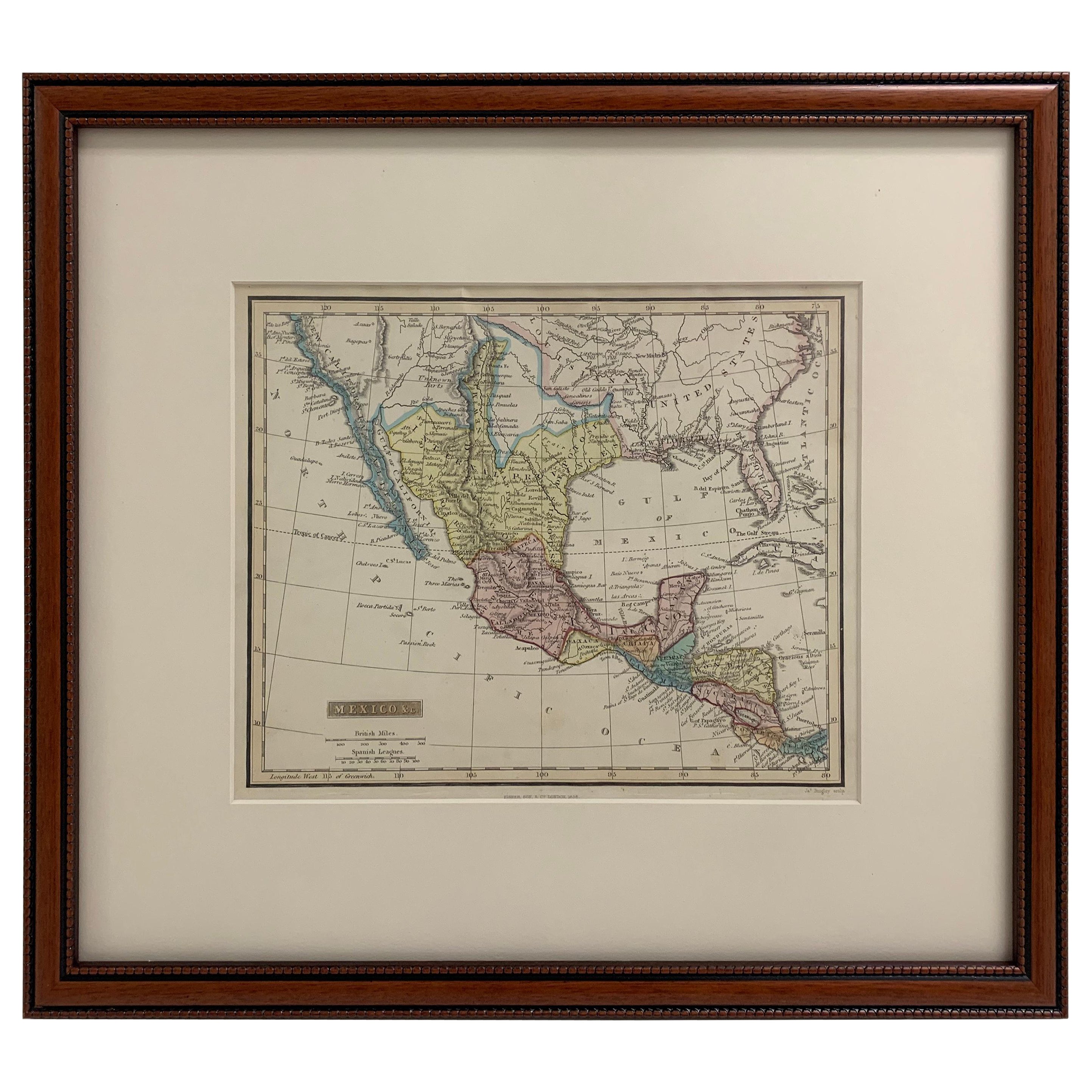
- Framed 1838 Mexico & Gulf of Mexico MapLocated in Stamford, CTFramed 1838 Mexico & Gulf of Mexico map. Printed by Fisher, Son & Co. of London in 1838. As found framed condition. Map has not been examined outside of th...Category
Antique 1830s English American Classical Maps
MaterialsGlass, Wood, Paper
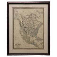
- 1830 Mexico and United States Framed MapLocated in Stamford, CTMap of North America published circa 1830. Map shows United States into Canada. Mexico extending into the upper California territory. Texas appears in name but prior to the period of...Category
Antique 1830s American American Classical Maps
MaterialsGlass, Wood, Paper
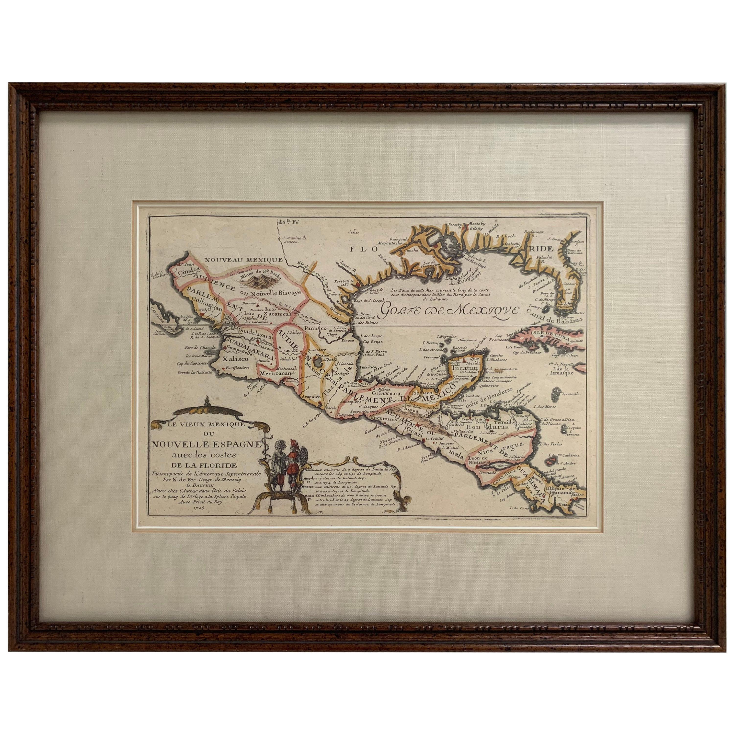
- 1705 Golfe de Mexico and Florida Framed MapLocated in Stamford, CTFramed map of Mexico & Florida circa 1705, Paris. Small map with Mexico and the Gulf Coast. Inset text indicating Panama, Acapulco, Mexico City and the Mississippi. Extends North to ...Category
Antique Early 1700s French Spanish Colonial Maps
MaterialsGlass, Wood, Paper
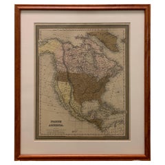
- Framed 1838 North America & Recent Discoveries MapLocated in Stamford, CT1838 map of North America & recent discoveries. Engraved color map by J. Wyld, London, England. This map shows Texas as a Republic without its panhandle. Framed in brown carved wood...Category
Antique 1830s American American Classical Maps
MaterialsGlass, Wood, Paper
- Large 1848 North America & Territories MapLocated in Stamford, CTFramed 1848 S. Augustus and Mitchell, Philadelphia , PA North America and territories map. Featuring the United States, Canada (British Territory) and Mexican Territories. As found...Category
Antique 1840s American American Classical Maps
MaterialsGlass, Wood, Paper


You May Also Like
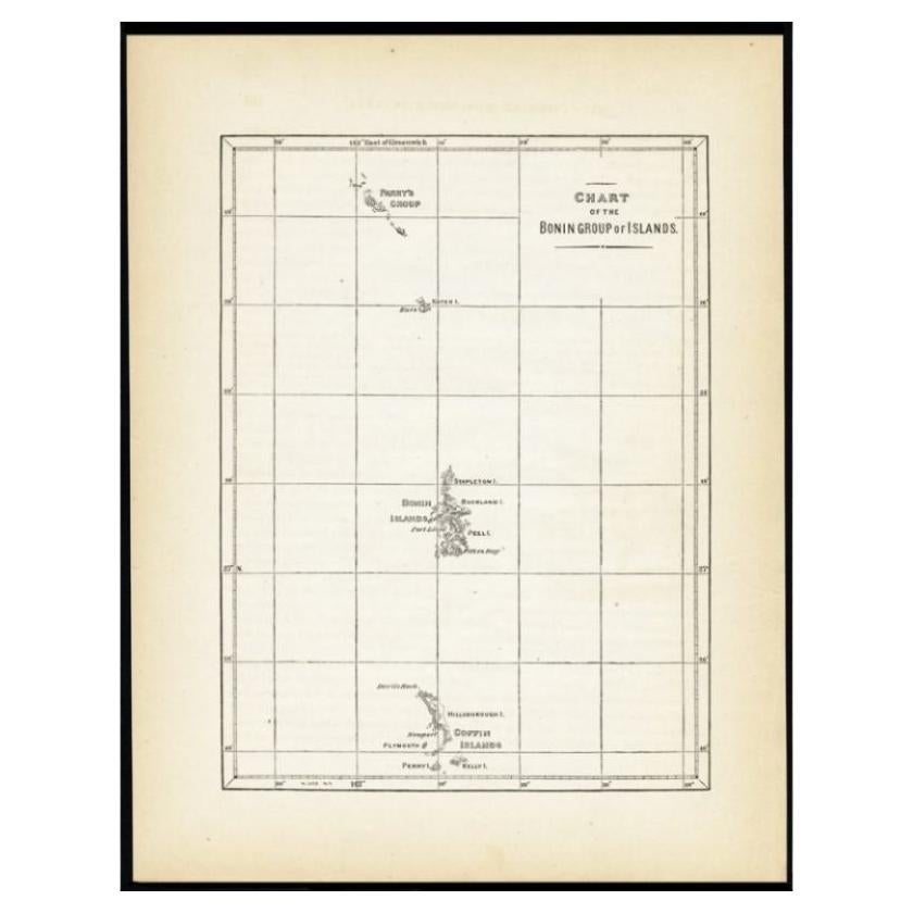
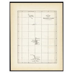
- Antique Map of the Bonin Islands by Hawks, 1856Located in Langweer, NLAntique map titled 'Chart of the Bonin Group of Islands.' The Bonin Islands, known in Japan as the Ogasawara Group are an archipelago of over 30 subtropical and tropical islands, som...Category
Antique 19th Century Maps
MaterialsPaper
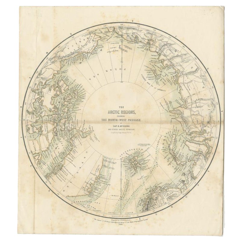
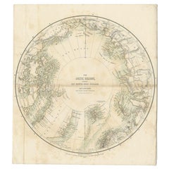
- Antique Map of the North Pole by Fullarton, 1856Located in Langweer, NLAntique map titled 'The Arctic Regions showing the North-West Passage of Captain R. McClure'. Old map of the North Pole, displaying the Northwest Passage di...Category
Antique 19th Century Maps
MaterialsPaper
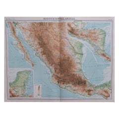
- Large Original Vintage Map of Mexico, circa 1920Located in St Annes, LancashireGreat maps of Mexico. Unframed. Original color. By John Bartholomew and Co. Edinburgh Geographical Institute. Published, circa 1920. Free shipping.Category
Vintage 1920s British Maps
MaterialsPaper
- Large Framed Map of the MediterraneanLocated in New York, NYLarge map/chart chart of The Mediterranean and the Grecian Archipelago showing Italy, Sardinia, Corsica, part of France, etc. in a black frame.Category
20th Century French Mid-Century Modern Maps
- Antique Map of Mexico by Johnston, '1909'Located in Langweer, NLAntique map titled 'Mexico'. Original antique map of Mexico. This map originates from the ‘Royal Atlas of Modern Geography’. Published by W. & A....Category
Early 20th Century Maps
MaterialsPaper
- Antique Map of Mexico by W. G. Blackie, 1859Located in Langweer, NLAntique map titled 'Mexico'. Original antique map of Mexico. This map originates from ‘The Imperial Atlas of Modern Geography’. Published by W. G. Blackie, 1859.Category
Antique Mid-19th Century Maps
MaterialsPaper
Recently Viewed
View AllMore Ways To Browse
Custom Antique Frames
United States Map
Framed Map
Antique Map Framing
Antique Maps Framed
Framing Antique Maps
Antique Map United States
Antique United States Maps
Guatemala Wood
Used Furniture Philadelphia Pennsylvania
Framed Map United States
Antique Map Mexico
Antique Maps Mexico
Large Framed Antique Maps
Large Framed Maps
Philadelphia Classical
Mexican Giltwood
Antique Guatemalan Furniture