Items Similar to Nice Decorative Hand-Colored Antique Map of Italy, ca.1745
Want more images or videos?
Request additional images or videos from the seller
1 of 5
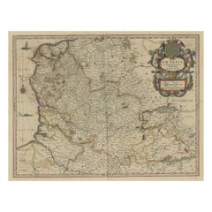
Nice Decorative Hand-Colored Antique Map of Italy, ca.1745
About the Item
Antique map Italy titled 'A New Map of Italy from the lastest observations'.
Antique map of Italy originating from 'Geography Anatomiz'd: or, The Geographical Grammar'.
Artists and Engravers: Published by P. Gordon, London.
- Dimensions:Height: 7.68 in (19.5 cm)Width: 9.06 in (23 cm)Depth: 0 in (0.02 mm)
- Materials and Techniques:
- Period:1740-1749
- Date of Manufacture:circa 1745
- Condition:Condition: Very good, please study image carefully.
- Seller Location:Langweer, NL
- Reference Number:
About the Seller
5.0
Platinum Seller
These expertly vetted sellers are 1stDibs' most experienced sellers and are rated highest by our customers.
Established in 2009
1stDibs seller since 2017
1,965 sales on 1stDibs
Typical response time: <1 hour
- ShippingRetrieving quote...Ships From: Langweer, Netherlands
- Return PolicyA return for this item may be initiated within 14 days of delivery.
More From This SellerView All
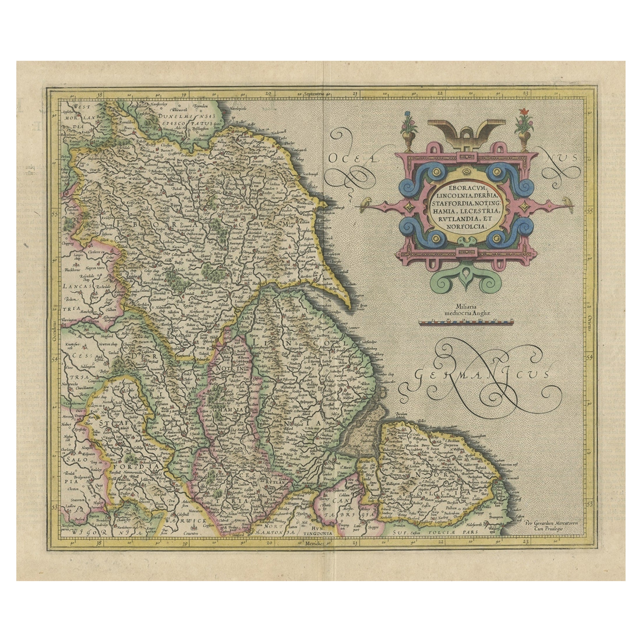
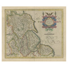
- Decorative Early Hand-Colored Map of the Northeast of England, ca.1620Located in Langweer, NLAntique map titled 'Eboracum, Lincolnia, Derbia, Staffordia, Notinghamia, Lecestria, Rutlandia et Norfolcia'. Decorative early map of the northeast of England, comprising the cou...Category
Antique 1620s Maps
MaterialsPaper
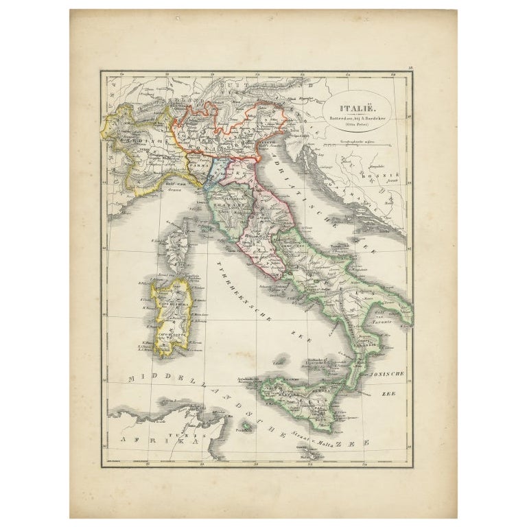
- Antique Map of Italy with Hand-Colored Borders, 1852Located in Langweer, NLAntique map titled 'Italië'. Map of Italy. This map originates from 'School-Atlas van alle deelen der Aarde' by Otto Petri. Artists and Engravers: Published by A. Baedeker (Otto Petr...Category
Antique 19th Century Maps
MaterialsPaper
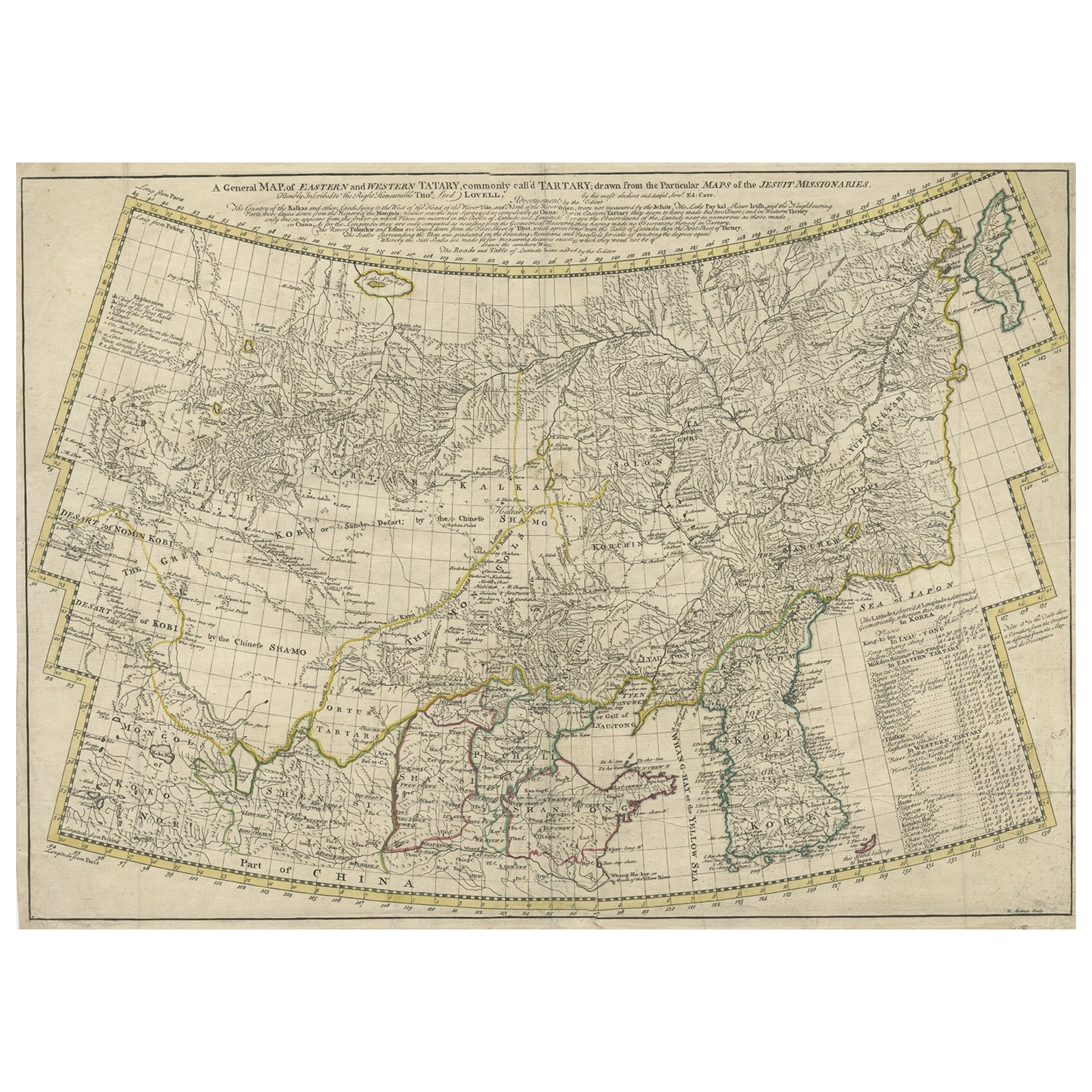
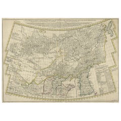
- Rare Hand-Colored Antique Map of Tartary, China and Korea, ca.1741Located in Langweer, NLAntique map titled 'A General Map of Eastern and Western Tatary, commonly call'd Tartary; drawn from the Particular Maps of the Jesuit Missionaries'. Rare antique map of Tartary, C...Category
Antique 1740s Maps
MaterialsPaper
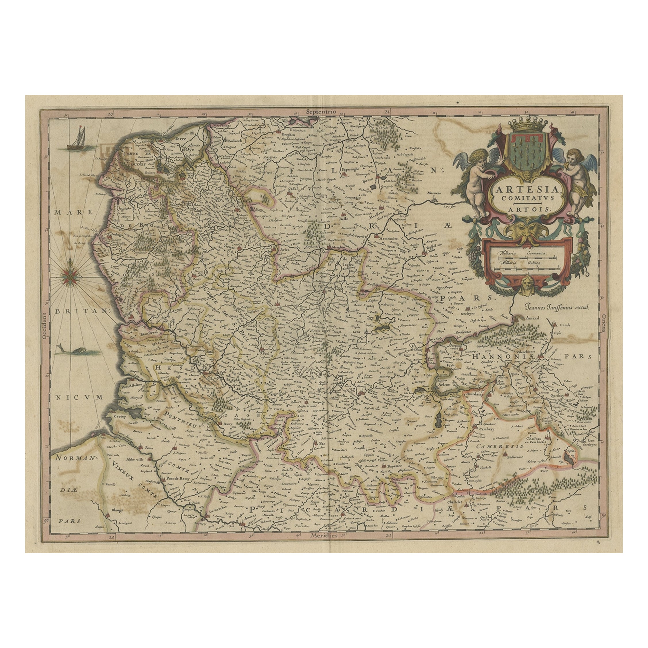
- Original Hand-Colored Antique Map of Artois or Artesia, France, ca.1650Located in Langweer, NLAntique map titled 'Artesia Comitatus Artois'. Map of Artois or Artesia, France. Artois is former province located in the northwestern part of France, boarding Belgium (Flanders)...Category
Antique 1650s Maps
MaterialsPaper
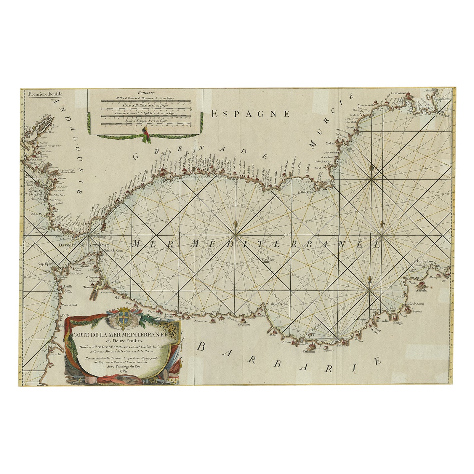
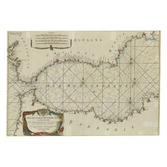
- Large Decorative Antique Map of the Mediterranean, ca.1770Located in Langweer, NLAntique map titled 'Carte de la Mer Mediterranee en Douze Feuilles'. First map out of twelve fine engraved double-page and folding maps that join to create a large wall map...Category
Antique 1770s Maps
MaterialsPaper
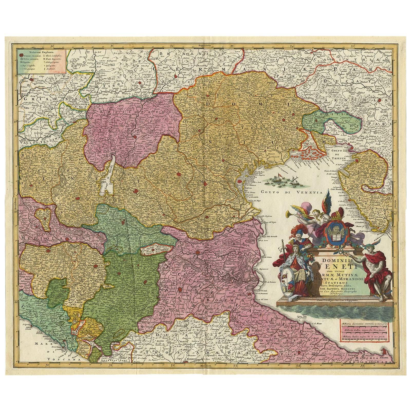
- Stunning Antique Map of Northern Italy by J.B. Homann, circa 1745By Johann Baptist HomannLocated in Langweer, NLThis beautiful hand-colored map covers from Bergamo east as far as Albona (Labin) and from Vipiteno Sterzing south as far as Florence. The map is exceptionally detailed, noting towns, rivers, lakes, cities and a host of additional topographical features. Includes neighboring Parma, Modena, Mantua and Mirandol. The map depicts the Veneto region and its vicinity during the decline of the Republic of Venice. A key in included in the top left quadrant of the map, while a beautifully engraved title cartouche adorns the lower right quadrant. This map was issued in Homann Heirs circa 1745 edition of Atlas Novus Terrarum Orbis.Category
Antique Mid-18th Century Maps
MaterialsPaper


You May Also Like
- Hand-Colored 18th Century Homann Map of the Danube, Italy, Greece, CroatiaBy Johann Baptist HomannLocated in Alamo, CA"Fluviorum in Europa principis Danubii" is a hand colored map of the region about the Danube river created by Johann Baptist Homann (1663-1724) in his 'Atlas Novus Terrarum', publish...Category
Antique Early 18th Century German Maps
MaterialsPaper
- The Kingdom of Naples and Southern Italy: A Hand-Colored 18th Century Homann MapBy Johann Baptist HomannLocated in Alamo, CA"Novissima & exactissimus Totius Regni Neapolis Tabula Presentis Belli Satui Accommo Data" is a hand colored map of southern Italy and the ancient Kingdom of Naples created by Johann...Category
Antique Early 18th Century German Maps
MaterialsPaper
- England, Scotland & Ireland: A Hand Colored Map of Great Britain by TirionBy Isaak TirionLocated in Alamo, CAThis is a hand-colored double page copperplate map of Great Britain entitled "Nieuwe Kaart van de Eilanden van Groot Brittannien Behelzende de Kon...Category
Antique Mid-18th Century Dutch Maps
MaterialsPaper
- 17th Century Hand-Colored Map of West Africa by Mercator/HondiusLocated in Alamo, CAA 17th century hand-colored map entitled "Guineae Nova Descriptio" by Gerard Mercator and Jodocus Hondius, published in their 'Atlas Minor' in Amsterdam in 1635. It is focused on the...Category
Antique Mid-17th Century Dutch Maps
MaterialsPaper
- Original Antique Map of Italy. Arrowsmith. 1820Located in St Annes, LancashireGreat map of Italy Drawn under the direction of Arrowsmith Copper-plate engraving Published by Longman, Hurst, Rees, Orme and Brown, 1820 Unframed.Category
Antique 1820s English Maps
MaterialsPaper
- "Nova Barbariae Descriptio", a 17th Century Hand-Colored Map of North AfricaBy Johannes JanssoniusLocated in Alamo, CAThis original attractive 17th century hand-colored map of North Africa entitled "Nova Barbariae Descriptio" by Johannes Janssonius was published in Paris in 1635. It includes the Med...Category
Antique Mid-17th Century Dutch Maps
MaterialsPaper


Recently Viewed
View AllMore Ways To Browse
Gordon Antique Furniture
Antique Map Of New England
Antique Maps New England
Ireland Map
Map Of Ireland
Caribbean Antique Furniture
Old Italian Map
18th Century Maps America
Map Of Portugal
Antique Caribbean Furniture
Portugal Map
18th Century Compass
Antique Map New York
Antique Maps New York
Rare Compass
Map Of Brazil
Antique Map Of New York
Antique Marine Maps