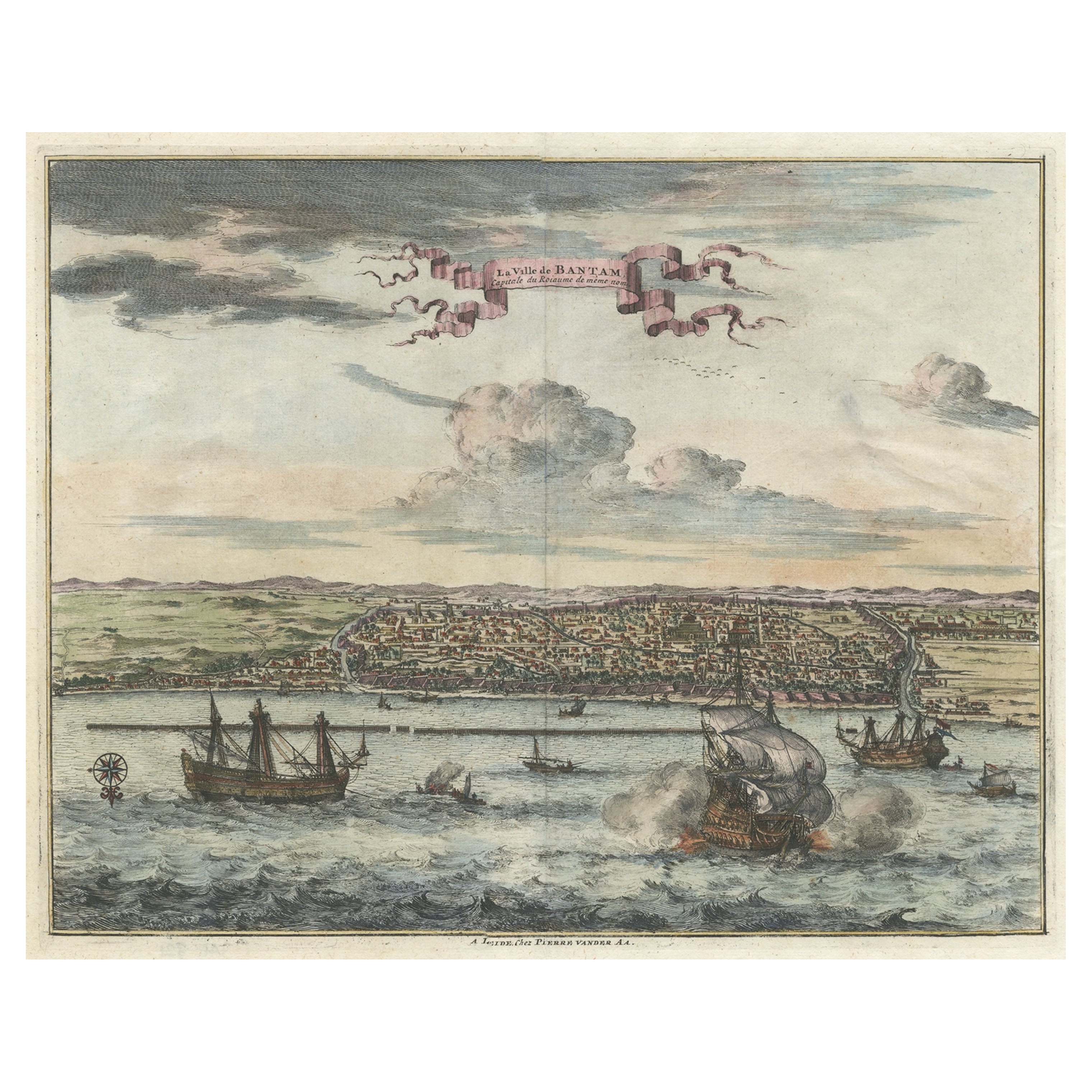
Items Similar to View of the City Banten or Bantam Near the Western End of Java, Indonesia, c1725

Want more images or videos?
Request additional images or videos from the seller
1 of 5
View of the City Banten or Bantam Near the Western End of Java, Indonesia, c1725
About the Item
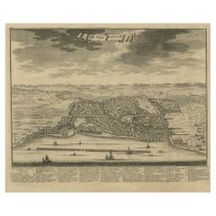
Antique print titled 'La Ville de Bantam capitale du Roiaume de meme nom'.
A bird's eye view of the city Banten or Bantam near the western end of Java in Indonesia. Several tall ships and smaller nautical vessels in the harbour. This print originates from the very scarse: La Galerie Agréable du Monde ( ). , published by P. van der Aa, in Leiden, c. 1725.
Artists and engravers: Pieter van der Aa Pieter van der Aa (Leiden 1659-1733) was a Dutch publisher best known for preparing maps and atlases. The Galerie Agreable contains plates and maps by the best Dutch engravers: Luiken, Goeree, Mulder, Stoopendaal, Aldert Meijer, Romeyn de Hooghe, ao.
- Dimensions:Height: 12.01 in (30.5 cm)Width: 16.15 in (41 cm)Depth: 0 in (0.02 mm)
- Materials and Techniques:
- Period:1720-1729
- Date of Manufacture:circa 1725
- Condition:Wear consistent with age and use. Condition: Good, given age. Margins cropped to the platemark. Attached to carrier sheet. Margins of the carrier faintly discoloured and the top edge warped. General age-related toning and/or occasional minor defects from handling.
- Seller Location:Langweer, NL
- Reference Number:
About the Seller
5.0
Platinum Seller
These expertly vetted sellers are 1stDibs' most experienced sellers and are rated highest by our customers.
Established in 2009
1stDibs seller since 2017
1,965 sales on 1stDibs
Typical response time: <1 hour
- ShippingRetrieving quote...Ships From: Langweer, Netherlands
- Return PolicyA return for this item may be initiated within 14 days of delivery.
More From This SellerView All
- Original Antique Bird's Eye View of Banten or Bantam in Java, Indonesia, 1725Located in Langweer, NLAntique print titled 'La Ville de Bantam capitale du Roiaume de meme nom'. A bird's eye view of the city Banten or Bantam near the western end of Java in Indonesia. Several tall ...Category
Antique 1720s Prints
MaterialsPaper
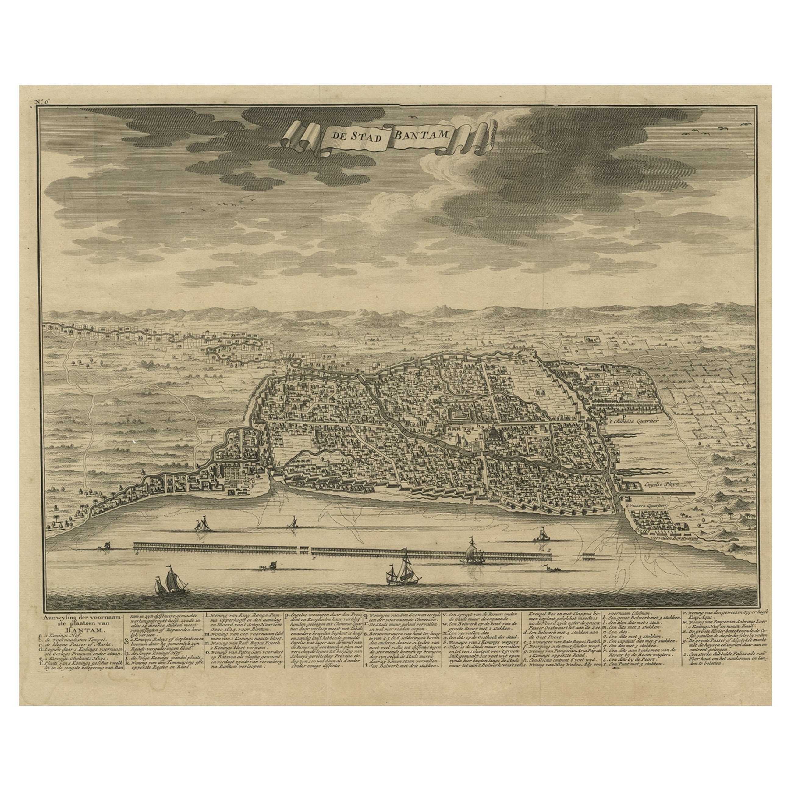
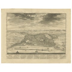
- Decorative View of the Indonesian Town of Bantam 'Banten', Java, 1726Located in Langweer, NLDecorative town-view of the town of Bantam (Banten). In lower margin key a-z to the principal places in town. The Banten Sultanate was founded in the 16th century and centred in ...Category
Antique 1720s Maps
MaterialsPaper
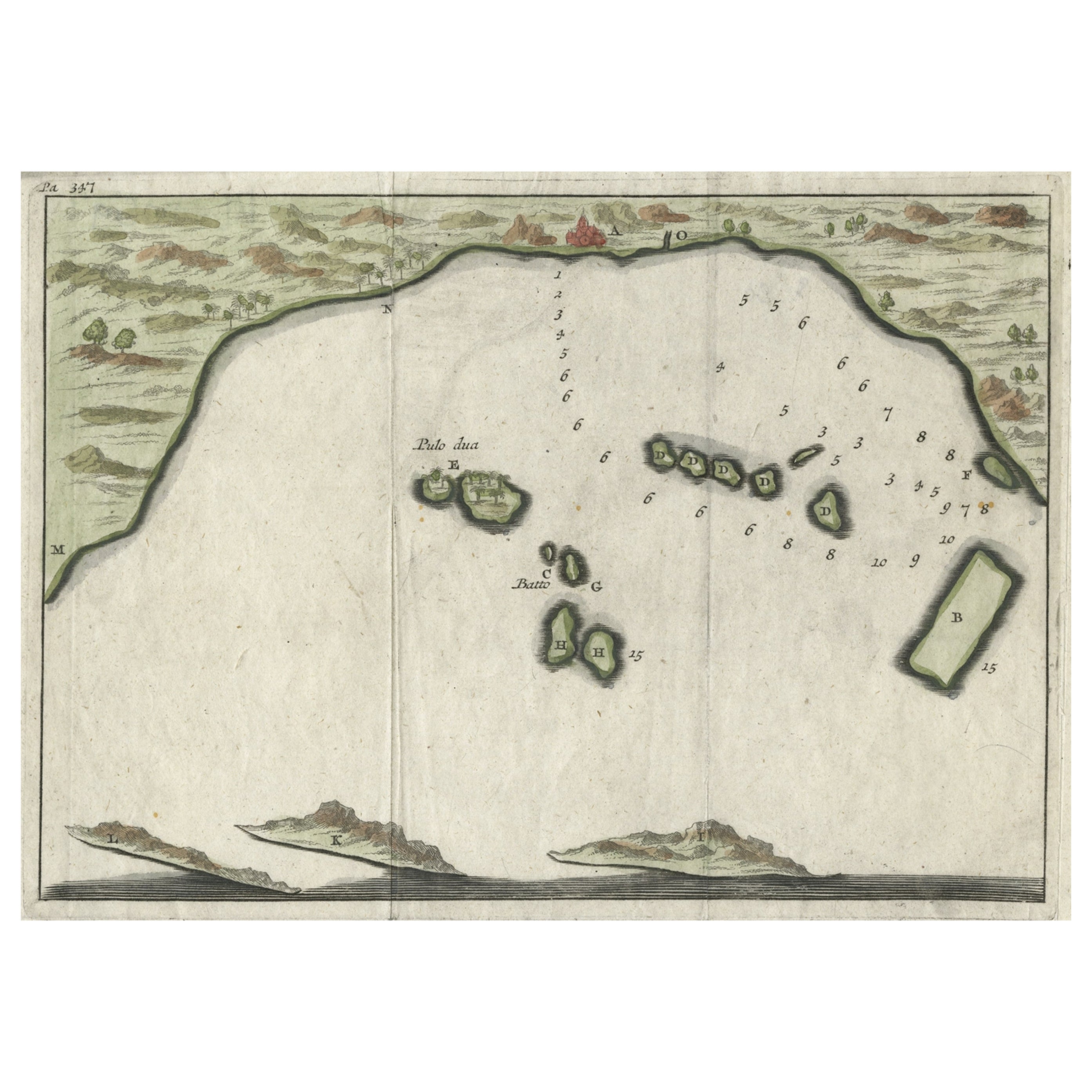
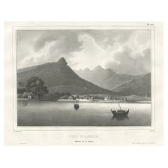
- Antique Map of Banten Bay, Java, Indonesia, c.1725Located in Langweer, NLA small early 18th century map of Banten Bay showing the islands of Pulo Dua and Pulo Batto together with soundings within the Bay and profiles of hills on the islands published by C...Category
Antique 18th Century Maps
MaterialsPaper
- Antique Print of Bantam or Banten, Java, Indonesia, '1726'Located in Langweer, NLAntique print titled 'De Stad Bantam'. Decorative town-view of the town of Bantam (Banten). In lower margin key a-z to the principal places in town. The Banten Sultanate was founded ...Category
Antique Mid-18th Century Prints
MaterialsPaper
- Small Early 18th Century Map of Banten Bay on the Island Java, Indonesia, c.1725Located in Langweer, NLA small early 18th century map of Banten Bay showing the islands of Pulo Dua and Pulo Batto together with soundings within the Bay and profiles of hills on the islands published by C...Category
Antique 1720s Maps
MaterialsPaper
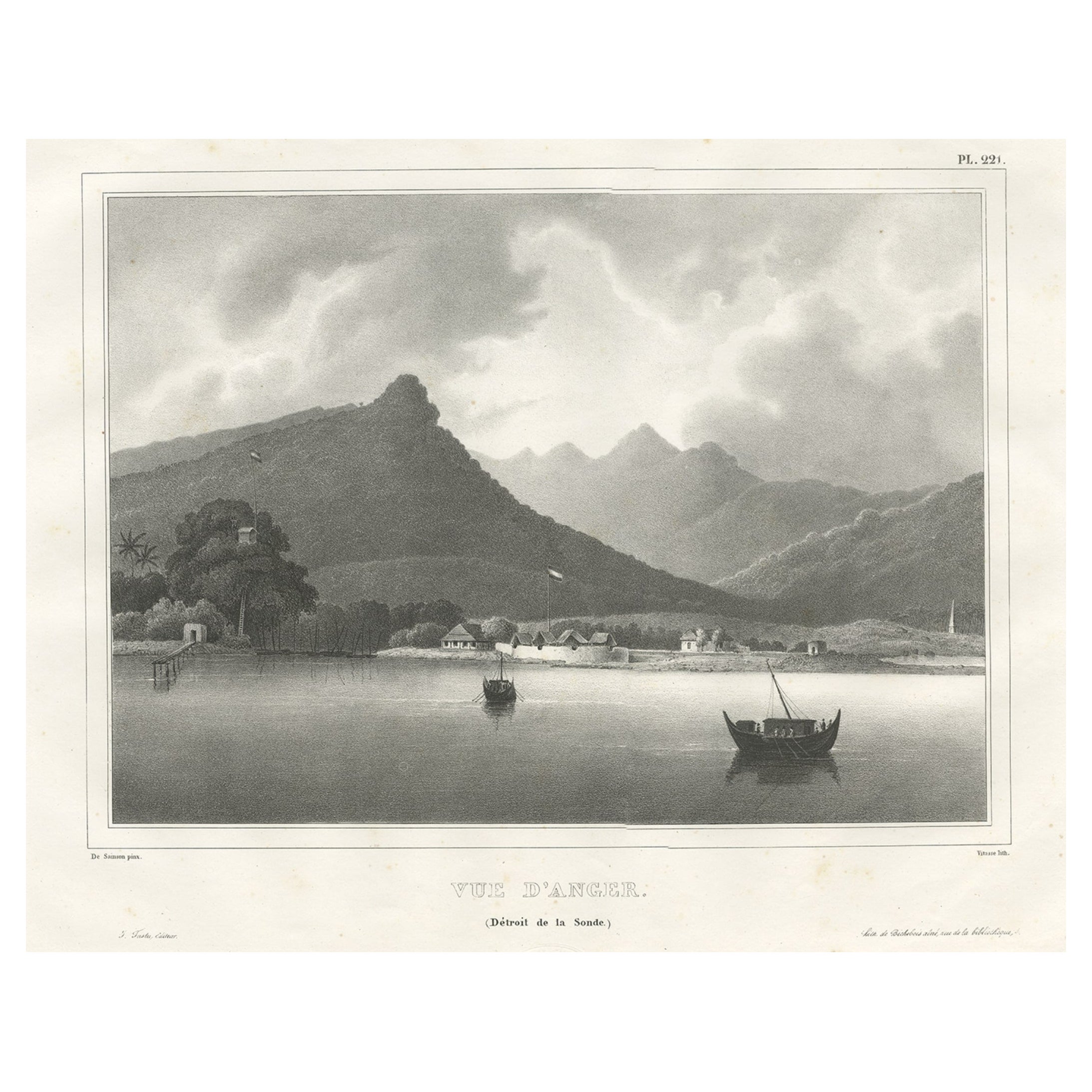
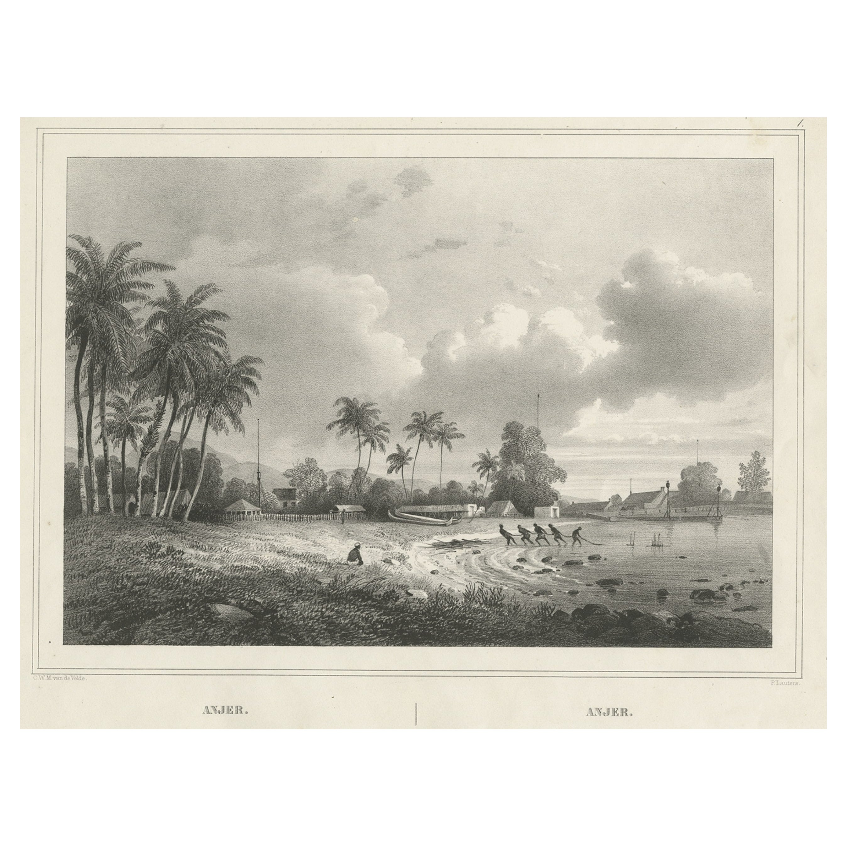
- Old Print of the City of Anyer, West-Java Near Krakatau Volcano, Indonesia, 1833Located in Langweer, NLAntique print titled 'Vue d'Anger (Détroit de la Sonde)'. View of the city of Anyer, a coastal town in Banten, formerly West Java, Indonesia. This print originates from 'Voyage de la Corvette l'Astrolabe exécuté par ordre du Roi pendant les années 1826, 1827, 1828, 1829' by Jules Sebastien Cesar Dumont D'Urville. Artists and Engravers: Published by J. Tastu. Dumont was a French explorer and naval officer. For thirty-eight months he explored the south and western Pacific...Category
Antique 19th Century Prints
MaterialsPaper


You May Also Like
- Catalogue of Engraved Views, Plans, Etc., Of New York City, 1st EdLocated in valatie, NYA catalogue of engraved views, plans, etc., Of New York City, (The Collection of Percy R. Pyne II). Privately Printed by The De Vinne Press, New York, 1912. Limited to 100 copies. Gr...Category
Early 20th Century American Books
MaterialsPaper
- American Western Movie Lithograph "The Treasure of the Sierra Madre", SignedLocated in Miami, FLA very nice Hollywood movie original lithograph for the film The Treasure of the Sierra Madre, directed by John Huston. Starring Humphrey Bogart, Walter H...Category
Early 20th Century American Prints
MaterialsPaper
- Vintage "View of the Center of Paris Taken from the Air" Lithograph MapLocated in San Diego, CAA very stylish "View of the Center of Paris Taken from the Air" lithograph map published by the Paris Ministry of Tourism, circa early 1950s. The piece measures 27" x 43" and shows...Category
20th Century French Mid-Century Modern Prints
MaterialsPaper
- City View of Nuremberg, Germany: An 18th Century Hand-Colored Map by M. SeutterBy Matthew SeutterLocated in Alamo, CAAn 18th century hand-colored city view of Nuremburg, Germany entitled "Geometrischer Grundris der des Heiligen Römischen Reichs Freyen Stadt Nürnberg" by Matthaus Seutter from his "A...Category
Antique Mid-18th Century German Maps
MaterialsPaper
- 18th Century French Map and City View of Joppe/Jaffa 'Tel Aviv' by SansonBy Nicolas SansonLocated in Alamo, CAAn original antique engraving entitled "Joppe; in ’t Hebreeusch by ouds Japho; hedendaags Japha, of Jaffa; volgens d’aftekening gedaan 1668", by Nicholas Sanson d'Abbeville (1600 - 1667). This is a view of the city of Joppe (in Hebrew Japho), now called Japha or Jaffa, the harbor portion of modern day Tel Aviv, Israel as it appeared in 1668 . It depicts a very busy harbor with numerous boats. A large ship on the left appears to be firing its canons and a small ship on the right appears to be sitting very low in the water, either heavily loaded with cargo or sinking. The town is seen on the far shore with a fortress on a hill across in the background. The map is printed from the original Sanson copperplate and was published in 1709 by his descendants. The map is presented in an ornate brown wood frame embellished by gold-colored leaves and gold inner trim with a double mat; the outer mat is cream-colored and the inner mat is black. There is a central vertical fold, as issued. There are two small spots in the lower margin and one in the upper margin, as well as two tiny spots adjacent to the central fold. 1717 is written below the date 1668 in the inscription. The map is otherwise in very good condition. Another map of the "Holy Land" (by Claes Visscher in 1663), with an identical style frame and mat is available. This pair of maps would make a wonderful display grouping. Please see Reference #LU5206220653552. A discount is available for the purchase of the pair of maps. Artist: Nicholas Sanson d'Abbeville (1600-1667) and his descendents were important French cartographer's active through the 17th century. Sanson started his career as a historian and initially utilized cartography to illustrate his historical treatises. His maps came to the attention of Cardinal Richelieu and then King Louis XIII of France, who became a supporter and sponsor. He subsequently appointed Sanson 'Geographe Ordinaire du Roi' the official map maker to the king. Sanson not only created maps for the king, but advised him on geographical issues and curated his map collection...Category
Antique Early 18th Century French Maps
MaterialsPaper
- N.E. View of the United States Capitol, Washington, DC Antique Proof Print 1858Located in Colorado Springs, COThis engraved print shows a view of the United States Capitol Building, in Washington, D.C. The print depicts the neoclassical building from the northeast orientation, with a bustling street scene in front. The steel engraving is a proof printing, drawn and engraved by Henry Sartain and published in 1858. Plans began in May 1854 to build a new cast-iron dome for the United States Capitol. The then-architect of the Capitol Thomas Walter and his team were sold on the aesthetics of a new dome, as well as the utility of a fire-proof one. A year later, on March 3, 1855, President Franklin Pierce...Category
Antique 1850s American Prints
MaterialsPaper


Recently Viewed
View AllMore Ways To Browse
Western Plates
Java Dutch
Indonesia Bird
Map Monde Antique
Nautical Maps
Nautical Antique Plates
Antique Nautical Prints
Birds Eye View Map
Dutch Harbour
Antique Nautical Map
Antique Nautical Maps
Atlas Du Monde Antique
Antique Memes
Java Bird
Tree Bag
Antique Texas Collectables
Pirate Furniture
Antique Globes 18th Century