Items Similar to Antique Hand-Colored Map of France by J.B. Elwe, 1792


Want more images or videos?
Request additional images or videos from the seller
1 of 9
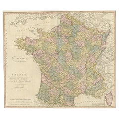
Antique Hand-Colored Map of France by J.B. Elwe, 1792
About the Item
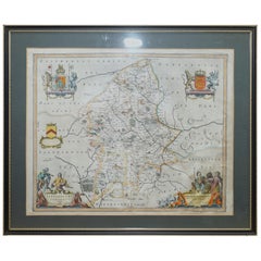
Antique map titled 'Carte Nouvelle du Royaume de France'. Beautiful antique map of France, including the Southern part of England. Decorated with cartouche and 12 coats of arms.
- Dimensions:Height: 21.07 in (53.5 cm)Width: 25.99 in (66 cm)Depth: 0.02 in (0.5 mm)
- Materials and Techniques:Paper,Engraved
- Period:
- Date of Manufacture:1792
- Condition:Please study image carefully.
- Seller Location:Langweer, NL
- Reference Number:Seller: BGI-002191stDibs: LU305439153221
About the Seller
5.0
Platinum Seller
These expertly vetted sellers are 1stDibs' most experienced sellers and are rated highest by our customers.
Established in 2009
1stDibs seller since 2017
1,976 sales on 1stDibs
Typical response time: <1 hour
- ShippingRetrieving quote...Ships From: Langweer, Netherlands
- Return PolicyA return for this item may be initiated within 14 days of delivery.
Auctions on 1stDibs
Our timed auctions are an opportunity to bid on extraordinary design. We do not charge a Buyer's Premium and shipping is facilitated by 1stDibs and/or the seller. Plus, all auction purchases are covered by our comprehensive Buyer Protection. Learn More
More From This SellerView All
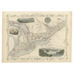
- Beautiful Decorative Hand-Colored Antique Map of West Canada, 1851Located in Langweer, NLDescription: Antique map of Canada titled 'West Canada'. With decorative vignettes titled Kingston and Falls of Niagara. Originates from 'The Illustrated Atlas, And Modern History Of The World Geographical, Political, Commercial & Statistical, Edited By R. Montgomery Martin'. Published; John Tallis London, New York, Edinburgh & Dublin. 1851. Drawn and Engraved by J. Rapkin. Artists and Engravers: John Tallis (1817-1876) was a British map...Category
Antique 1850s Maps
MaterialsPaper
- Antique Map of France by Faden '1792'Located in Langweer, NLAntique map titled 'France divided into Metropolitan Circles (..)'. Large, original antique map of France, with a small inset of the island of Co...Category
Antique Late 18th Century Maps
MaterialsPaper
- Antique Map of France by Faden, 1792Located in Langweer, NLAntique map titled 'France divided into Metropolitan Circles (..)'. Large, original antique map of France, with a small inset of the island of Co...Category
Antique 18th Century Maps
MaterialsPaper
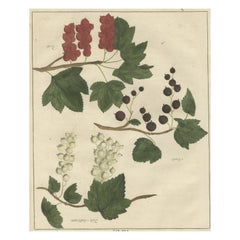
- Antique Hand-Colored Print of Currants, 1758Located in Langweer, NLAntique print of white, black and red currants. Originates from 'Pomologia' by J. H. Knoop. Artists and Engravers: Published by Johann Hermann Knoop (c.1700-1769). Condition: G...Category
Antique 18th Century Maps
MaterialsPaper
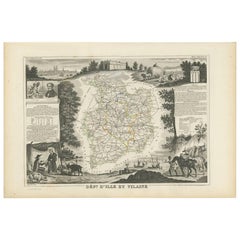
- Antique Map of Ille et Vilaine ‘France’ by V. Levasseur, 1854Located in Langweer, NLAntique map titled 'Dépt. d'Ille et Vilaine'. Map of the French department of Ille et Vilaine. France. Its coastal area is famous for its seafood, and especially its oysters. The reg...Category
Antique Mid-19th Century Maps
MaterialsPaper
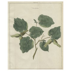
- Antique Hand-Colored Print of the Common Hazel, 1758Located in Langweer, NLAntique print of the common hazel. Originates from 'Pomologia' by J. H. Knoop. Artists and Engravers: Published by Johann Hermann Knoop (c.1700-1769). Condition: Good, general ...Category
Antique 18th Century Maps
MaterialsPaper
You May Also Like
- Staffordshire 1645 Hand Colored Antique Print Staffordiensis Comitatvs MapLocated in GBWe are delighted to offer for sale this lovely antique Atlas page map of Staffordshire printed in 1645 Amsterdam Staffordiensis Comitatvs Vulgo This o...Category
Antique Early 1800s English Georgian Maps
MaterialsPaper
- Double Sided Northamptonshire 1645 Hand Colored Antique Print Map Rare FindLocated in GBWe are delighted to this lovely antique Atlas page map of Northamptonshire printed in 1645 Amsterdam Staffordiensis Comitatvs Vulgo I have three of th...Category
Antique Early 1800s English Georgian Maps
MaterialsPaper
- Double Sided and Glazed Cheshire 1645 Hand Colored Antique Print Map Rare FindLocated in GBWe are delighted to offer for sale this lovely antique Atlas page map of Cheshire printed in 1645 Amsterdam Staffordiensis Comitatvs Vulgo I have thre...Category
Antique Early 1800s English Georgian Maps
MaterialsPaper
- Fine French Antique 1856 Hand Watercolour Map of Dept Des Hautes PyreneesLocated in GBWe are delighted to offer for sale this stunning 1856 hand watercolour map of the Austrian Alps titled Dept Des Hautes Pyrenees taken from the Atlas Nat...Category
Antique 1850s French Early Victorian Maps
MaterialsPaper
- Beautiful Colour French Antique 1856 Hand Watercolour Map of Dept Des La CorseLocated in GBWe are delighted to offer for sale this stunning 1856 hand watercolour map of the Austrian Alps titled Dept Des La Course taken from the Atlas National ...Category
Antique 1850s French Early Victorian Maps
MaterialsPaper
- Fine Antique 1856 Hand Watercolour Map of Dept Des Hautes Alpes by Levasseur'sLocated in GBWe are delighted to offer for sale this stunning 1856 hand watercolour map of the Austrian Alps titled Dept Des Hautes Alpes taken from the Atlas National...Category
Antique 1850s French Early Victorian Maps
MaterialsPaper


Recently Viewed
View AllMore Ways To Browse
Engraved With B
Antique Furniture Dundee
Antique Map Chicago
Antique Map Copenhagen
Antique Map Malta
Antique Map Of Malta
Antique Maps Of Malta
Antique Maps Of Pennsylvania
Antique Queensland
Mitchell Antique Maps
North Carolina Map
Otto Petri
Ottoman Map
Alexandria Map
Antique Bassett Furniture
Antique Furniture Furniture Nova Scotia
Antique Furniture Nova Scotia Furniture
Antique Furniture Nova Scotia