


Antique Map of Mexico by Ortelius, circa 1602
About the Item
- Creator:Abraham Ortelius (Artist)
- Dimensions:Height: 16.93 in (43 cm)Width: 20.87 in (53 cm)Depth: 0.02 in (0.5 mm)
- Materials and Techniques:Paper,Engraved
- Place of Origin:
- Period:Early 17th Century
- Date of Manufacture:circa 1602
- Condition:General age-related toning, some stains. Old hand coloring. Repair and split on folding line. Spanish text on verso. Please study image carefully.
- Seller Location:Langweer, NL
- Reference Number:
Abraham Ortelius
Abraham Ortelius is widely recognized as the inventor of the atlas and one of the most prominent geographers in history. He is one of the best known and most frequently collected of all sixteenth-century mapmakers, and today, hand-colored, copperplate-printed Abraham Ortelius maps continue to command avid interest.
Ortelius was the eldest of the three children of an Antwerp merchant. After his father's death when he was ten, he was raised by his uncle Jacob Van Meteren — a financier and printer of early English versions of the Bible. Ortelius entered the Guild of Saint Luke in 1547 to become a map copier and colorist, but his hobbies overshadowed his studies.
Ortelius was better known as a student of history and a collector of books and old coins than a cartographer — only initially garnering modest praise for his skills at mapmaking. Gleaning what he learned from his uncle, he became a dealer in books and prints. In 1554 he attended the annual Frankfurt Book Fair, where he met the highly respected cartographer Gerardus Mercator.
Ortelius refocused his work in mapmaking after that fateful encounter. He eventually published Theatrum Orbis Terrarum (Theater of the World) — a comprehensive collection of maps that he bound into a book. It was the first of its kind and is now recognized as the first modern-day atlas. While creating his atlas, Ortelius observed that the coast of America shared geometrical similarities with the shores of Europe and Africa. When he lined up maps of the coastlines of the continents, they matched — much like pieces in a jigsaw puzzle.
Some have argued that the concept of continental drift is at least partly rooted in Ortelius’s 16th-century-era suggestion that the continents had once been joined together as a single mass of land before the Americas were pulled away from Europe and Africa. Much later, in 1912, German meteorologist Alfred Wegener proposed in a lecture and an article that the continents had once been locked together based on data he collected. Wegener was widely ridiculed at the time, but the foundation of modern-day science of plate tectonics has its origins in his work.
On May 18, 2008, a Google Doodle celebrated the 300th anniversary of Ortelius’s atlas.
On 1stDibs, find original Abraham Ortelius prints, landscape prints and more.
- ShippingRetrieving quote...Ships From: Langweer, Netherlands
- Return PolicyA return for this item may be initiated within 14 days of delivery.
- Antique Map of Southeast Asia by Ortelius '1587'By Abraham OrteliusLocated in Langweer, NLAntique map titled 'Indiae Orientalis Insularumque Adiacientium Typus'. Ortelius includes early European depictions of both Japan and China and is the first to name Formosa (Taiwan). The Philippines and East Indies or Spice Islands are shown based upon Portuguese and Spanish sources, and before their penetration by the Dutch. Japan is shown in kite form, as a large oval island...Category
Antique 16th Century Maps
MaterialsPaper

- Antique Map of Austria by Ortelius, c.1612Located in Langweer, NLAntique map titled 'Austriae Descrip. per Wolfgangum Lazium' Original antique map of Austria. Published by A. Ortelius, circa 1612. Artists a...Category
Antique 17th Century Maps
MaterialsPaper
- Antique Map of the Region of Salzburg by Ortelius 'circa 1606'Located in Langweer, NLAntique map titled 'Salisburgensis Iurisdictionis'. Original antique map of the region of Salzburg, Austria. Published by A. Ortelius, circa 1606.Category
Antique Early 17th Century Maps
MaterialsPaper
- Antique Map of the Region of Poitou by Ortelius, circa 1600Located in Langweer, NLAntique map titled 'Poictou'. Original antique map of the region of Poitou, a former province of west-central France whose capital city was Poitiers. Published by A. Ortelius, circa ...Category
Antique Early 17th Century Maps
MaterialsPaper
- Antique Map of East Frisia by Ortelius, c.1595Located in Langweer, NLAntique print, titled: 'Frisia Orientalis.' Map of East Frisia originating from 'Theatrum Orbis Terrarum'. It is based on the manuscript map by Jon Bloe...Category
Antique 16th Century Maps
MaterialsPaper
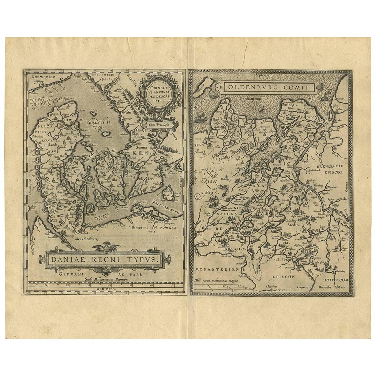
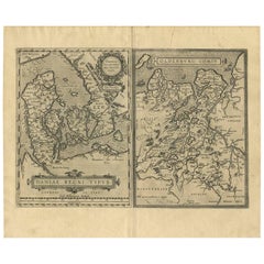
- Antique Map of Denmark and Oldenburg ‘Germany’ by A. Ortelius, circa 1598Located in Langweer, NLAntique map titled 'Daniae Regni Typus' and 'Oldenburg Comit'. A nice example of Ortelius maps of Denmark and Oldenburg, which first appeared in the 1584 edition of his Theatrum Orbi...Category
Antique 16th Century Maps
MaterialsPaper


- Original Antique Map of Belgium by Tallis, Circa 1850Located in St Annes, LancashireGreat map of Belgium Steel engraving Many lovely vignettes Published by London Printing & Publishing Co. ( Formerly Tallis ), C.1850 Origin...Category
Antique 1850s English Maps
MaterialsPaper
- Original Antique Map / City Plan of Brussels by Tallis, circa 1850Located in St Annes, LancashireGreat map of Brussels. Steel engraving. Published by London Printing & Publishing Co. (Formerly Tallis), C.1850 Free shipping.Category
Antique 1850s English Maps
MaterialsPaper
- Original Antique Map of South East Asia by Becker, circa 1840Located in St Annes, LancashireGreat map of South East Asia Steel engraving with original color outline Engraved by Becker Published by Virtue, circa 1840. Unframed.Category
Antique 1840s English Other Maps
MaterialsPaper
- Original Antique Map of Spain and Portugal, circa 1790Located in St Annes, LancashireSuper map of Spain and Portugal Copper plate engraving by A. Bell Published, circa 1790. Unframed.Category
Antique 1790s English Other Maps
MaterialsPaper
- Original Antique Map of Russia By Arrowsmith. 1820Located in St Annes, LancashireGreat map of Russia Drawn under the direction of Arrowsmith Copper-plate engraving Published by Longman, Hurst, Rees, Orme and Brown, 1820 Unframed.Category
Antique 1820s English Maps
MaterialsPaper
- Antique Map of Italy by Andriveau-Goujon, 1843By Andriveau-GoujonLocated in New York, NYAntique Map of Italy by Andriveau-Goujon, 1843. Map of Italy in two parts by Andriveau-Goujon for the Library of Prince Carini at Palazzo Carini i...Category
Antique 1840s French Maps
MaterialsLinen, Paper


