Items Similar to Antique Map of the Bay of Batavia by Van der Aa, c.1720


Want more images or videos?
Request additional images or videos from the seller
1 of 5
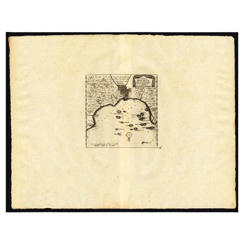
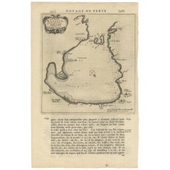
Antique Map of the Bay of Batavia by Van der Aa, c.1720
About the Item
Antique map titled 'La Rade de Batavia'. A small early 18th century black and white map of the Bay of Batavia (Jakarta), Indonesia. Published by P. van der Aa, circa 1720. Artists and Engravers: Apprenticed at the age of 9, Van der Aa began his career at Leiden in 1683 as a Latin trade publisher, publishing classical texts pertaining to medicine and science. Later on, he became an engraver and publisher of atlases and maps in Leiden. His publications include an ?Atlas Nouveau? completed in about 1710, and the famous La Galerie Agréable du Monde ? one of the most impressive geographical books printed in 66 volumes in limited edition. It contains around 3000 plates, and cover the topography and people of Europe, Asia, Africa and America.
Artist: Apprenticed at the age of 9, Van der Aa began his career at Leiden in 1683 as a Latin trade publisher, publishing classical texts pertaining to medicine and science. Later on, he became an engraver and publisher of atlases and maps in Leiden. His publications include an ?Atlas Nouveau? completed in about 1710, and the famous La Galerie Agréable du Monde ? one of the most impressive geographical books printed in 66 volumes in limited edition. It contains around 3000 plates, and cover the topography and people of Europe, Asia, Africa and America.
Condition: Good, general age-related toning and/or occasional minor defects from handling. Please study scan carefully.
Date: c.1720
Overall size: 19.8 x 30.4 cm
Image size: 0.001 x 16.1 x 16.2 cm
Antique prints have long been appreciated for both their aesthetic and investment value. They were the product of engraved, etched or lithographed plates. These plates were handmade out of wood or metal, which required an incredible level of skill, patience and craftsmanship. Whether you have a house with Victorian furniture or more contemporary decor an old engraving can enhance your living space. We offer a wide range of authentic antique prints for any budget.
- Dimensions:Height: 11.97 in (30.4 cm)Width: 7.8 in (19.8 cm)Depth: 0 in (0.01 mm)
- Materials and Techniques:
- Period:
- Date of Manufacture:circa 1720
- Condition:
- Seller Location:Langweer, NL
- Reference Number:
About the Seller
5.0
Platinum Seller
These expertly vetted sellers are 1stDibs' most experienced sellers and are rated highest by our customers.
Established in 2009
1stDibs seller since 2017
1,965 sales on 1stDibs
Typical response time: <1 hour
- ShippingRetrieving quote...Ships From: Langweer, Netherlands
- Return PolicyA return for this item may be initiated within 14 days of delivery.
More From This SellerView All
- Antique Map of the City of Batavia by Van der Aa 'c.1730'Located in Langweer, NLAntique map titled 'Plan de la Ville et du Chateau de Batavia en l'Isle de Iava - Ware affbeeldinge wegens het Casteel ende Stadt Batavia gelegen op groot Eylant Java'. Detailed plan...Category
Antique Mid-18th Century Maps
MaterialsPaper
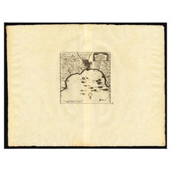
- Antique Map of the Roadstead of Batavia by Van der Aa, 1725By Pieter Van Der AaLocated in Langweer, NLAntique map titled 'La rade de Batavia'. (The roadstead of Batavia.) This map shows the roadstead before the Indonesian city of Batavia, nowadays Jakarta. This plate originates from ...Category
Antique 18th Century Maps
MaterialsPaper
- Antique Map of Peru by van der Aa, 'circa 1720'Located in Langweer, NLAntique map titled 'Le Perou, Grand Pays de l Amerique Meridionale (..)'. Decorative map of Peru including portions of Ecuador and northern Chile and Boliv...Category
Antique Early 18th Century Maps
MaterialsPaper
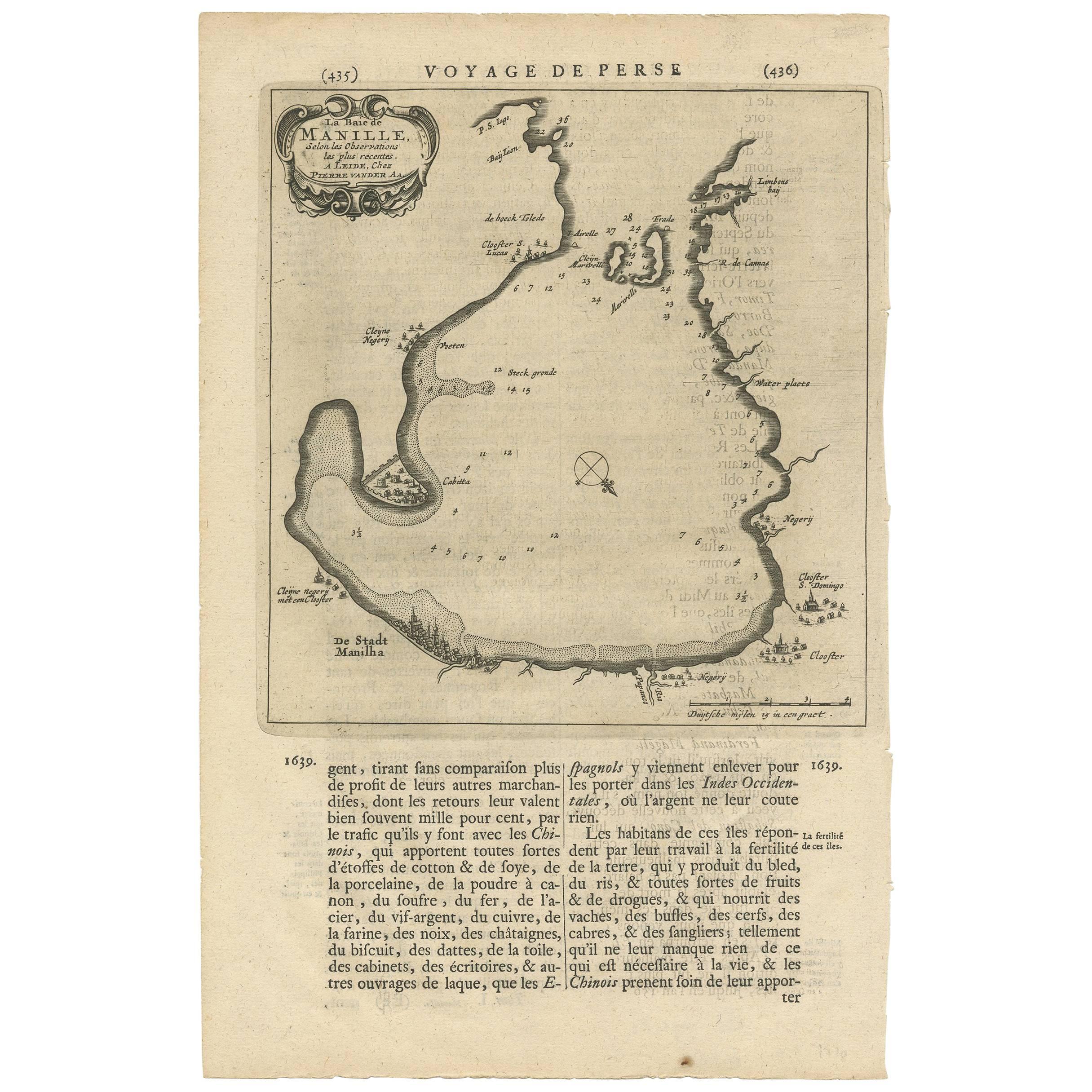
- Antique Map of Manilla Bay Philippines by P. van der Aa, 1719Located in Langweer, NLRare antique map titled 'La Baie de Manille (..)'. Map of Manilla Bay, the map is oriented with southwest at the top and includes a small town plan for Manilla and other places. This...Category
Antique Early 18th Century Maps
MaterialsPaper
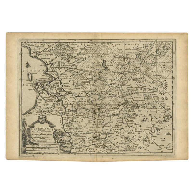
- Antique Map of Overijssel by Van der Aa, c.1715Located in Langweer, NLAntique map titled 'L'Over-Issel'. This map depicts the Dutch province Overijssel. This map originates from 'Nouvel Atlas, très exact et fort commode pour toutes sortes de personnes,...Category
Antique 18th Century Maps
MaterialsPaper
- Antique Map of the Maluku Islands by Van der Aa, 1714By Pieter Van Der AaLocated in Langweer, NLAntique Map Moluccas titled 'Les Isles Moluques'. Rare map of the Spice Islands made after a map engraved by Pieter van den Keere and published in the 1628 edition of the Mercator At...Category
Antique 18th Century Maps
MaterialsPaper


You May Also Like
- London AA MapLocated in Alton, GBLondon AA map.Category
20th Century Maps
MaterialsPaper
- 1861 Topographical Map of the District of Columbia, by Boschke, Antique MapLocated in Colorado Springs, COPresented is an original map of Albert Boschke's extremely sought-after "Topographical Map of the District of Columbia Surveyed in the Years 1856 ...Category
Antique 1860s American Historical Memorabilia
MaterialsPaper
- Antique Coaching Road Map, Devon, English, Regional Cartography, Georgian, 1720Located in Hele, Devon, GBThis is an antique coaching road map of Devon. An English, framed lithograph engraving of regional interest, dating to the early 18th century and later. Fascinating 18th century hig...Category
Antique Early 18th Century British Georgian Maps
MaterialsWood
- 1856 U.S. Coast Survey Map of Chesapeake Bay and Delaware BayLocated in Colorado Springs, COPresented is U.S. Coast Survey nautical chart or maritime map of Chesapeake Bay and Delaware Bay from 1856. The map depicts the region from Susquehanna, Maryland to the northern Outer Banks in North Carolina. It also shows from Richmond and Petersburg, Virginia to the Atlantic Ocean. The map is highly detailed with many cities and towns labeled throughout. Rivers, inlets, and bays are also labeled. Various charts illustrating more specific parts of the region are marked on the map using dotted lines. The lines form boxes, and the corresponding chart number and publication date are given. Extensive triangulation surveys were conducted the length of Chesapeake Bay and are illustrated here. Hampton Roads, Virginia is labeled, along with the James, York, and Rappahannock Rivers, which were all extensively surveyed. The chart was published under the supervision of A. D. Bache, one of the most influential and prolific figures in the early history of the U.S. Coast Survey, for the 1856 Report of the Superintendent of the U.S. Coast Survey. Alexander Dallas Bache (1806-1867) was an American physicist, scientist, and surveyor. Bache served as the Superintendent of the U.S. Coast Survey from 1843 to 1865. Born in Philadelphia, Bache toured Europe and composed an important treatise on European Education. He also served as president of Philadelphia's Central High School and was a professor of natural history and chemistry at the University of Pennsylvania. Upon the death of Ferdinand Rudolph Hassler, Bache was appointed Superintendent of the United States Coast Survey. The Office of the Coast Survey, founded in 1807 by President Thomas Jefferson and Secretary of Commerce Albert Gallatin...Category
Antique 1850s American Maps
MaterialsPaper
- Antique Coach Road Map, East Devon, English, Framed, Cartography, Georgian, 1720Located in Hele, Devon, GBThis is an antique coach road map of East Devon. An English, framed lithograph engraving of regional interest, dating to the early 18th century and later. Fascinating 18th century h...Category
Antique Early 18th Century British Georgian Maps
MaterialsWood
- The Last Flowering of the Middle Ages by Baron Van Der Elst, Stated 1st EdLocated in valatie, NYThe Last Flowering of the Middle Ages by Baron Joseph Van Der Elst. Published by Doubleday, Doran and Company Inc., 1944. Stated 1st Ed hardcover. An in-depth look into art of the Middle Ages. Contents: 1. The Times and the Men who Made Them: Men of Flanders; The Flemish Parade; The Good Black Earth; The Rise of the Towns; The Medieval Guilds; Of Love, the Dream; The Upward Glance; Pt. 2. The Flemish Masters: Jan van Eyck; Petrus Christus...Category
Vintage 1940s American Books
MaterialsPaper


Recently Viewed
View AllMore Ways To Browse
Bay Antique Furniture
Batavia Furniture
Old Maps Of Europe
Latin America Antique
Map Monde Antique
Atlas Du Monde Antique
Victorian Medicine
Map Tibet
Nautical Charts
Antique Furniture Malaysia
Antique Map Of Egypt
Malaysian Antique Furniture
Map Of Singapore
Singapore Map
Antique Farm Antiques Collectibles
Antique Farm Collectables
Antique Farm Collectibles
Hemisphere World Map