Items Similar to Antique Map of the Holy City Jerusalem in Israël, c.1700

Want more images or videos?
Request additional images or videos from the seller
1 of 5
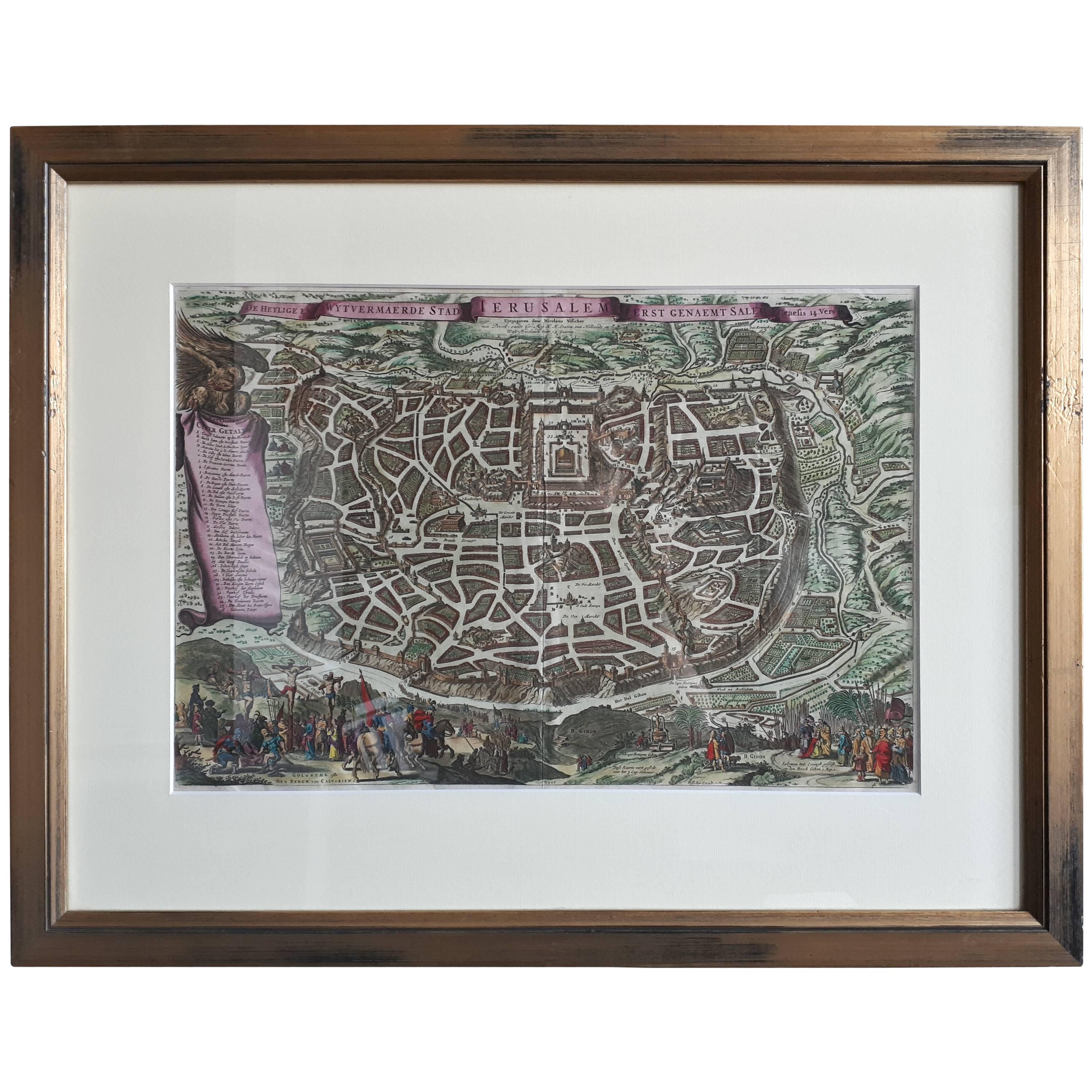
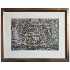
Antique Map of the Holy City Jerusalem in Israël, c.1700
About the Item
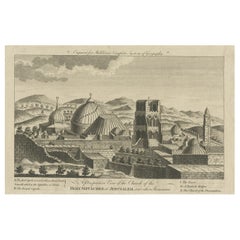
Antique map of the Holy City titled 'De Stadt Ierusalem'.
Rare state of this bird's eye plan of the holy city flanked by engravings of religious icons. At the bottom are an elevation of the Temple of Solomon and a panoramic view of Jerusalem. The subtitle reads 't'Amsterdam uyt gegeven door Cornelis Danckerts voor aen op de Nieuwendyck in den Atlas met Previlegie'.
Artists and Engravers: Published by C. Danckerts II. The Danckerts were a well known family containing several engravers, cartographers and print-sellers that started with the founder Cornelis Danckerts I (1536-1595) who was the city carpenter.
Artist: Published by C. Danckerts II. The Danckerts were a well known family containing several engravers, cartographers and print-sellers that started with the founder Cornelis Danckerts I (1536-1595) who was the city carpenter.
Condition: Fair, several repairs mainly on folding lines. Dutch text on verso, faded. Please study image carefully.
Date: c.1700
Overall size: 54 x 41.5 cm.
Image size: 50 x 34.5 cm.
- Dimensions:Height: 21.26 in (54 cm)Width: 16.34 in (41.5 cm)Depth: 0 in (0.01 mm)
- Materials and Techniques:
- Period:
- Date of Manufacture:circa 1700
- Condition:Repaired: Several repairs mainly on folding lines. Condition: Fair, several repairs mainly on folding lines. Dutch text on verso, faded. Please study image carefully.
- Seller Location:Langweer, NL
- Reference Number:
About the Seller
5.0
Platinum Seller
These expertly vetted sellers are 1stDibs' most experienced sellers and are rated highest by our customers.
Established in 2009
1stDibs seller since 2017
1,965 sales on 1stDibs
Typical response time: <1 hour
- ShippingRetrieving quote...Ships From: Langweer, Netherlands
- Return PolicyA return for this item may be initiated within 14 days of delivery.
More From This SellerView All
- Antique Map of the City of Jerusalem by N. Visscher, 1702Located in Langweer, NLAntique map titled 'Die Heylige en Wytvermaerde stadt Jerusalem Eerst Genaemt Salem, Genesis 14 vers 18'. This map originates from 'Biblia. Ouden ende Nieuwen Testaments (..)'. Publi...Category
Antique Early 18th Century Maps
MaterialsPaper
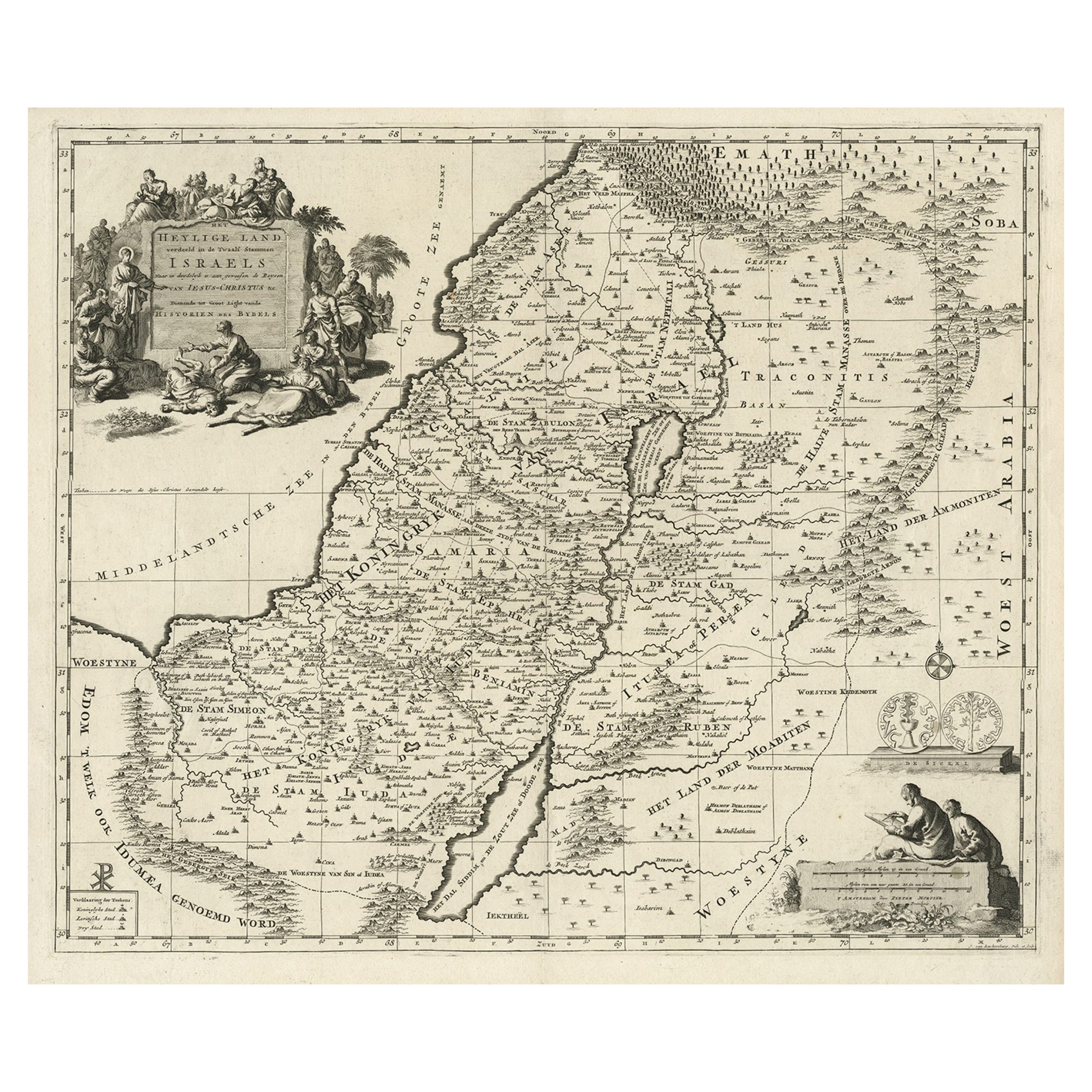
- Highly Detailed Antique Map of the Holy Land Showing 12 Tribes of Israel, c.1720Located in Langweer, NLAntique map titled 'Heylige Land verdeeld in de Twaalf Stammen Israels (..).' Highly detailed map of the Holy Land divided into 12 tribes of Israel...Category
Antique 1720s Maps
MaterialsPaper
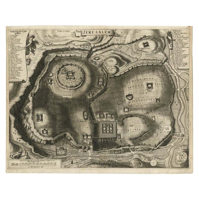
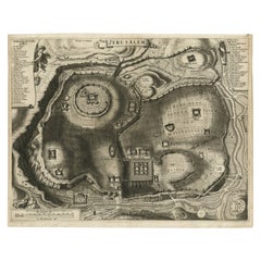
- Antique Detailed Map of Jerusalem in Israël with Extensive Key and Scale, 1698Located in Langweer, NLAntique map titled 'Jerusalem.' Plan of the ancient city of Jerusalem. With extensive key and scale. Source unknown, to be determined. Artists and Engravers: Made by 'Cornelis de...Category
Antique 17th Century Maps
MaterialsPaper
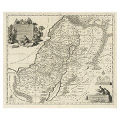
- Antique Map of the Holy Land, c.1717Located in Langweer, NLAntique map Israel titled 'Tabula Geographica Terrae Sanctae'. Rare edition made after a map of the Holy Land by J. Bonfrerius. The map is oriented ...Category
Antique 18th Century Maps
MaterialsPaper
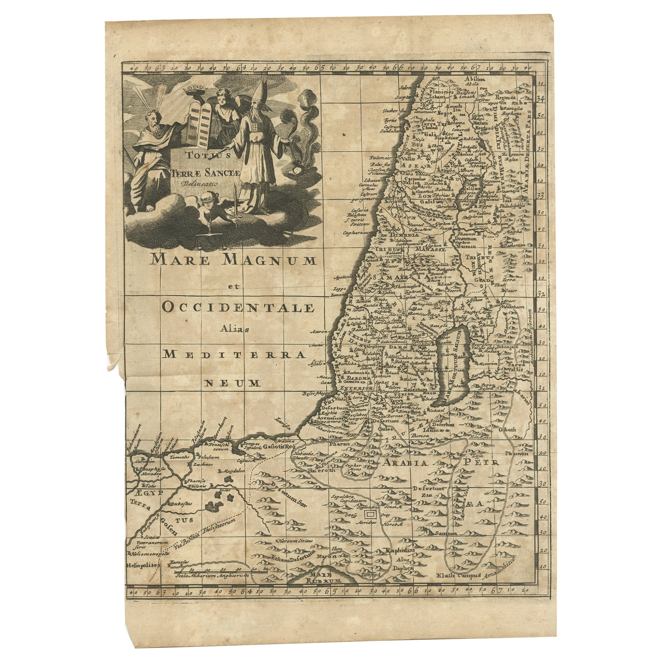
- Antique Map of the Holy Land, c.1710Located in Langweer, NLAntique map titled 'Totius Terrae Sanctae Delineatio'. Map of the Holy Land extending to Egypt and showing the route of the Children of Israel in their e...Category
Antique 18th Century Maps
MaterialsPaper
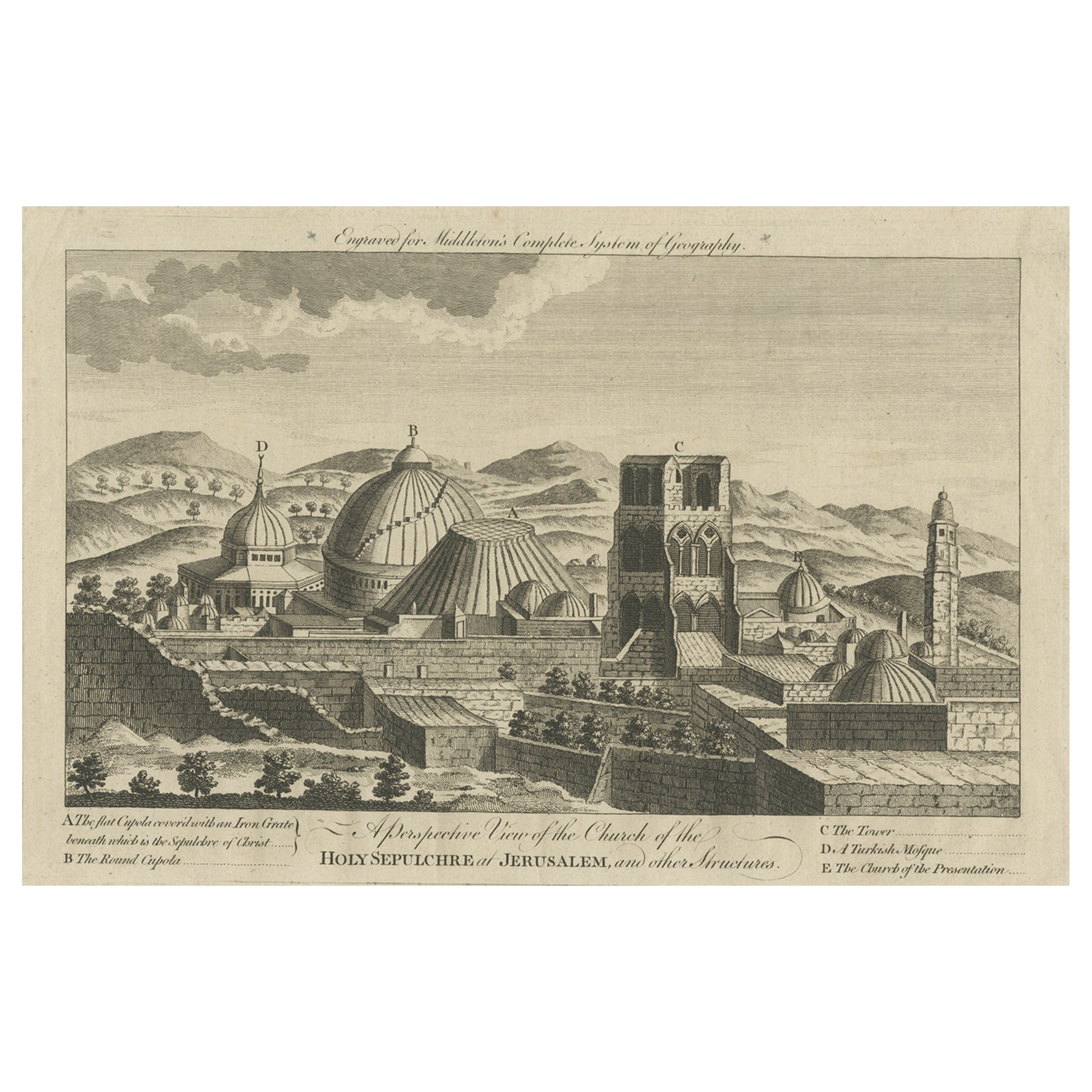
- Antique View of the Holy Sepulchre Church in Jerusalem, Ca.1778Located in Langweer, NLDescription: Antique print titled 'A perspective View of the Church of the Holy Sepulchre at Jerusalem and other Structures'. A view of the Holy Sep...Category
Antique 1770s Prints
MaterialsPaper


You May Also Like
- Antique Map of American Cities, Vignette of New York City, circa 1920Located in St Annes, LancashireGreat maps of American Cities Unframed Original color By John Bartholomew and Co. Edinburgh Geographical Institute Published, circa 1920Category
Vintage 1920s British Maps
MaterialsPaper
- Italian Parchment Map of the City of Pisa Dated, 1640By Matthäus Merian the ElderLocated in Roma, ITAn antique map of the Tuscan city of Pisa engraved for The 'Itinerarium Italiæ Nov-antiquæ' by Matthäus Merian the Elder and printed in 1640....Category
Antique 1640s Italian Maps
MaterialsPaper
- Large Original Vintage Map of Israel, circa 1920Located in St Annes, LancashireGreat map of Israel Original color. Good condition Published by Alexander Gross Unframed.Category
Vintage 1920s English Edwardian Maps
MaterialsPaper
- 1840 Map of the City of Washington Published by William M. MorrisonLocated in Colorado Springs, COThis map, printed in 1840, is a detailed representation of Washington, D.C. in the mid-19th century. The map shows block numbers, wards, and government buildings as well as details o...Category
Antique 1840s American Federal Maps
MaterialsPaper
- The Holy Land at the Time of Jesus: A 17th Century Dutch Map by VisscherBy Nicolaes Visscher IILocated in Alamo, CAThis detailed Dutch map entitled "Het Beloofe de Landt Canaan door wandelt van onsen Salichmaecker Iesu Christo, nessens syne Apostelen" by Nicolaes Visscher was published in Amsterd...Category
Antique Mid-17th Century Dutch Maps
MaterialsPaper
- 1861 Topographical Map of the District of Columbia, by Boschke, Antique MapLocated in Colorado Springs, COPresented is an original map of Albert Boschke's extremely sought-after "Topographical Map of the District of Columbia Surveyed in the Years 1856 ...Category
Antique 1860s American Historical Memorabilia
MaterialsPaper


Recently Viewed
View AllMore Ways To Browse
Jerusalem Furniture
Israeli Artist Furniture
18th Century City View
Antique Jerusalem
Antique Israel
Israel Antique
Israeli Antique
Religious Icons
Temple Door
Antique Carpenters
Antique Furniture Israel
Antique Religious Icon
Engravings 1700
Antique Religious Icons
Antique Folding Door
Holy Icon
Birds Eye View Map
Antique Temple Doors