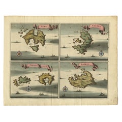
Items Similar to Antique Map of the Islands of Schiatti and Scopoli, Greece, 1687


Want more images or videos?
Request additional images or videos from the seller
1 of 6
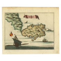
Antique Map of the Islands of Schiatti and Scopoli, Greece, 1687
About the Item
Antique map titled 'Schiatti - Scopoli.' This original antique map shows the islands Schiatti and Scopoli in Greece. Source unknown, to be determined.
Artists and Engravers: Made by 'Olfert Dapper' after an anonymous artist. Olfert Dapper (c. 1635 - 1689) was a Dutch physician and writer. He wrote books about history and geography, although he never travelled outside Holland. Until today, his book Description of Africa (1668) is a key text for Africanists.
Condition: Good, given age. Light vertical crease. General age-related toning and/or occasional minor defects from handling. Please study image carefully.
Date: 1687
Overall size: 20 x 15.5 cm.
Image size: 16.8 x 12.5 cm.
We sell original antique maps to collectors, historians, educators and interior decorators all over the world. Our collection includes a wide range of authentic antique maps from the 16th to the 20th centuries. Buying and collecting antique maps is a tradition that goes back hundreds of years. Antique maps have proved a richly rewarding investment over the past decade, thanks to a growing appreciation of their unique historical appeal. Today the decorative qualities of antique maps are widely recognized by interior designers who appreciate their beauty and design flexibility. Depending on the individual map, presentation, and context, a rare or antique map can be modern, traditional, abstract, figurative, serious or whimsical. We offer a wide range of authentic antique maps for any budget.
- Dimensions:Height: 6.11 in (15.5 cm)Width: 7.88 in (20 cm)Depth: 0 in (0.01 mm)
- Materials and Techniques:
- Period:
- Date of Manufacture:1687
- Condition:Condition: Good, given age. Light vertical crease. General age-related toning and/or occasional minor defects from handling. Please study image carefully.
- Seller Location:Langweer, NL
- Reference Number:
About the Seller
5.0
Platinum Seller
These expertly vetted sellers are 1stDibs' most experienced sellers and are rated highest by our customers.
Established in 2009
1stDibs seller since 2017
1,970 sales on 1stDibs
Typical response time: <1 hour
- ShippingRetrieving quote...Ships From: Langweer, Netherlands
- Return PolicyA return for this item may be initiated within 14 days of delivery.
More From This SellerView All
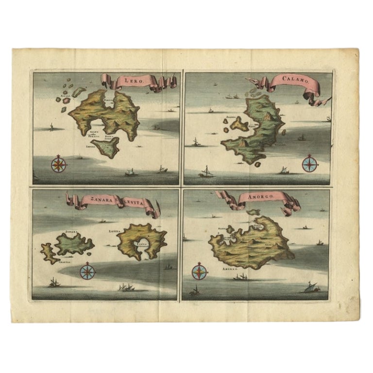
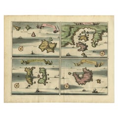
- Original Antique Map of Leros and Kalimnos, and other islands, Greece, 1687Located in Langweer, NLAntique map titled 'Lero, Calamo, Zanara e Levita, Amorgo.' heet with four maps on one page showing the islands Leros, Kalimnos, and other islands, Greece. Source unknown, to be de...Category
Antique 17th Century Maps
MaterialsPaper
- Antique Map of the Island of Tinos by Dapper, 1687Located in Langweer, NLAntique map titled 'Tino.' This original antique map shows the island of Tinos, Greece. Source unknown, to be determined. Artists and Engravers: Made by 'Olfert Dapper' after an a...Category
Antique 17th Century Maps
MaterialsPaper
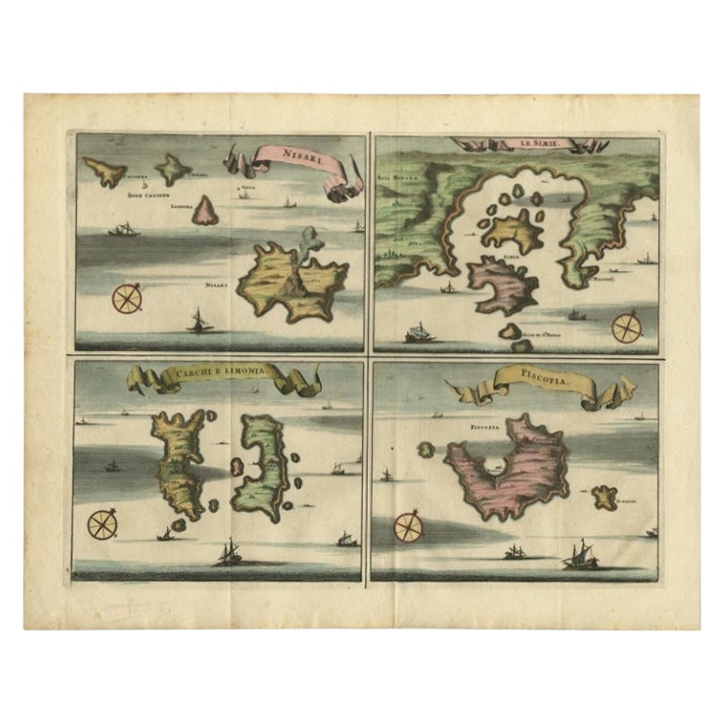
- Antique Map of Nisari, Le Simie, Carchi Elimoia and Piscopia, Greece, 1687Located in Langweer, NLAntique map titled 'Carchi Elimoia, Nisari, Le Simie, Piscopia.' Sheet with four maps on one page showing Nisyros, Simi and other islands, Greece. Source unknown, to be determined. A...Category
Antique 17th Century Maps
MaterialsPaper
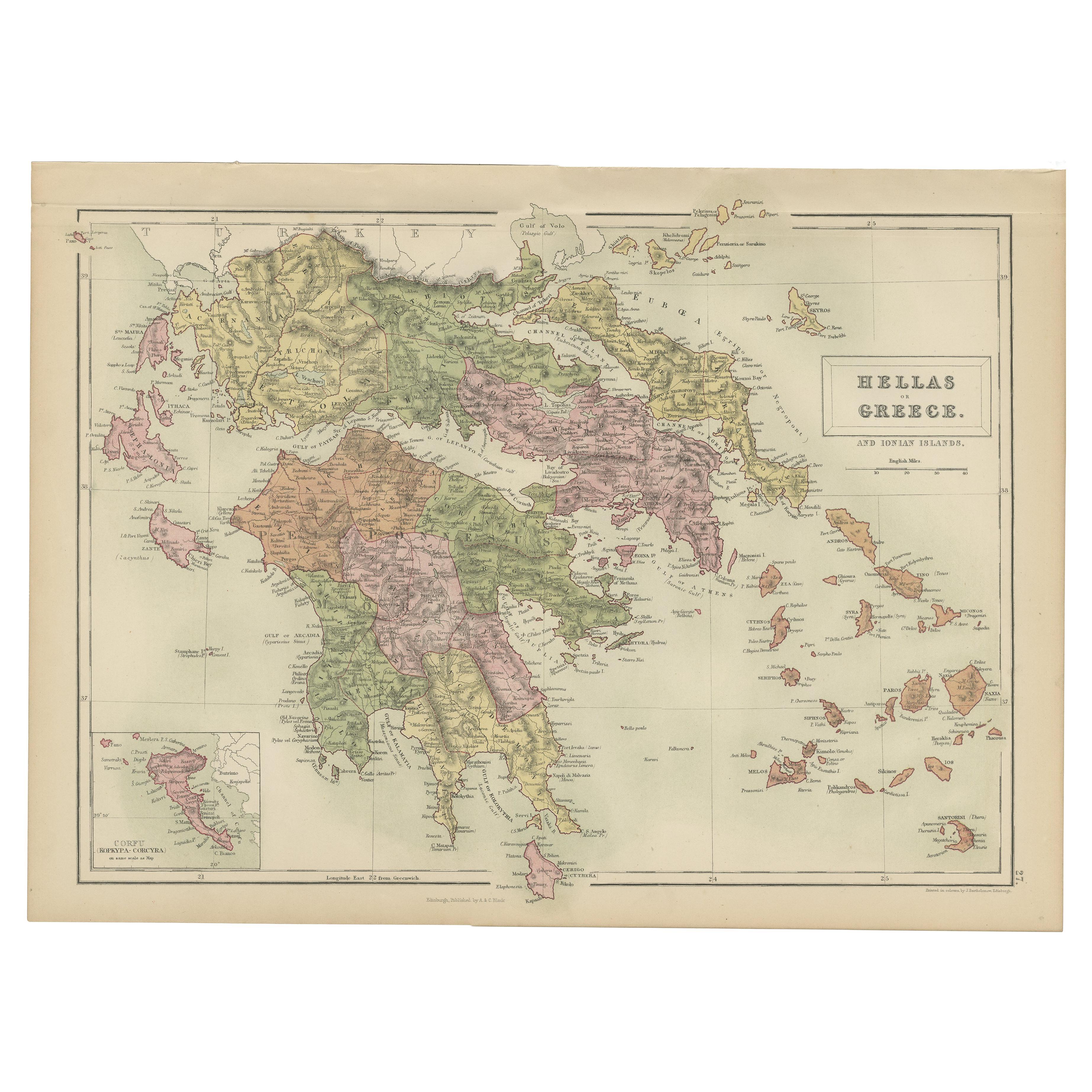
- Antique Map of Greece and Ionian Islands by A & C. Black, 1870Located in Langweer, NLAntique map titled 'Hellas or Greece'. Original antique map of Greece and Ionian Islands with inset map of Corfu. This map originates from ‘Black's General Atlas of The World’. Publi...Category
Antique Late 19th Century Maps
MaterialsPaper
- Antique Map of the Islands Within the Queen Charlotte's IslandsLocated in Langweer, NLAntique map titled 'Cote Septentrional de la plus grande des Isles de la Reine Charlotte (..)'. Map and coastal view of the islands within the Queen Charlotte's Islands (Santa Cruz I...Category
Antique Late 18th Century Maps
MaterialsPaper
- Antique Map of the Atlantic Islands, 1817Located in Langweer, NLAntique map titled 'Atlantic Islands'. Large map of the Atlantic Islands include the Cape Verde islands, Canary islands, Azore islands and Madeira islands. Also included a view of th...Category
Antique Early 19th Century Maps
MaterialsPaper


You May Also Like
- 1854 Map of Massachusetts, Connecticut and Rhode Island, Antique Wall MapLocated in Colorado Springs, COThis striking wall map was published in 1854 by Ensign, Bridgman & Fanning and has both full original hand-coloring and original hardware. This impression is both informative and highly decorative. The states are divided into counties, outlined in red, green, and black, and subdivided into towns. Roads, canals, and railroad lines are prominently depicted, although they are not all labeled. The mapmakers also marked lighthouses, banks, churches, and prominent buildings, with a key at right. The map is an informative and comprehensive overview of the infrastructural development of New England prior to the Civil War. Physical geographies depicted include elevation, conveyed with hachure marks, rivers and lakes. The impression features an inset map of Boston...Category
Antique 19th Century American Maps
MaterialsPaper
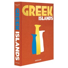
- Greek IslandsBy Assouline PublishingLocated in NEW YORK, NYAn endless expanse of shimmering waters paired with unmatched Greek hospitality awaits visitors to the islands of the Aegean Sea. Each island is home to a unique spirit and mythology. From Patmos (a favorite of Aga Khan) to Hydra (which captivated Henry Miller, Leonard Cohen and Sophia Loren), the islands are imbued with a seductive sense of history, tradition and adventure. Several films over the decades have been filmed on them, including Boy on a Dolphin (1957) on Hydra, The Big Blue (1988) on Amorgos and The Sisterhood of the Traveling Pants (2005) on Santorini. Sources of inspiration for millennia, the ancient ruins, cliffside monasteries and volcanic rims are all can’t-miss sights. Venturing on an Odyssey of their own, the author and the photographer boarded a traditional Greek sailboat and set out to capture the calming atmosphere, quintessential characters and breathtaking architecture of these gems of the Aegean. A spectacular journey re-created in the pages of Greek Islands. Chrysanthos Panas is a businessman, art collector and philanthropist from Athens. He is in the hospitality industry and co-owner, with his brother Spyros, of several well-known clubs and restaurants in Greece, such as Island, Athénée and Salon de Bricolage. He is an expert in destination management and one of the first to use the term “Athens Riviera...Category
2010s American Books
MaterialsLinen
- Large Original Antique Map of Rhode Island, USA, C.1900Located in St Annes, LancashireFabulous map of Rhode Island Original color Engraved and printed by the George F. Cram Company, Indianapolis. Published, C.1900 Unframed Free ...Category
Antique 1890s American Maps
MaterialsPaper
- Original Antique Map of Ancient Greece- Boeotia, Thebes, 1787Located in St Annes, LancashireGreat map of Ancient Greece. Showing the region of Boeotia, including Thebes Drawn by J.D. Barbie Du Bocage Copper plate engraving by P.F T...Category
Antique 1780s French Other Maps
MaterialsPaper
- Original Antique Map of Ancient Greece, Achaia, Corinth, 1786Located in St Annes, LancashireGreat map of Ancient Greece. Showing the region of Thessaly, including Mount Olympus Drawn by J.D. Barbie Du Bocage Copper plate engraving by P.F Tardieu Original hand color...Category
Antique 1780s French Other Maps
MaterialsPaper
- Large Original Vintage Map of The Pacific Islands Including HawaiiLocated in St Annes, LancashireGreat map of The Pacific Islands Unframed Original color By John Bartholomew and Co. Edinburgh Geographical Institute Published, circa 1...Category
Vintage 1920s British Maps
MaterialsPaper


Recently Viewed
View AllMore Ways To Browse
Keys Collectible Antique
Greek Key Handle
Greek Key Light
Antique Stand Up Scale
Antique Railroad Collectables
Antique Railroad Collectibles Collectibles
Antique Railroad Collectibles
Maps Of Georgia
South Africa Antique Map
Antique Georgia Map
Antique Georgia Maps
Map Nautical Chart
Map New Amsterdam
18th Century Antique Mexican
Albanian Antique
East Africa Map
Antique Map Brazil
Antique Map Of Brazil