Objekte ähnlich wie Antike Karte der Coiba-Insel, Panama, Südamerika, um 1740


Möchten Sie mehr Bilder oder Videos?
Zusätzliche Bilder oder Videos von dem*der Anbieter*in anfordern
1 von 6
Antike Karte der Coiba-Insel, Panama, Südamerika, um 1740
272 €Einschließlich MwSt.
340 €20 % Rabatt
Versand
Angebot wird abgerufen …Das Versprechen von 1stDibs:
Authentizitätsgarantie,
Geld-Zurück-Garantie,
Stornierung innerhalb von 24 Stunden
Angaben zum Objekt
Antique map titled 'Plan de la partie orientale de l'Isle de Quibo'. Map of the eastside of Coiba Island (Quibo), Panama, showing the shoreline around Port de Dames indicating soft sand and mud, salt lagoons, fresh water, and fisherman's huts. Also marked are the islands of Quiveta and Canales. Source unknown, to be determined.
Artists and Engravers: George Anson, 1st Baron Anson PC, FRS, RN (1697 -1762) was a British admiral and a wealthy aristocrat, noted for his circumnavigation of the globe and his role overseeing the Royal Navy during the Seven Years' War.
Condition:
Very good, please study image carefully.
Date: c.1740
Overall size: 40.1 x 25.3 cm.
Image size: 36.7 x 20.3 cm.
We sell original antique maps to collectors, historians, educators and interior decorators all over the world. Our collection includes a wide range of authentic antique maps from the 16th to the 20th centuries. Buying and collecting antique maps is a tradition that goes back hundreds of years. Antique maps have proved a richly rewarding investment over the past decade, thanks to a growing appreciation of their unique historical appeal. Today the decorative qualities of antique maps are widely recognized by interior designers who appreciate their beauty and design flexibility. Depending on the individual map, presentation, and context, a rare or antique map can be modern, traditional, abstract, figurative, serious or whimsical. We offer a wide range of authentic antique maps for any budget.
- Maße:Höhe: 25,3 cm (9,97 in)Breite: 40,1 cm (15,79 in)Tiefe: 0,01 mm (0 in)
- Materialien und Methoden:
- Zeitalter:
- Herstellungsjahr:circa 1740
- Zustand:Very good, please study image carefully.
- Anbieterstandort:Langweer, NL
- Referenznummer:Anbieter*in: BG-112891stDibs: LU3054329626352
Anbieterinformationen
5,0
Anerkannte Anbieter*innen
Diese renommierten Anbieter*innen sind führend in der Branche und repräsentieren die höchste Klasse in Sachen Qualität und Design.
Platin-Anbieter*in
Premium-Anbieter*innen mit einer Bewertung über 4,7 und 24 Stunden Reaktionszeit
Gründungsjahr 2009
1stDibs-Anbieter*in seit 2017
2.494 Verkäufe auf 1stDibs
Typische Antwortzeit: 1 Stunde
- VersandAngebot wird abgerufen …Versand von: Langweer, Niederlande
- Rückgabebedingungen
Einige Inhalte dieser Seite wurden automatisch übersetzt. Daher kann 1stDibs nicht die Richtigkeit der Übersetzungen garantieren. Englisch ist die Standardsprache dieser Website.
Authentizitätsgarantie
Im unwahrscheinlichen Fall eines Problems mit der Echtheit eines Objekts kontaktieren Sie uns bitte innerhalb von 1 Jahr für eine volle Rückerstattung. DetailsGeld-Zurück-Garantie
Wenn Ihr Objekt nicht der Beschreibung entspricht, beim Transport beschädigt wurde oder nicht ankommt, kontaktieren Sie uns bitte innerhalb von 7 Tagen für eine vollständige Rückerstattung. DetailsStornierung innerhalb von 24 Stunden
Sie können Ihren Kauf jederzeit innerhalb von 24 Stunden stornieren, ohne jegliche Gründe dafür angeben zu müssen.Geprüfte Anbieter*innen
Unsere Anbieter*innen unterliegen strengen Dienstleistungs- und Qualitätsstandards, wodurch wir die Seriosität unserer Angebote gewährleisten können.Preisgarantie
Wenn Sie feststellen, dass ein*e Anbieter*in dasselbe Objekt anderswo zu einem niedrigeren Preis anbietet, werden wir den Preis entsprechend anpassen.Zuverlässige weltweite Lieferung
Unsere erstklassigen Versandunternehmen bieten spezielle Versandoptionen weltweit, einschließlich individueller Lieferung.Mehr von diesem*dieser Anbieter*in
Alle anzeigenAntike Karte der Coiba-Insel von Anson '1749'
Antike Karte mit dem Titel 'Plan van de Oost-Zyde van het Eiland Quibo'. Originale antike Karte der Ostseite der Insel Coiba (Quibo), Panama, mit der Küstenlinie um Port de Dames, di...
Kategorie
Antik, Mitte des 18. Jahrhunderts, Landkarten
Materialien
Papier

200 € Angebotspreis
20 % Rabatt
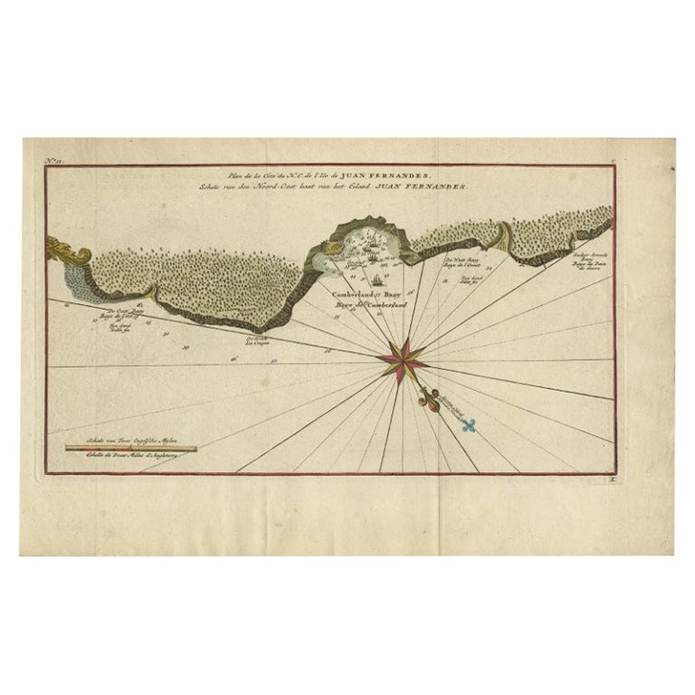
Antike Karte der Insel Juan Fernandez von Anson, um 1740
Antike Karte mit dem Titel 'Plan de la Côte du N.E. de l 'Ile de Juan Fernandes'.
Karte der Nordostküste der Insel Juan Fernandez mit Cumberland Bay, Südamerika. 1740 stach Anson a...
Kategorie
Antik, 18. Jahrhundert, Landkarten
Materialien
Papier

192 € Angebotspreis
20 % Rabatt
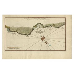
Juan Fernandez Inselkarte - Antike Chilenische Karte um 1750
Antike Karte mit dem Titel 'Plan de la Côte du N.E. de l 'Ile de Juan Fernandes'.
Karte der Nordostküste der Insel Juan Fernandez mit Cumberland Bay, Südamerika. 1740 stach Anson a...
Kategorie
Antik, 18. Jahrhundert, Landkarten
Materialien
Papier
280 € Angebotspreis
20 % Rabatt
Antike Karte von Guadelupe in der Karibik, 1759
Von Jacques-Nicolas Bellin
Antike Karte mit dem Titel 'Carte De L'Isle De La Guadeloupe'. Detaillierte Karte von Guadalupe, Mari-Galante und den Isles de Saintes. Produziert von Nichlas Bellin für Prevost d'Ex...
Kategorie
Antik, Mitte des 18. Jahrhunderts, Französisch, Landkarten
Materialien
Papier

Antike Karte des Hafens von Zihuatanejo in Mexiko, um 1740
Antike Karte mit dem Titel 'Plan du Port de Chequetan ou Seguataneo'. Karte des mexikanischen Hafens von Zihuatanejo. Dieses Gebiet wurde ursprünglich Cihuatlán genannt, was auf Azte...
Kategorie
Antik, 18. Jahrhundert, Landkarten
Materialien
Papier
Antike Karte von Guadeloupe, Insel in der Karibik, um 1757
Antike Karte mit dem Titel 'Carte de L'Isle de la Guadeloupe'.
Eine sehr dekorative Karte von Guadeloupe in der Karibik, verziert mit Loxodromen, Fleur-de-Lys und zwei dekorativen ...
Kategorie
Antik, 18. Jahrhundert, Landkarten
Materialien
Papier

528 € Angebotspreis
20 % Rabatt
Das könnte Ihnen auch gefallen
Westafrikanische Westküste, Guinea und Sierra Leone: Eine Karte aus dem 18. Jahrhundert von Bellin
Von Jacques-Nicolas Bellin
Die Kupferstichkarte von Jacques Bellin mit dem Titel "Partie de la Coste de Guinee Dupuis la Riviere de Sierra Leona Jusquau Cap das Palmas", die die Küste von Guinea und Sierra Leo...
Kategorie
Antik, Mitte des 18. Jahrhunderts, Französisch, Landkarten
Materialien
Papier

Originale antike Karte von Südamerika. C.1780
Großartige Karte von Südamerika
Kupferstich
Veröffentlicht C.1780
Zwei kleine Wurmlöcher auf der linken Seite der Karte
Ungerahmt.
Kategorie
Antik, Anfang 1800, Englisch, Georgian, Landkarten
Materialien
Papier

St. Christophe „St. Kitts“ Insel: Eine handkolorierte Karte von Bellin aus dem 18. Jahrhundert
Von Jacques-Nicolas Bellin
Jacques Bellins Kupferstichkarte der Karibikinsel Saint Kitts mit dem Titel "Carte De De l'Isle St. Christophe Pour servir á l'Histoire Genle. des Voyages Par M. B. Ingr. de la Marin...
Kategorie
Antik, Mitte des 18. Jahrhunderts, Französisch, Landkarten
Materialien
Papier

Kapitän Cooks Erkundung von Tahiti 18. C. Handkolorierte Karte von Bellin
Von Jacques-Nicolas Bellin
Diese schöne handkolorierte Kupferstichkarte aus dem 18. Jahrhundert trägt den Titel "Carte de l'Isle de Taiti, par le Lieutenant J. Cook" und wurde von Jacques Nicolas Bellin gescha...
Kategorie
Antik, Mitte des 18. Jahrhunderts, Französisch, Landkarten
Materialien
Papier

Kalifornien, Alaska und Mexiko: Handkolorierte Karte von de Vaugondy aus dem 18. Jahrhundert
Von Didier Robert de Vaugondy
Diese handkolorierte Karte der westlichen Teile Nordamerikas aus dem 18. Jahrhundert trägt den Titel "Carte de la Californie et des Pays Nord-Ouest separés de l'Asie par le détroit d...
Kategorie
Antik, 1770er, Französisch, Landkarten
Materialien
Papier

Westafrika mit dem Titel „Guinea Propria“: Eine handkolorierte Homann-Karte aus dem 18. Jahrhundert
Von Johann Baptist Homann
Dies ist eine seltene, reich kolorierte Kupferstichkarte von Afrika mit dem Titel "Guinea Propria, nec non Nigritiae vel Terrae Nigrorum Maxima Pars" von Johann Baptist Homann (1664-...
Kategorie
Antik, Mitte des 18. Jahrhunderts, Deutsch, Landkarten
Materialien
Papier
