Objekte ähnlich wie Antique Map of Piedmont, Savoy and Liguria by Justus Danckerts, Amsterdam c.1690


Möchten Sie mehr Bilder oder Videos?
Zusätzliche Bilder oder Videos von dem*der Anbieter*in anfordern
1 von 11
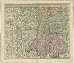
Antique Map of Piedmont, Savoy and Liguria by Justus Danckerts, Amsterdam c.1690
850 €Einschließlich MwSt.
Angaben zum Objekt
Map of Piedmont, Savoy and Liguria by Justus Danckerts, Amsterdam c.1690
This richly detailed and decorative map, titled *Tabula Generalis Ducatus Sabaudiae Principatus Pedemontii Comitatum Nicaeensis et Ducatus Montisferrati*, was published around 1690 by the Amsterdam cartographer Justus Danckerts (Iustinus Danckerus). He was one of the leading mapmakers in the Netherlands during the late 17th century, part of a family renowned for producing finely engraved and colored maps.
The map covers a large swath of Northern Italy and parts of southeastern France, focusing on the Duchy of Savoy, the Principality of Piedmont, the County of Nice, and the Ligurian coast, including Genoa. It reflects the strategic and political importance of these territories, especially during a time of shifting alliances and ongoing wars among European powers.
Danckerts’s map stands out for its clarity and precision, showing a dense network of cities, rivers, mountain ranges, and territorial boundaries. The Alps are rendered in expressive hachuring, and each region is outlined in hand-applied color. Prominent cities such as Turin, Nice, and Genoa are labeled, as well as key geographic features like Lake Geneva, the Po River, and the Mediterranean coast.
A beautifully ornate cartouche at the lower right features allegorical figures, coats of arms, and a dedication, highlighting the grandeur and authority of the map. The artistry and execution are typical of Dutch Golden Age cartography—both practical and decorative.
This map would have served as an important reference for military strategists, diplomats, and merchants operating in this politically significant region at the crossroads of France and Italy.
Condition summary:
Very good condition with original hand-color, central fold as issued, mild age toning. Strong impression but tight margins and some borders reinforced. A fine example of late 17th-century Dutch cartography.
Framing tips:
Best displayed in a dark wood or gold-leaf frame with a cream or soft beige mat to bring out the color contrast. Use UV-protective glass to preserve the hand-coloring and paper integrity over time.
- Maße:Höhe: 52 cm (20,48 in)Breite: 60,6 cm (23,86 in)Tiefe: 0,2 mm (0,01 in)
- Materialien und Methoden:Papier,Graviert
- Zeitalter:Spätes 17. Jahrhundert
- Herstellungsjahr:circa 1690
- Zustand:Neu lackiert. Very good condition with original hand-color, central fold as issued, mild age toning. Strong impression but tight margins and some borders reinforced. A fine example of late 17th-century Dutch cartography.
- Anbieterstandort:Langweer, NL
- Referenznummer:Anbieter*in: BG-13732-51stDibs: LU3054345364122
Anbieterinformationen
5,0
Anerkannte Anbieter*innen
Diese renommierten Anbieter*innen sind führend in der Branche und repräsentieren die höchste Klasse in Sachen Qualität und Design.
Platin-Anbieter*in
Premium-Anbieter*innen mit einer Bewertung über 4,7 und 24 Stunden Reaktionszeit
Gründungsjahr 2009
1stDibs-Anbieter*in seit 2017
2.513 Verkäufe auf 1stDibs
Typische Antwortzeit: <1 Stunde
- VersandAngebot wird abgerufen …Versand von: Langweer, Niederlande
- Rückgabebedingungen
Einige Inhalte dieser Seite wurden automatisch übersetzt. Daher kann 1stDibs nicht die Richtigkeit der Übersetzungen garantieren. Englisch ist die Standardsprache dieser Website.
Authentizitätsgarantie
Im unwahrscheinlichen Fall eines Problems mit der Echtheit eines Objekts kontaktieren Sie uns bitte innerhalb von 1 Jahr für eine volle Rückerstattung. DetailsGeld-Zurück-Garantie
Wenn Ihr Objekt nicht der Beschreibung entspricht, beim Transport beschädigt wurde oder nicht ankommt, kontaktieren Sie uns bitte innerhalb von 7 Tagen für eine vollständige Rückerstattung. DetailsStornierung innerhalb von 24 Stunden
Sie können Ihren Kauf jederzeit innerhalb von 24 Stunden stornieren, ohne jegliche Gründe dafür angeben zu müssen.Geprüfte Anbieter*innen
Unsere Anbieter*innen unterliegen strengen Dienstleistungs- und Qualitätsstandards, wodurch wir die Seriosität unserer Angebote gewährleisten können.Preisgarantie
Wenn Sie feststellen, dass ein*e Anbieter*in dasselbe Objekt anderswo zu einem niedrigeren Preis anbietet, werden wir den Preis entsprechend anpassen.Zuverlässige weltweite Lieferung
Unsere erstklassigen Versandunternehmen bieten spezielle Versandoptionen weltweit, einschließlich individueller Lieferung.Mehr von diesem*dieser Anbieter*in
Alle anzeigenAntike Karte Norditalien von F. de Wit, 1690
Eine sehr dekorative Karte mit Genua als Mittelpunkt und den Städten Mailand, Turin, Parma, Cremona usw. Dekorative Titelkartusche oben rechts, fünf Putten halten die Wappen der Regi...
Kategorie
Antik, Spätes 17. Jahrhundert, Landkarten
Materialien
Papier

440 € Angebotspreis
20 % Rabatt
Antike Karte der Schweiz von N. Visscher, um 1690
Antike Karte mit dem Titel "Tabula Geogaphica qua Pars Meridionalis sive Superior Rheni, Mosae, et Mosellae (..)". Herausgegeben von N. Visscher, Amsterdam, um 1690. Zeitgenössische ...
Kategorie
Antik, Spätes 17. Jahrhundert, Landkarten
Materialien
Papier
532 € Angebotspreis
20 % Rabatt
Antike österreichische Karte von F. de Wit, 1690
Antike Karte mit dem Titel 'Circuli Austriaci pars Septentrionalis in qua Archiducatus'. Dekorative und detaillierte Karte von Österreich von F. de Wit.
Kategorie
Antik, Spätes 17. Jahrhundert, Landkarten
Materialien
Papier

Seltene handkolorierte Karte der Region Lyonnais in Frankreich von Frederik De Wit, um 1688
Titel: Seltene handkolorierte Karte der Region Lyonnais von Frederik De Wit um 1688
Beschreibung: Diese wunderschön detaillierte Karte, "Gouvernement General du Lyonnois", zeigt die...
Kategorie
Antik, 1680er, Landkarten
Materialien
Papier

Dekorative Original-Antike Karte von Süddeutschland, um 1730
"Antike Karte mit dem Titel 'Der südwestliche Teil von Deutschland. Enthält die Herrschaftsgebiete der Erzbischöfe und Kurfürsten von Mentz und Trier sowie die der Elec. Pfalz bei Rh...
Kategorie
Antik, 18. Jahrhundert, Landkarten
Materialien
Papier

Antike Karte von Norditalien von Homann Heirs, um 1730
Antike Landkarte mit dem Titel 'Domini Veneti cum vicinis Parma Mutinae, Matuae et Mirandol (..).' Detaillierte Karte von Norditalien von J. B. Homann. Diese Karte zeigt Venedig und ...
Kategorie
Antik, 18. Jahrhundert, Landkarten
Materialien
Papier

416 € Angebotspreis
20 % Rabatt
Das könnte Ihnen auch gefallen
Handkolorierte Karte der Region Lüttich in Belgien aus dem 17. Jahrhundert von Visscher
Von Nicolaes Visscher II
Eine Originalkarte aus dem 17. Jahrhundert mit dem Titel "Leodiensis Episcopatus in omnes Subjacentes Provincias distincté divisusVisscher, Leodiensis Episcopatus" von Nicolaes Vissc...
Kategorie
Antik, Spätes 17. Jahrhundert, Niederländisch, Landkarten
Materialien
Papier

1640 Willem Blaeu Karte mit dem Titel „Contado di molise et principato vltra“, Ric.a003
Von Willem Blaeu
1640 Willem Blaeu Karte mit dem Titel
"Contado di molise et principato vltra,"
Farbig
Ric. a003
Maße: 38 x 49,6 cm und breite Ränder
DBLAEU.
Grafschaft Molise und Princi...
Kategorie
Antik, 17. Jahrhundert, Niederländisch, Landkarten
Materialien
Papier

Handkolorierte Karte einer Region in Westdeutschland aus dem 17. Jahrhundert von Janssonius
Von Johannes Janssonius
Diese attraktive, detailreiche, handkolorierte Karte aus dem 17. Jahrhundert trägt den Titel "Archiepiscopatus Maghdeburgensis et Anhaltinus Ducatus cum terris adjacentibus". Sie wur...
Kategorie
Antik, Mitte 17. Jahrhundert, Niederländisch, Landkarten
Materialien
Papier

Originale antike Karte der Schweiz, eingraviert von Barlow, datiert 1807
Tolle Karte der Schweiz
Kupferstich von Barlow
Herausgegeben von Brightly & Kinnersly, Bungay, Suffolk.
Datiert 1807
Ungerahmt.
Kategorie
Antik, Anfang 1800, Englisch, Landkarten
Materialien
Papier

Handkolorierte Homann-Karte Deutschlands aus dem 18. Jahrhundert, einschließlich Frankfurt und Berlin
Von Johann Baptist Homann
Eine handkolorierte Karte aus dem 18. Jahrhundert mit dem Titel "Tabula Marchionatus Brandenburgici et Ducatus Pomeraniae quae sunt Pars Septentrionalis Circuli Saxoniae Superioris" ...
Kategorie
Antik, Frühes 18. Jahrhundert, Deutsch, Landkarten
Materialien
Papier

Karte der südostasiatischen Balkans aus dem 18. Jahrhundert von Giovanni Maria Cassini
Von Giovanni Maria Cassini
karte aus dem 18. Jahrhundert vom italienischen Kupferstecher Giovanni Maria Cassini (Italien 1745-1824).
Karte des südlichen Balkans: Rom. Handkolorierter und in Kupfer gestochener...
Kategorie
Antik, 18. Jahrhundert, Italienisch, Landkarten
Materialien
Papier

701 € Angebotspreis
36 % Rabatt