Objekte ähnlich wie Frankreich Karte 1757 - Südliche Provinzen von Isaak Tirion in holländischem Kupferstich


Video wird geladen …
Möchten Sie mehr Bilder oder Videos?
Zusätzliche Bilder oder Videos von dem*der Anbieter*in anfordern
1 von 12
Frankreich Karte 1757 - Südliche Provinzen von Isaak Tirion in holländischem Kupferstich
390 €Einschließlich MwSt.
Angaben zum Objekt
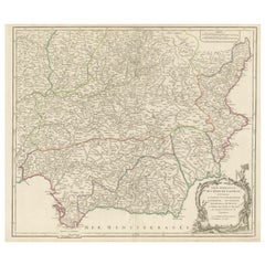
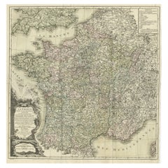
France Map 1757 – Southern Provinces by Isaak Tirion in Dutch Engraving
This original copperplate engraving published in 1757 by Isaak Tirion in Amsterdam presents a highly detailed and accurate map of southern France, titled *Nieuwe en Naaukeurige Kaart van het Zuidelyk Gedeelte van Frankryk*. Created during the Age of Enlightenment, this map reflects the Dutch tradition of precise geographical scholarship and decorative cartography.
Covering the entirety of southern France from the Atlantic coast at Bordeaux and Bayonne to the Mediterranean coastline including Marseille, Toulon, and the Gulf of Lyon, this map is rich in topographic and political detail. It shows the provincial divisions, major towns and cities, rivers, and mountainous regions with remarkable clarity. The coverage stretches from the Pyrenees and the Spanish border in the southwest through the Rhône Valley and into Dauphiné and Provence in the southeast.
The title cartouche in the lower left is printed in Dutch and includes a dedication to the geographical authorities of the era, while referencing the work of the French Academy. This indicates that the map was informed by the most reliable sources of its time, ensuring both scholarly precision and contemporary relevance.
Isaak Tirion (1705–1765) was a noted Dutch publisher and cartographer whose works were widely respected for their clarity and accuracy. His maps appeared in his landmark atlases such as the *Hedendaagsche Historie* and the *Nieuwe en Beknopte Hand-Atlas*. This map is a fine example of his style, emphasizing readability and elegant engraving.
Condition:
This antique map is in good condition for its age. There is are vertical folds as issued, with some light foxing, fold wear, and small edge tears outside the printed image. The paper retains good strength and the impression is crisp and clean with sharp detail.
Framing Tips:
For display, consider a simple but classic black or dark walnut frame with a warm off-white or cream-colored mat. Alternatively, a gold-accented frame can enhance the historical feel. This map makes a refined addition to any study, library, or travel-themed interior, especially for collectors of French or Dutch cartography.
- Maße:Höhe: 28 cm (11,03 in)Breite: 47,5 cm (18,71 in)Tiefe: 0,2 mm (0,01 in)
- Materialien und Methoden:Papier,Graviert
- Herkunftsort:
- Zeitalter:
- Herstellungsjahr:1757
- Zustand:Repariert: two tears have been restored with tape on the back side. Good condition for its age. There is are vertical folds as issued, with some light foxing, fold wear, and small edge tears outside the printed image. The impression is crisp and clean. Two repairs on the backside with tape.
- Anbieterstandort:Langweer, NL
- Referenznummer:Anbieter*in: BG-14031-11stDibs: LU3054345437872
Anbieterinformationen
5,0
Anerkannte Anbieter*innen
Diese renommierten Anbieter*innen sind führend in der Branche und repräsentieren die höchste Klasse in Sachen Qualität und Design.
Platin-Anbieter*in
Premium-Anbieter*innen mit einer Bewertung über 4,7 und 24 Stunden Reaktionszeit
Gründungsjahr 2009
1stDibs-Anbieter*in seit 2017
2.513 Verkäufe auf 1stDibs
Typische Antwortzeit: <1 Stunde
- VersandAngebot wird abgerufen …Versand von: Langweer, Niederlande
- Rückgabebedingungen
Einige Inhalte dieser Seite wurden automatisch übersetzt. Daher kann 1stDibs nicht die Richtigkeit der Übersetzungen garantieren. Englisch ist die Standardsprache dieser Website.
Authentizitätsgarantie
Im unwahrscheinlichen Fall eines Problems mit der Echtheit eines Objekts kontaktieren Sie uns bitte innerhalb von 1 Jahr für eine volle Rückerstattung. DetailsGeld-Zurück-Garantie
Wenn Ihr Objekt nicht der Beschreibung entspricht, beim Transport beschädigt wurde oder nicht ankommt, kontaktieren Sie uns bitte innerhalb von 7 Tagen für eine vollständige Rückerstattung. DetailsStornierung innerhalb von 24 Stunden
Sie können Ihren Kauf jederzeit innerhalb von 24 Stunden stornieren, ohne jegliche Gründe dafür angeben zu müssen.Geprüfte Anbieter*innen
Unsere Anbieter*innen unterliegen strengen Dienstleistungs- und Qualitätsstandards, wodurch wir die Seriosität unserer Angebote gewährleisten können.Preisgarantie
Wenn Sie feststellen, dass ein*e Anbieter*in dasselbe Objekt anderswo zu einem niedrigeren Preis anbietet, werden wir den Preis entsprechend anpassen.Zuverlässige weltweite Lieferung
Unsere erstklassigen Versandunternehmen bieten spezielle Versandoptionen weltweit, einschließlich individueller Lieferung.Mehr von diesem*dieser Anbieter*in
Alle anzeigenAntike Karte von Frankreich mit den englischen Kanälen, 1754
Antike Karte Frankreichs mit dem Titel "Eine genaue Karte von Frankreich, gezeichnet von den besten Behörden". Kleine, detaillierte Karte von Frankreich. Mit dekorativer Titelkartusc...
Kategorie
Antik, 18. Jahrhundert, Landkarten
Materialien
Papier

200 € Angebotspreis
20 % Rabatt
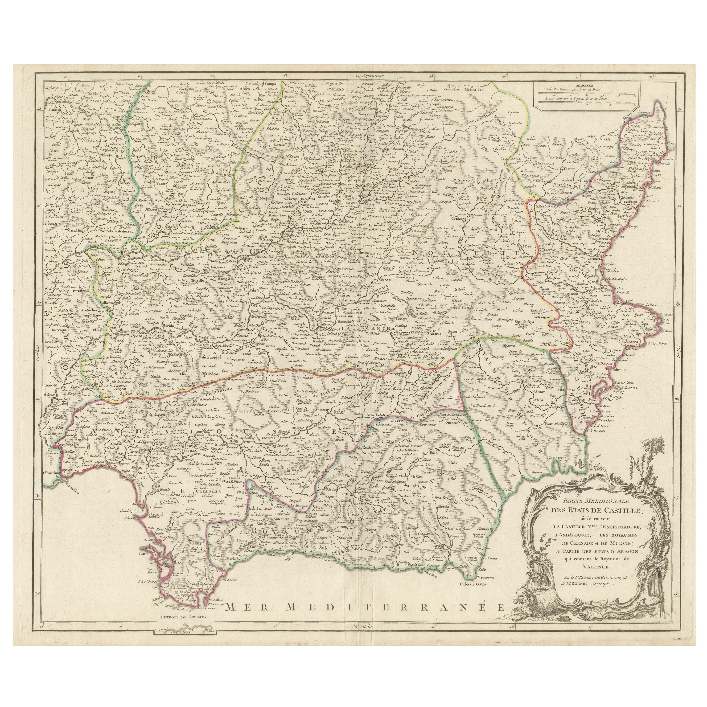
Detaillierte Gravur mit Schwerpunkten auf wichtigen Regionen Südspaniens und Castiles, 1752
Antike Karte mit dem Titel 'Partie Meridionale Des Etats de Castille (...)'. Dekorative und sehr detaillierte Karte des südlichen Teils von Kastilien, Spanien, mit einer dekorativen ...
Kategorie
Antik, Mitte des 18. Jahrhunderts, Landkarten
Materialien
Papier
528 € Angebotspreis
20 % Rabatt
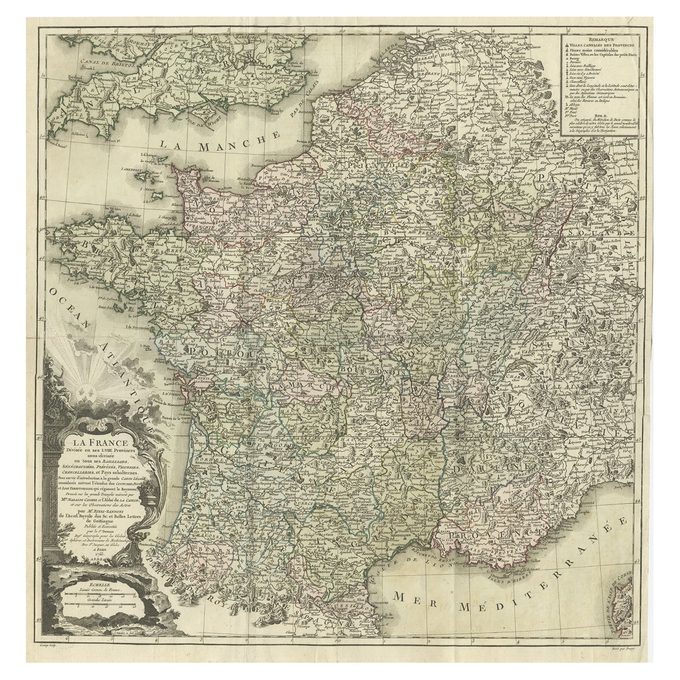
Antike Karte von Frankreich von Zannoni, 1765, antik
Antike Karte mit dem Titel 'La France divisée en ses LVIII Provinces (...)'. Schöne alte Karte von Frankreich. Diese Karte stammt aus dem "Atlas Historique de la France Ancienne et M...
Kategorie
Antik, 18. Jahrhundert, Landkarten
Materialien
Papier
416 € Angebotspreis
20 % Rabatt
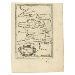
Detaillierte antike Miniaturkarte von Frankreich von Mallet, um 1683
Antike Karte mit dem Titel 'France en General'. BG-11796-55. Stammt aus Mallets "Description de l'Univers".
Künstler und Graveure: Alain Manneson Mallet (1630-1706) verbrachte den...
Kategorie
Antik, 17. Jahrhundert, Landkarten
Materialien
Papier
128 € Angebotspreis
20 % Rabatt
Antike Karte des antiken Frankreichs von Zannoni, 1765
Antike Karte Frankreich mit dem Titel 'Galliae Veteris (..)'. Schöne alte Karte von Frankreich. Diese Karte stammt aus dem "Atlas Historique de la France Ancienne et Moderne" von M. ...
Kategorie
Antik, 18. Jahrhundert, Landkarten
Materialien
Papier

256 € Angebotspreis
20 % Rabatt
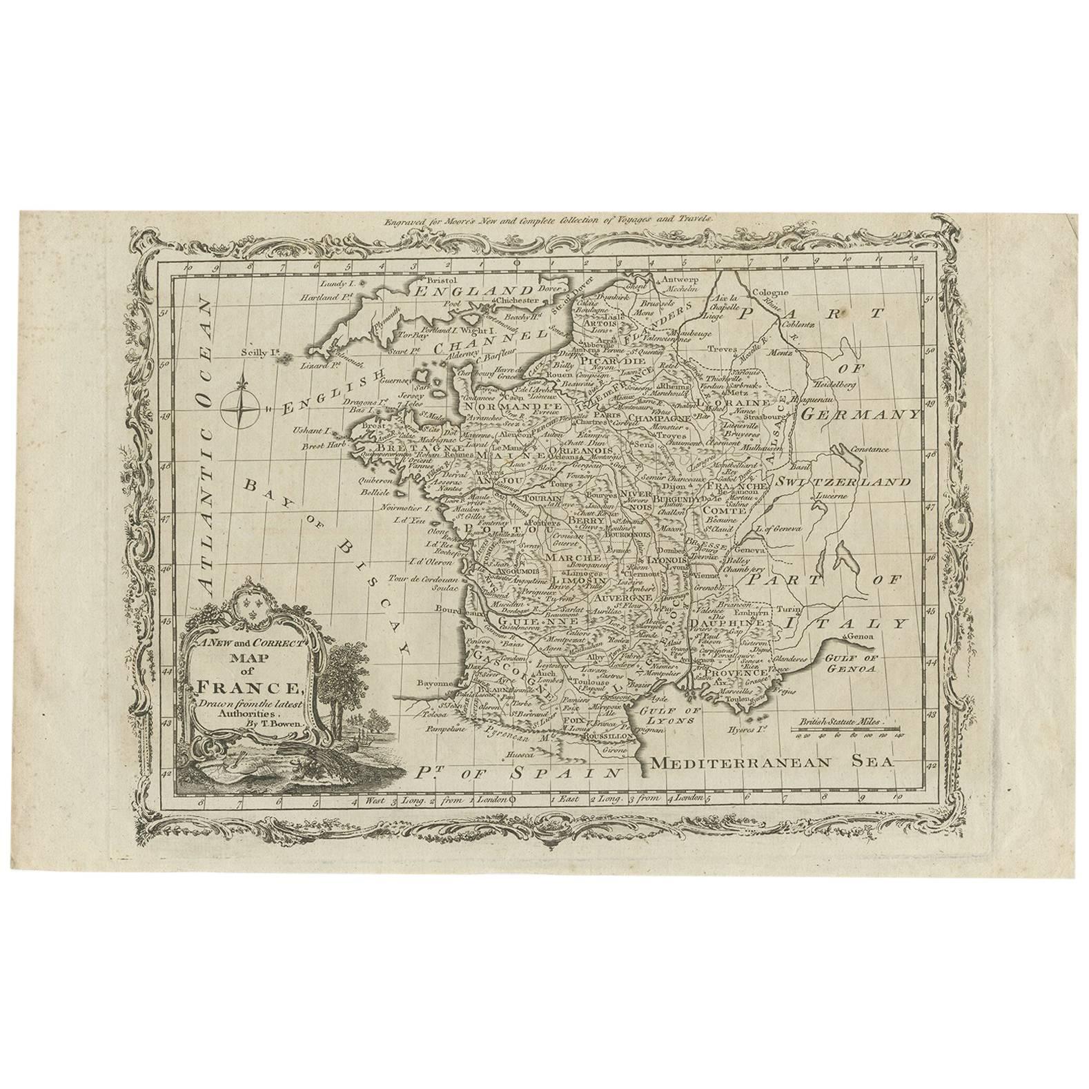
Antike Karte von Frankreich von T. Bowen, 1785
Dekorative antike Karte von Frankreich mit dem Titel 'Eine neue und genaue Karte von Frankreich, gezeichnet nach den neuesten Erkenntnissen von T. Bowen'. Gestochen für Moore's neue ...
Kategorie
Antik, Spätes 18. Jahrhundert, Landkarten
Materialien
Papier
128 € Angebotspreis
20 % Rabatt
Das könnte Ihnen auch gefallen
Li Governi di Borgogna – Karte aus der Antike – 1777
Li Governi di Borgogna ist eine Original-Radierung in Schwarz-Weiß auf Papier, gedruckt von Antonio Zatta in Venedig, 1777.
Originaltitel: Li Governi di Borgogna della Franca Contea...
Kategorie
1770er, Moderne, Landschaftsdrucke
Materialien
Radierung

Map Holy Land La Terre Sainte gravierte van Loon veröffentlicht N de Fer 1703 Französisch, Heiliges Land
La Terre Sainte, Das Heilige Land, Tiree Des Memoires De M.De.La Rue. Par N. de Fer. Geographe de Sa Majeste Catoliq et de Monseigneur le Dauphin. Avec Privil du Roi 1703
Detailli...
Kategorie
Antik, Anfang 1700, Französisch, Louis XIV., Landkarten
Materialien
Papier

1751 Karte von Spanien, Castilla Robert De Vaugondy, 1. Auflage, Ric.a001
Groß Spanien Kastilien Robert De Vaugondy
1751 1. Auflage
-Farbig- Ric.a001
Gilles Robert de Vaugondy stammt aus einer Familie von Kartographen, ist ein Nachkomme des berühmten...
Kategorie
Antik, 18. Jahrhundert, Unbekannt, Landkarten
Materialien
Papier

1771 Bonne Karte von Poitou, Touraine und Anjou, Frankreich, Ric.a015
1771 Bonne-Karte von Poitou,
Touraine und Anjou, Frankreich
Ric.a015
1771 Bonne-Karte von Potiou, Touraine und Anjou mit dem Titel "Carte des Gouvernements D'Anjou et du Sau...
Kategorie
Antik, 17. Jahrhundert, Unbekannt, Landkarten
Materialien
Papier

1714 Henri Chatelain „“Nouvelle Carte Des Etatas Du Grand.Duc De Mos Moscovie Eur
Eine Karte von Henri Chatelain aus dem Jahr 1714 mit dem Titel
"Nouvelle Carte Des Etatas Du Grand Duc De Moscovie En Europe,"
Ricb001
Henri Abraham Chatelain (1684-1743) war e...
Kategorie
Antik, Frühes 18. Jahrhundert, Niederländisch, Landkarten
Materialien
Papier

Kartenkarte Frankreichs – Radierung – 1820
Karte von Frankreich ist eine Original-Radierung von einem unbekannten Künstler des 19. Jahrhunderts im Jahr 1820 realisiert.
Sehr guter Zustand auf zwei weißen Blättern, die in der...
Kategorie
1820er, Moderne, Figurative Drucke
Materialien
Radierung
