Objekte ähnlich wie Map of Ardèche France with Annonay and Vineyards by Vuillemin, 19th c


Möchten Sie mehr Bilder oder Videos?
Zusätzliche Bilder oder Videos von dem*der Anbieter*in anfordern
1 von 11
Map of Ardèche France with Annonay and Vineyards by Vuillemin, 19th c
120 €Einschließlich MwSt.
Angaben zum Objekt
Map of Ardèche France with Annonay and Vineyards by Vuillemin, 19th c
This beautifully engraved 19th-century map of Ardèche, a department in southeastern France, comes from Alexandre Vuillemin’s *Nouvel Atlas Illustré*, published in Paris by Migeon. The map offers a detailed and artistic representation of the region, enhanced by vignettes, coats of arms, and historical references that highlight Ardèche’s cultural and natural richness.
The map presents the department’s full geographical scope with towns, rivers, and road networks, bordered by hand-applied yellow watercolor. Key locations such as Annonay, Privas, and Aubenas are clearly marked. The engraving also depicts the rugged terrain for which the Ardèche is well known, including the mountainous Massif Central and deep river gorges. In the upper left is a vignette of the town of Annonay, famous as the birthplace of the Montgolfier brothers, pioneers of balloon flight. Below that is a depiction of the natural stone arch of the Pont d’Arc, one of the most iconic landmarks in the region.
In the lower right corner, a striking scene depicts Joseph Marie Jacquard presenting his invention of the Jacquard loom, symbolizing Ardèche’s historical contributions to the textile industry. Jacquard’s automated loom was a key innovation in the development of modern weaving.
Ardèche is also a celebrated wine-producing region, especially in the southern part of the department near the Rhône Valley. The area is known for its rustic, characterful wines, including red blends made from Grenache, Syrah, and Merlot, as well as fresh white wines from Viognier and Chardonnay grapes. These wines are often labeled under the Côtes du Vivarais and Coteaux de l’Ardèche designations. The region’s climate and diverse terroirs make it an increasingly respected area within the Rhône wine landscape.
Alexandre Vuillemin, a skilled 19th-century French cartographer, was renowned for blending geography with artistic and cultural elements in his maps. His works were both decorative and informative, aimed at a growing educated public. The publisher, Migeon, was known for high-quality atlases that brought historical and geographic knowledge to a broad audience.
Condition summary:
Excellent impression with mild toning to the edges and a few small, scattered foxing marks. The hand-coloring remains vivid and the engraving is sharp and detailed.
Framing tips:
A classic dark wood or olive-toned frame will highlight the natural character of the Ardèche region. A warm off-white or light tan mat works well to emphasize the yellow hand-coloring. Use UV-protective glass for preservation.
- Maße:Höhe: 26,1 cm (10,28 in)Breite: 32,5 cm (12,8 in)Tiefe: 0,2 mm (0,01 in)
- Materialien und Methoden:Papier,Graviert
- Herkunftsort:
- Zeitalter:
- Herstellungsjahr:circa 1850
- Zustand:Excellent impression with mild toning to the edges and a few small, scattered foxing marks. The hand-coloring remains vivid and the engraving is sharp and detailed.
- Anbieterstandort:Langweer, NL
- Referenznummer:Anbieter*in: BG-13331-61stDibs: LU3054345359162
Anbieterinformationen
5,0
Anerkannte Anbieter*innen
Diese renommierten Anbieter*innen sind führend in der Branche und repräsentieren die höchste Klasse in Sachen Qualität und Design.
Platin-Anbieter*in
Premium-Anbieter*innen mit einer Bewertung über 4,7 und 24 Stunden Reaktionszeit
Gründungsjahr 2009
1stDibs-Anbieter*in seit 2017
2.531 Verkäufe auf 1stDibs
Typische Antwortzeit: <1 Stunde
- VersandAngebot wird abgerufen …Versand von: Langweer, Niederlande
- Rückgabebedingungen
Einige Inhalte dieser Seite wurden automatisch übersetzt. Daher kann 1stDibs nicht die Richtigkeit der Übersetzungen garantieren. Englisch ist die Standardsprache dieser Website.
Authentizitätsgarantie
Im unwahrscheinlichen Fall eines Problems mit der Echtheit eines Objekts kontaktieren Sie uns bitte innerhalb von 1 Jahr für eine volle Rückerstattung. DetailsGeld-Zurück-Garantie
Wenn Ihr Objekt nicht der Beschreibung entspricht, beim Transport beschädigt wurde oder nicht ankommt, kontaktieren Sie uns bitte innerhalb von 7 Tagen für eine vollständige Rückerstattung. DetailsStornierung innerhalb von 24 Stunden
Sie können Ihren Kauf jederzeit innerhalb von 24 Stunden stornieren, ohne jegliche Gründe dafür angeben zu müssen.Geprüfte Anbieter*innen
Unsere Anbieter*innen unterliegen strengen Dienstleistungs- und Qualitätsstandards, wodurch wir die Seriosität unserer Angebote gewährleisten können.Preisgarantie
Wenn Sie feststellen, dass ein*e Anbieter*in dasselbe Objekt anderswo zu einem niedrigeren Preis anbietet, werden wir den Preis entsprechend anpassen.Zuverlässige weltweite Lieferung
Unsere erstklassigen Versandunternehmen bieten spezielle Versandoptionen weltweit, einschließlich individueller Lieferung.Mehr von diesem*dieser Anbieter*in
Alle anzeigenMap of Ariège France with Foix and Pyrenees Landscape by Vuillemin, 19th c
Map of Ariège France with Foix and Pyrenees Landscape by Vuillemin, 19th c
Description:
This beautifully detailed 19th-century map of the Ariège department in southwestern France wa...
Kategorie
Antik, Mittleres 19. Jahrhundert, Französisch, Landkarten
Materialien
Papier

Map of Aude France with Carcassonne and Languedoc Vineyards, 19th Century
Map of Aude France with Carcassonne and Languedoc Vineyards, 19th Century
Description:
This elegant 19th-century map of Aude, a department in southern France along the Mediterranean...
Kategorie
Antik, Mittleres 19. Jahrhundert, Französisch, Landkarten
Materialien
Papier

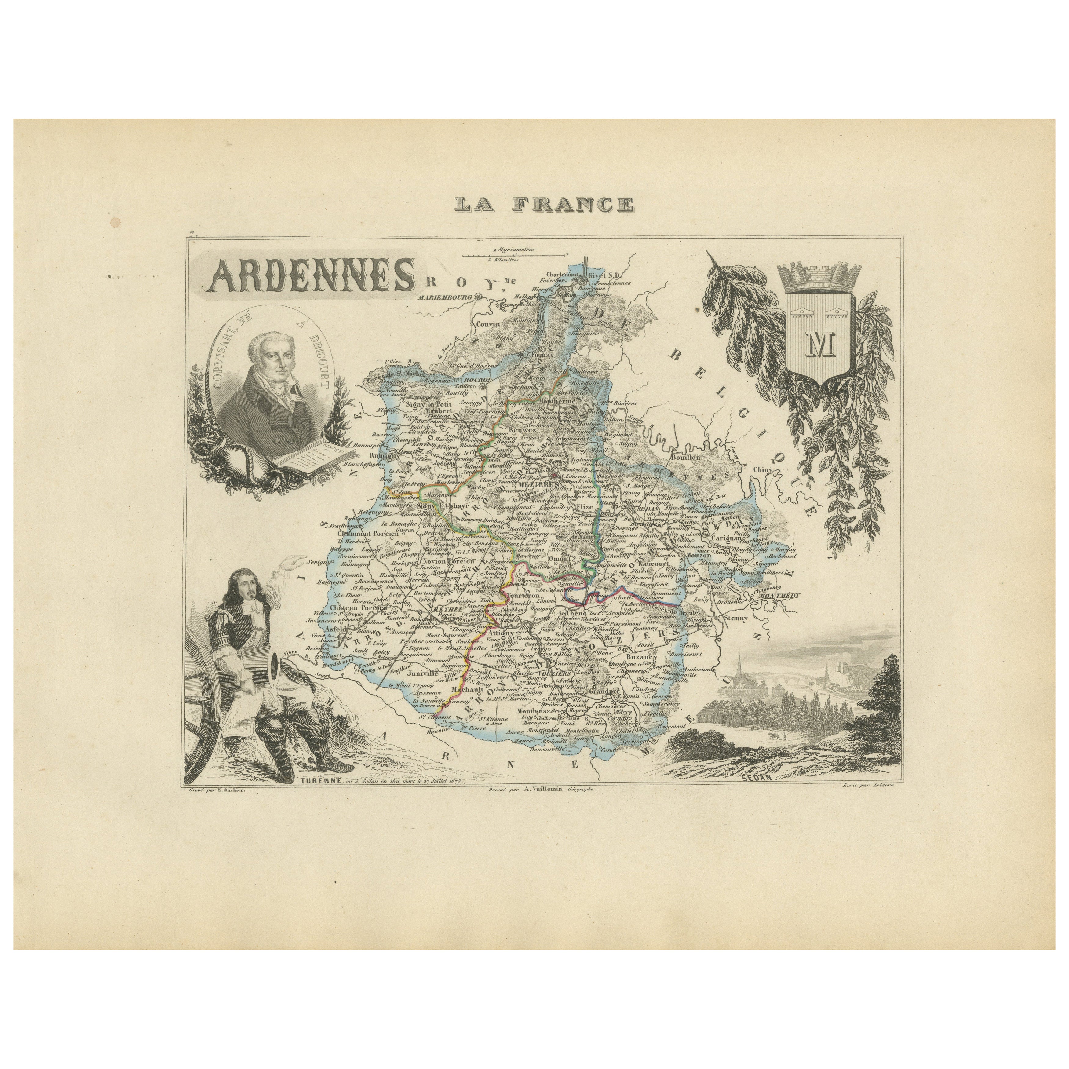
Map of Ardennes France with Sedan and Military History by Vuillemin, c.1850
Map of Ardennes France with Sedan and Military History by Vuillemin, 19th c
Description:
This detailed and decorative 19th-century map of the Ardennes department in northeastern Fra...
Kategorie
Antik, Mittleres 19. Jahrhundert, Französisch, Landkarten
Materialien
Papier
Map of Aisne France with Soissons and Champagne Vineyards by Vuillemin, 19th c
Map of Aisne France with Soissons and Champagne Vineyards by Vuillemin, 19th c
Description:
This richly detailed 19th-century engraved and hand-colored map of the department of Aisn...
Kategorie
Antik, Mittleres 19. Jahrhundert, Französisch, Landkarten
Materialien
Papier

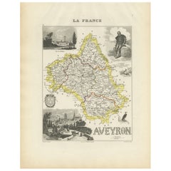
Map of Aveyron France with Rodez, Millau and Wine Routes, 19th Century
Map of Aveyron France with Rodez, Millau and Wine Routes, 19th Century
Description:
This detailed and decorative 19th-century map of Aveyron, a department in southern France, was dr...
Kategorie
Antik, Mittleres 19. Jahrhundert, Französisch, Landkarten
Materialien
Papier
Map of Allier France with Saint-Pourçain Wine Region by Vuillemin, 19th c
Map of Allier France with Saint-Pourçain Wine Region by Vuillemin, 19th c
This decorative 19th-century map of Allier, a central department of France, comes from the celebrated Nouve...
Kategorie
Antik, Mittleres 19. Jahrhundert, Französisch, Landkarten
Materialien
Papier

Das könnte Ihnen auch gefallen
Aude, Frankreich. Antike Karte einer französischen Abteilung, 1856
Von Victor Levasseur
dept. de L' Aude", Stahlstich mit Originalumriss von Hand koloriert, 1856, aus Levasseurs "Atlas National Illustre".
Diese Region Frankreichs ist berühmt für ihre große Vielfalt an...
Kategorie
19. Jahrhundert, Naturalismus, Landschaftsdrucke
Materialien
Gravur

Var, Frankreich. Antike Karte einer französischen Abteilung, 1856
Von Victor Levasseur
dept. du Var", Stahlstich mit handkolorierten Originalumrissen, 1856, aus dem Atlas National Illustre von Levasseur.
Var liegt im Herzen der Côte d'Azur und umfasst unter anderem d...
Kategorie
19. Jahrhundert, Naturalismus, Landschaftsdrucke
Materialien
Gravur

Lozere, Frankreich. Antike Karte einer französischen Abteilung, 1856
Von Victor Levasseur
dept. de La Lozere", Stahlstich mit originaler Handkolorierung der Umrisse, 1856, aus dem "Atlas National Illustre" von Levasseur.
Dieser abgelegene, gebirgige Teil des Languedoc i...
Kategorie
19. Jahrhundert, Naturalismus, Landschaftsdrucke
Materialien
Gravur

L'Isere, Frankreich. Antike Karte der französischen Abteilung, 1856
Von Victor Levasseur
dept. de L'Isere", Stahlstich mit Originalumriss von Hand koloriert, 1856, aus Levasseurs "Atlas National Illustre".
Dieses Gebiet ist bekannt für die Herstellung von Bleu du Verco...
Kategorie
19. Jahrhundert, Naturalismus, Landschaftsdrucke
Materialien
Gravur

Beinahe Frankreich. Antike Karte einer französischen Abteilung, 1856
Von Victor Levasseur
dept. de L'Aube", Stahlstich mit originaler Handkolorierung der Umrisse, 1856, aus dem "Atlas National Illustre" von Levasseur.
Diese Region Frankreichs ist bekannt für die Herstel...
Kategorie
19. Jahrhundert, Naturalismus, Landschaftsdrucke
Materialien
Gravur

Der L'Herault, Frankreich. Antike Karte einer französischen Abteilung, 1856
Von Victor Levasseur
dept. de Saone et Loire", Stahlstich mit originaler Handkolorierung der Umrisse, 1856, aus: Atlas National Illustre von Levasseur.
Dieses Gebiet beherbergt eine große Vielfalt an W...
Kategorie
19. Jahrhundert, Naturalismus, Landschaftsdrucke
Materialien
Gravur
