Objekte ähnlich wie Map of Brittany and Western France by Gerard Valk, circa 1690


Möchten Sie mehr Bilder oder Videos?
Zusätzliche Bilder oder Videos von dem*der Anbieter*in anfordern
1 von 10
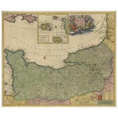
Map of Brittany and Western France by Gerard Valk, circa 1690
770 €Einschließlich MwSt.
Angaben zum Objekt
Map of Brittany and Western France by Gerard Valk, circa 1700
This finely detailed antique map, titled *Praefectura Ducatus Britanniae, Quae Superior et Inferior*, was created around 1700 by the Dutch cartographer Gerard Valk. It presents an expansive view of the Duchy of Brittany (Bretagne), historically one of the most culturally distinct and politically significant regions of France. The map reaches eastward to include major cities such as Nantes, Rennes, and Saint-Malo, showing the full extent of both Upper and Lower Brittany.
Gerard Valk (1652–1726) was a prominent mapmaker and globe manufacturer based in Amsterdam. He collaborated with Pieter Schenk and other leading Dutch engravers to publish a number of influential atlases and wall maps. Valk’s maps are known for their clarity, strong engraving technique, and elegant color schemes, and they remain highly desirable among collectors of early cartography.
This particular map displays the western peninsula of France in striking detail, with its rugged coastlines along the Atlantic Ocean, islands such as Belle-Île, and extensive inland geography. Administrative divisions are outlined in yellow and pink hand-coloring, clearly marking the boundaries of ecclesiastical and civil jurisdictions. Towns, rivers, forests, and roadways are all carefully engraved, creating a layered and accurate representation of the region as it stood at the dawn of the 18th century.
The map includes references to bishoprics and archbishoprics, underlining the strong ecclesiastical structure of the region. Its Latin title and classical labeling reflect the scholarly nature of maps in this period, serving both practical and educational purposes.
As a historical object, this map captures a time just before the unification and modernization of the French administrative system. Brittany still retained elements of its medieval autonomy and cultural identity, especially through its language, customs, and religious institutions.
Condition summary:
Good condition with original hand-coloring. Centerfold as issued. Slight toning at edges, but overall crisp and well-preserved. Strong paper.
Framing tips:
Best suited for a gold or dark wood frame with a warm off-white or ivory mat. This will enhance the classical feel and draw out the color contrast. Use museum glass to preserve the detail and reduce glare.
- Maße:Höhe: 51,7 cm (20,36 in)Breite: 60,5 cm (23,82 in)Tiefe: 0,2 mm (0,01 in)
- Materialien und Methoden:Papier,Graviert
- Herkunftsort:
- Zeitalter:Spätes 17. Jahrhundert
- Herstellungsjahr:circa 1690
- Zustand:Good condition with original hand-coloring. Centerfold as issued. Slight toning at edges, but overall crisp and well-preserved. Strong paper.
- Anbieterstandort:Langweer, NL
- Referenznummer:Anbieter*in: BG-13732-61stDibs: LU3054345364142
Anbieterinformationen
5,0
Anerkannte Anbieter*innen
Diese renommierten Anbieter*innen sind führend in der Branche und repräsentieren die höchste Klasse in Sachen Qualität und Design.
Platin-Anbieter*in
Premium-Anbieter*innen mit einer Bewertung über 4,7 und 24 Stunden Reaktionszeit
Gründungsjahr 2009
1stDibs-Anbieter*in seit 2017
2.587 Verkäufe auf 1stDibs
Typische Antwortzeit: <1 Stunde
- VersandAngebot wird abgerufen …Versand von: Langweer, Niederlande
- Rückgabebedingungen
Einige Inhalte dieser Seite wurden automatisch übersetzt. Daher kann 1stDibs nicht die Richtigkeit der Übersetzungen garantieren. Englisch ist die Standardsprache dieser Website.
Authentizitätsgarantie
Im unwahrscheinlichen Fall eines Problems mit der Echtheit eines Objekts kontaktieren Sie uns bitte innerhalb von 1 Jahr für eine volle Rückerstattung. DetailsGeld-Zurück-Garantie
Wenn Ihr Objekt nicht der Beschreibung entspricht, beim Transport beschädigt wurde oder nicht ankommt, kontaktieren Sie uns bitte innerhalb von 7 Tagen für eine vollständige Rückerstattung. DetailsStornierung innerhalb von 24 Stunden
Sie können Ihren Kauf jederzeit innerhalb von 24 Stunden stornieren, ohne jegliche Gründe dafür angeben zu müssen.Geprüfte Anbieter*innen
Unsere Anbieter*innen unterliegen strengen Dienstleistungs- und Qualitätsstandards, wodurch wir die Seriosität unserer Angebote gewährleisten können.Preisgarantie
Wenn Sie feststellen, dass ein*e Anbieter*in dasselbe Objekt anderswo zu einem niedrigeren Preis anbietet, werden wir den Preis entsprechend anpassen.Zuverlässige weltweite Lieferung
Unsere erstklassigen Versandunternehmen bieten spezielle Versandoptionen weltweit, einschließlich individueller Lieferung.Mehr von diesem*dieser Anbieter*in
Alle anzeigenSeltene handkolorierte Karte von Lorraine und Barrois, Frankreich, von Frederik De Wit, um 1688
Titel: Seltene handkolorierte Karte von Lorraine und Barrois von Frederik De Wit um 1688
Beschreibung: Diese bemerkenswerte Karte aus dem 17. Jahrhundert mit dem Titel "Generalis Lo...
Kategorie
Antik, 1680er, Landkarten
Materialien
Papier

Schöne Karte von Paris und der Isle de France aus dem 17. Jahrhundert von Templeux, um 1650
Karte der Isle de France von D. de Templeux, ca. 1650, handkoloriert und dekorativ
Diese detailreiche antike Karte mit dem Titel *Le Gouvernement de L'Isle de France* wurde von Dani...
Kategorie
Antik, 1650er, Landkarten
Materialien
Papier

Originale Normandiekarte der Normandie von Frederick de Wit, 1705, mit Einlage von Kanalinseln
Normandiekarte von Frederick de Wit, 1705, mit Inszenierung der Kanalinseln
Beschreibung:
Diese wunderschön gestochene und handkolorierte Karte mit dem Titel Duché et Gouvernement G...
Kategorie
Antik, Anfang 1700, Landkarten
Materialien
Papier
Antike Karte von Frankreich von Tirion, um 1740
Antike Karte mit dem Titel 'Nieuwe Kaart van Frankryk'. - Attraktive detaillierte Karte von Frankreich. Titel in Blockkartusche mit einfacher Kompassrose. Quelle unbekannt, muss noch...
Kategorie
Antik, 18. Jahrhundert, Landkarten
Materialien
Papier
360 € Angebotspreis
20 % Rabatt
Atemberaubende handkolorierte Karte der Languedoc in Frankreich von Frederik De Wit, um 1688
Titel: Wunderschöne handkolorierte Karte des Languedoc von Frederik De Wit um 1688
Beschreibung: Diese elegante Karte "Gouvernement General de Languedoc" aus dem 17. Jahrhundert zei...
Kategorie
Antik, 1680er, Landkarten
Materialien
Papier
Antike Karte Frankreichs von Mortier, um 1730
Antike Karte mit dem Titel 'Galliae Antiquae Tabula'. Original antike Karte von Frankreich in der Antike. Herausgegeben von P. Mortier, um 1730.
Kategorie
Antik, Mitte des 18. Jahrhunderts, Landkarten
Materialien
Papier

900 € Angebotspreis
25 % Rabatt
Das könnte Ihnen auch gefallen
1640 Joan Bleau Karte mit dem Titel „Diocecese de rheims et le pais de rethel“, Eic.a011
1640 Joan Bleau Karte mit dem Titel
"Diocecese de rheims et le pais de rethel,"
Ric.a011
OAN BLAEU
Diocecese de Rheims, et le pais de Rethel.
Handkolorierter Kupfersti...
Kategorie
Antik, 17. Jahrhundert, Niederländisch, Landkarten
Materialien
Papier

1752 Vaugoundy-Karte von Flandern: Belgien, Frankreich und die Niederlande, Ric.a002
Große Vaugoundy-Karte von Flandern:
Belgien, Frankreich und die Niederlande
Farbig -1752
Ric.a002
Beschreibung: Dies ist eine 1752 Didier Robert de Vaugondy Karte von Flander...
Kategorie
Antik, 17. Jahrhundert, Unbekannt, Landkarten
Materialien
Papier

Französische Region der Normandie: Eine handkolorierte Karte aus dem 17. Jahrhundert von Sanson und Jaillot
Von Nicholas Sanson d'Abbeville
Diese große handkolorierte Karte mit dem Titel "Le Duché et Gouvernement de Normandie divisée en Haute et Basse Normandie en divers Pays; et par evêchez, avec le Gouvernement General...
Kategorie
1690er, Landschaftsdrucke
Materialien
Gravur

1771 Bonne Karte von Poitou, Touraine und Anjou, Frankreich, Ric.a015
1771 Bonne-Karte von Poitou,
Touraine und Anjou, Frankreich
Ric.a015
1771 Bonne-Karte von Potiou, Touraine und Anjou mit dem Titel "Carte des Gouvernements D'Anjou et du Sau...
Kategorie
Antik, 17. Jahrhundert, Unbekannt, Landkarten
Materialien
Papier

1635 Willem Blaeu Karte von Nordfrankreich „Comitatvs Bellovacvm“ Ric.a08
1635 Willem Blaeu Karte von Nordfrankreich, betitelt.
"Comitatvs Bellovacvm Vernacule Beavvais,"
Farbig
Ric.a008
"COMITATVS BELLOVACVM..." Amsterdam: Willem J. Blaeu, um 1635...
Kategorie
Antik, 17. Jahrhundert, Unbekannt, Landkarten
Materialien
Papier

Das Loire-Tal in Frankreich: Eine handkolorierte Karte aus dem 17. Jahrhundert von Sanson und Jaillot
Von Nicholas Sanson d'Abbeville
Diese große handkolorierte Kupferstichkarte aus dem 17. Jahrhundert mit dem Titel "Gouvernement D'Orleans et la Generalite divisee en ses Elections Par le Sanson" wurde ursprünglich ...
Kategorie
1690er, Landschaftsdrucke
Materialien
Gravur
