Objekte ähnlich wie Map of Côte-d'Or France with Dijon and Burgundy Wine Region, 19th Century


Möchten Sie mehr Bilder oder Videos?
Zusätzliche Bilder oder Videos von dem*der Anbieter*in anfordern
1 von 10
Map of Côte-d'Or France with Dijon and Burgundy Wine Region, 19th Century
140 €Einschließlich MwSt.
Angaben zum Objekt
Map of Côte-d'Or France with Dijon and Burgundy Wine Region, 19th Century
Description:
This beautifully engraved 19th-century map of Côte-d'Or, located in the historic region of Burgundy, was drawn by Alexandre Vuillemin and published by Migeon in Paris as part of the *Nouvel Atlas Illustré*. Meticulously detailed and adorned with elegant vignettes, the map presents one of France’s most prestigious wine regions with geographic clarity and cultural reverence.
The map is bordered in soft pink watercolor and includes all major roads, rivers, and towns. Dijon, the department’s capital and a center of culture and gastronomy, is prominently marked, as are Beaune, Nuits-Saint-Georges, and other key communes of the Côte d’Or vineyard belt. The topography emphasizes the region’s east-facing slopes that form the heart of the wine-producing Côte de Nuits and Côte de Beaune.
In the lower left is an engraving of the city of Dijon, framed by its Gothic spires and medieval architecture. In the upper right is a portrait of a notable local figure, finely framed with ornamental detailing. The departmental coat of arms appears in the upper left, flanked by grapevines and acanthus leaves, alluding to the wine heritage of the region.
Côte-d'Or is home to some of the world’s most renowned vineyards, producing exceptional Pinot Noir and Chardonnay wines. The Côte de Nuits is celebrated for its powerful, age-worthy reds, including grand crus like Romanée-Conti and Clos de Vougeot. The Côte de Beaune is known for both outstanding reds and whites, with names such as Meursault, Puligny-Montrachet, and Corton-Charlemagne. The region’s complex terroir, centuries-old wine tradition, and strict appellation controls make it a benchmark for fine wine globally.
This map is not only a tribute to the geography of the region but also a beautiful celebration of its vinicultural and architectural achievements. It is ideal for collectors of antique maps, wine history, or French decorative prints.
Condition summary:
Very good condition with minor foxing and some light toning to the outer margins. The hand-coloring remains vibrant, and the engraving is clean and crisp.
Framing tips:
A dark mahogany or black frame pairs elegantly with the refined engraving style and pink border. A warm cream or light grey mat complements the map's historical aesthetic. Use museum-grade glass to protect the artwork and enhance visual clarity.
- Maße:Höhe: 32,5 cm (12,8 in)Breite: 26,1 cm (10,28 in)Tiefe: 0,2 mm (0,01 in)
- Materialien und Methoden:Papier,Graviert
- Herkunftsort:
- Zeitalter:
- Herstellungsjahr:circa 1850
- Zustand:Very good condition with minor foxing and some light toning to the outer margins. The hand-coloring remains vibrant, and the engraving is clean and crisp.
- Anbieterstandort:Langweer, NL
- Referenznummer:Anbieter*in: BG-13331-201stDibs: LU3054345363642
Anbieterinformationen
5,0
Anerkannte Anbieter*innen
Diese renommierten Anbieter*innen sind führend in der Branche und repräsentieren die höchste Klasse in Sachen Qualität und Design.
Platin-Anbieter*in
Premium-Anbieter*innen mit einer Bewertung über 4,7 und 24 Stunden Reaktionszeit
Gründungsjahr 2009
1stDibs-Anbieter*in seit 2017
2.531 Verkäufe auf 1stDibs
Typische Antwortzeit: <1 Stunde
- VersandAngebot wird abgerufen …Versand von: Langweer, Niederlande
- Rückgabebedingungen
Einige Inhalte dieser Seite wurden automatisch übersetzt. Daher kann 1stDibs nicht die Richtigkeit der Übersetzungen garantieren. Englisch ist die Standardsprache dieser Website.
Authentizitätsgarantie
Im unwahrscheinlichen Fall eines Problems mit der Echtheit eines Objekts kontaktieren Sie uns bitte innerhalb von 1 Jahr für eine volle Rückerstattung. DetailsGeld-Zurück-Garantie
Wenn Ihr Objekt nicht der Beschreibung entspricht, beim Transport beschädigt wurde oder nicht ankommt, kontaktieren Sie uns bitte innerhalb von 7 Tagen für eine vollständige Rückerstattung. DetailsStornierung innerhalb von 24 Stunden
Sie können Ihren Kauf jederzeit innerhalb von 24 Stunden stornieren, ohne jegliche Gründe dafür angeben zu müssen.Geprüfte Anbieter*innen
Unsere Anbieter*innen unterliegen strengen Dienstleistungs- und Qualitätsstandards, wodurch wir die Seriosität unserer Angebote gewährleisten können.Preisgarantie
Wenn Sie feststellen, dass ein*e Anbieter*in dasselbe Objekt anderswo zu einem niedrigeren Preis anbietet, werden wir den Preis entsprechend anpassen.Zuverlässige weltweite Lieferung
Unsere erstklassigen Versandunternehmen bieten spezielle Versandoptionen weltweit, einschließlich individueller Lieferung.Mehr von diesem*dieser Anbieter*in
Alle anzeigenMap of Allier France with Saint-Pourçain Wine Region by Vuillemin, 19th c
Map of Allier France with Saint-Pourçain Wine Region by Vuillemin, 19th c
This decorative 19th-century map of Allier, a central department of France, comes from the celebrated Nouve...
Kategorie
Antik, Mittleres 19. Jahrhundert, Französisch, Landkarten
Materialien
Papier

Map of Côtes-du-Nord France with Saint-Brieuc and Brittany Coastline, c.1850
Map of Côtes-du-Nord France with Saint-Brieuc and Brittany Coastline, 19th c
Description:
This elegant 19th-century map of Côtes-du-Nord, the historic name for what is now known as ...
Kategorie
Antik, Mittleres 19. Jahrhundert, Französisch, Landkarten
Materialien
Papier

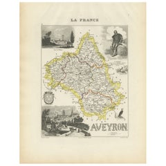
Map of Aveyron France with Rodez, Millau and Wine Routes, 19th Century
Map of Aveyron France with Rodez, Millau and Wine Routes, 19th Century
Description:
This detailed and decorative 19th-century map of Aveyron, a department in southern France, was dr...
Kategorie
Antik, Mittleres 19. Jahrhundert, Französisch, Landkarten
Materialien
Papier
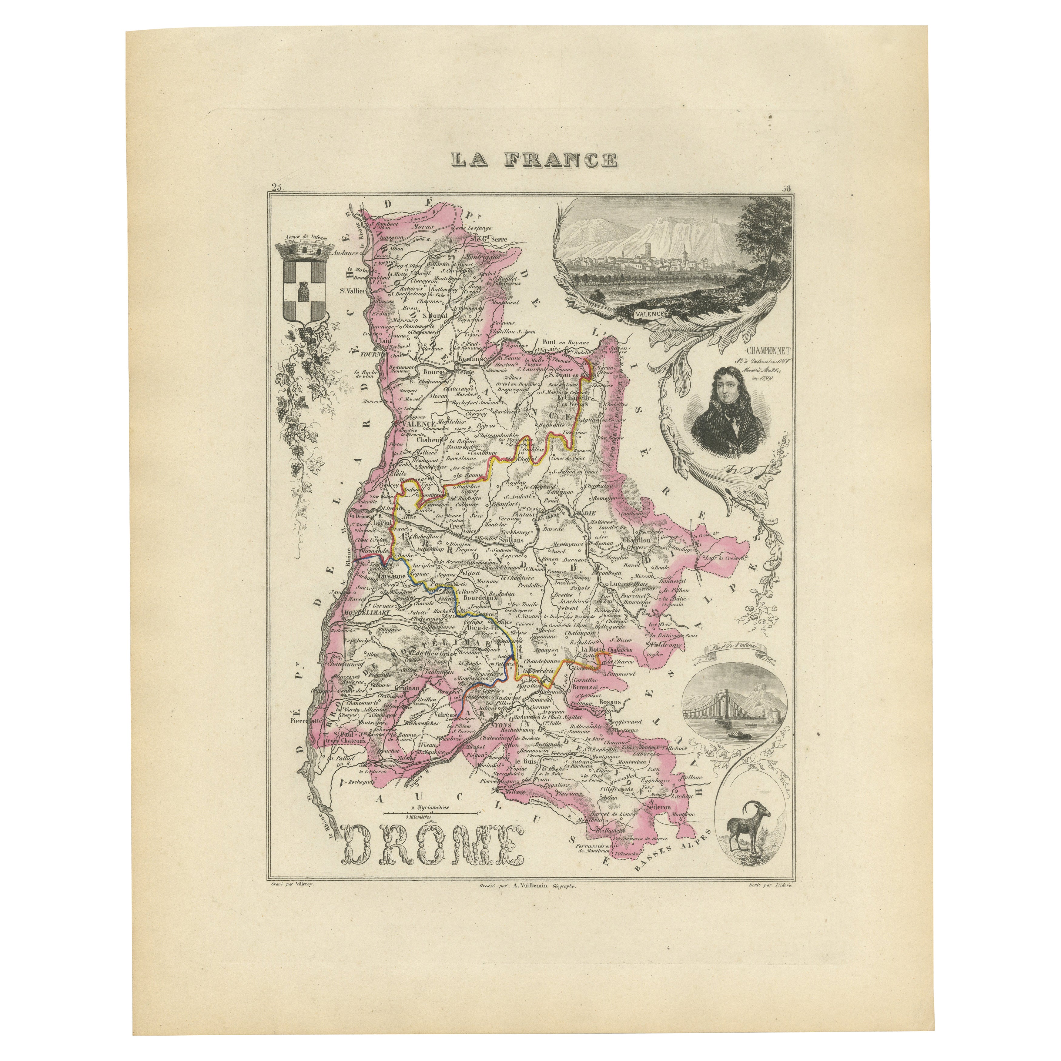
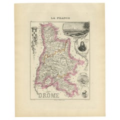
Map of Drôme France with Valence and Rhône Valley Wine Region, 19th Century
Map of Drôme France with Valence and Rhône Valley Wine Region, 19th Century
Description:
This beautifully engraved 19th-century map of the Drôme department in southeastern France wa...
Kategorie
Antik, Mittleres 19. Jahrhundert, Französisch, Landkarten
Materialien
Papier
Map of Gard France with Pont du Gard and Wine Regions by Vuillemin, 19th c
Title: Map of Gard France with Pont du Gard and Wine Regions by Vuillemin, 19th c
Description:
This finely engraved 19th-century map of the department of Gard in southern France was...
Kategorie
Antik, Mittleres 19. Jahrhundert, Französisch, Landkarten
Materialien
Papier

Map of Aude France with Carcassonne and Languedoc Vineyards, 19th Century
Map of Aude France with Carcassonne and Languedoc Vineyards, 19th Century
Description:
This elegant 19th-century map of Aude, a department in southern France along the Mediterranean...
Kategorie
Antik, Mittleres 19. Jahrhundert, Französisch, Landkarten
Materialien
Papier

Das könnte Ihnen auch gefallen
Große Karte von Frankreich aus dem 19.
Große Karte von Frankreich aus dem 19. Jahrhundert.
Bemerkenswerter Zustand, mit einer angenehmen altersbedingten Patina.
Kürzlich gerahmt.
Frankreich CIRCA 1874.
Kategorie
Antik, Spätes 19. Jahrhundert, Französisch, Landkarten
Materialien
Leinen, Papier

Frankreich, Nordteil. Antike Atlas-Karte des Jahrhunderts
Der Jahrhundertatlas. Frankreich, Nordteil'.
Originale antike Karte, 1903.
Insetkarten von "Frankreich in den Provinzen" und "Paris und Umgebung".
Zentrale Falte wie ausgestellt. N...
Kategorie
Frühes 20. Jahrhundert, Viktorianisch, Mehr Drucke
Materialien
Lithografie

Aude, Frankreich. Antike Karte einer französischen Abteilung, 1856
Von Victor Levasseur
dept. de L' Aude", Stahlstich mit Originalumriss von Hand koloriert, 1856, aus Levasseurs "Atlas National Illustre".
Diese Region Frankreichs ist berühmt für ihre große Vielfalt an...
Kategorie
19. Jahrhundert, Naturalismus, Landschaftsdrucke
Materialien
Gravur

Beinahe Frankreich. Antike Karte einer französischen Abteilung, 1856
Von Victor Levasseur
dept. de L'Aube", Stahlstich mit originaler Handkolorierung der Umrisse, 1856, aus dem "Atlas National Illustre" von Levasseur.
Diese Region Frankreichs ist bekannt für die Herstel...
Kategorie
19. Jahrhundert, Naturalismus, Landschaftsdrucke
Materialien
Gravur

Indre und Loire, Frankreich. Antike Karte einer französischen Abteilung, 1856
Von Victor Levasseur
dept. d'Indre et Loire", Stahlstich mit Originalumriss von Hand koloriert, 1856, aus Levasseurs "Atlas National Illustre".
Dieses Gebiet ist bekannt für die Herstellung von Chenin ...
Kategorie
19. Jahrhundert, Naturalismus, Landschaftsdrucke
Materialien
Gravur

1771 Bonne Karte von Poitou, Touraine und Anjou, Frankreich, Ric.a015
1771 Bonne-Karte von Poitou,
Touraine und Anjou, Frankreich
Ric.a015
1771 Bonne-Karte von Potiou, Touraine und Anjou mit dem Titel "Carte des Gouvernements D'Anjou et du Sau...
Kategorie
Antik, 17. Jahrhundert, Unbekannt, Landkarten
Materialien
Papier
