Objekte ähnlich wie Map of Drôme France with Valence and Rhône Valley Wine Region, 19th Century


Möchten Sie mehr Bilder oder Videos?
Zusätzliche Bilder oder Videos von dem*der Anbieter*in anfordern
1 von 10
Map of Drôme France with Valence and Rhône Valley Wine Region, 19th Century
140 €Einschließlich MwSt.
Angaben zum Objekt
Map of Drôme France with Valence and Rhône Valley Wine Region, 19th Century
Description:
This beautifully engraved 19th-century map of the Drôme department in southeastern France was created by Alexandre Vuillemin and published by Migeon in Paris as part of the *Nouvel Atlas Illustré*. Combining precise geography with classical decoration, this map offers a detailed portrait of a region that bridges the Alpine foothills and the fertile Rhône Valley.
Outlined in soft hand-colored pink, the map includes towns, roads, rivers, and administrative borders. Valence, the departmental capital and a historic gateway to the south of France, is prominently placed near the top. Other notable towns such as Montélimar, Die, and Nyons are labeled with clarity, and the layout captures the topographical transition from mountainous terrain in the east to the flatter Rhône corridor in the west.
At the top right, a vignette of Valence shows the town nestled beneath the Vercors mountains. Below that is a portrait of the French dramatist Pierre-Antoine de Chamfort, who was born in Clermont-Ferrand but had associations with the intellectual life of the region. Additional engravings include a suspension bridge over the Rhône River and an image of a goat, likely referencing the local production of regional cheeses and pastoral traditions.
Drôme lies in the heart of the Côtes du Rhône wine region, particularly its southern section. The department is home to some well-regarded appellations including Crozes-Hermitage, Hermitage, and Clairette de Die. These wines—made from Syrah, Marsanne, Roussanne, and Muscat, among other grapes—are known for their rich textures, spice, and balance. In addition to viticulture, the region is also recognized for truffle production, olive oil, nougat from Montélimar, and lavender fields in the southern zones.
This antique map is a fitting tribute to Drôme’s blend of agricultural richness, cultural history, and natural beauty. It is a wonderful addition to any collection of wine-related maps, regional French art, or decorative cartography.
Condition summary:
Very good condition with slight age toning and a few minor foxing marks along the margins. The engraved lines are sharp and the original hand coloring remains vibrant.
Framing tips:
A walnut or dark oak frame will complement the regional warmth of the Drôme landscape. Use a light cream or muted lavender mat to match the coloring and draw out the engraved vignettes. UV-protective glass is recommended for preservation and clarity.
- Maße:Höhe: 26,1 cm (10,28 in)Breite: 32,5 cm (12,8 in)Tiefe: 0,2 mm (0,01 in)
- Materialien und Methoden:Papier,Graviert
- Herkunftsort:
- Zeitalter:
- Herstellungsjahr:circa 1850
- Zustand:Very good condition with slight age toning and a few minor foxing marks along the margins. The engraved lines are sharp and the original hand coloring remains vibrant.
- Anbieterstandort:Langweer, NL
- Referenznummer:Anbieter*in: BG-13331-251stDibs: LU3054345363872
Anbieterinformationen
5,0
Anerkannte Anbieter*innen
Diese renommierten Anbieter*innen sind führend in der Branche und repräsentieren die höchste Klasse in Sachen Qualität und Design.
Platin-Anbieter*in
Premium-Anbieter*innen mit einer Bewertung über 4,7 und 24 Stunden Reaktionszeit
Gründungsjahr 2009
1stDibs-Anbieter*in seit 2017
2.531 Verkäufe auf 1stDibs
Typische Antwortzeit: <1 Stunde
- VersandAngebot wird abgerufen …Versand von: Langweer, Niederlande
- Rückgabebedingungen
Einige Inhalte dieser Seite wurden automatisch übersetzt. Daher kann 1stDibs nicht die Richtigkeit der Übersetzungen garantieren. Englisch ist die Standardsprache dieser Website.
Authentizitätsgarantie
Im unwahrscheinlichen Fall eines Problems mit der Echtheit eines Objekts kontaktieren Sie uns bitte innerhalb von 1 Jahr für eine volle Rückerstattung. DetailsGeld-Zurück-Garantie
Wenn Ihr Objekt nicht der Beschreibung entspricht, beim Transport beschädigt wurde oder nicht ankommt, kontaktieren Sie uns bitte innerhalb von 7 Tagen für eine vollständige Rückerstattung. DetailsStornierung innerhalb von 24 Stunden
Sie können Ihren Kauf jederzeit innerhalb von 24 Stunden stornieren, ohne jegliche Gründe dafür angeben zu müssen.Geprüfte Anbieter*innen
Unsere Anbieter*innen unterliegen strengen Dienstleistungs- und Qualitätsstandards, wodurch wir die Seriosität unserer Angebote gewährleisten können.Preisgarantie
Wenn Sie feststellen, dass ein*e Anbieter*in dasselbe Objekt anderswo zu einem niedrigeren Preis anbietet, werden wir den Preis entsprechend anpassen.Zuverlässige weltweite Lieferung
Unsere erstklassigen Versandunternehmen bieten spezielle Versandoptionen weltweit, einschließlich individueller Lieferung.Mehr von diesem*dieser Anbieter*in
Alle anzeigenMap of Allier France with Saint-Pourçain Wine Region by Vuillemin, 19th c
Map of Allier France with Saint-Pourçain Wine Region by Vuillemin, 19th c
This decorative 19th-century map of Allier, a central department of France, comes from the celebrated Nouve...
Kategorie
Antik, Mittleres 19. Jahrhundert, Französisch, Landkarten
Materialien
Papier

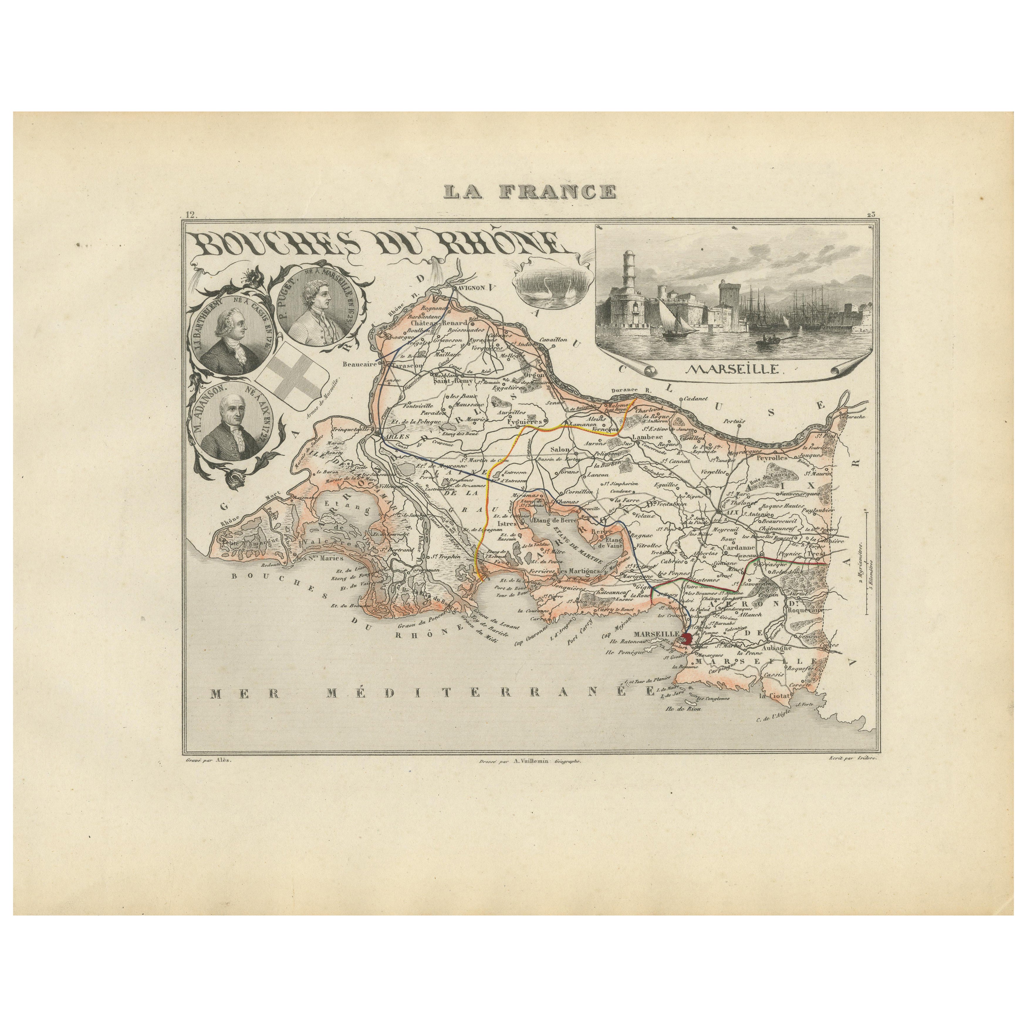
Map of Bouches-du-Rhône France with Marseille and Rhône Delta, 19th Century
Map of Bouches-du-Rhône France with Marseille and Rhône Delta, 19th Century
Description:
This finely engraved 19th-century map of the Bouches-du-Rhône department in southeastern Fra...
Kategorie
Antik, Mittleres 19. Jahrhundert, Französisch, Landkarten
Materialien
Papier
Map of Côtes-du-Nord France with Saint-Brieuc and Brittany Coastline, c.1850
Map of Côtes-du-Nord France with Saint-Brieuc and Brittany Coastline, 19th c
Description:
This elegant 19th-century map of Côtes-du-Nord, the historic name for what is now known as ...
Kategorie
Antik, Mittleres 19. Jahrhundert, Französisch, Landkarten
Materialien
Papier

Map of Côte-d'Or France with Dijon and Burgundy Wine Region, 19th Century
Map of Côte-d'Or France with Dijon and Burgundy Wine Region, 19th Century
Description:
This beautifully engraved 19th-century map of Côte-d'Or, located in the historic region of Bur...
Kategorie
Antik, Mittleres 19. Jahrhundert, Französisch, Landkarten
Materialien
Papier

Map of Aisne France with Soissons and Champagne Vineyards by Vuillemin, 19th c
Map of Aisne France with Soissons and Champagne Vineyards by Vuillemin, 19th c
Description:
This richly detailed 19th-century engraved and hand-colored map of the department of Aisn...
Kategorie
Antik, Mittleres 19. Jahrhundert, Französisch, Landkarten
Materialien
Papier

Map of Ariège France with Foix and Pyrenees Landscape by Vuillemin, 19th c
Map of Ariège France with Foix and Pyrenees Landscape by Vuillemin, 19th c
Description:
This beautifully detailed 19th-century map of the Ariège department in southwestern France wa...
Kategorie
Antik, Mittleres 19. Jahrhundert, Französisch, Landkarten
Materialien
Papier

Das könnte Ihnen auch gefallen
Große Karte von Frankreich aus dem 19.
Große Karte von Frankreich aus dem 19. Jahrhundert.
Bemerkenswerter Zustand, mit einer angenehmen altersbedingten Patina.
Kürzlich gerahmt.
Frankreich CIRCA 1874.
Kategorie
Antik, Spätes 19. Jahrhundert, Französisch, Landkarten
Materialien
Leinen, Papier

Karte der Wiener Haute Vienne – Originallithographie – 19. Jahrhundert
Die Karte der Haute Vienne ist eine Original-Lithographie, die von einem Anonymer Graveur des 19. Jahrhunderts.
Gedruckt in der Reihe der "Frankreich pittoresk".
Unter dem Titel ...
Kategorie
19. Jahrhundert, Moderne, Figurative Drucke
Materialien
Lithografie

L'Isere, Frankreich. Antike Karte der französischen Abteilung, 1856
Von Victor Levasseur
dept. de L'Isere", Stahlstich mit Originalumriss von Hand koloriert, 1856, aus Levasseurs "Atlas National Illustre".
Dieses Gebiet ist bekannt für die Herstellung von Bleu du Verco...
Kategorie
19. Jahrhundert, Naturalismus, Landschaftsdrucke
Materialien
Gravur

Frankreich, Nordteil. Antike Atlas-Karte des Jahrhunderts
Der Jahrhundertatlas. Frankreich, Nordteil'.
Originale antike Karte, 1903.
Insetkarten von "Frankreich in den Provinzen" und "Paris und Umgebung".
Zentrale Falte wie ausgestellt. N...
Kategorie
Frühes 20. Jahrhundert, Viktorianisch, Mehr Drucke
Materialien
Lithografie

Map of Rhne - Original-Radierung - 19. Jahrhundert
Die Karte der Rhône ist eine antike Original-Radierung, die von einem anonymen Graveur aus dem 19.
Gedruckt in Serien von "France Pittoresque" oben in der Mitte.
Der Erhaltungszust...
Kategorie
19. Jahrhundert, Moderne, Figurative Drucke
Materialien
Radierung

Aude, Frankreich. Antike Karte einer französischen Abteilung, 1856
Von Victor Levasseur
dept. de L' Aude", Stahlstich mit Originalumriss von Hand koloriert, 1856, aus Levasseurs "Atlas National Illustre".
Diese Region Frankreichs ist berühmt für ihre große Vielfalt an...
Kategorie
19. Jahrhundert, Naturalismus, Landschaftsdrucke
Materialien
Gravur
