Objekte ähnlich wie Map of Finistère France with Brest, Quimper and Brittany Coastline, 19th Century


Möchten Sie mehr Bilder oder Videos?
Zusätzliche Bilder oder Videos von dem*der Anbieter*in anfordern
1 von 10
Map of Finistère France with Brest, Quimper and Brittany Coastline, 19th Century
140 €Einschließlich MwSt.
Angaben zum Objekt
Map of Finistère France with Brest, Quimper and Brittany Coastline, 19th Century
Description:
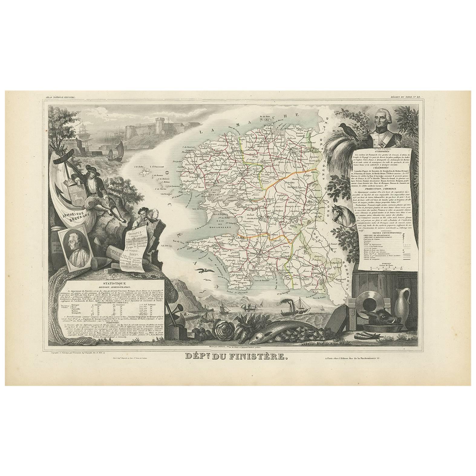
This richly engraved 19th-century map of Finistère, the westernmost department of mainland France, was drawn by Alexandre Vuillemin and published by Migeon in Paris for the *Nouvel Atlas Illustré*. The map offers a finely detailed view of this culturally distinct and geographically dramatic region, renowned for its rugged coastline, maritime heritage, and Celtic traditions.
Finistère, meaning "end of the land" in Latin, is presented here with its departmental boundaries hand-colored in soft pink. The map clearly delineates towns, roads, rivers, and coastal features, including the Crozon Peninsula and islands such as Ouessant and Sein. Quimper, the prefecture, and Brest, a strategic naval base, are prominently marked along with other key towns like Morlaix, Douarnenez, and Concarneau.
In the lower left corner is an engraved vignette of the harbor at Quimper, depicting a sailing vessel, waterfront buildings, and a view of the Gothic cathedral. On the right stands a full-length statue of a revolutionary figure, General Hoche, who led troops in Brittany during the counter-revolutionary uprisings. The top left features the coat of arms of Finistère, bearing a ship and marine imagery appropriate to this seafaring region.
Finistère forms part of Brittany (Bretagne), a region steeped in Celtic culture, Breton language, and maritime history. While not a major wine-producing area, the department is famous for its cider, seafood (especially oysters and scallops), buckwheat galettes, and dairy products. Its coastal geography and strong winds have made it a critical location for lighthouses, fishing ports, and naval defenses for centuries.
This antique map is both decorative and historically informative, ideal for collectors interested in Brittany, French maritime history, or regional ethnography. It reflects the cultural independence and dramatic geography of France’s far western frontier.
Condition summary:
Very good condition with minor age toning and light foxing near the edges. Engraved lines are crisp and the original hand coloring remains clean and consistent.
Framing tips:
A rustic oak or driftwood frame complements the coastal and Breton character of the map. A cream or light gray mat enhances the engraving and soft pink tones. UV-protective glass is recommended for preservation and clarity.
- Maße:Höhe: 32,5 cm (12,8 in)Breite: 26,1 cm (10,28 in)Tiefe: 0,2 mm (0,01 in)
- Materialien und Methoden:Papier,Graviert
- Herkunftsort:
- Zeitalter:
- Herstellungsjahr:circa 1850
- Zustand:Very good condition with minor age toning and light foxing near the edges. Engraved lines are crisp and the original hand coloring remains clean and consistent.
- Anbieterstandort:Langweer, NL
- Referenznummer:Anbieter*in: BG-13331-281stDibs: LU3054345363902
Anbieterinformationen
5,0
Anerkannte Anbieter*innen
Diese renommierten Anbieter*innen sind führend in der Branche und repräsentieren die höchste Klasse in Sachen Qualität und Design.
Platin-Anbieter*in
Premium-Anbieter*innen mit einer Bewertung über 4,7 und 24 Stunden Reaktionszeit
Gründungsjahr 2009
1stDibs-Anbieter*in seit 2017
2.531 Verkäufe auf 1stDibs
Typische Antwortzeit: <1 Stunde
- VersandAngebot wird abgerufen …Versand von: Langweer, Niederlande
- Rückgabebedingungen
Einige Inhalte dieser Seite wurden automatisch übersetzt. Daher kann 1stDibs nicht die Richtigkeit der Übersetzungen garantieren. Englisch ist die Standardsprache dieser Website.
Authentizitätsgarantie
Im unwahrscheinlichen Fall eines Problems mit der Echtheit eines Objekts kontaktieren Sie uns bitte innerhalb von 1 Jahr für eine volle Rückerstattung. DetailsGeld-Zurück-Garantie
Wenn Ihr Objekt nicht der Beschreibung entspricht, beim Transport beschädigt wurde oder nicht ankommt, kontaktieren Sie uns bitte innerhalb von 7 Tagen für eine vollständige Rückerstattung. DetailsStornierung innerhalb von 24 Stunden
Sie können Ihren Kauf jederzeit innerhalb von 24 Stunden stornieren, ohne jegliche Gründe dafür angeben zu müssen.Geprüfte Anbieter*innen
Unsere Anbieter*innen unterliegen strengen Dienstleistungs- und Qualitätsstandards, wodurch wir die Seriosität unserer Angebote gewährleisten können.Preisgarantie
Wenn Sie feststellen, dass ein*e Anbieter*in dasselbe Objekt anderswo zu einem niedrigeren Preis anbietet, werden wir den Preis entsprechend anpassen.Zuverlässige weltweite Lieferung
Unsere erstklassigen Versandunternehmen bieten spezielle Versandoptionen weltweit, einschließlich individueller Lieferung.Mehr von diesem*dieser Anbieter*in
Alle anzeigenMap of Côtes-du-Nord France with Saint-Brieuc and Brittany Coastline, c.1850
Map of Côtes-du-Nord France with Saint-Brieuc and Brittany Coastline, 19th c
Description:
This elegant 19th-century map of Côtes-du-Nord, the historic name for what is now known as ...
Kategorie
Antik, Mittleres 19. Jahrhundert, Französisch, Landkarten
Materialien
Papier

Antike Karte der Finistère „Frankreich“ von V. Levasseur, 1854
Von Victor Levasseur
Antike Karte mit dem Titel 'Dépt. du Finistère'. Karte des französischen Departements Finistère, Bretagne, Frankreich. Diese Region Frankreichs ist bekannt für die Herstellung von Ap...
Kategorie
Antik, Mittleres 19. Jahrhundert, Landkarten
Materialien
Papier
144 € Angebotspreis
20 % Rabatt
Map of Allier France with Saint-Pourçain Wine Region by Vuillemin, 19th c
Map of Allier France with Saint-Pourçain Wine Region by Vuillemin, 19th c
This decorative 19th-century map of Allier, a central department of France, comes from the celebrated Nouve...
Kategorie
Antik, Mittleres 19. Jahrhundert, Französisch, Landkarten
Materialien
Papier

Handkolorierte Karte von Nordwest-Frankreich - Bretagne bis Loire, 1858
Antike Karte von Nordwest-Frankreich - Stülpnagel-Stich, Justus Perthes 1858
Beeindruckend detaillierte Karte des nordwestlichen Frankreichs aus der Mitte des 19. Jahrhunderts mit d...
Kategorie
Antik, Mittleres 19. Jahrhundert, Deutsch, Landkarten
Materialien
Papier
Map of Aisne France with Soissons and Champagne Vineyards by Vuillemin, 19th c
Map of Aisne France with Soissons and Champagne Vineyards by Vuillemin, 19th c
Description:
This richly detailed 19th-century engraved and hand-colored map of the department of Aisn...
Kategorie
Antik, Mittleres 19. Jahrhundert, Französisch, Landkarten
Materialien
Papier

Map of Gard France with Pont du Gard and Wine Regions by Vuillemin, 19th c
Title: Map of Gard France with Pont du Gard and Wine Regions by Vuillemin, 19th c
Description:
This finely engraved 19th-century map of the department of Gard in southern France was...
Kategorie
Antik, Mittleres 19. Jahrhundert, Französisch, Landkarten
Materialien
Papier

Das könnte Ihnen auch gefallen
Große Karte von Frankreich aus dem 19.
Große Karte von Frankreich aus dem 19. Jahrhundert.
Bemerkenswerter Zustand, mit einer angenehmen altersbedingten Patina.
Kürzlich gerahmt.
Frankreich CIRCA 1874.
Kategorie
Antik, Spätes 19. Jahrhundert, Französisch, Landkarten
Materialien
Leinen, Papier

Kartenkarte Frankreichs – Radierung – 1820
Karte von Frankreich ist eine Original-Radierung von einem unbekannten Künstler des 19. Jahrhunderts im Jahr 1820 realisiert.
Sehr guter Zustand auf zwei weißen Blättern, die in der...
Kategorie
1820er, Moderne, Figurative Drucke
Materialien
Radierung

Frankreich, Nordteil. Antike Atlas-Karte des Jahrhunderts
Der Jahrhundertatlas. Frankreich, Nordteil'.
Originale antike Karte, 1903.
Insetkarten von "Frankreich in den Provinzen" und "Paris und Umgebung".
Zentrale Falte wie ausgestellt. N...
Kategorie
Frühes 20. Jahrhundert, Viktorianisch, Mehr Drucke
Materialien
Lithografie

Indre und Loire, Frankreich. Antike Karte einer französischen Abteilung, 1856
Von Victor Levasseur
dept. d'Indre et Loire", Stahlstich mit Originalumriss von Hand koloriert, 1856, aus Levasseurs "Atlas National Illustre".
Dieses Gebiet ist bekannt für die Herstellung von Chenin ...
Kategorie
19. Jahrhundert, Naturalismus, Landschaftsdrucke
Materialien
Gravur

La Gironde, Frankreich. Antike Karte einer französischen Abteilung, 1856
Von Victor Levasseur
la Gironde", Stahlstich mit originaler Handkolorierung der Umrisse, 1856, aus dem Atlas National Illustre von Levasseur.
Dieses Departement an der Küste ist der Sitz der Weinregion...
Kategorie
19. Jahrhundert, Naturalismus, Landschaftsdrucke
Materialien
Gravur

Karte der Vendée - Radierung - 19. Jahrhundert
Die Karte der Vendée ist eine Radierung eines anonymen Graveurs aus dem 19. Jahrhundert.
Gedruckt in einer Reihe von "France Pittoresque" in der oberen Mitte.
Der Erhaltungszustand...
Kategorie
19. Jahrhundert, Moderne, Figurative Drucke
Materialien
Radierung
