Objekte ähnlich wie Cartography Print 1852 – Educational Diagram of Mountains, Winds, and Reefs


Möchten Sie mehr Bilder oder Videos?
Zusätzliche Bilder oder Videos von dem*der Anbieter*in anfordern
1 von 9
Cartography Print 1852 – Educational Diagram of Mountains, Winds, and Reefs
240 €pro Objekt|Einschließlich MwSt.
Menge
Versand
Angebot wird abgerufen …Das Versprechen von 1stDibs:
Authentizitätsgarantie,
Geld-Zurück-Garantie,
Stornierung innerhalb von 24 Stunden
Angaben zum Objekt
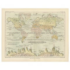
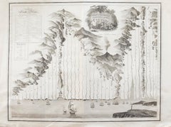
Cartographic Masterpiece 1852 – Illustrated Guide to Map Symbols and Climate
Description:
This original 1852 plate titled "Illustrations of Chartography Plate I" offers a fascinating and visually rich introduction to 19th-century mapping techniques. Published in A School Atlas of Physical Geography by the eminent Scottish cartographer Alexander Keith Johnston, the plate served as an educational tool designed to teach the principles of cartography, climatology, geology, and meteorology.
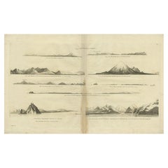
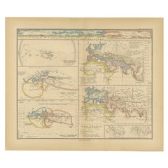
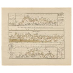
The detailed engravings include symbolic representations used on maps, such as forms of mountains, volcanoes, reef systems, and rainfall diagrams, along with charts of wind directions, cloud formations, and the system of contouring. Particularly notable is the lower section titled "Climatography," which combines scientific elements into a picturesque landscape featuring a rainbow, tornado, sea spray, and a mountain chain—all stylized to represent the natural forces shaping Earth’s surface.
Johnston was a leading cartographer of the Victorian period, and this atlas was used widely in schools and scientific circles for its clarity and innovative visual methods. The plate was engraved and printed by W. & A.K. Johnston, his family firm, which gained a global reputation for excellence in educational publishing.
This chart is not only historically significant but also aesthetically appealing, making it an ideal piece for collectors of antique scientific prints or for elegant interior decoration with an academic flair.
Condition:
Very good antique condition. Clean impression with light age-toning and minimal foxing. Edges show only minor wear. Fold in middle as issued. Suitable for immediate display or archival framing.
Tips for Framing:
Mat in light ivory or soft taupe to highlight the warm aged tones. Use a slim black or walnut wood frame for a classic scientific look that pairs well with academic or minimalist interiors.
- Maße:Höhe: 27,4 cm (10,79 in)Breite: 34,5 cm (13,59 in)Tiefe: 0,2 mm (0,01 in)
- Materialien und Methoden:
- Zeitalter:
- Herstellungsjahr:1852
- Zustand:Very good antique condition. Clean impression with light age-toning and minimal foxing. Edges show only minor wear. Fold in middle as issued. Suitable for immediate display or archival framing.
- Anbieterstandort:Langweer, NL
- Referenznummer:Anbieter*in: BG-13207-11stDibs: LU3054345370352
Anbieterinformationen
5,0
Anerkannte Anbieter*innen
Diese renommierten Anbieter*innen sind führend in der Branche und repräsentieren die höchste Klasse in Sachen Qualität und Design.
Platin-Anbieter*in
Premium-Anbieter*innen mit einer Bewertung über 4,7 und 24 Stunden Reaktionszeit
Gründungsjahr 2009
1stDibs-Anbieter*in seit 2017
2.493 Verkäufe auf 1stDibs
Typische Antwortzeit: <1 Stunde
- VersandAngebot wird abgerufen …Versand von: Langweer, Niederlande
- Rückgabebedingungen
Einige Inhalte dieser Seite wurden automatisch übersetzt. Daher kann 1stDibs nicht die Richtigkeit der Übersetzungen garantieren. Englisch ist die Standardsprache dieser Website.
Authentizitätsgarantie
Im unwahrscheinlichen Fall eines Problems mit der Echtheit eines Objekts kontaktieren Sie uns bitte innerhalb von 1 Jahr für eine volle Rückerstattung. DetailsGeld-Zurück-Garantie
Wenn Ihr Objekt nicht der Beschreibung entspricht, beim Transport beschädigt wurde oder nicht ankommt, kontaktieren Sie uns bitte innerhalb von 7 Tagen für eine vollständige Rückerstattung. DetailsStornierung innerhalb von 24 Stunden
Sie können Ihren Kauf jederzeit innerhalb von 24 Stunden stornieren, ohne jegliche Gründe dafür angeben zu müssen.Geprüfte Anbieter*innen
Unsere Anbieter*innen unterliegen strengen Dienstleistungs- und Qualitätsstandards, wodurch wir die Seriosität unserer Angebote gewährleisten können.Preisgarantie
Wenn Sie feststellen, dass ein*e Anbieter*in dasselbe Objekt anderswo zu einem niedrigeren Preis anbietet, werden wir den Preis entsprechend anpassen.Zuverlässige weltweite Lieferung
Unsere erstklassigen Versandunternehmen bieten spezielle Versandoptionen weltweit, einschließlich individueller Lieferung.Mehr von diesem*dieser Anbieter*in
Alle anzeigenWind and Hurricane Map by A.K. Johnston – Meteorological Chart 1852
Wind and Hurricane Map by A.K. Johnston – Meteorological Chart 1852
This scientifically significant 1852 map titled "The Distribution of the Constant, Periodical & Variable Winds Ov...
Kategorie
Antik, Mittleres 19. Jahrhundert, Schottisch, Drucke
Materialien
Papier

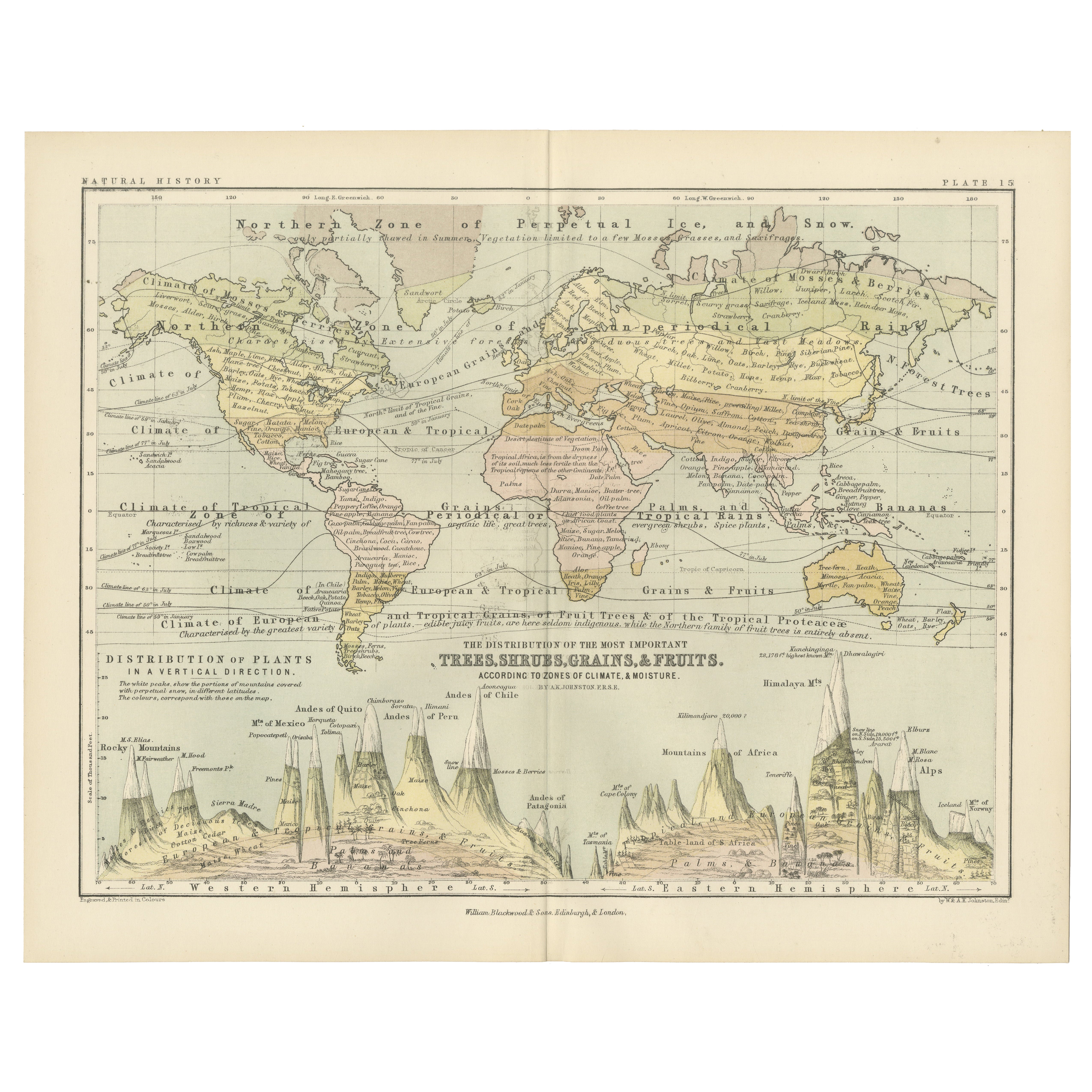
Botanical Map by A.K. Johnston – Global Plant Distribution Chart 1852
Botanical Map by A.K. Johnston – Global Plant Distribution Chart 1852
This remarkable antique chart titled "The Distribution of the Most Important Trees, Shrubs, Grains, & Fruits Ac...
Kategorie
Antik, Mittleres 19. Jahrhundert, Schottisch, Drucke
Materialien
Papier
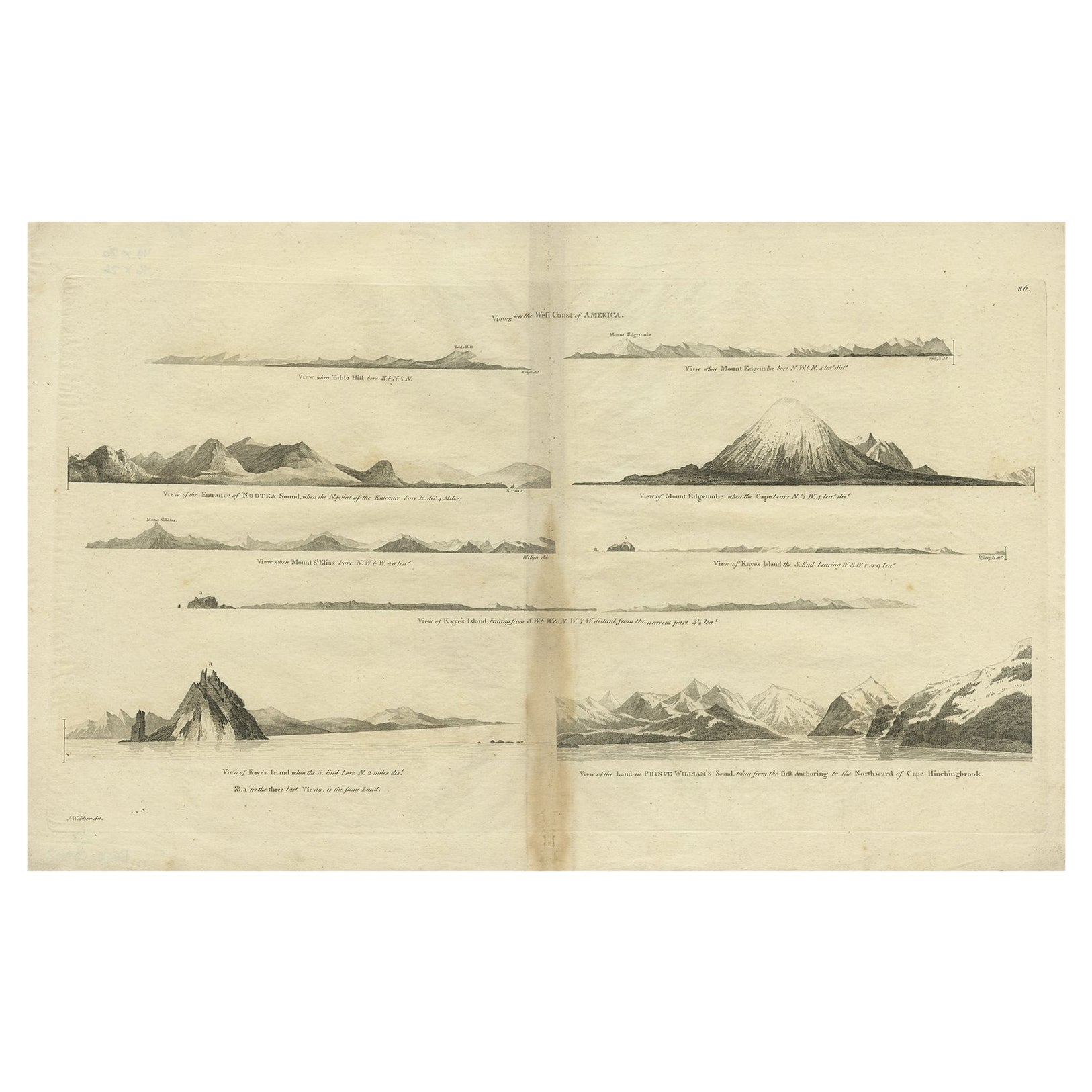
Antike Karte der Westküste Amerikas mit Inselansichten, ca. 1784
Antiker Druck mit dem Titel 'Ansichten der Westküste Amerikas (..)'.
Küstenansichten von verschiedenen Inseln der amerikanischen Küste. Stammt aus einer Ausgabe von Cooks Voyages...
Kategorie
Antik, 1780er, Landkarten
Materialien
Papier
360 € Angebotspreis
20 % Rabatt
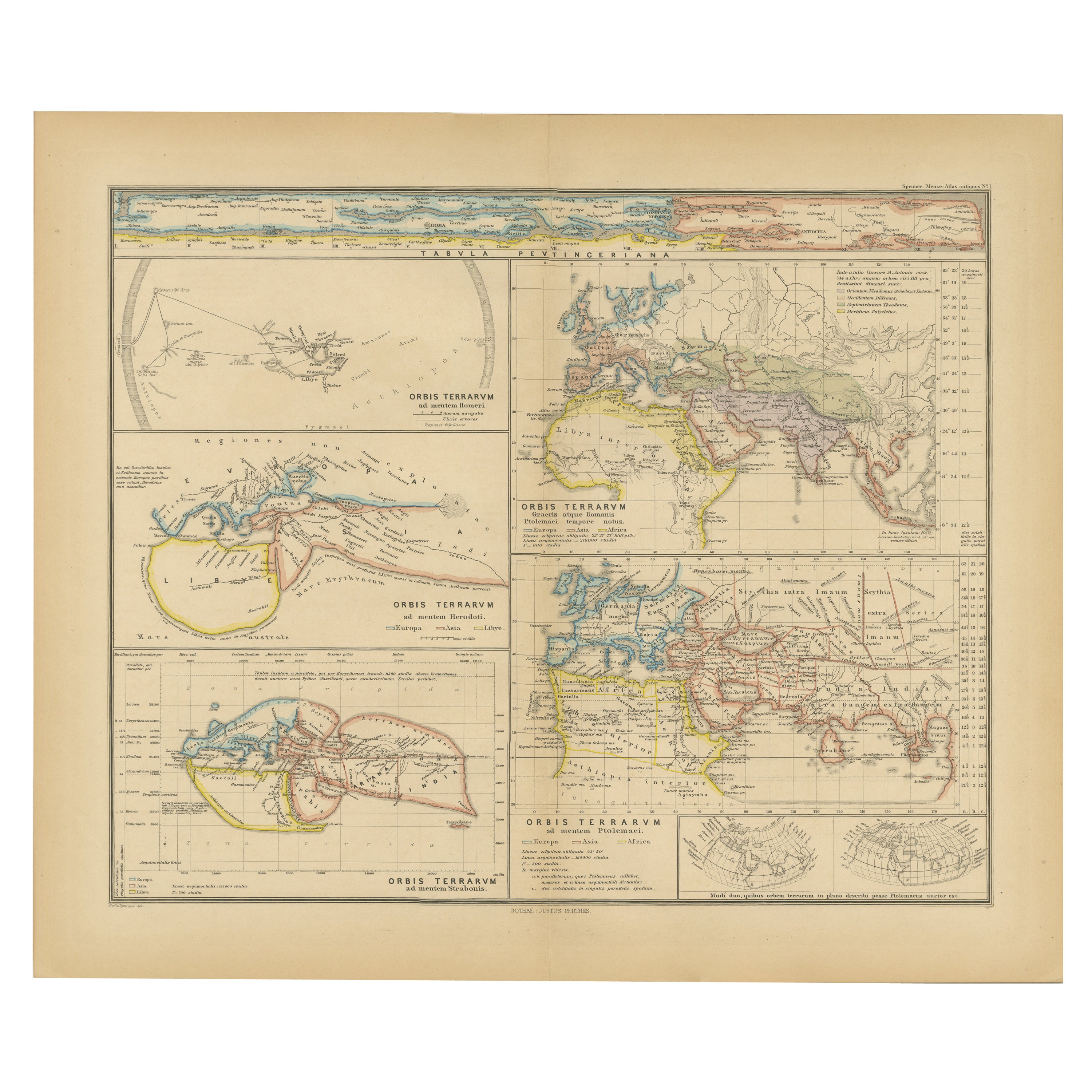
Originales altes zusammengesetztes Werk mit mehreren Karten der antiken Welt auf einem Blatt, 1880
Diese antike Originalkarte stammt aus dem "Atlas Antiquus" von Karl Spruner von Merz, der später von Theodorus Menke herausgegeben wurde. Die Karte ist eine detaillierte Darstellung ...
Kategorie
Antik, 1880er, Landkarten
Materialien
Papier
296 € Angebotspreis
20 % Rabatt
Kostenloser Versand
Antike Karte mit der Darstellung der Verteilung der Pflanzen von Johnston, '1850'
Antike Karte mit dem Titel "Geografische Verbreitung von Pflanzen". Originale antike Karte, die die Verbreitung von Pflanzen zeigt. Diese Karte stammt aus "The Physical Atlas of Natu...
Kategorie
Antik, Mittleres 19. Jahrhundert, Landkarten
Materialien
Papier

160 € Angebotspreis
20 % Rabatt
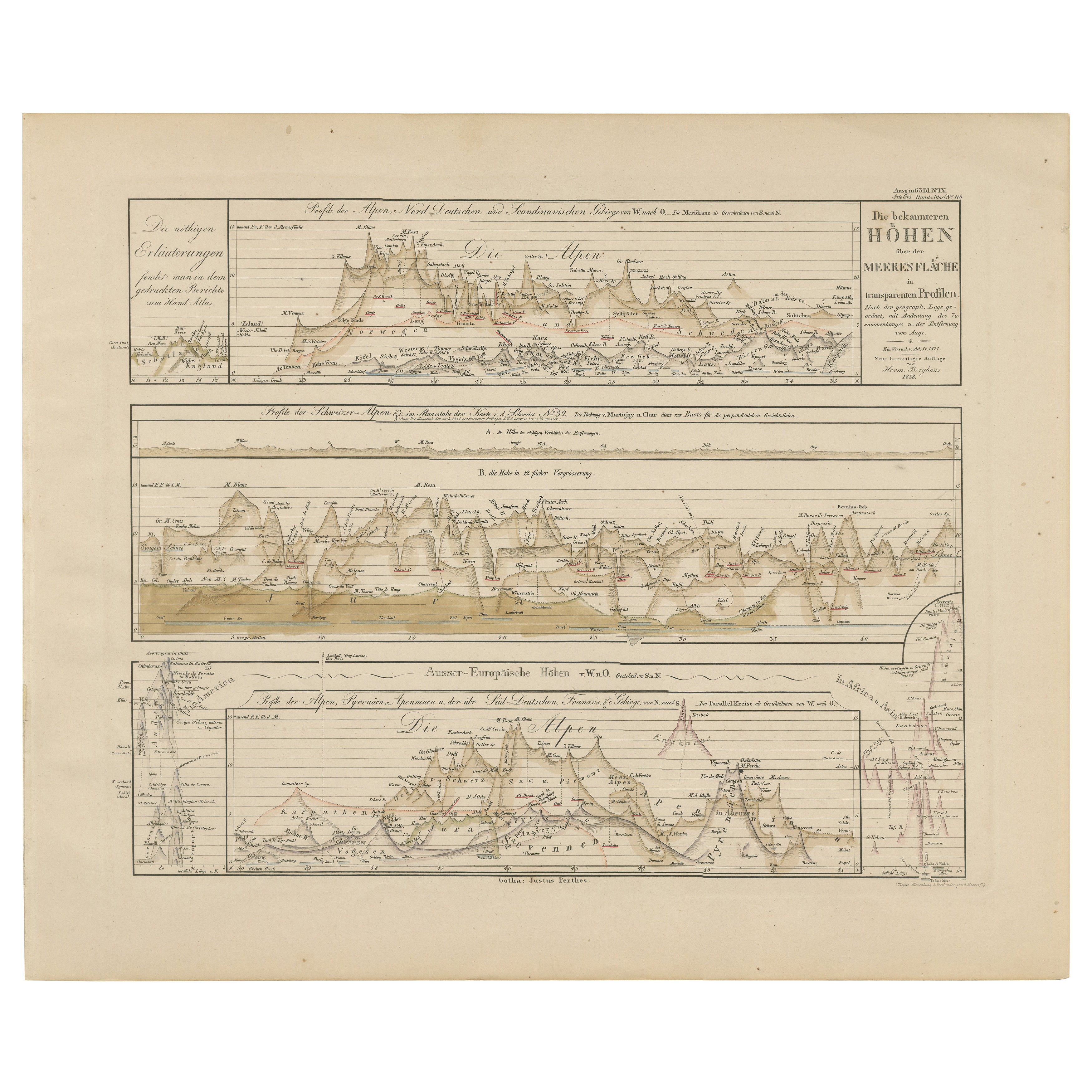
Gebirgshöhenprofile - Alpen, Pyrenäen, Anden & Welthöhen 1857
Gebirgshöhenprofile - Alpen, Pyrenäen, Anden & Welthöhen 1857
Dieser faszinierende antike Druck zeigt vergleichende Höhenprofile mit dem Titel "Die bekannteren Höhen über der Meeres...
Kategorie
Antik, Mittleres 19. Jahrhundert, Deutsch, Landkarten
Materialien
Papier
Das könnte Ihnen auch gefallen
Hemisphäre des Neuen Kontinents – Antike Karte von J.G. Heck - 1834.
Von Johann Georg Heck
Hemisphäre des neuen Kontinents ist ein um 1760 entstandenes Kunstwerk von Johann Georg Heck
Original-Farbdruck.
Guter Zustand mit Ausnahme der Vergilbung des Papiers und der Einrisse am Rand.
Originaltitel Hemisphere du Nouveau Continent et ses Antipodes. Gedruckt bei Engelmann & Compagnie, S.F., Paris.
Dieser Druck ist die Tafel Nr. 7 aus "Atlas geographique, astronomique et historique, servant a l'intelligence de l'histoire ancienne, du moyen age et moderne et a la lecture des voyages les plus recens. Dresse d'apres les meilleurs materiaux tant francais qu'etrangers conformement aus progres de la science, par J.G. Mist."
Johann Georg Heck (1795 - 1857) war ein deutscher Buchhändler...
Kategorie
1830er, Moderne, Figurative Drucke
Materialien
Radierung

Old Map mit der Darstellung der gesamten Erdoberfläche in sechs Teilen, Frankreich 1850
Karte der gesamten Erdoberfläche, die in sechs Teile unterteilt ist und die Position der Völker auf der Erde darstellt, ausgehend von der Annahme, dass es unmöglich ist, dass jedes V...
Kategorie
Antik, Mittleres 19. Jahrhundert, Französisch, Landkarten
Materialien
Glas, Holz, Papier

Karte der Welt – Original-Radierung – 1820
Die Weltkarte ist eine Original-Radierung eines unbekannten Künstlers des 19. Jahrhunderts aus dem Jahr 1820.
Sehr guter Zustand auf zwei in der Mitte verbundenen weißen Blättern.
...
Kategorie
1820er, Moderne, Figurative Drucke
Materialien
Radierung

Original Antike Karte der westlichen Hemisphäre von Dower, circa 1835
Schöne Karte der westlichen Hemisphäre
Gezeichnet und gestochen von J. Dower
Herausgegeben von Orr & Smith. C.1835
Ungerahmt.
Kostenloser Versand
Kategorie
Antik, 1830er, Englisch, Landkarten
Materialien
Papier

Große Original-Antike Originalkarte der Welt, Fullarton, um 1870
Großartige Karte der Welt. Zeigt beide Hemisphären
Aus dem berühmten Royal Illustrated Atlas
Lithografie. Originalfarbe.
Veröffentlicht von Fullarton, Edinburgh, um 1870
Ungerah...
Kategorie
Antik, 1870er, Schottisch, Landkarten
Materialien
Papier

John Thomson (1777-1840) - 1830 Kartengravur, Die Flüsse der Welt
Von John Thomson
Eine schöne gestochene Tabelle mit den Längen der wichtigsten Flüsse der Welt, die aus der zweiten Ausgabe von John Thomsons "New General Atlas" von 1830 stammt. Auf dem Papier.
Kategorie
Frühes 19. Jahrhundert, Mehr Drucke
Materialien
Gravur
306 € Angebotspreis
20 % Rabatt