Objekte ähnlich wie Geological Map of Europe by A.K. Johnston – Mountains and Valleys 1852


Möchten Sie mehr Bilder oder Videos?
Zusätzliche Bilder oder Videos von dem*der Anbieter*in anfordern
1 von 10
Geological Map of Europe by A.K. Johnston – Mountains and Valleys 1852
260 €pro Objekt|Einschließlich MwSt.
Menge
Versand
Angebot wird abgerufen …Das Versprechen von 1stDibs:
Authentizitätsgarantie,
Geld-Zurück-Garantie,
Stornierung innerhalb von 24 Stunden
Angaben zum Objekt
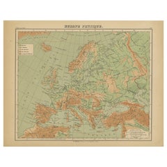
Geological Map of Europe by A.K. Johnston – Mountains and Valleys 1852
This elegant 1852 map titled "The Mountains, Table Lands, Plains & Valleys of Europe" was designed by the acclaimed Scottish geographer Alexander Keith Johnston and published by William Blackwood & Sons, Edinburgh and London. Issued as Plate 5 in Johnston’s pioneering work *The Physical Atlas of Natural Phenomena*, this map presents a physical topographic view of Europe with a focus on land elevation and terrain structure, rather than political borders.
Rendered in soft shades of beige, green, and blue, the map clearly delineates Europe’s major mountain ranges, including the Alps, Pyrenees, Carpathians, Apennines, and the Scandinavian Mountains. Valleys, upland plateaus, and lowlands are carefully shaded and labeled, giving a three-dimensional sense of the landscape. The careful use of hachuring and color gradients creates a tactile impression of Europe’s relief, from the Scottish Highlands to the Ural Mountains.
Rather than showing countries, the map categorizes the land by geological and geomorphological features. The title and key in the lower right explain the distinctions between highlands, tablelands, and low plains, emphasizing natural geography over human boundaries. This approach reflects the 19th-century scientific movement toward thematic cartography—maps made not to navigate or govern, but to understand physical phenomena.
Alexander Keith Johnston (1804–1871), Geographer in Ordinary to the Queen for Scotland, was one of the most respected mapmakers of the Victorian era. His *Physical Atlas* was a groundbreaking work in visual science, and among the first to systematically map climate, geology, hydrology, and landforms across the globe.
This plate is a beautifully executed example of early data visualization and remains highly relevant for collectors of antique scientific prints, students of European geography, or those seeking refined decorative maps for libraries, studies, or offices.
Condition and framing tips:
Very good antique condition with minor toning and slight edge wear. The print retains sharp detail and gentle original coloring. Best displayed in a black or walnut frame with a warm ivory or soft grey mat to highlight the topographic textures and historic typographic style. Ideal for natural history interiors or scholarly settings.
- Maße:Höhe: 27,4 cm (10,79 in)Breite: 34,5 cm (13,59 in)Tiefe: 0,2 mm (0,01 in)
- Materialien und Methoden:
- Herkunftsort:
- Zeitalter:
- Herstellungsjahr:1852
- Zustand:Very good condition. Light overall toning near the margins. The paper remains strong and well-preserved. Folding line as issued.
- Anbieterstandort:Langweer, NL
- Referenznummer:Anbieter*in: BG-13207-51stDibs: LU3054345386522
Anbieterinformationen
5,0
Anerkannte Anbieter*innen
Diese renommierten Anbieter*innen sind führend in der Branche und repräsentieren die höchste Klasse in Sachen Qualität und Design.
Platin-Anbieter*in
Premium-Anbieter*innen mit einer Bewertung über 4,7 und 24 Stunden Reaktionszeit
Gründungsjahr 2009
1stDibs-Anbieter*in seit 2017
2.510 Verkäufe auf 1stDibs
Typische Antwortzeit: <1 Stunde
- VersandAngebot wird abgerufen …Versand von: Langweer, Niederlande
- Rückgabebedingungen
Einige Inhalte dieser Seite wurden automatisch übersetzt. Daher kann 1stDibs nicht die Richtigkeit der Übersetzungen garantieren. Englisch ist die Standardsprache dieser Website.
Authentizitätsgarantie
Im unwahrscheinlichen Fall eines Problems mit der Echtheit eines Objekts kontaktieren Sie uns bitte innerhalb von 1 Jahr für eine volle Rückerstattung. DetailsGeld-Zurück-Garantie
Wenn Ihr Objekt nicht der Beschreibung entspricht, beim Transport beschädigt wurde oder nicht ankommt, kontaktieren Sie uns bitte innerhalb von 7 Tagen für eine vollständige Rückerstattung. DetailsStornierung innerhalb von 24 Stunden
Sie können Ihren Kauf jederzeit innerhalb von 24 Stunden stornieren, ohne jegliche Gründe dafür angeben zu müssen.Geprüfte Anbieter*innen
Unsere Anbieter*innen unterliegen strengen Dienstleistungs- und Qualitätsstandards, wodurch wir die Seriosität unserer Angebote gewährleisten können.Preisgarantie
Wenn Sie feststellen, dass ein*e Anbieter*in dasselbe Objekt anderswo zu einem niedrigeren Preis anbietet, werden wir den Preis entsprechend anpassen.Zuverlässige weltweite Lieferung
Unsere erstklassigen Versandunternehmen bieten spezielle Versandoptionen weltweit, einschließlich individueller Lieferung.Mehr von diesem*dieser Anbieter*in
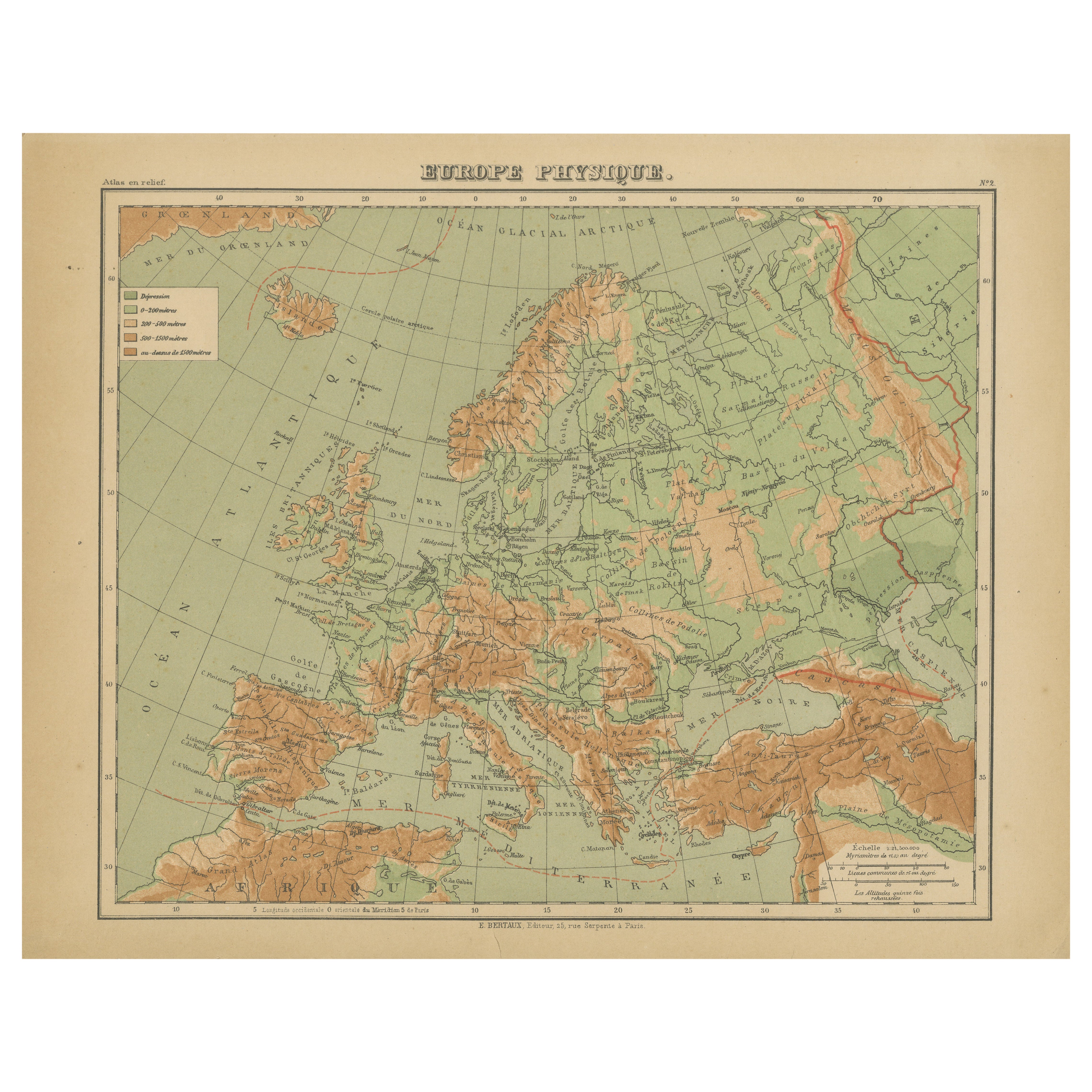
Alle anzeigenRelief-Atlas Karte von Europa von Hachette - Antique French Map c.1883
Antike Europakarte - Physikalische Reliefkarte von Hachette, um 1883
Beschreibung:
Diese antike Karte mit dem Titel "Europe Physique" wurde um 1883 von Hachette in Paris herausgegeb...
Kategorie
Antik, Spätes 19. Jahrhundert, Französisch, Landkarten
Materialien
Papier
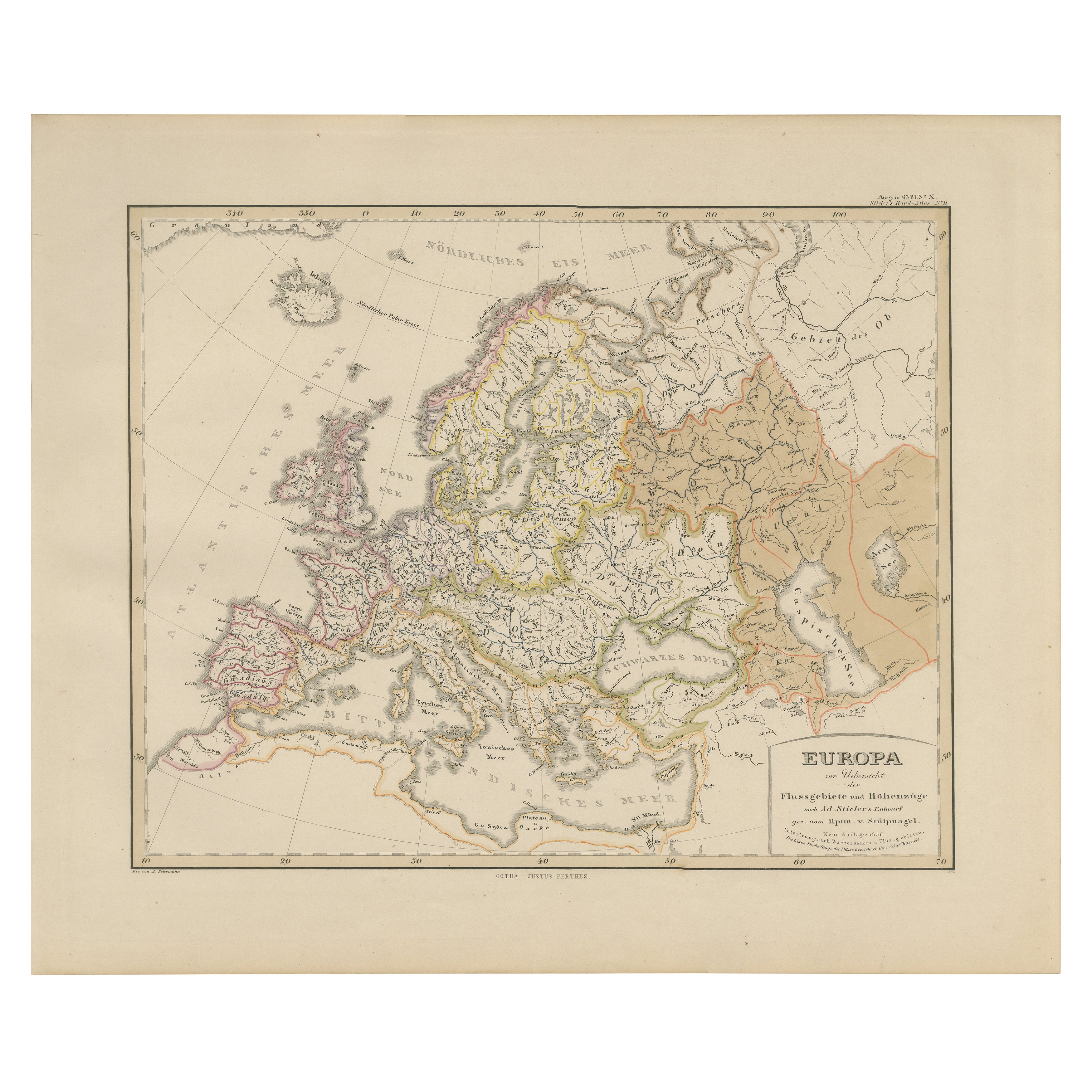
Europakarte - Flüsse, Einzugsgebiete und Höhenlagen, veröffentlicht im Jahr 1857
Europa-Karte - Flüsse, Wasserscheiden und Höhenlagen 1857
Dieser schöne antike Druck zeigt Europa mit seinen Flusssystemen und Wassereinzugsgebieten und trägt den Titel "Europa zur ...
Kategorie
Antik, Mittleres 19. Jahrhundert, Deutsch, Landkarten
Materialien
Papier
Antike Europakarte, 1903, mit komplizierten politischen Grenzen und reichen Details
Titel: Antike Europakarte, 1903, mit komplizierten politischen Abgrenzungen und reichem Detailreichtum
Beschreibung:
Diese antike Karte mit dem Titel "Europa" ist ein fein gestochen...
Kategorie
Frühes 20. Jahrhundert, Landkarten
Materialien
Papier

Antike Europakarte von W. G. Blackie, 1859
Antike Karte mit dem Titel 'Europa'. Original antike Landkarte von Europa. Diese Karte stammt aus dem "Imperial Atlas of Modern Geography". Herausgegeben von W. G. Blackie, 1859.
Kategorie
Antik, Mittleres 19. Jahrhundert, Landkarten
Materialien
Papier

200 € Angebotspreis
20 % Rabatt
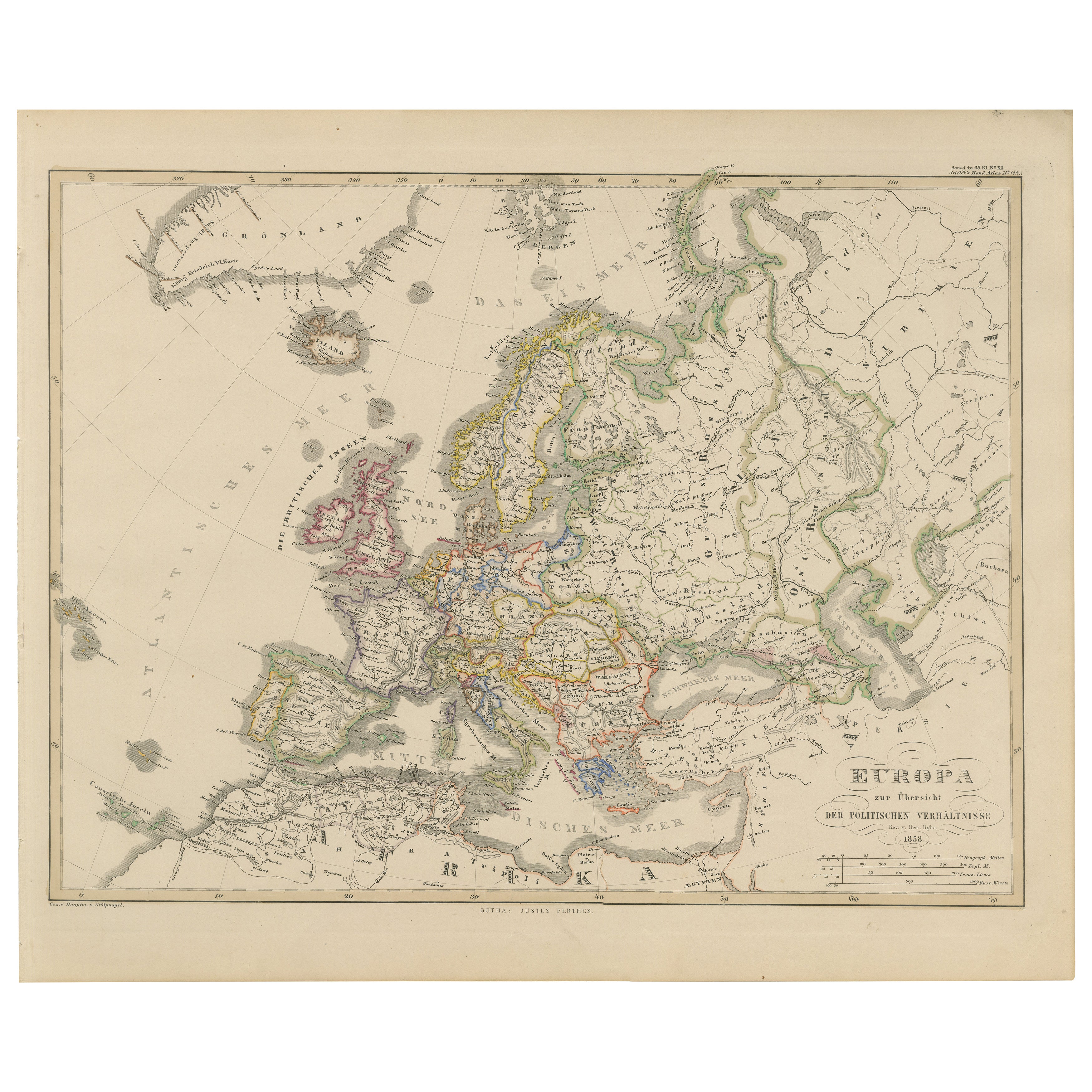
Europakarte - Politische Teilungen und Grenzen, veröffentlicht im Jahr 1858
Europa Karte - Politische Teilungen und Grenzen 1858
Dieser feine antike Druck zeigt Europa mit seinen politischen Teilungen und trägt den Titel "Europa zur Übersicht der politische...
Kategorie
Antik, Mittleres 19. Jahrhundert, Deutsch, Landkarten
Materialien
Papier
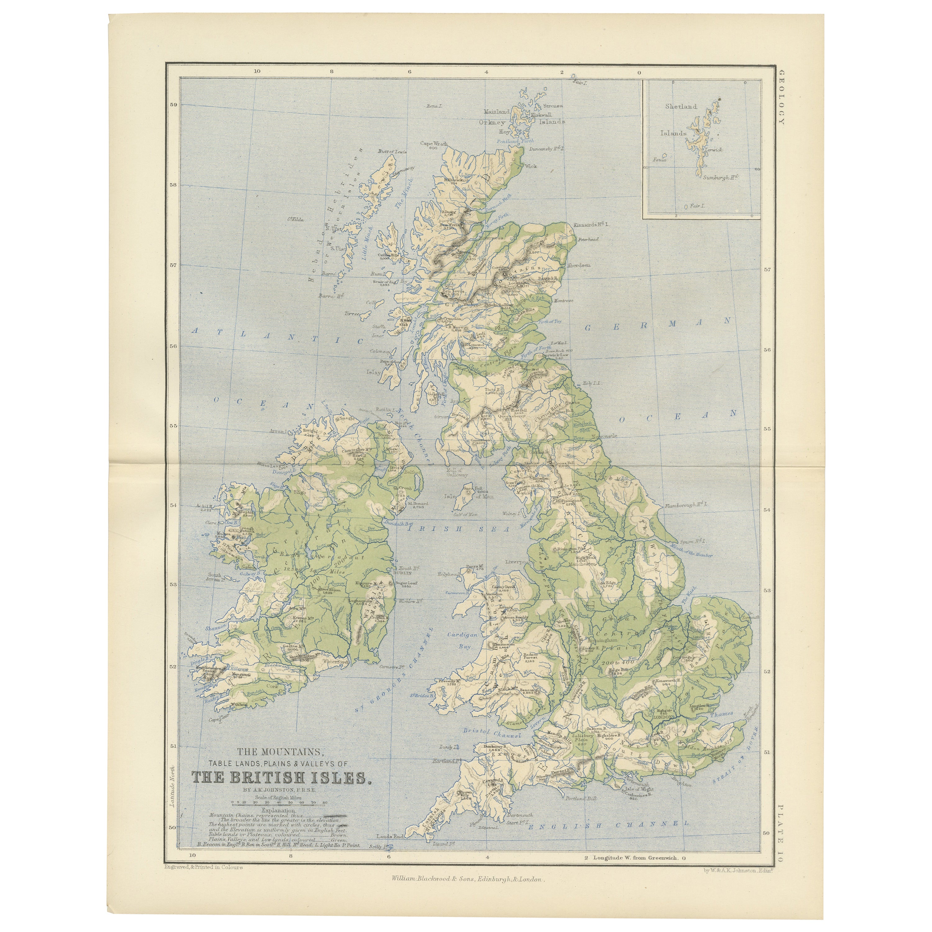
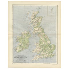
Geological Map of the British Isles by A.K. Johnston – Highlands & Valleys 1852
Geological Map of the British Isles by A.K. Johnston – Highlands & Valleys 1852
This antique topographic map titled "The Mountains, Table Lands, Plains & Valleys of the British Isle...
Kategorie
Antik, Mittleres 19. Jahrhundert, Schottisch, Drucke
Materialien
Papier
Das könnte Ihnen auch gefallen
Karte von Europa, 1844
Über 150 Jahre alte gestochene Europakarte von Olney aus dem Jahr 1844. Original Handfarbe. Zeigt Nordeuropa, Preußen und Deutschland.
Original antike Karte auf Papier auf einem...
Kategorie
1840er, Mehr Drucke
Materialien
Tinte, Wasserfarbe, Büttenpapier

Große Original-Antike Karte von Europa von Sidney Hall, 1847
Tolle Karte von Europa
Gezeichnet und gestochen von Sidney Hall
Stahlstich
Original-Farbumriss
Herausgegeben von A & C Black. 1847
Ungerahmt
Kostenloser Versand.
Kategorie
Antik, 1840er, Schottisch, Landkarten
Materialien
Papier

Originale antike Karte von Europa, Pfeilerschmied, 1820
Tolle Karte von Europa
Gezeichnet unter der Leitung von Arrowsmith.
Kupferstich.
Veröffentlicht von Longman, Hurst, Rees, Orme und Brown, 1820
Ungerahmt.
Kategorie
Antik, 1820er, Englisch, Landkarten
Materialien
Papier

Zweiteilige große handkolorierte Karte von Europa aus dem Jahr 1798
Von Thomas Kitchin
Karte von Europa, gedruckt auf zwei separaten Blättern aus A New Universal Atlas von Thomas Kitchin. Veröffentlicht in London von Laurie & Whittle, 1798. Originalstiche bei der Veröf...
Kategorie
1790er, Mehr Kunstobjekte
Materialien
Papier

1.476 € Angebotspreis
33 % Rabatt
1790 Thomas Stackhouse Map, mit dem Titel „Russia in Europe“, Ric.a004
1790 Thomas Stackhouse Karte, betitelt
"Russland in Europa"
Ric.a004
Stackhouse, Thomas
Russland in Europa [Karte]
London: T. Stackhouse, 1783. Karte. Mattierter handkolorie...
Kategorie
Antik, 17. Jahrhundert, Unbekannt, Landkarten
Materialien
Papier

Frankreich, Nordteil. Antike Atlas-Karte des Jahrhunderts
Der Jahrhundertatlas. Frankreich, Nordteil'.
Originale antike Karte, 1903.
Insetkarten von "Frankreich in den Provinzen" und "Paris und Umgebung".
Zentrale Falte wie ausgestellt. N...
Kategorie
Frühes 20. Jahrhundert, Viktorianisch, Mehr Drucke
Materialien
Lithografie
