Objekte ähnlich wie Geological Map of the British Isles by A.K. Johnston – Highlands & Valleys 1852


Möchten Sie mehr Bilder oder Videos?
Zusätzliche Bilder oder Videos von dem*der Anbieter*in anfordern
1 von 10
Geological Map of the British Isles by A.K. Johnston – Highlands & Valleys 1852
260 €pro Objekt|Einschließlich MwSt.
Menge
Versand
Angebot wird abgerufen …Das Versprechen von 1stDibs:
Authentizitätsgarantie,
Geld-Zurück-Garantie,
Stornierung innerhalb von 24 Stunden
Angaben zum Objekt
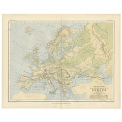
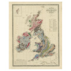
Geological Map of the British Isles by A.K. Johnston – Highlands & Valleys 1852
This antique topographic map titled "The Mountains, Table Lands, Plains & Valleys of the British Isles" was created by Alexander Keith Johnston and published in 1852 by William Blackwood & Sons in Edinburgh and London. It forms Plate 10 in Johnston’s landmark *Physical Atlas of Natural Phenomena*, one of the most influential works of thematic cartography of the 19th century.
The map offers a clear and scientific representation of the physical geography of Great Britain and Ireland, highlighting major mountain ranges, highlands, plains, river valleys, and tablelands using fine engraved detail and hand-applied color washes. Rather than depicting political boundaries, this plate focuses entirely on natural landforms and their elevations, providing insight into the geological character of the region.
Key physical features include the Highlands and Grampians of Scotland, the Pennines in northern England, the Cambrian Mountains of Wales, and the Cumbrian Fells. Ireland is shown with its central lowlands ringed by uplands, and an inset in the upper right corner details the Shetland Islands. Rivers such as the Thames, Shannon, Severn, and Clyde are precisely mapped, and lowland basins like those surrounding the Wash and the Fens are delicately shaded in green.
This map reflects the mid-19th century shift from political and colonial maps to scientific and thematic cartography. Alexander Keith Johnston (1804–1871), Geographer in Ordinary to Queen Victoria in Scotland, was one of the leading cartographic figures of his time. His *Physical Atlas* was the first to systematically visualize natural phenomena on a global scale through beautifully engraved and colored maps. This map is part of that series and stands as a testament to the combination of precision, clarity, and aesthetic quality in Victorian scientific publishing.
Highly collectible and still relevant today, this plate is perfect for historians, educators, or anyone with an interest in British natural history and geography.
Condition and framing tips:
Very good antique condition with minor age toning and a clean printed surface. Original centerfold as issued.
Ideal for framing in walnut, oak, or black wood with a warm ivory or cool grey mat to complement the greens and earth tones. A beautiful addition to a study, library, or historically inspired interior.
- Maße:Höhe: 34,5 cm (13,59 in)Breite: 27,4 cm (10,79 in)Tiefe: 0,2 mm (0,01 in)
- Materialien und Methoden:
- Herkunftsort:
- Zeitalter:
- Herstellungsjahr:1852
- Zustand:Very good condition. Light overall toning near the margins. The paper remains strong and well-preserved. Folding line as issued.
- Anbieterstandort:Langweer, NL
- Referenznummer:Anbieter*in: BG-13207-101stDibs: LU3054345388152
Anbieterinformationen
5,0
Anerkannte Anbieter*innen
Diese renommierten Anbieter*innen sind führend in der Branche und repräsentieren die höchste Klasse in Sachen Qualität und Design.
Platin-Anbieter*in
Premium-Anbieter*innen mit einer Bewertung über 4,7 und 24 Stunden Reaktionszeit
Gründungsjahr 2009
1stDibs-Anbieter*in seit 2017
2.508 Verkäufe auf 1stDibs
Typische Antwortzeit: <1 Stunde
- VersandAngebot wird abgerufen …Versand von: Langweer, Niederlande
- Rückgabebedingungen
Einige Inhalte dieser Seite wurden automatisch übersetzt. Daher kann 1stDibs nicht die Richtigkeit der Übersetzungen garantieren. Englisch ist die Standardsprache dieser Website.
Authentizitätsgarantie
Im unwahrscheinlichen Fall eines Problems mit der Echtheit eines Objekts kontaktieren Sie uns bitte innerhalb von 1 Jahr für eine volle Rückerstattung. DetailsGeld-Zurück-Garantie
Wenn Ihr Objekt nicht der Beschreibung entspricht, beim Transport beschädigt wurde oder nicht ankommt, kontaktieren Sie uns bitte innerhalb von 7 Tagen für eine vollständige Rückerstattung. DetailsStornierung innerhalb von 24 Stunden
Sie können Ihren Kauf jederzeit innerhalb von 24 Stunden stornieren, ohne jegliche Gründe dafür angeben zu müssen.Geprüfte Anbieter*innen
Unsere Anbieter*innen unterliegen strengen Dienstleistungs- und Qualitätsstandards, wodurch wir die Seriosität unserer Angebote gewährleisten können.Preisgarantie
Wenn Sie feststellen, dass ein*e Anbieter*in dasselbe Objekt anderswo zu einem niedrigeren Preis anbietet, werden wir den Preis entsprechend anpassen.Zuverlässige weltweite Lieferung
Unsere erstklassigen Versandunternehmen bieten spezielle Versandoptionen weltweit, einschließlich individueller Lieferung.Mehr von diesem*dieser Anbieter*in
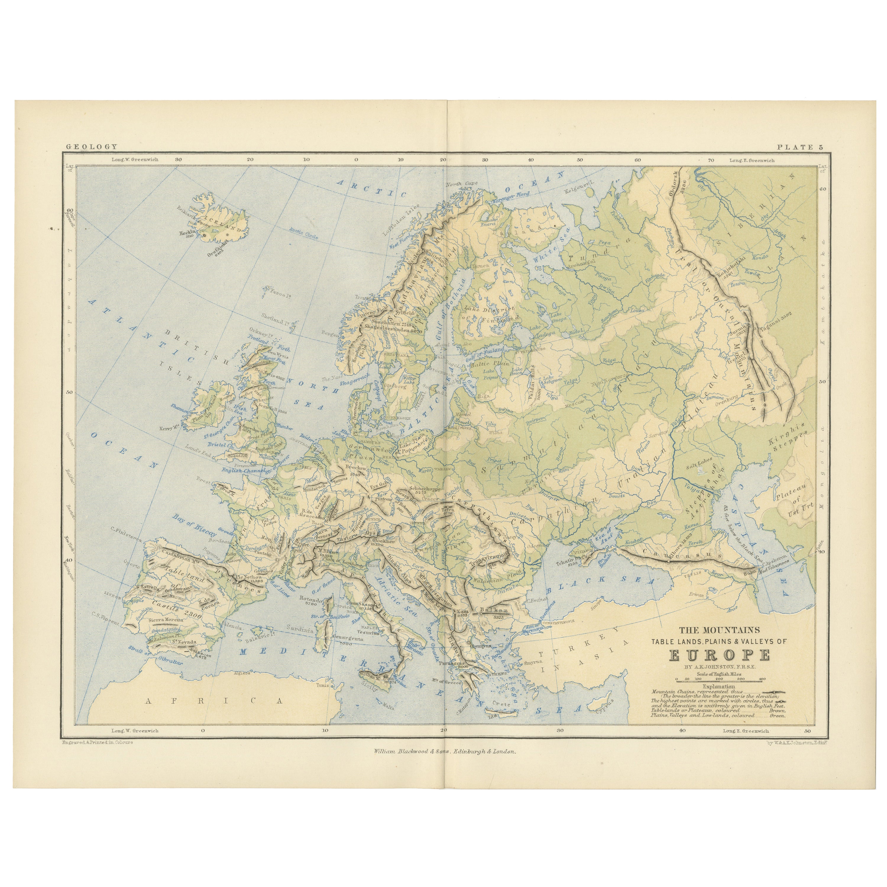
Alle anzeigenGeological Map of Europe by A.K. Johnston – Mountains and Valleys 1852
Geological Map of Europe by A.K. Johnston – Mountains and Valleys 1852
This elegant 1852 map titled "The Mountains, Table Lands, Plains & Valleys of Europe" was designed by the accl...
Kategorie
Antik, Mittleres 19. Jahrhundert, Schottisch, Drucke
Materialien
Papier
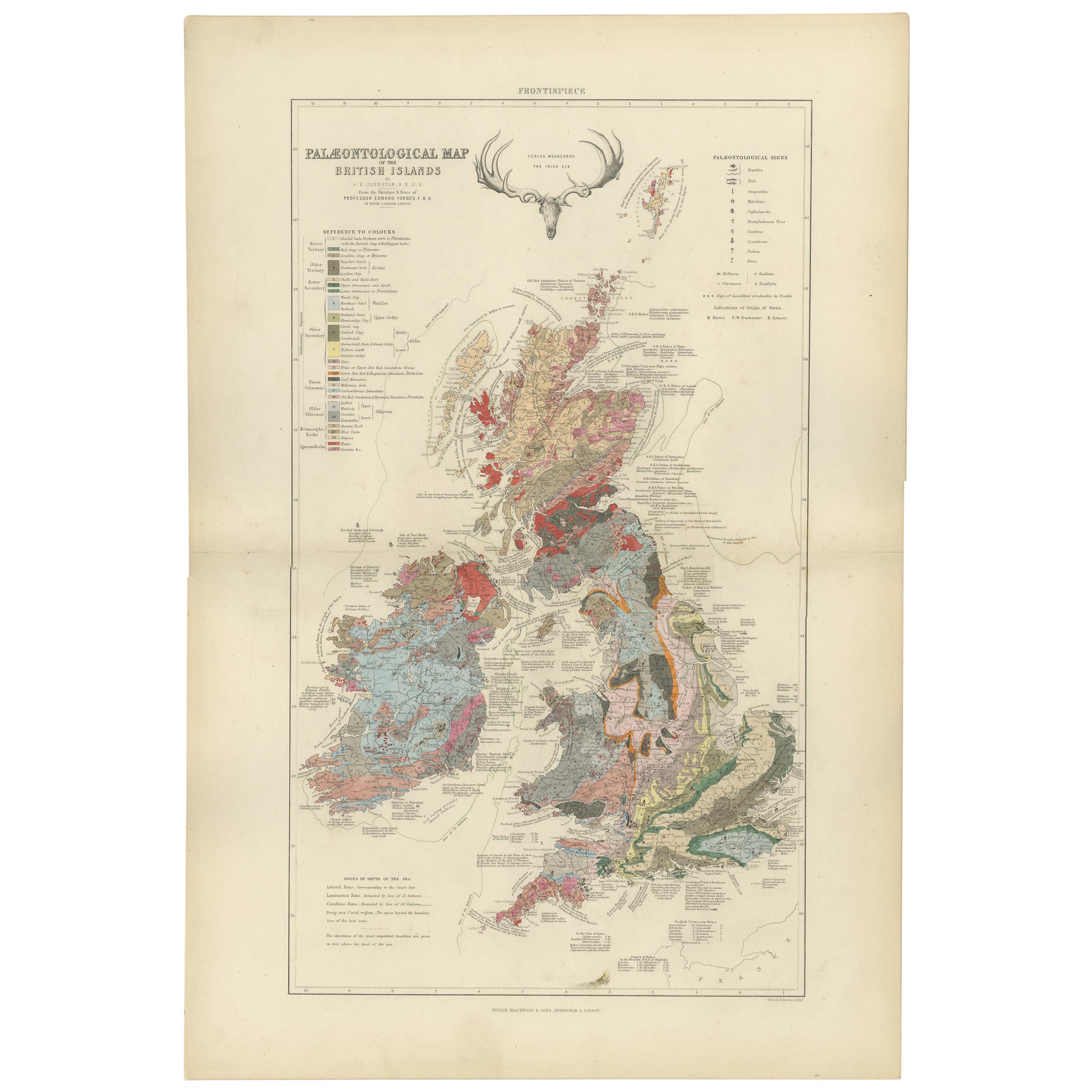
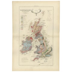
Antike antike Karte der Palaeontologie der britischen Inseln von Johnston aus dem Jahr 1850
Antike Karte mit dem Titel 'Paläontologische Karte der Britischen Inseln'. Originale antike Karte, die die Paläontologie der Britischen Inseln zeigt. Diese Karte stammt aus "The Phys...
Kategorie
Antik, Mittleres 19. Jahrhundert, Landkarten
Materialien
Papier
360 € Angebotspreis
20 % Rabatt
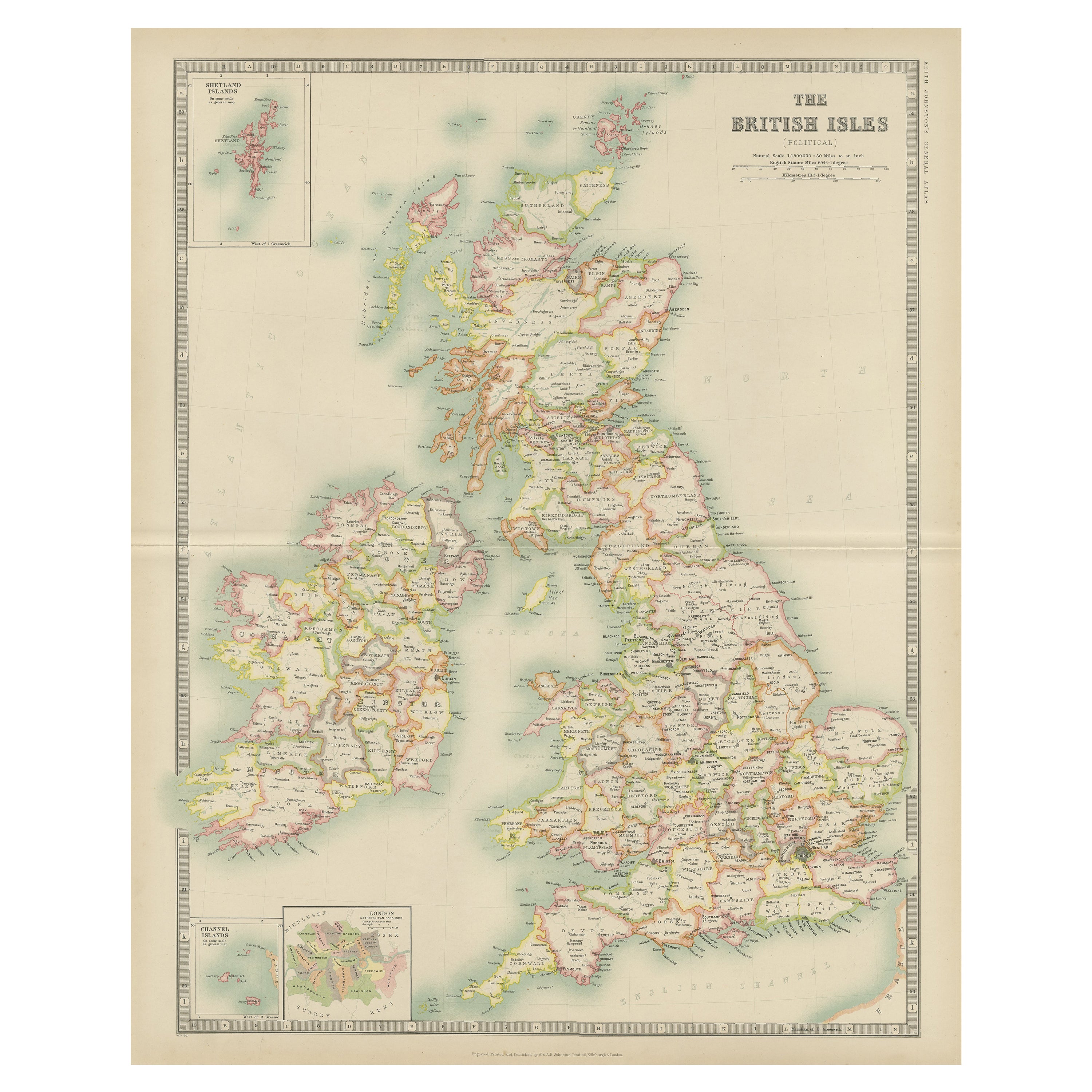
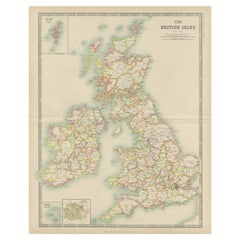
Antike Karte der britischen Inseln von Johnston „1909“
Antike Karte mit dem Titel 'Die Britischen Inseln'. Original antike Karte der Britischen Inseln. Mit beigefügten Karten der Shetland-Inseln, der Chanel-Inseln und von London. Diese K...
Kategorie
Frühes 20. Jahrhundert, Landkarten
Materialien
Papier
200 € Angebotspreis
20 % Rabatt
Unter der Oberfläche: James Wylds geologische Karte der britischen Inseln von 1844
Diese hervorragende geologische Originalkarte des Vereinigten Königreichs von Großbritannien und Irland von James Wyld aus dem Jahr 1844 ist ein bemerkenswertes viktorianisches Kunst...
Kategorie
Antik, 1840er, Landkarten
Materialien
Papier
720 € Angebotspreis
20 % Rabatt
Antike Karte der britischen Inseln von Balbi '1847'
Antike Karte mit dem Titel 'Iles Britanniques'. Original antike Karte der Britischen Inseln. Diese Karte stammt aus "Abrégé de Géographie (..)" von Adrien Balbi. Veröffentlicht 1847.
Kategorie
Antik, Mittleres 19. Jahrhundert, Landkarten
Materialien
Papier

120 € Angebotspreis
20 % Rabatt
Antike Karte von England und Wales „North“ von A.K. Johnston, 1865
Antike Karte mit dem Titel 'England und Wales (Nordblatt)'. Diese Karte stammt aus dem "Royal Atlas of Modern Geography" von Alexander Keith Johnston. Herausgegeben von William Black...
Kategorie
Antik, Mittleres 19. Jahrhundert, Landkarten
Materialien
Papier

220 € Angebotspreis
20 % Rabatt
Das könnte Ihnen auch gefallen
Originale antike Karte von Schottland von Dower, ca. 1835
Schöne Karte von Schottland
Gezeichnet und gestochen von J. Dower
Herausgegeben von Orr & Smith. C.1835
Ungerahmt.
Kostenloser Versand
Kategorie
Antik, 1830er, Englisch, Landkarten
Materialien
Papier

England und Wales, teilweise in Nordengland. Antike Atlas-Vintage-Karte
Der Jahrhundertatlas. England und Wales, Nordteil".
Originale antike Karte, 1903.
Zentrale Falte wie ausgestellt. Name und Nummer der Karte sind auf der Rückseite aufgedruckt.
Blat...
Kategorie
Frühes 20. Jahrhundert, Viktorianisch, Mehr Drucke
Materialien
Lithografie

Große Original-Vintage-Karte des Vereinigten Königreichs, um 1920
Große Karte des Vereinigten Königreichs
Ungerahmt
Original Farbe
Von John Bartholomew und Co. Geographisches Institut Edinburgh
Veröffentlicht, ca. 1920
Kostenloser Ve...
Kategorie
Vintage, 1920er, Britisch, Landkarten
Materialien
Papier

England, Schottland und Irland: Eine handkolorierte Karte von Großbritannien von Tirion
Von Isaak Tirion
Dies ist eine handkolorierte doppelseitige Kupferstichkarte von Großbritannien mit dem Titel "Nieuwe Kaart van de Eilanden van Groot Britta...
Kategorie
Antik, Mitte des 18. Jahrhunderts, Niederländisch, Landkarten
Materialien
Papier

Old Horizontal Map of England
Von Tasso
ST/520 - Alte seltene italienische Karte von England, datiert 1826-1827 - von Girolamo Tasso, Herausgeber in Venedig, für den Atlas von M.r Le-Sage.
Kategorie
Antik, Frühes 19. Jahrhundert, Italienisch, Sonstiges, Drucke
Materialien
Papier

England und die britischen Inseln: Eine große handkolorierte Karte aus dem 17. Jahrhundert von de Wit
Von Frederick de Wit
Dies ist eine große handkolorierte Karte von England und den Britischen Inseln aus dem 17. Jahrhundert von Frederick de Wit mit dem Titel "Accuratissima Angliæ Regni et Walliæ Princi...
Kategorie
Spätes 17. Jahrhundert, Sonstige Kunststile, Landschaftsdrucke
Materialien
Gravur
