Artículos similares a Botanical Map by A.K. Johnston – Global Plant Distribution Chart 1852


¿Quieres más imágenes o vídeos?
Solicita imágenes o vídeos adicionales al vendedor
1 de 10
Botanical Map by A.K. Johnston – Global Plant Distribution Chart 1852
260 €por artículo|IVA incluido
Cantidad
Envío
Recuperando presupuesto…La promesa de 1stDibs
Garantía de autenticidad,
Garantía de devolución de dinero,
Cancelación dentro de las 24 horas
Acerca del artículo
Botanical Map by A.K. Johnston – Global Plant Distribution Chart 1852
This remarkable antique chart titled "The Distribution of the Most Important Trees, Shrubs, Grains, & Fruits According to Zones of Climate & Moisture" was created by Alexander Keith Johnston and published in 1852 by William Blackwood & Sons, Edinburgh and London. It is Plate 15 from Johnston’s revolutionary *Physical Atlas of Natural Phenomena*, a foundational work in scientific cartography.
This thematic map combines botanical geography and climatology to illustrate how vegetation and agricultural crops are distributed across the globe according to climatic zones and moisture levels. Zones such as the "Climate of the Tropics," "European & Tropical," and "Northern Zone of Perpetual Ice and Snow" are color-coded and labeled with the dominant plants, fruits, or grains associated with each area.
The map meticulously annotates where particular species grow best: bananas and sugarcane in equatorial regions, wheat and apples in temperate zones, palms and spice trees in the tropics, and mosses and berries in the Arctic. The influence of rainfall and elevation is also emphasized, providing a multidimensional understanding of global botanical ecology as understood in the 19th century.
Beneath the main map is a stunning cross-sectional diagram titled "Distribution of Plants in a Vertical Direction," illustrating mountain ecosystems from the Rocky Mountains and Andes to the Himalayas and Alps. As the elevation rises, the vegetation zones change—from tropical palms at the base to alpine mosses and lichens near the peaks—offering a visual summary of how altitude affects plant distribution as dramatically as latitude.
Alexander Keith Johnston (1804–1871), a leading figure in Victorian science and cartography, was Geographer in Ordinary to Queen Victoria in Scotland. His work revolutionized the use of maps to present scientific data, and his *Physical Atlas* is still admired for its clarity, elegance, and educational ambition.
This chart is a must-have for collectors of botanical history, early climatology, or decorative scientific illustrations. Its blend of empirical data and visual storytelling is both informative and visually compelling.
Condition and framing tips:
Very good antique condition with minor age toning and a clean printed surface. A striking plate for display, best framed in walnut or gold with a warm ivory mat to highlight the earthy tones and detailed illustrations. Ideal for a library, conservatory, or academic interior.
- Dimensiones:Altura: 27,4 cm (10,79 in)Anchura: 34,5 cm (13,59 in)Profundidad: 0,2 mm (0,01 in)
- Materiales y técnicas:
- Lugar de origen:
- Época:
- Fecha de fabricación:1852
- Estado:Very good condition. Light overall toning near the margins. The paper remains strong and well-preserved. Folding line as issued.
- Ubicación del vendedor:Langweer, NL
- Número de referencia:Vendedor: BG-13207-151stDibs: LU3054345393502
Sobre el vendedor
5,0
Vendedor reconocido
Estos prestigiosos vendedores son líderes del sector y representan el escalón más alto en cuanto a calidad y diseño de artículos.
Vendedor Platino
Vendedores premium con una calificación de +4,7 y tiempos de respuesta de 24 horas
Establecido en 2009
Vendedor de 1stDibs desde 2017
2493 ventas en 1stDibs
Tiempo de respuesta usual: <1 hora
- EnvíoRecuperando presupuesto…Envío desde: Langweer, Países Bajos
- Política de devolución
Partes de esta página se han traducido automáticamente. 1stDibs no puede garantizar la exactitud de las traducciones. El inglés es el idioma predeterminado de este sitio web.
Garantía de autenticidad
En el improbable caso de que haya algún problema con la autenticidad de un artículo, ponte en contacto con nosotros en un plazo de 1 año para recibir un reembolso total. DetallesGarantía de devolución de dinero
Si tu artículo no es como se describe, sufre daños durante el transporte o no llega, ponte en contacto con nosotros en un plazo de 7 días para recibir un reembolso total. DetallesCancelación dentro de las 24 horas
Tienes un período de gracia de 24 horas para reconsiderar tu compra, sin preguntas.Vendedores profesionales aprobados
Nuestros vendedores de primera clase deben cumplir estrictos estándares de servicio para mantener la integridad de nuestros anuncios.Garantía de igualación de precios
Si encuentras que un vendedor publicó el mismo artículo por un precio menor en otro lado, igualaremos ese precio.Entrega global de confianza
Nuestra red de transporte de primera ofrece opciones de envío especializado en todo el mundo, que incluye envío personalizado.Más de este vendedor
Ver todoMapa antiguo que muestra la distribución de las plantas por Johnston, '1850
Mapa antiguo titulado "Distribución geográfica de las plantas". Mapa antiguo original que muestra la distribución de las plantas. Este mapa procede de "El Atlas Físico de los Fenómen...
Categoría
Antiguo, Mediados del siglo XIX, Mapas
Materiales
Papel

160 € Precio de venta
Descuento del 20 %
Mapa antiguo del mundo con la distribución de plantas y minerales, 1872
Mapa antiguo titulado 'El mundo de Johnson mostrando la distribución de los árboles forestales característicos (..)'. Mapamundi original que muestra la distribución de plantas y mine...
Categoría
Antiguo, Fines del siglo XIX, Mapas
Materiales
Papel

160 € Precio de venta
Descuento del 20 %
Mapa antiguo que muestra la distribución de las plantas por Johnston '1850
Mapa antiguo titulado "Plantas geográficas que sirven de alimento al hombre". Mapa antiguo original que muestra la distribución de las plantas. Este mapa procede de "El Atlas Físico ...
Categoría
Antiguo, Mediados del siglo XIX, Mapas
Materiales
Papel
160 € Precio de venta
Descuento del 20 %
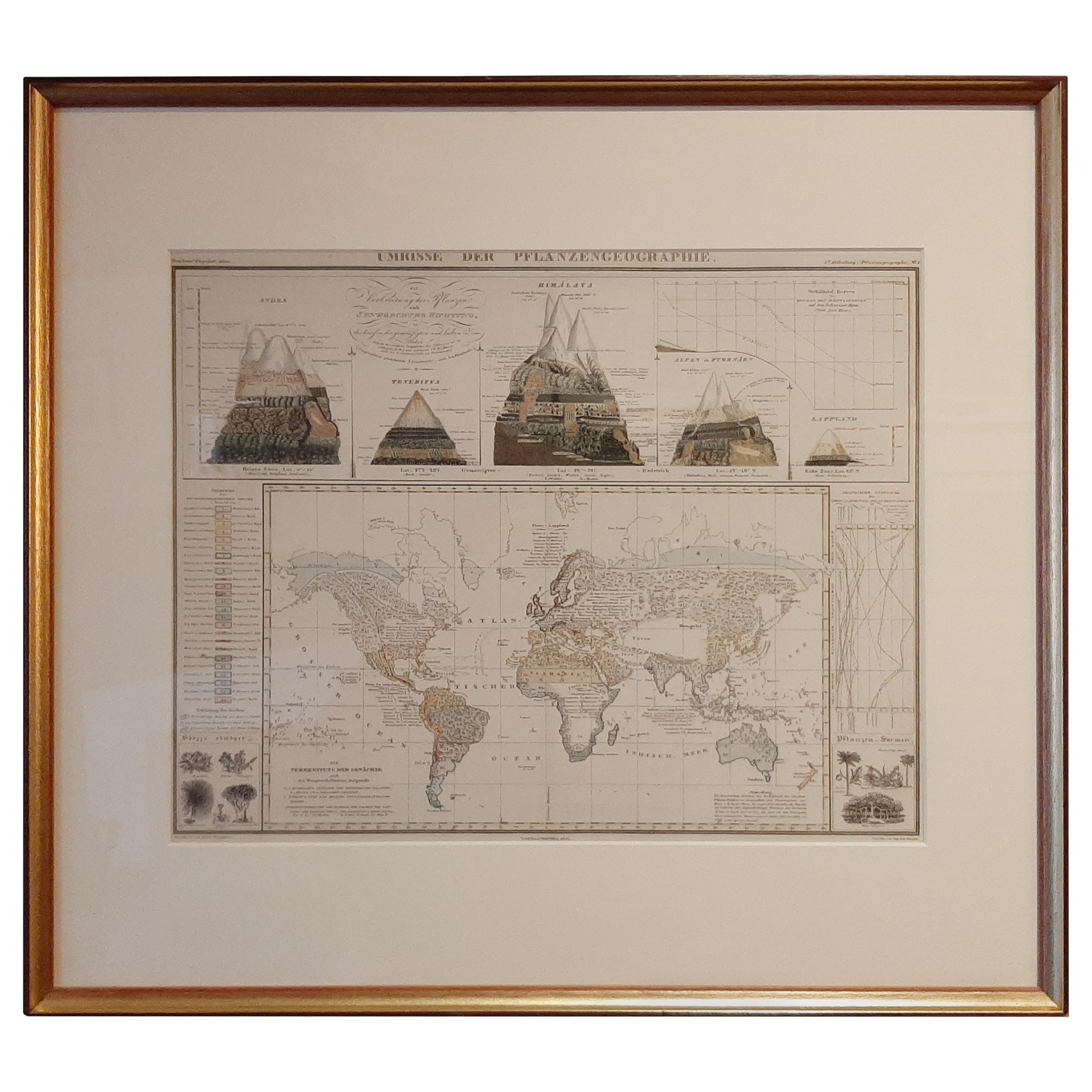
Mapa Antiguo de la Distribución de la Vegetación en el Mundo '1851
Mapa antiguo titulado "Umrisse der Pflanzengeographie". Mapa antiguo original que muestra la distribución de la vegetación en todo el mundo. Cinco dibujos sobre el mapa muestran la v...
Categoría
Antiguo, Mediados del siglo XIX, Mapas
Materiales
Papel
600 € Precio de venta
Descuento del 20 %
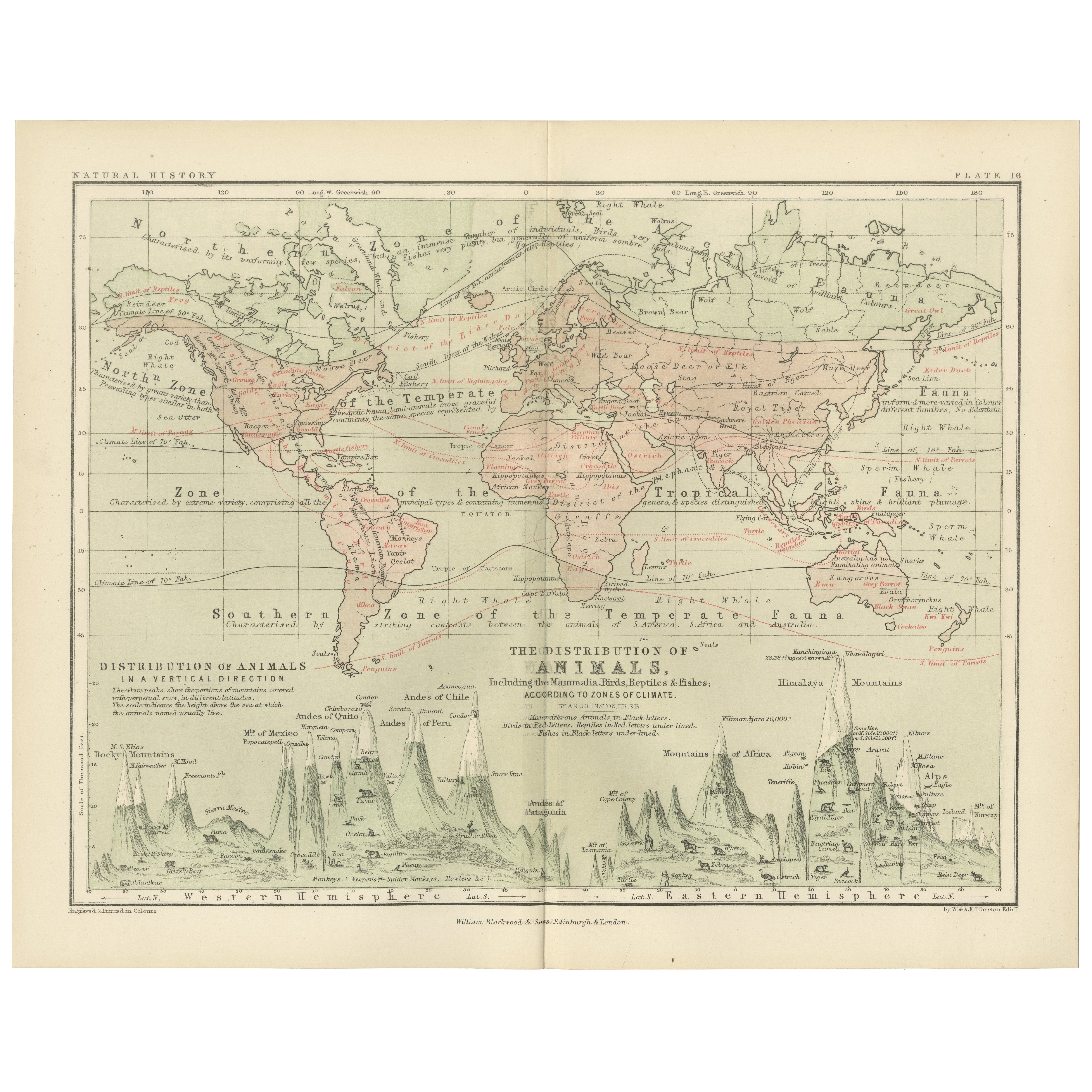
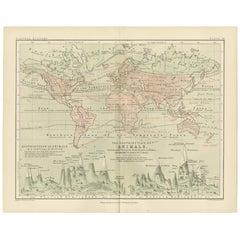
Animal Distribution Map by A.K. Johnston – Fauna by Climate Zones 1852
Animal Distribution Map by A.K. Johnston – Fauna by Climate Zones 1852
This beautifully engraved chart titled "The Distribution of Animals Including the Mammalia, Birds, Reptiles & ...
Categoría
Antiguo, Mediados del siglo XIX, Escocés, Impresiones
Materiales
Papel
Mapa antiguo de El mundo en hemisferios por W. G. Blackie, 1859
Mapa antiguo titulado "El mundo en hemisferios con otras proyecciones". Mapa antiguo original de El Mundo. Este mapa procede del "Atlas Imperial de Geografía Moderna". Publicado por ...
Categoría
Antiguo, Mediados del siglo XIX, Mapas
Materiales
Papel

245 € Precio de venta
Descuento del 30 %
También te puede gustar
Mapa Antiguo Original del Mundo por Dower, circa 1835
Bonito mapa del Mundo
Dibujado y grabado por J.Dower
Publicado por Orr & Smith. C.1835
Sin enmarcar.
Envío gratuito
Categoría
Antiguo, Década de 1830, Inglés, Mapas
Materiales
Papel

1864 Planisferio ilustrado original - Mapamundi - Geografía
Sumérgete en el viaje épico del pasado con el Planisferio Histórico Ilustrado de 1864 de Charpentier! 🗺️ Este tesoro cartográfico te transporta a través de los entresijos de la hist...
Categoría
Década de 1860, Impresiones y múltiplos
Materiales
Lino, Litografía, Papel

Antiguo mapa original del mundo de Thomas Clerk, 1817
Gran mapa de los hemisferios oriental y occidental
En 2 hojas
Grabado en cobre
Dibujado y grabado por Thomas Clerk, Edimburgo.
Publicado por Mackenzie And Dent, 1817
S...
Categoría
Antiguo, Década de 1810, Inglés, Mapas
Materiales
Papel

Mapa original antiguo del hemisferio occidental por Dower, hacia 1835
Bonito mapa del Hemisferio Occidental
Dibujado y grabado por J.Dower
Publicado por Orr & Smith. C.1835
Sin enmarcar.
Envío gratuito
Categoría
Antiguo, Década de 1830, Inglés, Mapas
Materiales
Papel

Gran Mapa Antiguo Original del Mundo, Fullarton, C.1870
Gran mapa del Mundo. Mostrando ambos hemisferios
Del célebre Atlas Real Ilustrado
Litografía. Color original.
Publicado por Fullarton, Edimburgo, C.1870
Sin enmarcar.
Reparació...
Categoría
Antiguo, Década de 1870, Escocés, Mapas
Materiales
Papel

John Thomson (1777-1840) - Grabado de mapa de 1830, Carta del Mundo
Por John Thomson
Fino mapa grabado del mundo en proyección de Mercator, de la segunda edición del "Nuevo Atlas General" de John Thomson, publicado en 1830. Sobre el papel.
Categoría
principios del siglo XIX, Más impresiones
Materiales
Grabado
275 € Precio de venta
Descuento del 20 %