Artículos similares a Climatological Map by A.K. Johnston – Global Temperatures Chart 1852


¿Quieres más imágenes o vídeos?
Solicita imágenes o vídeos adicionales al vendedor
1 de 10
Climatological Map by A.K. Johnston – Global Temperatures Chart 1852
260 €por artículo|IVA incluido
Cantidad
Envío
Recuperando presupuesto…La promesa de 1stDibs
Garantía de autenticidad,
Garantía de devolución de dinero,
Cancelación dentro de las 24 horas
Acerca del artículo
Climatological Map by A.K. Johnston – Global Temperatures Chart 1852
This exceptional antique map titled "Climatological Chart Showing by Lines & Figures the Mean Annual Temperature of the Principal Places on the Globe" was created by Alexander Keith Johnston and published in 1852 by William Blackwood & Sons of Edinburgh and London. It was issued as Plate 12 in Johnston’s landmark *Physical Atlas of Natural Phenomena*, a pioneering 19th-century atlas that brought scientific visualization into wide public use.
This map is an early attempt to systematically present global climate data. It displays mean annual temperatures across the world using isothermal lines (red and blue) that connect locations of equal average temperature. The isotherms are drawn with precise geographic accuracy and overlaid with data from major cities and meteorological stations. The red lines represent mean annual temperatures at various latitudes, while blue lines denote temperature during winter.
The chart also includes two detailed insets. One shows the British Isles with a focus on summer and winter mean temperatures by city and station, while the second presents similar data for Central Europe. These regional maps offer insight into 19th-century meteorological science and the importance of regional climate comparisons in early climatology.
Johnston’s meticulous work combines data with elegant cartographic design. His maps are not only valuable scientific tools but also highly decorative. Johnston (1804–1871), Geographer in Ordinary to Queen Victoria in Scotland, was instrumental in the development of thematic cartography. His *Physical Atlas* remains one of the most influential scientific atlases ever published, appreciated for its beauty and clarity as much as for its content.
This plate is particularly interesting for its foresight in climate science and as an early visual reference to global temperature distribution—concepts that underpin today’s environmental studies and climate models.
Condition and framing tips:
Good condition with light age toning and minor wear at the margins. Image field clean and sharp. Frame in matte black or dark walnut with a cream or ivory mat to highlight the fine engraved lines and soft red and blue temperature curves. Ideal for scholars, educators, and interiors with a natural history or scientific theme.
- Dimensiones:Altura: 34,5 cm (13,59 in)Anchura: 27,4 cm (10,79 in)Profundidad: 0,2 mm (0,01 in)
- Materiales y técnicas:
- Lugar de origen:
- Época:
- Fecha de fabricación:1852
- Estado:Very good condition. Light overall toning near the margins. The paper remains strong and well-preserved. Folding line as issued.
- Ubicación del vendedor:Langweer, NL
- Número de referencia:Vendedor: BG-13207-121stDibs: LU3054345393422
Sobre el vendedor
5,0
Vendedor reconocido
Estos prestigiosos vendedores son líderes del sector y representan el escalón más alto en cuanto a calidad y diseño de artículos.
Vendedor Platino
Vendedores premium con una calificación de +4,7 y tiempos de respuesta de 24 horas
Establecido en 2009
Vendedor de 1stDibs desde 2017
2493 ventas en 1stDibs
Tiempo de respuesta usual: <1 hora
- EnvíoRecuperando presupuesto…Envío desde: Langweer, Países Bajos
- Política de devolución
Partes de esta página se han traducido automáticamente. 1stDibs no puede garantizar la exactitud de las traducciones. El inglés es el idioma predeterminado de este sitio web.
Garantía de autenticidad
En el improbable caso de que haya algún problema con la autenticidad de un artículo, ponte en contacto con nosotros en un plazo de 1 año para recibir un reembolso total. DetallesGarantía de devolución de dinero
Si tu artículo no es como se describe, sufre daños durante el transporte o no llega, ponte en contacto con nosotros en un plazo de 7 días para recibir un reembolso total. DetallesCancelación dentro de las 24 horas
Tienes un período de gracia de 24 horas para reconsiderar tu compra, sin preguntas.Vendedores profesionales aprobados
Nuestros vendedores de primera clase deben cumplir estrictos estándares de servicio para mantener la integridad de nuestros anuncios.Garantía de igualación de precios
Si encuentras que un vendedor publicó el mismo artículo por un precio menor en otro lado, igualaremos ese precio.Entrega global de confianza
Nuestra red de transporte de primera ofrece opciones de envío especializado en todo el mundo, que incluye envío personalizado.Más de este vendedor
Ver todoWind and Hurricane Map by A.K. Johnston – Meteorological Chart 1852
Wind and Hurricane Map by A.K. Johnston – Meteorological Chart 1852
This scientifically significant 1852 map titled "The Distribution of the Constant, Periodical & Variable Winds Ov...
Categoría
Antiguo, Mediados del siglo XIX, Escocés, Impresiones
Materiales
Papel

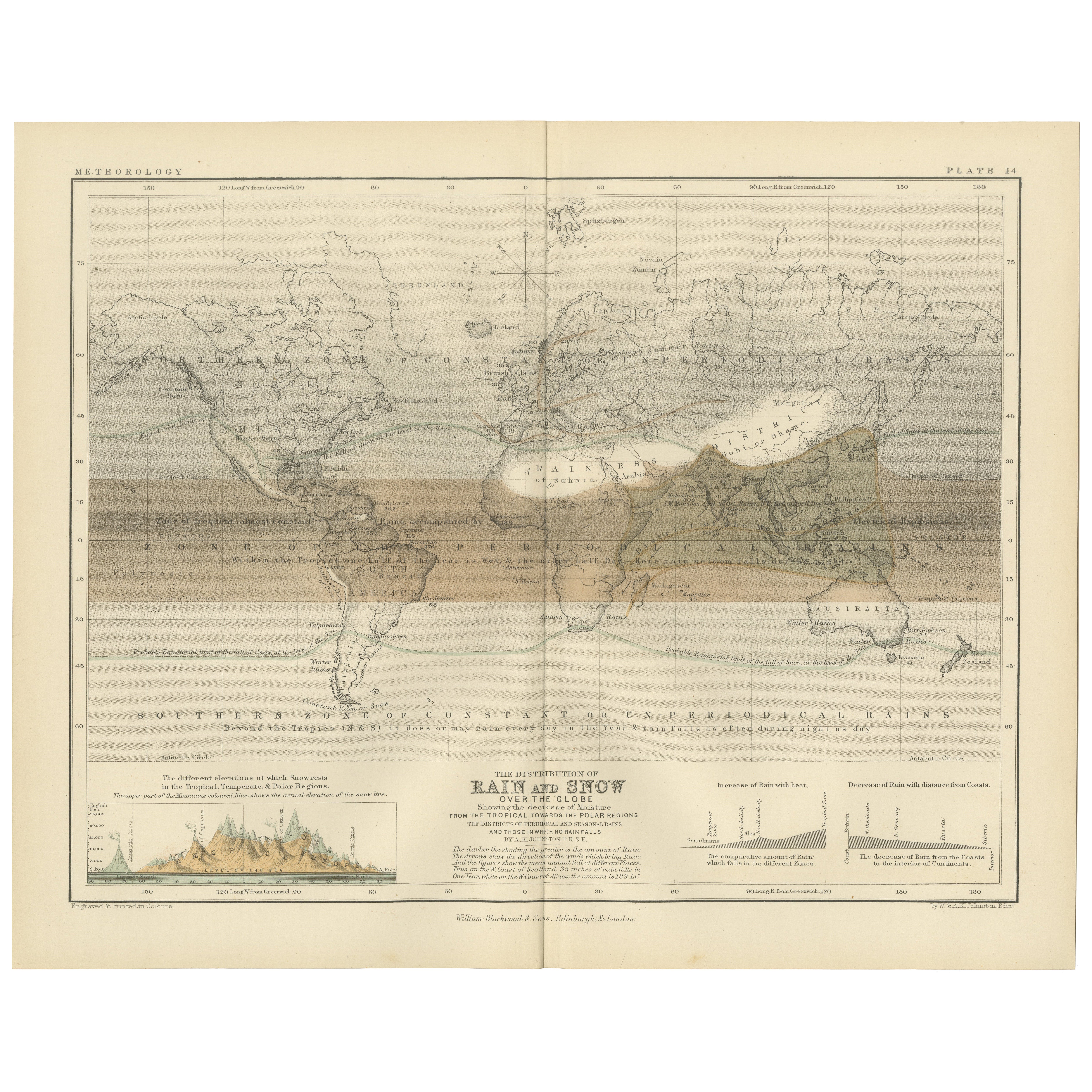
Rain and Snow Map by A.K. Johnston – Global Precipitation Chart 1852
Rain and Snow Map by A.K. Johnston – Global Precipitation Chart 1852
This antique meteorological chart titled "The Distribution of Rain and Snow over the Globe" was created by Alexa...
Categoría
Antiguo, Mediados del siglo XIX, Escocés, Impresiones
Materiales
Papel
Mapa antiguo que muestra las líneas isotérmicas en todo el mundo por Johnston '1850
Mapa antiguo titulado "Sistema de líneas isotérmicas de Humboldt". Mapa original antiguo que muestra las líneas de isoterma en todo el mundo. Este mapa procede de "El Atlas Físico de...
Categoría
Antiguo, Mediados del siglo XIX, Mapas
Materiales
Papel

160 € Precio de venta
Descuento del 20 %
Mapa antiguo del mundo con la distribución de plantas y minerales, 1872
Mapa antiguo titulado 'El mundo de Johnson mostrando la distribución de los árboles forestales característicos (..)'. Mapamundi original que muestra la distribución de plantas y mine...
Categoría
Antiguo, Fines del siglo XIX, Mapas
Materiales
Papel

160 € Precio de venta
Descuento del 20 %
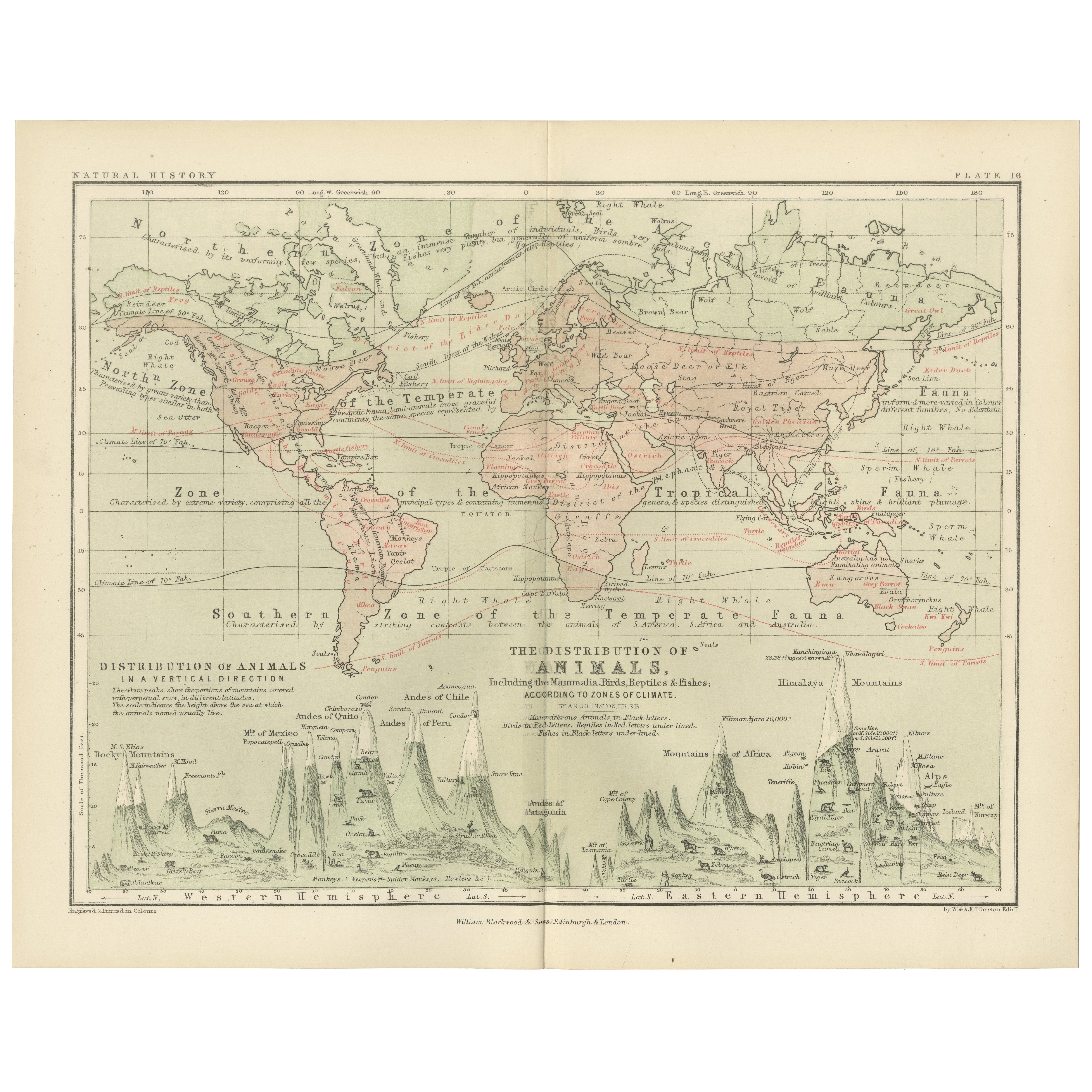
Animal Distribution Map by A.K. Johnston – Fauna by Climate Zones 1852
Animal Distribution Map by A.K. Johnston – Fauna by Climate Zones 1852
This beautifully engraved chart titled "The Distribution of Animals Including the Mammalia, Birds, Reptiles & ...
Categoría
Antiguo, Mediados del siglo XIX, Escocés, Impresiones
Materiales
Papel
Mapa antiguo que muestra las corrientes oceánicas y la temperatura del aire, '1872
Dos mapas en una hoja titulados "Las corrientes oceánicas de Johnson (..)" y "El mundo de Johnson mostrando la distribución de la temperatura del aire". Mapamundi original que muestr...
Categoría
Antiguo, Fines del siglo XIX, Mapas
Materiales
Papel

280 € Precio de venta
Descuento del 20 %
También te puede gustar
Antiguo mapa original del mundo de Thomas Clerk, 1817
Gran mapa de los hemisferios oriental y occidental
En 2 hojas
Grabado en cobre
Dibujado y grabado por Thomas Clerk, Edimburgo.
Publicado por Mackenzie And Dent, 1817
S...
Categoría
Antiguo, Década de 1810, Inglés, Mapas
Materiales
Papel

Mapa Antiguo Original del Hemisferio Oriental por Dower, hacia 1835
Bonito mapa del hemisferio oriental
Dibujado y grabado por J.Dower
Publicado por Orr & Smith. C.1835
Sin enmarcar.
Envío gratuito
Categoría
Antiguo, Década de 1830, Inglés, Mapas
Materiales
Papel

Hemisferio del Nuevo Continente - Mapa antiguo de J.G. J. Heck - 1834.
Por Johann Georg Heck
Hemisferio del Nuevo Continente es una obra de arte realizada hacia 1760 por Johann Georg Heck
Impresión original en color.
Buen estado, salvo por el amarilleamiento del papel y l...
Categoría
Década de 1830, Moderno, Impresiones figurativas
Materiales
Grabado químico

Mapa Antiguo Original del Mundo por Dower, circa 1835
Bonito mapa del Mundo
Dibujado y grabado por J.Dower
Publicado por Orr & Smith. C.1835
Sin enmarcar.
Envío gratuito
Categoría
Antiguo, Década de 1830, Inglés, Mapas
Materiales
Papel

Mapa original antiguo del hemisferio occidental por Dower, hacia 1835
Bonito mapa del Hemisferio Occidental
Dibujado y grabado por J.Dower
Publicado por Orr & Smith. C.1835
Sin enmarcar.
Envío gratuito
Categoría
Antiguo, Década de 1830, Inglés, Mapas
Materiales
Papel

Mapa antiguo del Imperio Británico - Mapa antiguo de Karl Spruner - 1760 ca.
Por Karl Spruner von Merz
Antiguo mapa del Imperio Británico es una obra de arte realizada hacia 1760 por Karl Spruner.
Grabado original coloreado a mano.
Buen estado, salvo por el amarilleamiento del papel...
Categoría
Década de 1760, Moderno, Impresiones figurativas
Materiales
Grabado químico
