Artículos similares a Ethnographic Map of the World by A.K. Johnston – Races of Man Chart 1852


¿Quieres más imágenes o vídeos?
Solicita imágenes o vídeos adicionales al vendedor
1 de 10
Ethnographic Map of the World by A.K. Johnston – Races of Man Chart 1852
260 €por artículo|IVA incluido
Cantidad
Envío
Recuperando presupuesto…La promesa de 1stDibs
Garantía de autenticidad,
Garantía de devolución de dinero,
Cancelación dentro de las 24 horas
Acerca del artículo
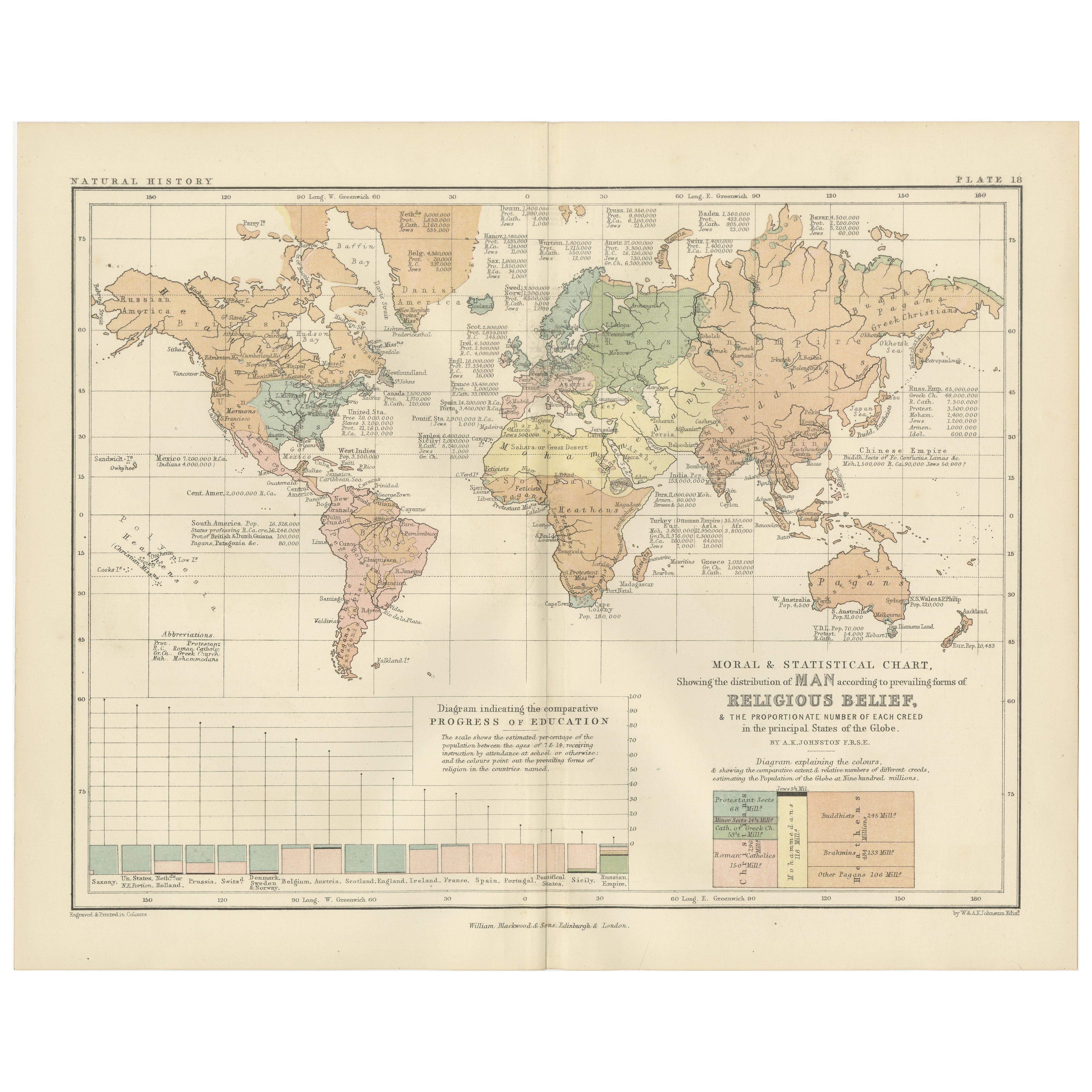
Ethnographic Map of the World by A.K. Johnston – Races of Man Chart 1852
This antique map titled "Ethnographic Map of the World Showing the Present Distribution of the Leading Races of Man" was created by Alexander Keith Johnston and published in 1852 by William Blackwood & Sons in Edinburgh and London. Issued as Plate 17 in Johnston’s *Physical Atlas of Natural Phenomena*, this map reflects 19th-century efforts to visualize human diversity across the globe through early ethnographic theory.
The map categorizes the world's populations into ten generalized racial and cultural groupings, each represented in distinct pastel shades. These include classifications such as Indo-European, Semitic, Negro, Mongolian, Malay, American, and others based on contemporary (now outdated) 19th-century anthropological thought. The regions of distribution are shaded accordingly, spanning continents from the Arctic Circle to the islands of the Pacific.
A large inset map at the bottom right provides a focused view of Europe, showing greater detail in the distribution of groups such as Slavonic, Germanic, Celtic, Basque, and Finnic peoples. Alongside it is a striking profile diagram illustrating the elevation of Earth's landmasses, tying physical geography to patterns of human settlement.
This map, like many from the mid-19th century, combines the empirical ambitions of early anthropology with the visual clarity of scientific cartography. While its categories and terminology are now considered outdated and oversimplified, the chart is an important artifact from the history of ethnography and reflects the European scientific worldview of the time.
Alexander Keith Johnston (1804–1871), one of the most respected geographers of his age, created the *Physical Atlas* as an educational tool to help readers understand the natural world and its human patterns through maps. His work remains a landmark in the development of thematic cartography.
This plate is a compelling object for collectors of antique maps, anthropology history, or Victorian educational materials, and is often studied for its role in the evolution of ethnographic science.
Condition and framing tips:
Very good condition with minimal age toning and a clean printed surface. Centerfold as issued. Frame in black or dark oak wood with a neutral ivory or parchment mat to complement the subdued palette and historic typography. Suitable for a library, academic office, or collection of early scientific prints.
- Dimensiones:Altura: 27,4 cm (10,79 in)Anchura: 34,5 cm (13,59 in)Profundidad: 0,2 mm (0,01 in)
- Materiales y técnicas:
- Lugar de origen:
- Época:
- Fecha de fabricación:1852
- Estado:Very good condition. Light overall toning near the margins and some offset over Europe. The paper remains strong and well-preserved. Folding line as issued.
- Ubicación del vendedor:Langweer, NL
- Número de referencia:Vendedor: BG-13207-171stDibs: LU3054345393552
Sobre el vendedor
5,0
Vendedor reconocido
Estos prestigiosos vendedores son líderes del sector y representan el escalón más alto en cuanto a calidad y diseño de artículos.
Vendedor Platino
Vendedores premium con una calificación de +4,7 y tiempos de respuesta de 24 horas
Establecido en 2009
Vendedor de 1stDibs desde 2017
2493 ventas en 1stDibs
Tiempo de respuesta usual: <1 hora
- EnvíoRecuperando presupuesto…Envío desde: Langweer, Países Bajos
- Política de devolución
Partes de esta página se han traducido automáticamente. 1stDibs no puede garantizar la exactitud de las traducciones. El inglés es el idioma predeterminado de este sitio web.
Garantía de autenticidad
En el improbable caso de que haya algún problema con la autenticidad de un artículo, ponte en contacto con nosotros en un plazo de 1 año para recibir un reembolso total. DetallesGarantía de devolución de dinero
Si tu artículo no es como se describe, sufre daños durante el transporte o no llega, ponte en contacto con nosotros en un plazo de 7 días para recibir un reembolso total. DetallesCancelación dentro de las 24 horas
Tienes un período de gracia de 24 horas para reconsiderar tu compra, sin preguntas.Vendedores profesionales aprobados
Nuestros vendedores de primera clase deben cumplir estrictos estándares de servicio para mantener la integridad de nuestros anuncios.Garantía de igualación de precios
Si encuentras que un vendedor publicó el mismo artículo por un precio menor en otro lado, igualaremos ese precio.Entrega global de confianza
Nuestra red de transporte de primera ofrece opciones de envío especializado en todo el mundo, que incluye envío personalizado.Más de este vendedor
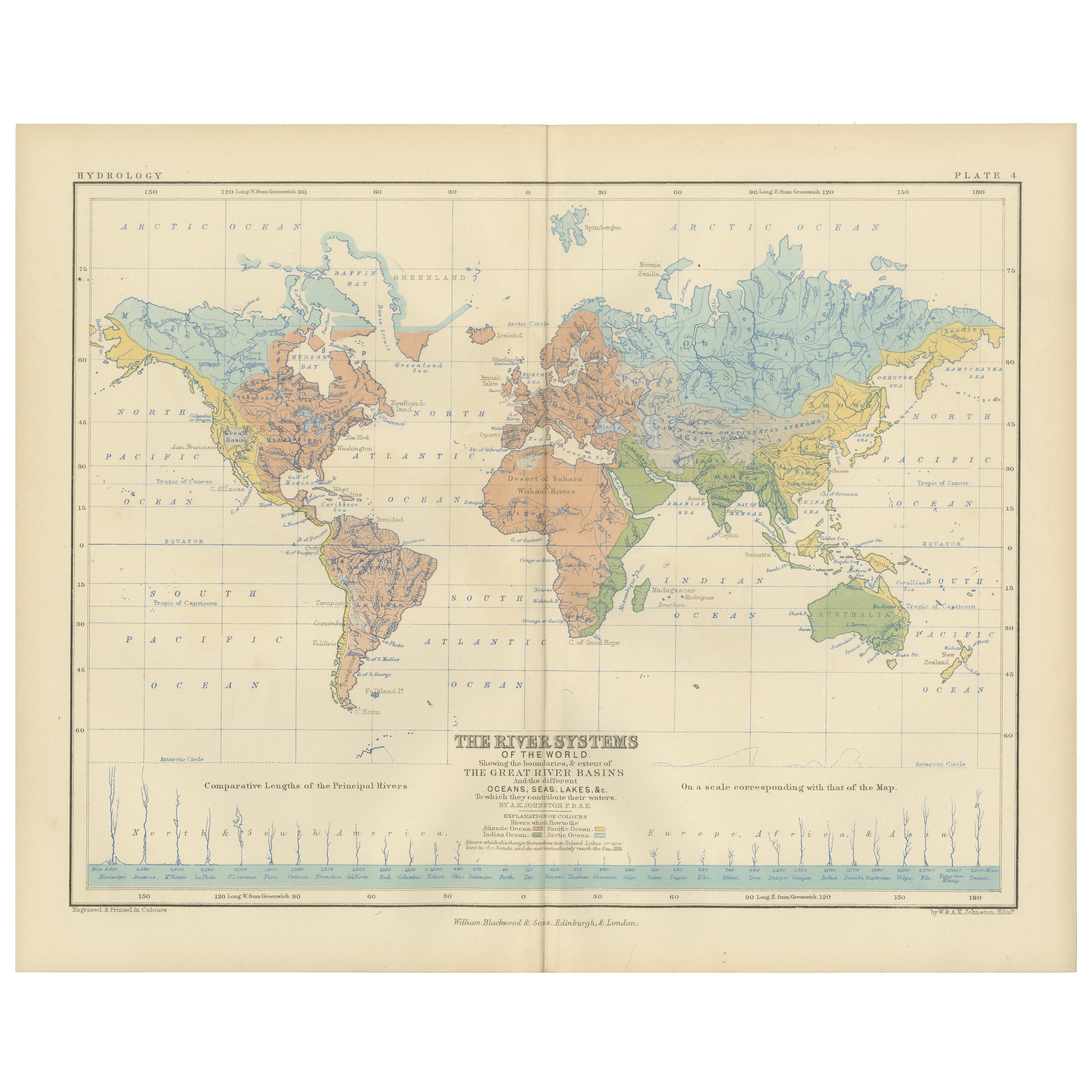
Ver todoRiver Systems Map of the World by A.K. Johnston – Educational Print 1852
River Systems Map of the World by A.K. Johnston – Educational Print 1852
This striking 1852 map titled "The River Systems of the World" was created by the noted Scottish geographer ...
Categoría
Antiguo, Mediados del siglo XIX, Escocés, Impresiones
Materiales
Papel

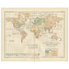
Mapa antiguo de las religiones del mundo por Johnston '1854
Mapa antiguo titulado "Cuadro moral y estadístico de la distribución geográfica del hombre según las creencias religiosas". Raro mapa temático de gran tamaño sobre la distribución de...
Categoría
Antiguo, Mediados del siglo XIX, Mapas
Materiales
Papel

780 € Precio de venta
Descuento del 35 %
Religious Belief Map by A.K. Johnston – Moral and Statistical Chart 1852
Religious Belief Map by A.K. Johnston – Moral and Statistical Chart 1852
This antique chart titled "Moral & Statistical Chart Showing the Distribution of Man According to Prevailing...
Categoría
Antiguo, Mediados del siglo XIX, Escocés, Impresiones
Materiales
Papel
Mapa antiguo del mundo con la distribución de plantas y minerales, 1872
Mapa antiguo titulado 'El mundo de Johnson mostrando la distribución de los árboles forestales característicos (..)'. Mapamundi original que muestra la distribución de plantas y mine...
Categoría
Antiguo, Fines del siglo XIX, Mapas
Materiales
Papel

160 € Precio de venta
Descuento del 20 %
Mapa antiguo que muestra la división y distribución de los mamíferos por Johnston '1850
Mapa antiguo titulado "División geográfica y distribución de los mamíferos de los órdenes rodentia y ruminantia en el globo". Mapa original antiguo que muestra la división geográfica...
Categoría
Antiguo, Mediados del siglo XIX, Mapas
Materiales
Papel

160 € Precio de venta
Descuento del 20 %
Mapa antiguo que muestra la distribución de las plantas por Johnston '1850
Mapa antiguo titulado "Plantas geográficas que sirven de alimento al hombre". Mapa antiguo original que muestra la distribución de las plantas. Este mapa procede de "El Atlas Físico ...
Categoría
Antiguo, Mediados del siglo XIX, Mapas
Materiales
Papel
160 € Precio de venta
Descuento del 20 %
También te puede gustar
Mapa Antiguo Original del Mundo por Dower, circa 1835
Bonito mapa del Mundo
Dibujado y grabado por J.Dower
Publicado por Orr & Smith. C.1835
Sin enmarcar.
Envío gratuito
Categoría
Antiguo, Década de 1830, Inglés, Mapas
Materiales
Papel

1864 Planisferio ilustrado original - Mapamundi - Geografía
Sumérgete en el viaje épico del pasado con el Planisferio Histórico Ilustrado de 1864 de Charpentier! 🗺️ Este tesoro cartográfico te transporta a través de los entresijos de la hist...
Categoría
Década de 1860, Impresiones y múltiplos
Materiales
Lino, Litografía, Papel

Mapa antiguo del Imperio Británico - Mapa antiguo de Karl Spruner - 1760 ca.
Por Karl Spruner von Merz
Antiguo mapa del Imperio Británico es una obra de arte realizada hacia 1760 por Karl Spruner.
Grabado original coloreado a mano.
Buen estado, salvo por el amarilleamiento del papel...
Categoría
Década de 1760, Moderno, Impresiones figurativas
Materiales
Grabado químico

Mapa del Mundo - Grabado original - 1820
Mapa del Mundo es un Grabado Original realizado por un artista desconocido del siglo XIX en 1820.
Muy buen estado en dos hojas de papel blanco unidas por el centro.
El mapa es un a...
Categoría
Década de 1820, Moderno, Impresiones figurativas
Materiales
Grabado químico

Antiguo mapa original del mundo de Thomas Clerk, 1817
Gran mapa de los hemisferios oriental y occidental
En 2 hojas
Grabado en cobre
Dibujado y grabado por Thomas Clerk, Edimburgo.
Publicado por Mackenzie And Dent, 1817
S...
Categoría
Antiguo, Década de 1810, Inglés, Mapas
Materiales
Papel

Mapa Antiguo Original del Hemisferio Oriental por Dower, hacia 1835
Bonito mapa del hemisferio oriental
Dibujado y grabado por J.Dower
Publicado por Orr & Smith. C.1835
Sin enmarcar.
Envío gratuito
Categoría
Antiguo, Década de 1830, Inglés, Mapas
Materiales
Papel
