Artículos similares a Geological Map of the British Isles by A.K. Johnston – Highlands & Valleys 1852


¿Quieres más imágenes o vídeos?
Solicita imágenes o vídeos adicionales al vendedor
1 de 10
Geological Map of the British Isles by A.K. Johnston – Highlands & Valleys 1852
260 €por artículo|IVA incluido
Cantidad
Envío
Recuperando presupuesto…La promesa de 1stDibs
Garantía de autenticidad,
Garantía de devolución de dinero,
Cancelación dentro de las 24 horas
Acerca del artículo
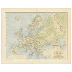
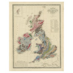
Geological Map of the British Isles by A.K. Johnston – Highlands & Valleys 1852
This antique topographic map titled "The Mountains, Table Lands, Plains & Valleys of the British Isles" was created by Alexander Keith Johnston and published in 1852 by William Blackwood & Sons in Edinburgh and London. It forms Plate 10 in Johnston’s landmark *Physical Atlas of Natural Phenomena*, one of the most influential works of thematic cartography of the 19th century.
The map offers a clear and scientific representation of the physical geography of Great Britain and Ireland, highlighting major mountain ranges, highlands, plains, river valleys, and tablelands using fine engraved detail and hand-applied color washes. Rather than depicting political boundaries, this plate focuses entirely on natural landforms and their elevations, providing insight into the geological character of the region.
Key physical features include the Highlands and Grampians of Scotland, the Pennines in northern England, the Cambrian Mountains of Wales, and the Cumbrian Fells. Ireland is shown with its central lowlands ringed by uplands, and an inset in the upper right corner details the Shetland Islands. Rivers such as the Thames, Shannon, Severn, and Clyde are precisely mapped, and lowland basins like those surrounding the Wash and the Fens are delicately shaded in green.
This map reflects the mid-19th century shift from political and colonial maps to scientific and thematic cartography. Alexander Keith Johnston (1804–1871), Geographer in Ordinary to Queen Victoria in Scotland, was one of the leading cartographic figures of his time. His *Physical Atlas* was the first to systematically visualize natural phenomena on a global scale through beautifully engraved and colored maps. This map is part of that series and stands as a testament to the combination of precision, clarity, and aesthetic quality in Victorian scientific publishing.
Highly collectible and still relevant today, this plate is perfect for historians, educators, or anyone with an interest in British natural history and geography.
Condition and framing tips:
Very good antique condition with minor age toning and a clean printed surface. Original centerfold as issued.
Ideal for framing in walnut, oak, or black wood with a warm ivory or cool grey mat to complement the greens and earth tones. A beautiful addition to a study, library, or historically inspired interior.
- Dimensiones:Altura: 34,5 cm (13,59 in)Anchura: 27,4 cm (10,79 in)Profundidad: 0,2 mm (0,01 in)
- Materiales y técnicas:
- Lugar de origen:
- Época:
- Fecha de fabricación:1852
- Estado:Very good condition. Light overall toning near the margins. The paper remains strong and well-preserved. Folding line as issued.
- Ubicación del vendedor:Langweer, NL
- Número de referencia:Vendedor: BG-13207-101stDibs: LU3054345388152
Sobre el vendedor
5,0
Vendedor reconocido
Estos prestigiosos vendedores son líderes del sector y representan el escalón más alto en cuanto a calidad y diseño de artículos.
Vendedor Platino
Vendedores premium con una calificación de +4,7 y tiempos de respuesta de 24 horas
Establecido en 2009
Vendedor de 1stDibs desde 2017
2502 ventas en 1stDibs
Tiempo de respuesta usual: <1 hora
- EnvíoRecuperando presupuesto…Envío desde: Langweer, Países Bajos
- Política de devolución
Partes de esta página se han traducido automáticamente. 1stDibs no puede garantizar la exactitud de las traducciones. El inglés es el idioma predeterminado de este sitio web.
Garantía de autenticidad
En el improbable caso de que haya algún problema con la autenticidad de un artículo, ponte en contacto con nosotros en un plazo de 1 año para recibir un reembolso total. DetallesGarantía de devolución de dinero
Si tu artículo no es como se describe, sufre daños durante el transporte o no llega, ponte en contacto con nosotros en un plazo de 7 días para recibir un reembolso total. DetallesCancelación dentro de las 24 horas
Tienes un período de gracia de 24 horas para reconsiderar tu compra, sin preguntas.Vendedores profesionales aprobados
Nuestros vendedores de primera clase deben cumplir estrictos estándares de servicio para mantener la integridad de nuestros anuncios.Garantía de igualación de precios
Si encuentras que un vendedor publicó el mismo artículo por un precio menor en otro lado, igualaremos ese precio.Entrega global de confianza
Nuestra red de transporte de primera ofrece opciones de envío especializado en todo el mundo, que incluye envío personalizado.Más de este vendedor
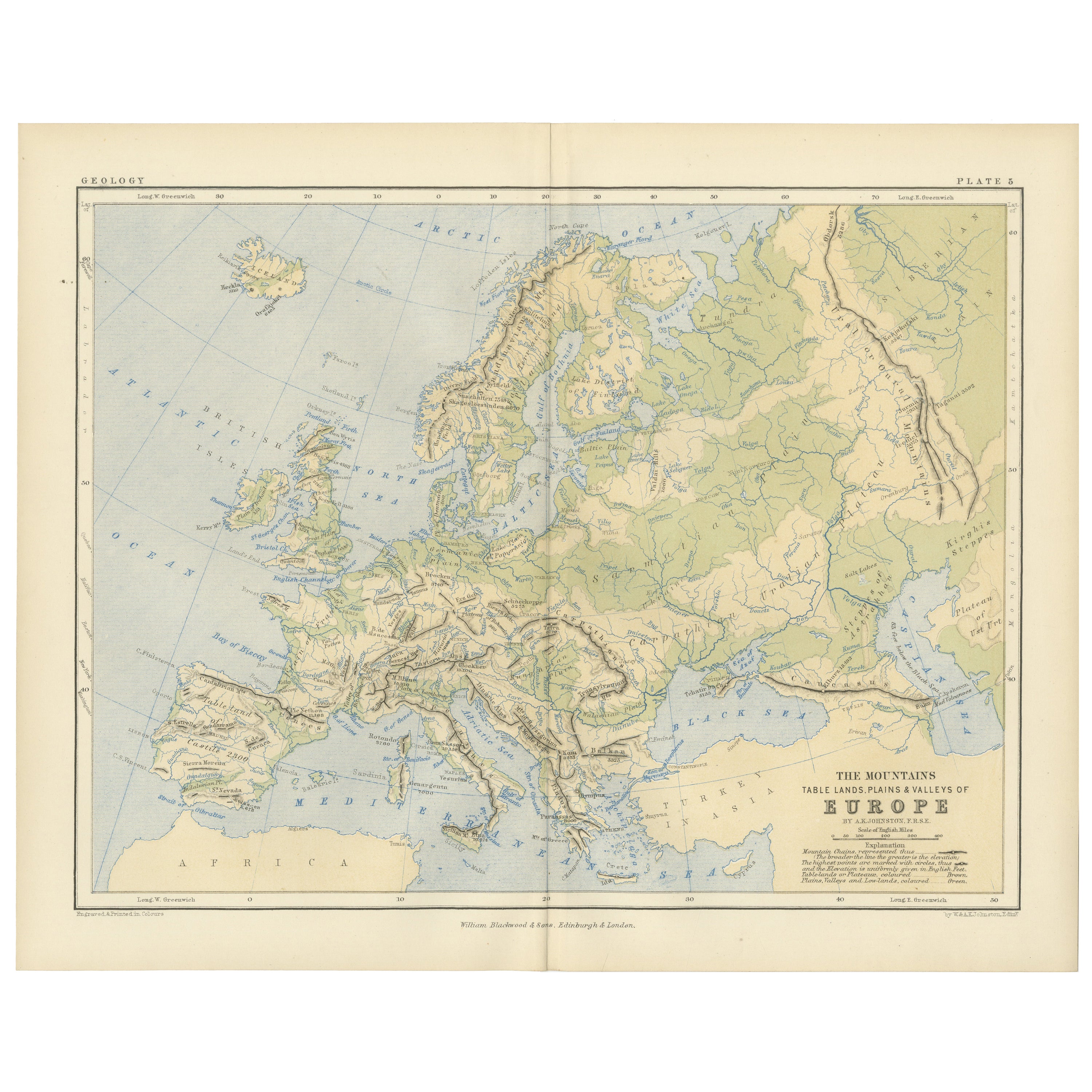
Ver todoGeological Map of Europe by A.K. Johnston – Mountains and Valleys 1852
Geological Map of Europe by A.K. Johnston – Mountains and Valleys 1852
This elegant 1852 map titled "The Mountains, Table Lands, Plains & Valleys of Europe" was designed by the accl...
Categoría
Antiguo, Mediados del siglo XIX, Escocés, Impresiones
Materiales
Papel
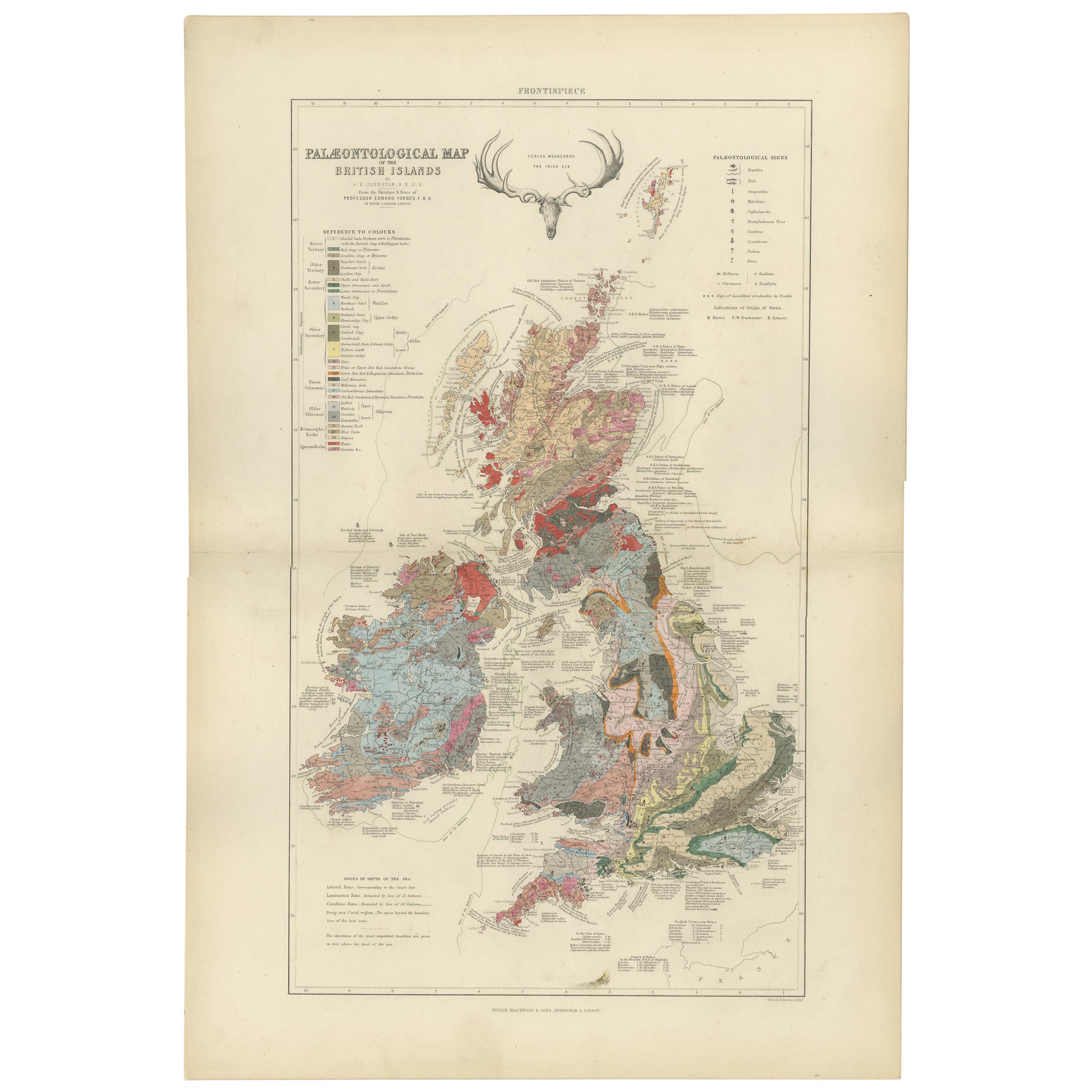
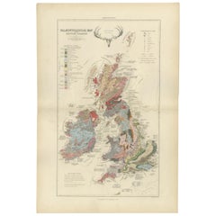
Mapa Antiguo de la Paleontología de las Islas Británicas por Johnston '1850
Mapa antiguo titulado "Mapa paleontológico de las Islas Británicas". Mapa antiguo original que muestra la paleontología de las Islas Británicas. Este mapa procede de "El Atlas Físico...
Categoría
Antiguo, Mediados del siglo XIX, Mapas
Materiales
Papel
360 € Precio de venta
Descuento del 20 %
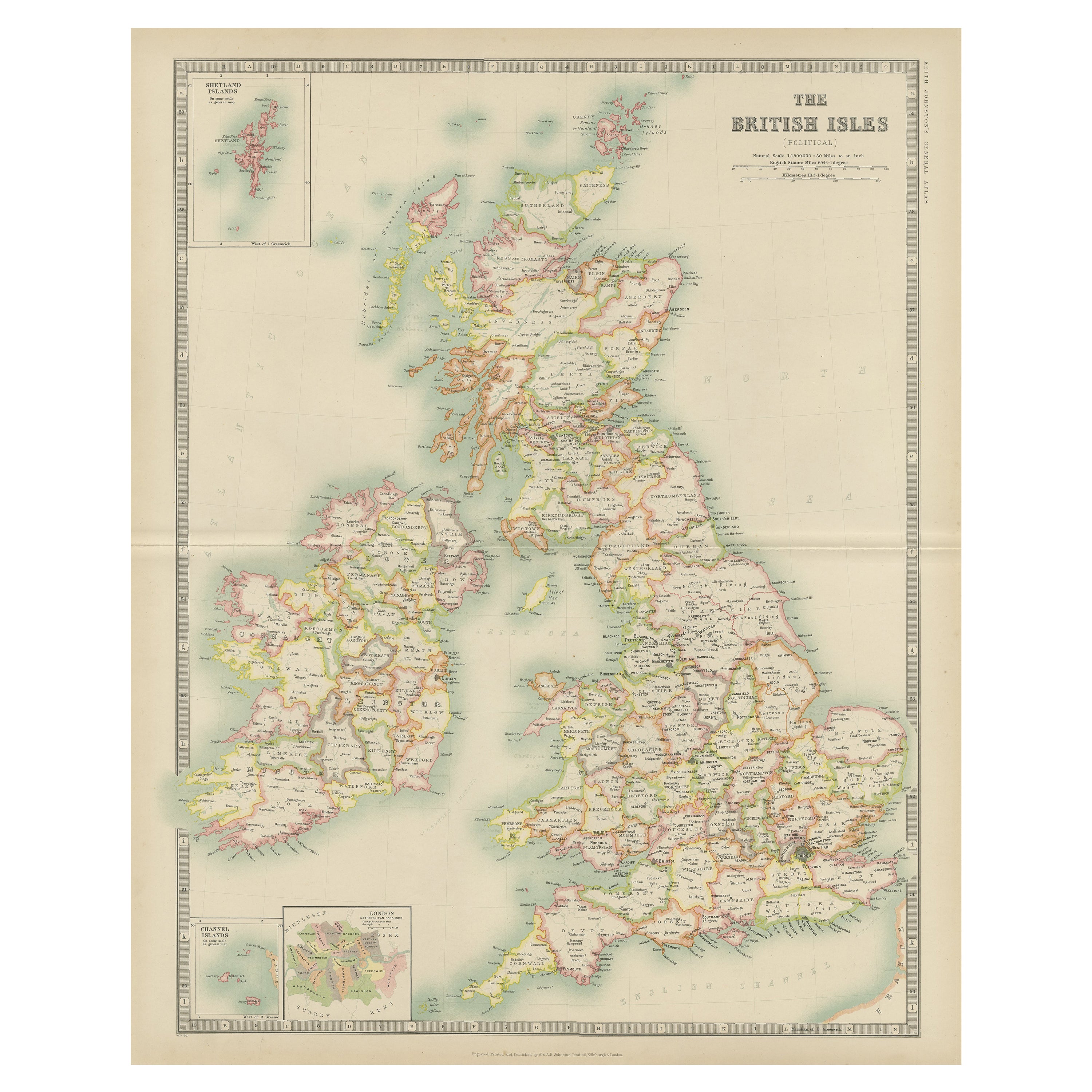
Mapa antiguo de las Islas Británicas por Johnston '1909
Mapa antiguo titulado "Las Islas Británicas". Mapa antiguo original de las Islas Británicas. Con mapas insertados de las islas Shetland, las islas Chanel y Londres. Este mapa procede...
Categoría
principios del siglo XX, Mapas
Materiales
Papel
200 € Precio de venta
Descuento del 20 %
Bajo la superficie: El Mapa Geológico de las Islas Británicas de 1844 de James Wyld
Este magnífico mapa geológico original del Reino Unido de Gran Bretaña e Irlanda, realizado por James Wyld en 1844, es un extraordinario artefacto victoriano.
Descripción:
Explora...
Categoría
Antiguo, Década de 1840, Mapas
Materiales
Papel
720 € Precio de venta
Descuento del 20 %
Mapa antiguo de las Islas Británicas por Balbi '1847
Mapa antiguo titulado "Iles Britanniques". Mapa antiguo original de las Islas Británicas. Este mapa procede del "Abrégé de Géographie (..)" de Adrien Balbi. Publicado en 1847.
Categoría
Antiguo, Mediados del siglo XIX, Mapas
Materiales
Papel

120 € Precio de venta
Descuento del 20 %
Mapa antiguo de Inglaterra y Gales "Norte" por A.K. Johnston, 1865
Mapa antiguo titulado "Inglaterra y Gales (Hoja Norte)". Este mapa procede del "Atlas Real de Geografía Moderna" de Alexander Keith Johnston. Publicado por William Blackwood and Sons...
Categoría
Antiguo, Mediados del siglo XIX, Mapas
Materiales
Papel

220 € Precio de venta
Descuento del 20 %
También te puede gustar
Mapa original antiguo de Escocia por Dower, hacia 1835
Bonito mapa de Escocia
Dibujado y grabado por J.Dower
Publicado por Orr & Smith. C.1835
Sin enmarcar.
Envío gratuito
Categoría
Antiguo, Década de 1830, Inglés, Mapas
Materiales
Papel

Inglaterra y Gales, Parte Norte. Atlas del Siglo mapa antiguo de época
El Atlas del Siglo. Inglaterra y Gales, Parte Norte".
Mapa antiguo original, 1903.
Pliegue central como se emitió. Nombre y número del mapa impresos en las esquinas del reverso.
Ho...
Categoría
principios del siglo XX, Victoriano, Más impresiones
Materiales
Litografía

Gran Mapa Vintage Original del Reino Unido, circa 1920
Gran mapa del Reino Unido
Sin enmarcar
Color original
Por John Bartholomew y Co. Instituto Geográfico de Edimburgo
Publicado, hacia 1920
Envío gratuito.
Categoría
Vintage, Década de 1920, Británico, Mapas
Materiales
Papel

Inglaterra, Escocia e Irlanda: Un mapa de Gran Bretaña coloreado a mano por Tirion
Por Isaak Tirion
Se trata de un mapa de Gran Bretaña coloreado a mano en cobre a doble página, titulado "Nieuwe Kaart van de Eilanden van Groot Brittannien Behelzende de Koningryken Engeland, Schotla...
Categoría
Antiguo, mediados del siglo XVIII, Holandés, Mapas
Materiales
Papel

Antiguo mapa horizontal de Inglaterra
Por Tasso
ST/520 - Antiguo y raro mapa italiano de Inglaterra, fechado en 1826-1827 - por Girolamo Tasso, editor en Venise, para el atlas de M.r Le-Sage.
Categoría
Antiguo, principios del siglo XIX, Italiano, Otro, Impresiones
Materiales
Papel

Inglaterra y las Islas Británicas: Un gran mapa coloreado a mano del siglo XVII por de Wit
Por Frederick de Wit
Se trata de un gran mapa coloreado a mano del siglo XVII de Inglaterra y las Islas Británicas, obra de Frederick de Wit, titulado "Accuratissima Angliæ Regni et Walliæ Principatus", ...
Categoría
finales del siglo XVII, Otro estilo de arte, Impresiones de paisajes
Materiales
Grabado
