Artículos similares a 1896 "Territory of Arizona" Map, Published by the General Land Office

¿Quieres más imágenes o vídeos?
Solicita imágenes o vídeos adicionales al vendedor
1 de 9
1896 "Territory of Arizona" Map, Published by the General Land Office
2387,94 €
Envío
Recuperando presupuesto…La promesa de 1stDibs
Garantía de autenticidad,
Garantía de devolución de dinero,
Cancelación dentro de las 24 horas
Acerca del artículo
Presented is an attractive "Territory of Arizona” map, from the “Report of the Governor of Arizona to the Secretary of the Interior." First published in 1894, this 1896 edition was revised and reconstructed by R. H. Morton and published by the General Land Office, based on “official Records of the General Land Office and other sources under the supervision of Harry King, C.E.” The report gave extensive detail regarding the territory’s population, including Native Americans of Arizona, the agriculture, mining, taxation, banks, transportation, immigration and tourism, as well as the current challenges to the territory’s development. This beautifully colored and highly detailed map was bound in the back of the 142 page Report. The map was lettered by M. Hendges and R.M. Towson.
The map is outlined by county in pink and detailed in black, with town names, roads, wagon roads, railroads, and mountains labeled. Intricate brown hachured mountain areas and the blue waterways combine to provide great visual impact. The map shows the extent of nine Indian reservations, outlined in green, and at least four military reservations, including Fort Apache, colored in solid red. The Grand Canyon is also shown and labeled as a Forest Reserve in pale pink. Any private land claims, confirmed and unconfirmed, are outlined in red, while townships not yet subdivided are identified with a circled cross.
Arizona, formerly part of the Territory of New Mexico, was organized as a separate territory on February 24, 1863. The United States acquired the region under the terms of the 1848 Treaty of Guadalupe Hidalgo and the 1853 Gadsden Purchase.
In the 1870s and 1880s, particularly after the arrival of the railroad in 1880, the population of the Arizona Territory expanded rapidly. With many Native American tribes relocated to reservations, white settlers drawn by the rich agricultural and mineral resources arrived in the region. Gold was discovered in 1863 near the first capital, Prescott. The 1877 discoveries of silver at Tombstone, near Tucson, and copper at Bisbee, also brought many settlers hoping to strike it rich. Many Mormon settlers moved south from Utah and Mexicans emigrated north. The flow of European emigrants also increased markedly thanks to the railroad. By the beginning of the 20th century, the population of the Arizona Territory exceeded 100,000. As the population grew, there was increasing sentiment for statehood, which was finally granted in 1912.
CONDITION:
Very good condition. Lithographed folding map, printed with original color. Map paper is lightly toned, color is strong and attractive. Fold lines, as issued. The map was removed from the original "Report of the Governor of Arizona to the Secretary of the Interior" booklet. Original booklet included. The booklet has red paper covers,142 pages with text and tables describing the territory including immigration, taxation, mining, banks, railroads, and much more. The booklet binding is tight and paper is clean, but the red paper covers have wear and lifting at the spine and a small chip at the right edge on the front cover.
Accompanied by our company's letter of authenticity.
- Dimensiones:Altura: 73,03 cm (28,75 in)Anchura: 63,5 cm (25 in)Profundidad: 2,54 cm (1 in)
- Materiales y técnicas:
- Época:
- Fecha de fabricación:1896
- Estado:Adiciones o alteraciones hechas al original: Framed according to archival standards by Artem Art Services in Colorado Springs, CO. Desgaste acorde con la edad y el uso.
- Ubicación del vendedor:Colorado Springs, CO
- Número de referencia:Vendedor: M3921stDibs: LU909745349572
Sobre el vendedor
4,9
Vendedor Platino
Vendedores premium con una calificación de +4,7 y tiempos de respuesta de 24 horas
Establecido en 2010
Vendedor de 1stDibs desde 2011
461 ventas en 1stDibs
- EnvíoRecuperando presupuesto…Envío desde: Colorado Springs, CO
- Política de devolución
Partes de esta página se han traducido automáticamente. 1stDibs no puede garantizar la exactitud de las traducciones. El inglés es el idioma predeterminado de este sitio web.
Garantía de autenticidad
En el improbable caso de que haya algún problema con la autenticidad de un artículo, ponte en contacto con nosotros en un plazo de 1 año para recibir un reembolso total. DetallesGarantía de devolución de dinero
Si tu artículo no es como se describe, sufre daños durante el transporte o no llega, ponte en contacto con nosotros en un plazo de 7 días para recibir un reembolso total. DetallesCancelación dentro de las 24 horas
Tienes un período de gracia de 24 horas para reconsiderar tu compra, sin preguntas.Vendedores profesionales aprobados
Nuestros vendedores de primera clase deben cumplir estrictos estándares de servicio para mantener la integridad de nuestros anuncios.Garantía de igualación de precios
Si encuentras que un vendedor publicó el mismo artículo por un precio menor en otro lado, igualaremos ese precio.Entrega global de confianza
Nuestra red de transporte de primera ofrece opciones de envío especializado en todo el mundo, que incluye envío personalizado.Más de este vendedor
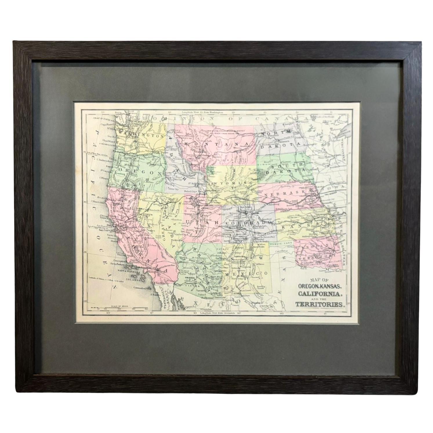
Ver todo1890 "Mapa de Oregón, Kansas, California y los Territorios" por S. A. Mitchell
Por Samuel Augustus Mitchell 1
Se presenta un mapa de 1890 "Mapa de Oregón, Kansas, California y los Territorios" de S. A. Mitchell Jr. El mapa se publicó en el atlas "Nueva Geografía Intermedia de Mitchell", edit...
Categoría
Antiguo, Década de 1890, Estadounidense, Victoriano, Mapas
Materiales
Papel

Mapa de 1840 de la ciudad de Washington Publicado por William M. Morrison
Este mapa, impreso en 1840, es una representación detallada de Washington D.C. a mediados del siglo XIX. El mapa muestra números de manzana, distritos y edificios gubernamentales, as...
Categoría
Antiguo, Década de 1840, Estadounidense, Federal, Mapas
Materiales
Papel

Mapa mural de 1842 de los Estados Unidos por J. H. Young, publicado por S. A. Mitchell
Se presenta un "Mapa de Estados Unidos" colgado de 1842, grabado por J. H. Young y publicado por Samuel Augustus Mitchell, Filadelfia. Éste es un bello ejemplar de la rara edición de...
Categoría
Antiguo, Década de 1840, Estadounidense, Mapas
Materiales
Papel

"Taylor y sus generales", primera edición, publicada por E. H. Butler & Co., 1847.
Taylor y sus generales. Nueva York: E.H. Butler & Co., 1847. Primera edición. Encuadernado en cuarto de cuero y sobrecubiertas de papel de mármol. En estuche personalizado.
Se prese...
Categoría
Antiguo, Década de 1840, Estadounidense, Libros
Materiales
Papel

1859 "Mapa de los Estados Unidos de América..." por J.H. Colton
Por J.H. Colton
Se presenta un "Mapa de los Estados Unidos de América, las Provincias Británicas, México, las Indias Occidentales y América Central con parte de Nueva Granada y Venezuela" de 1859, p...
Categoría
Antiguo, Década de 1850, Estadounidense, Mapas
Materiales
Papel

1847 Mapa ornamental de Estados Unidos y México por H. Phelps
Se ofrece un mapa ornamental original de 1847 de los EE.UU. titulado "Mapa Ornamental de los Estados Unidos y México" por Humphrey Phelps. El mapa fue emitido como un acto del Congre...
Categoría
Antiguo, Década de 1840, Estadounidense, Mapas
Materiales
Papel

También te puede gustar
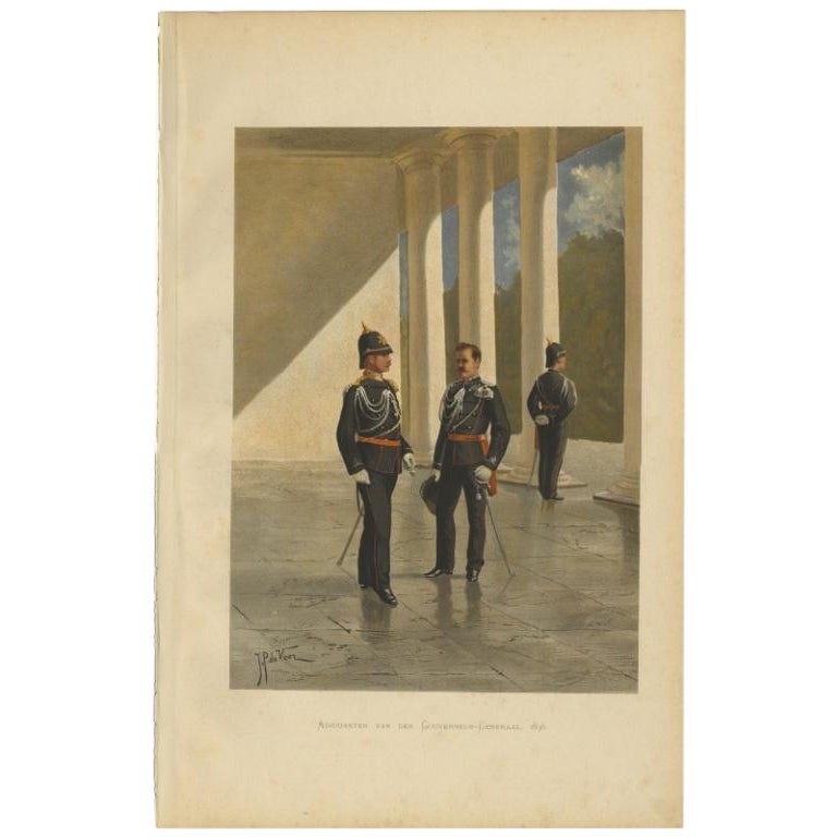
Ayudantes del Gobernador General de las Indias Orientales Neerlandesas "1896", 1900
Grabado antiguo, titulado: 'Adjudanten van den Gouveneur-Generaal 1896'. - Esta lámina muestra a los ayudantes del Gobernador General de las Indias Orientales Neerlandesas en 1896.
...
Categoría
siglo XX, Impresiones
Materiales
Papel

100 € Precio de venta
Descuento del 20 %
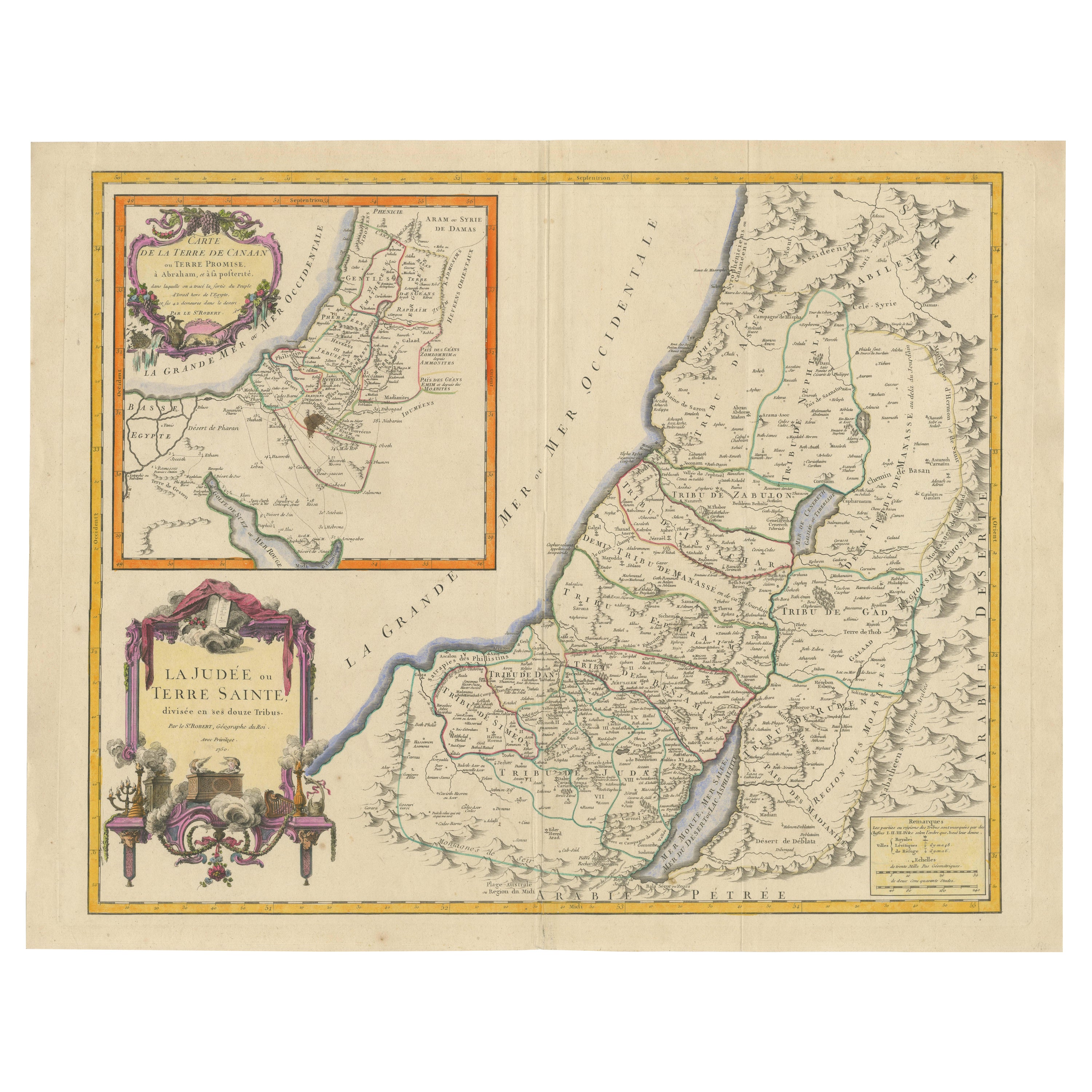
Mapa de Tierra Santa de 1750: La Tierra de Canaán y las Doce Tribus
Carta de la Tierra de Canaán o Tierra Prometida
Cartógrafo: Le St. Robert
Fecha de publicación: 1750
Este exquisito mapa del siglo XVIII, "Carte de la Terre de Canaan ou Terre Promi...
Categoría
Antiguo, Década de 1750, Mapas
Materiales
Papel

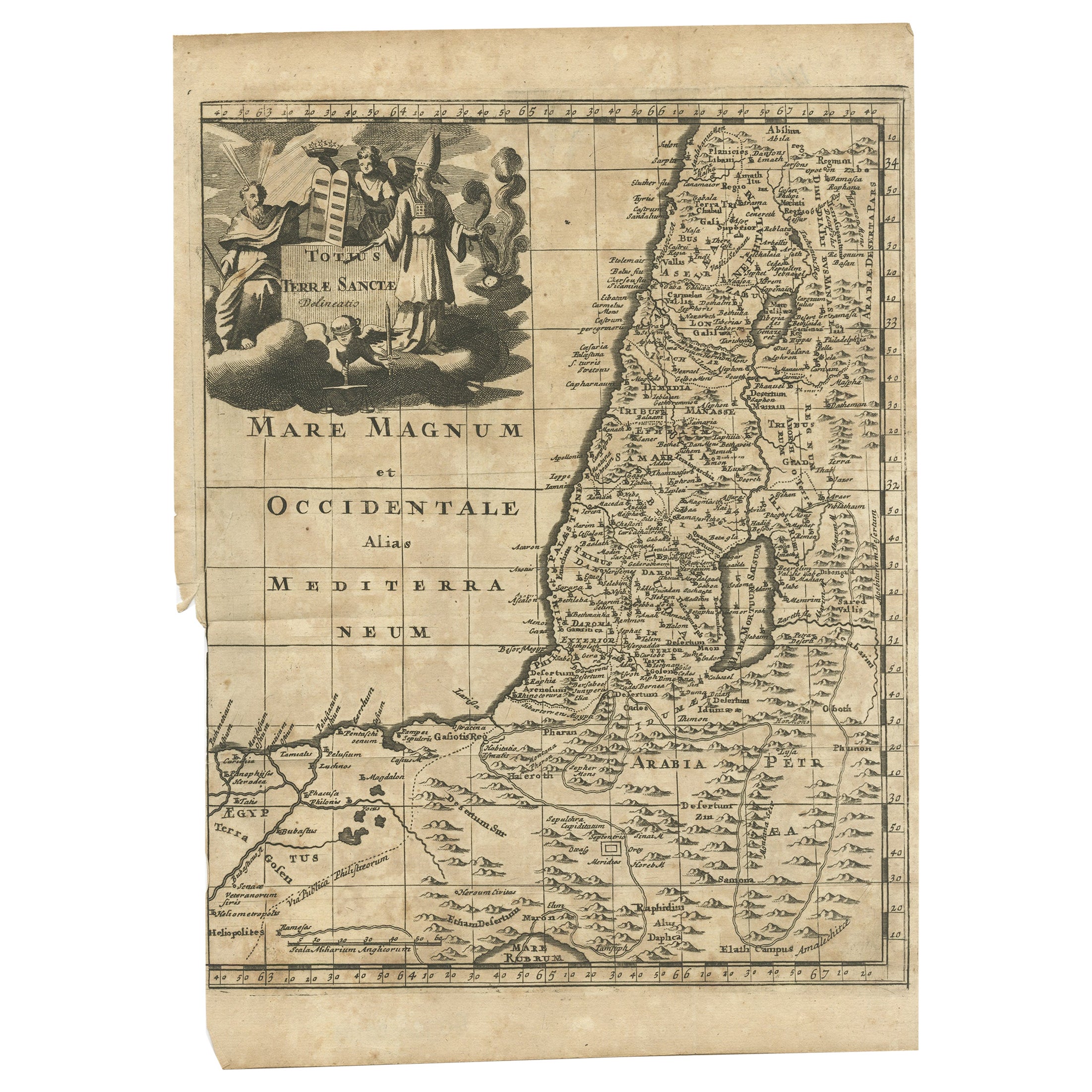
Mapa antiguo de Tierra Santa por Schut, 1710
Mapa antiguo de Tierra Santa titulado 'Het Beloofde Landt Canaan'. Mapa muy detallado y decorativo de Tierra Santa adornado con veleros y rosa de los vientos. Texto en neerlandés en ...
Categoría
Antiguo, siglo XVIII, Mapas
Materiales
Papel

336 € Precio de venta
Descuento del 20 %
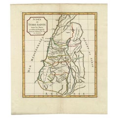
Mapa antiguo de Tierra Santa por Delamarche, 1806
Por Charles Francois Delamarche
Mapa antiguo titulado "Judee ou Terre Sainte sous les Turcs". Este mapa muestra la Tierra Santa bajo los turcos. Por Robert de Vaugondy, revisado y publicado por Delamarche. Fuente d...
Categoría
Antiguo, siglo XIX, Mapas
Materiales
Papel
Mapa antiguo de Tierra Santa por Keur, 1748
Mapa antiguo de Tierra Santa titulado "De Gelegentheyd van t'Paradys ende t'Landt Canaan, Mitsgaders d'eerst bewoonde Landen der Patriarchen". Incluye cinco viñetas decorativas, como...
Categoría
Antiguo, siglo XVIII, Mapas
Materiales
Papel

278 € Precio de venta
Descuento del 20 %
Mapa antiguo de Tierra Santa por Danckerts, c.1710
Mapa antiguo titulado "Afbeeldinge van de Veertich-Iaarige Reyse der Kinderen Israëls uyt Egypten door de Roode Zee en de Woestyne tot in 't Beloofde Landt Canaan". Mapa de Tierra Sa...
Categoría
Antiguo, siglo XVIII, Mapas
Materiales
Papel

285 € Precio de venta
Descuento del 20 %