Artículos similares a Map of Ariège France with Foix and Pyrenees Landscape by Vuillemin, 19th c


¿Quieres más imágenes o vídeos?
Solicita imágenes o vídeos adicionales al vendedor
1 de 11
Map of Ariège France with Foix and Pyrenees Landscape by Vuillemin, 19th c
120 €IVA incluido
Acerca del artículo
Map of Ariège France with Foix and Pyrenees Landscape by Vuillemin, 19th c
Description:
This beautifully detailed 19th-century map of the Ariège department in southwestern France was drawn by the French cartographer Alexandre Vuillemin and published by Migeon in Paris as part of the illustrated Nouvel Atlas Illustré. Rich in visual and historical content, the map offers a fascinating portrait of this mountainous border region adjacent to Spain and Andorra.
The map shows the full expanse of Ariège with clear labeling of towns, rivers, roads, and departmental borders, the latter highlighted in hand-applied yellow watercolor. The department is nestled against the Pyrenees mountain range, with Foix, Saint-Girons, and Pamiers as its major towns. The topographical relief hints at the region's rugged alpine character.
To the lower left is a picturesque vignette of Foix, the departmental capital, with its famous medieval castle perched dramatically on a rocky hill above the town. On the lower right is a view of the southern borderlands facing the Spanish frontier. At the upper right appears a portrait of General Bertrand Clausel, a native of Ariège who served in the Napoleonic Wars and later became governor of Algeria. Beneath him is the coat of arms of the department, with its vertical stripes and laurel branch motif.
Ariège is known for its striking mountain scenery, medieval fortresses, Cathar heritage, and natural thermal springs. Although not widely recognized as a major wine-producing area, it does have a tradition of small-scale viticulture, especially in the foothills, with rustic wines from local grapes. The area is more renowned for sheep cheese (such as tomme and Bethmale), honey, and mountain herbal products. Today, it is popular among hikers, cyclists, and nature lovers for its unspoiled valleys and ancient hilltop villages.
Alexandre Vuillemin was a leading 19th-century French cartographer noted for integrating history, culture, and art into his maps. His works were both educational and decorative, making them highly collectible. The publisher, Migeon, specialized in atlases that appealed to a broad public through refined design and engraving quality.
Condition summary:
Very good condition with light age toning and a few minor foxing marks in the margins. Engraved lines are sharp, and the hand coloring is clean and well preserved.
Framing tips:
This map would look excellent in a walnut or natural wood frame to complement its rustic and mountainous theme. A soft cream or ivory mat will enhance the engraved detail and yellow border. Museum glass is recommended for optimal preservation.
- Dimensiones:Altura: 26,1 cm (10,28 in)Anchura: 32,5 cm (12,8 in)Profundidad: 0,2 mm (0,01 in)
- Materiales y técnicas:Papel,Grabado
- Lugar de origen:
- Época:
- Fecha de fabricación:circa 1850
- Estado:Very good condition with light age toning and a few minor foxing marks in the margins. Engraved lines are sharp, and the hand coloring is clean and well preserved.
- Ubicación del vendedor:Langweer, NL
- Número de referencia:Vendedor: BG-13331-81stDibs: LU3054345359562
Sobre el vendedor
5,0
Vendedor reconocido
Estos prestigiosos vendedores son líderes del sector y representan el escalón más alto en cuanto a calidad y diseño de artículos.
Vendedor Platino
Vendedores premium con una calificación de +4,7 y tiempos de respuesta de 24 horas
Establecido en 2009
Vendedor de 1stDibs desde 2017
2567 ventas en 1stDibs
Tiempo de respuesta usual: <1 hora
- EnvíoRecuperando presupuesto…Envío desde: Langweer, Países Bajos
- Política de devolución
Partes de esta página se han traducido automáticamente. 1stDibs no puede garantizar la exactitud de las traducciones. El inglés es el idioma predeterminado de este sitio web.
Garantía de autenticidad
En el improbable caso de que haya algún problema con la autenticidad de un artículo, ponte en contacto con nosotros en un plazo de 1 año para recibir un reembolso total. DetallesGarantía de devolución de dinero
Si tu artículo no es como se describe, sufre daños durante el transporte o no llega, ponte en contacto con nosotros en un plazo de 7 días para recibir un reembolso total. DetallesCancelación dentro de las 24 horas
Tienes un período de gracia de 24 horas para reconsiderar tu compra, sin preguntas.Vendedores profesionales aprobados
Nuestros vendedores de primera clase deben cumplir estrictos estándares de servicio para mantener la integridad de nuestros anuncios.Garantía de igualación de precios
Si encuentras que un vendedor publicó el mismo artículo por un precio menor en otro lado, igualaremos ese precio.Entrega global de confianza
Nuestra red de transporte de primera ofrece opciones de envío especializado en todo el mundo, que incluye envío personalizado.Más de este vendedor
Ver todoMap of Ardèche France with Annonay and Vineyards by Vuillemin, 19th c
Map of Ardèche France with Annonay and Vineyards by Vuillemin, 19th c
This beautifully engraved 19th-century map of Ardèche, a department in southeastern France, comes from Alexandr...
Categoría
Antiguo, Mediados del siglo XIX, Francés, Mapas
Materiales
Papel

Map of Côtes-du-Nord France with Saint-Brieuc and Brittany Coastline, c.1850
Map of Côtes-du-Nord France with Saint-Brieuc and Brittany Coastline, 19th c
Description:
This elegant 19th-century map of Côtes-du-Nord, the historic name for what is now known as ...
Categoría
Antiguo, Mediados del siglo XIX, Francés, Mapas
Materiales
Papel

Map of Allier France with Saint-Pourçain Wine Region by Vuillemin, 19th c
Map of Allier France with Saint-Pourçain Wine Region by Vuillemin, 19th c
This decorative 19th-century map of Allier, a central department of France, comes from the celebrated Nouve...
Categoría
Antiguo, Mediados del siglo XIX, Francés, Mapas
Materiales
Papel

Map of Aude France with Carcassonne and Languedoc Vineyards, 19th Century
Map of Aude France with Carcassonne and Languedoc Vineyards, 19th Century
Description:
This elegant 19th-century map of Aude, a department in southern France along the Mediterranean...
Categoría
Antiguo, Mediados del siglo XIX, Francés, Mapas
Materiales
Papel

Map of Aisne France with Soissons and Champagne Vineyards by Vuillemin, 19th c
Map of Aisne France with Soissons and Champagne Vineyards by Vuillemin, 19th c
Description:
This richly detailed 19th-century engraved and hand-colored map of the department of Aisn...
Categoría
Antiguo, Mediados del siglo XIX, Francés, Mapas
Materiales
Papel

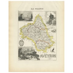
Map of Aveyron France with Rodez, Millau and Wine Routes, 19th Century
Map of Aveyron France with Rodez, Millau and Wine Routes, 19th Century
Description:
This detailed and decorative 19th-century map of Aveyron, a department in southern France, was dr...
Categoría
Antiguo, Mediados del siglo XIX, Francés, Mapas
Materiales
Papel
También te puede gustar
Lozere, Francia. Mapa antiguo de un departamento francés, 1856
Por Victor Levasseur
Dept. de La Lozere", grabado en acero con contorno original coloreado a mano, 1856, del "Atlas National Illustre" de Levasseur.
Esta remota zona montañosa de Languedoc es rural, po...
Categoría
siglo XIX, Naturalista, Impresiones de paisajes
Materiales
Grabado

L'Isere, Francia. Mapa antiguo del departamento francés, 1856
Por Victor Levasseur
Dept. de L'Isere", grabado en acero con contorno original coloreado a mano, 1856, del "Atlas National Illustre" de Levasseur.
Esta zona es conocida por su producción de Bleu du Ver...
Categoría
siglo XIX, Naturalista, Impresiones de paisajes
Materiales
Grabado

Pirineos Orientales, Francia. Mapa antiguo de un departamento francés, 1856
Por Victor Levasseur
Dept. des Pyrenees Orientales", grabado en acero con contorno original coloreado a mano, 1856, del "Atlas National Illustre" de Levasseur.
Esta zona es una conocida región producto...
Categoría
siglo XIX, Naturalista, Impresiones de paisajes
Materiales
Grabado

Aude, Francia. Mapa antiguo de un departamento francés, 1856
Por Victor Levasseur
"Dept. de L' Aude", grabado en acero con contorno original coloreado a mano., 1856, del "Atlas National Illustre" de Levasseur.
Esta zona de Francia es famosa por su gran variedad ...
Categoría
siglo XIX, Naturalista, Impresiones de paisajes
Materiales
Grabado

Aube, Francia. Mapa antiguo de un departamento francés, 1856
Por Victor Levasseur
Dept. de L'Aube", grabado en acero con contorno original coloreado a mano, 1856, del "Atlas National Illustre" de Levasseur.
Esta zona de Francia es conocida por su producción de C...
Categoría
siglo XIX, Naturalista, Impresiones de paisajes
Materiales
Grabado

Altos Alpes, Francia. Mapa antiguo de un departamento francés, 1856
Por Victor Levasseur
Dept. des Hautes Alpes", grabado en acero con contorno original coloreado a mano, 1856, del "Atlas National Illustre" de Levasseur.
Esta zona de Francia es conocida por su producci...
Categoría
siglo XIX, Naturalista, Impresiones de paisajes
Materiales
Grabado
