Artículos similares a Map of Brittany and Western France by Gerard Valk, circa 1690


¿Quieres más imágenes o vídeos?
Solicita imágenes o vídeos adicionales al vendedor
1 de 10
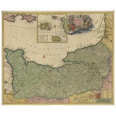
Map of Brittany and Western France by Gerard Valk, circa 1690
770 €IVA incluido
Envío
Recuperando presupuesto…La promesa de 1stDibs
Garantía de autenticidad,
Garantía de devolución de dinero,
Cancelación dentro de las 24 horas
Acerca del artículo
Map of Brittany and Western France by Gerard Valk, circa 1700
This finely detailed antique map, titled *Praefectura Ducatus Britanniae, Quae Superior et Inferior*, was created around 1700 by the Dutch cartographer Gerard Valk. It presents an expansive view of the Duchy of Brittany (Bretagne), historically one of the most culturally distinct and politically significant regions of France. The map reaches eastward to include major cities such as Nantes, Rennes, and Saint-Malo, showing the full extent of both Upper and Lower Brittany.
Gerard Valk (1652–1726) was a prominent mapmaker and globe manufacturer based in Amsterdam. He collaborated with Pieter Schenk and other leading Dutch engravers to publish a number of influential atlases and wall maps. Valk’s maps are known for their clarity, strong engraving technique, and elegant color schemes, and they remain highly desirable among collectors of early cartography.
This particular map displays the western peninsula of France in striking detail, with its rugged coastlines along the Atlantic Ocean, islands such as Belle-Île, and extensive inland geography. Administrative divisions are outlined in yellow and pink hand-coloring, clearly marking the boundaries of ecclesiastical and civil jurisdictions. Towns, rivers, forests, and roadways are all carefully engraved, creating a layered and accurate representation of the region as it stood at the dawn of the 18th century.
The map includes references to bishoprics and archbishoprics, underlining the strong ecclesiastical structure of the region. Its Latin title and classical labeling reflect the scholarly nature of maps in this period, serving both practical and educational purposes.
As a historical object, this map captures a time just before the unification and modernization of the French administrative system. Brittany still retained elements of its medieval autonomy and cultural identity, especially through its language, customs, and religious institutions.
Condition summary:
Good condition with original hand-coloring. Centerfold as issued. Slight toning at edges, but overall crisp and well-preserved. Strong paper.
Framing tips:
Best suited for a gold or dark wood frame with a warm off-white or ivory mat. This will enhance the classical feel and draw out the color contrast. Use museum glass to preserve the detail and reduce glare.
- Dimensiones:Altura: 51,7 cm (20,36 in)Anchura: 60,5 cm (23,82 in)Profundidad: 0,2 mm (0,01 in)
- Materiales y técnicas:Papel,Grabado
- Lugar de origen:
- Época:finales del siglo XVII
- Fecha de fabricación:circa 1690
- Estado:Good condition with original hand-coloring. Centerfold as issued. Slight toning at edges, but overall crisp and well-preserved. Strong paper.
- Ubicación del vendedor:Langweer, NL
- Número de referencia:Vendedor: BG-13732-61stDibs: LU3054345364142
Sobre el vendedor
5,0
Vendedor reconocido
Estos prestigiosos vendedores son líderes del sector y representan el escalón más alto en cuanto a calidad y diseño de artículos.
Vendedor Platino
Vendedores premium con una calificación de +4,7 y tiempos de respuesta de 24 horas
Establecido en 2009
Vendedor de 1stDibs desde 2017
2502 ventas en 1stDibs
Tiempo de respuesta usual: <1 hora
- EnvíoRecuperando presupuesto…Envío desde: Langweer, Países Bajos
- Política de devolución
Partes de esta página se han traducido automáticamente. 1stDibs no puede garantizar la exactitud de las traducciones. El inglés es el idioma predeterminado de este sitio web.
Garantía de autenticidad
En el improbable caso de que haya algún problema con la autenticidad de un artículo, ponte en contacto con nosotros en un plazo de 1 año para recibir un reembolso total. DetallesGarantía de devolución de dinero
Si tu artículo no es como se describe, sufre daños durante el transporte o no llega, ponte en contacto con nosotros en un plazo de 7 días para recibir un reembolso total. DetallesCancelación dentro de las 24 horas
Tienes un período de gracia de 24 horas para reconsiderar tu compra, sin preguntas.Vendedores profesionales aprobados
Nuestros vendedores de primera clase deben cumplir estrictos estándares de servicio para mantener la integridad de nuestros anuncios.Garantía de igualación de precios
Si encuentras que un vendedor publicó el mismo artículo por un precio menor en otro lado, igualaremos ese precio.Entrega global de confianza
Nuestra red de transporte de primera ofrece opciones de envío especializado en todo el mundo, que incluye envío personalizado.Más de este vendedor
Ver todoRaro mapa coloreado a mano de Lorena y Barrois, Francia, por Frederik De Wit c. 1688
Título: Raro mapa coloreado a mano de Lorena y Barrois por Frederik De Wit c. 1688
Descripción: Este notable mapa del siglo XVII, titulado "Generalis Lotharingiae Ducatus", ofrece u...
Categoría
Antiguo, Década de 1680, Mapas
Materiales
Papel

Precioso mapa del siglo XVII de París y la Isla de Francia por Templeux, c.1650
Mapa de la Isla de Francia por D. de Templeux, hacia 1650, coloreado a mano y decorativo
Este mapa antiguo ricamente detallado titulado *Le Gouvernement de L'Isle de France* fue gra...
Categoría
Antiguo, Década de 1650, Mapas
Materiales
Papel

Mapa original de Normandía de Frederick de Wit, 1705, con inserción de las Islas Anglonormandas
Mapa de Normandía de Frederick de Wit, 1705, con inserción de las Islas Anglonormandas
Descripción:
Este mapa bellamente grabado y coloreado a mano, titulado Duché et Gouvernement G...
Categoría
Antiguo, Principios del 1700, Mapas
Materiales
Papel
Mapa antiguo de Francia por Tirion, c.1740
Mapa antiguo titulado 'Nieuwe Kaart van Frankryk'. - Atractivo mapa detallado de Francia. Título en cartela en forma de bloque con una sencilla rosa de los vientos. Fuente desconocid...
Categoría
Antiguo, siglo XVIII, Mapas
Materiales
Papel
360 € Precio de venta
Descuento del 20 %
Impresionante mapa coloreado a mano de Languedoc en Francia por Frederik De Wit c. 1688
Título: Impresionante mapa coloreado a mano de Languedoc por Frederik De Wit c. 1688
Descripción: Este elegante mapa del siglo XVII, "Gouvernement General de Languedoc", ilustra bel...
Categoría
Antiguo, Década de 1680, Mapas
Materiales
Papel
Mapa antiguo de Francia por Mortier 'c.1730'
Mapa antiguo titulado "Galliae Antiquae Tabula". Mapa antiguo original de Francia en la antigüedad. Publicado por P. Mortier, hacia 1730.
Categoría
Antiguo, mediados del siglo XVIII, Mapas
Materiales
Papel

900 € Precio de venta
Descuento del 25 %
También te puede gustar
La región francesa de Normandía: Mapa coloreado a mano del siglo XVII por Sanson y Jaillot
Por Nicolas Sanson
Este gran mapa coloreado a mano titulado "Le Duché et Gouvernement de Normandie divisée en Haute et Basse Normandie en divers Pays; et par evêchez, avec le Gouvernement General du Ha...
Categoría
Antiguo, Década de 1690, Francés, Mapas
Materiales
Papel

1640 Joan Bleau Mapa titulado "Diocecese de rheims et le pais de rethel, " Eic.a011
1640 Mapa de Joan Bleau titulado
"Diocecese de rheims et le pais de rethel".
Ric.a011
OAN BLAEU
Diocecese de Reims, et le pais de Rethel.
Grabado coloreado a mano, c.1...
Categoría
Antiguo, siglo XVII, Holandés, Mapas
Materiales
Papel

1752 Vaugoundy Mapa de Flandes : Bélgica, Francia y Países Bajos, Ric.a002
Gran Mapa Vaugoundy de Flandes:
Bélgica, Francia y Países Bajos
En color -1752
Ric.a002
Descripción: Se trata de un mapa de Flandes de Didier Robert de Vaugondy de 1752. El m...
Categoría
Antiguo, siglo XVII, Desconocido, Mapas
Materiales
Papel

La región francesa de Normandía: Mapa coloreado a mano del siglo XVII por Sanson y Jaillot
Por Nicholas Sanson d'Abbeville
Este gran mapa coloreado a mano titulado "Le Duché et Gouvernement de Normandie divisée en Haute et Basse Normandie en divers Pays; et par evêchez, avec le Gouvernement General du Ha...
Categoría
Década de 1690, Impresiones de paisajes
Materiales
Grabado

Mapa de Bonne de 1771 de Poitou, Touraine y Anjou, Francia, Ric.a015
1771 Bonne Map de Poitou,
Touraine y Anjou, Francia
Ric.a015
1771 Bonne mapa de Potiou, Touraine y Anjou titulado "Carte des Gouvernements D'Anjou et du Saumurois, de la Tou...
Categoría
Antiguo, siglo XVII, Desconocido, Mapas
Materiales
Papel

1635 Willem Blaeu Mapa del norte de Francia "Comitatvs Bellovacvm" Ric.a08
Mapa de Willem Blaeu de 1635 del norte de Francia, titulado.
"Comitatvs Bellovacvm Vernacule Beavvais".
Coloreado
Ric.a008
"COMITATVS BELLOVACVM..." Amsterdam: Willem J. Blae...
Categoría
Antiguo, siglo XVII, Desconocido, Mapas
Materiales
Papel
