Artículos similares a Map of Switzerland by Justus Danckerts, Hand-Colored Engraving ca. 1690


¿Quieres más imágenes o vídeos?
Solicita imágenes o vídeos adicionales al vendedor
1 de 11
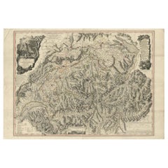
Map of Switzerland by Justus Danckerts, Hand-Colored Engraving ca. 1690
550 €IVA incluido
Acerca del artículo
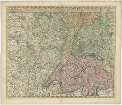
Map of Switzerland by Justus Danckerts, Hand-Colored Engraving ca. 1690
This detailed and attractively hand-colored antique map titled *Helvetiae Rhaetiae et Valesiae, nec non partis Sabaudiae Tabula* was engraved and published by Justus Danckerts in Amsterdam around 1690. It depicts the Swiss Confederacy along with neighboring regions, including Rhaetia (modern Graubünden), Valais, and part of Savoy. This is a quintessential example of late 17th-century Dutch cartography—ornate, richly detailed, and both scientifically useful and visually appealing.
The map is a masterful representation of the geography of the Swiss Alps and surrounding territories. It features major cities such as Zurich, Bern, Basel, Lucerne, and Geneva (Genève), along with an exceptional network of rivers, lakes, mountain ranges, and political boundaries. Lake Geneva (Lemanus Lacus) and parts of the Rhône River system are prominently illustrated.
The regional borders are highlighted in original hand-color, a practice common in maps from this period to distinguish various cantons and territories. In the upper left, a decorative cartouche with scrollwork, draped fabric, and two allegorical figures presents the title. This style of embellishment, with its bold putti and theatrical flair, is characteristic of the Danckerts workshop and helps distinguish this map from earlier works by Blaeu or Janssonius.
Justus Danckerts (1635–1701) came from a renowned family of Dutch mapmakers and publishers. He was part of the third generation of the Danckerts firm and was known for producing high-quality wall maps, atlases, and decorative engravings. His maps were prized for their clarity, vivid hand-coloring, and elegant ornamentation.
This map serves as both a collector’s piece and a decorative artifact of late Dutch Golden Age cartography. It captures a richly detailed vision of Switzerland at a time when it was forming its independent identity in the heart of Europe.
Condition report:
Well-preserved, considering age, but with some edge wear, light age toning, but mostly in the borders. The image itself mostly a clean and detailed sharp impression.
Tips for Framng:
Best framed in dark walnut or gold-leaf wood, with an off-white or pale grey mat to enhance the map’s intricate linework and rich period coloring.
- Dimensiones:Altura: 52 cm (20,48 in)Anchura: 60 cm (23,63 in)Profundidad: 0,02 mm (0 in)
- Materiales y técnicas:Papel,Grabado
- Época:finales del siglo XVII
- Fecha de fabricación:circa 1690
- Estado:Well-preserved, considering age, but with some edge wear, light age toning, but mostly in the borders. The image itself mostly a clean and detailed sharp impression.
- Ubicación del vendedor:Langweer, NL
- Número de referencia:Vendedor: BG-13669-11stDibs: LU3054345364222
Sobre el vendedor
5,0
Vendedor reconocido
Estos prestigiosos vendedores son líderes del sector y representan el escalón más alto en cuanto a calidad y diseño de artículos.
Vendedor Platino
Vendedores premium con una calificación de +4,7 y tiempos de respuesta de 24 horas
Establecido en 2009
Vendedor de 1stDibs desde 2017
2531 ventas en 1stDibs
Tiempo de respuesta usual: <1 hora
- EnvíoRecuperando presupuesto…Envío desde: Langweer, Países Bajos
- Política de devolución
Partes de esta página se han traducido automáticamente. 1stDibs no puede garantizar la exactitud de las traducciones. El inglés es el idioma predeterminado de este sitio web.
Garantía de autenticidad
En el improbable caso de que haya algún problema con la autenticidad de un artículo, ponte en contacto con nosotros en un plazo de 1 año para recibir un reembolso total. DetallesGarantía de devolución de dinero
Si tu artículo no es como se describe, sufre daños durante el transporte o no llega, ponte en contacto con nosotros en un plazo de 7 días para recibir un reembolso total. DetallesCancelación dentro de las 24 horas
Tienes un período de gracia de 24 horas para reconsiderar tu compra, sin preguntas.Vendedores profesionales aprobados
Nuestros vendedores de primera clase deben cumplir estrictos estándares de servicio para mantener la integridad de nuestros anuncios.Garantía de igualación de precios
Si encuentras que un vendedor publicó el mismo artículo por un precio menor en otro lado, igualaremos ese precio.Entrega global de confianza
Nuestra red de transporte de primera ofrece opciones de envío especializado en todo el mundo, que incluye envío personalizado.Más de este vendedor
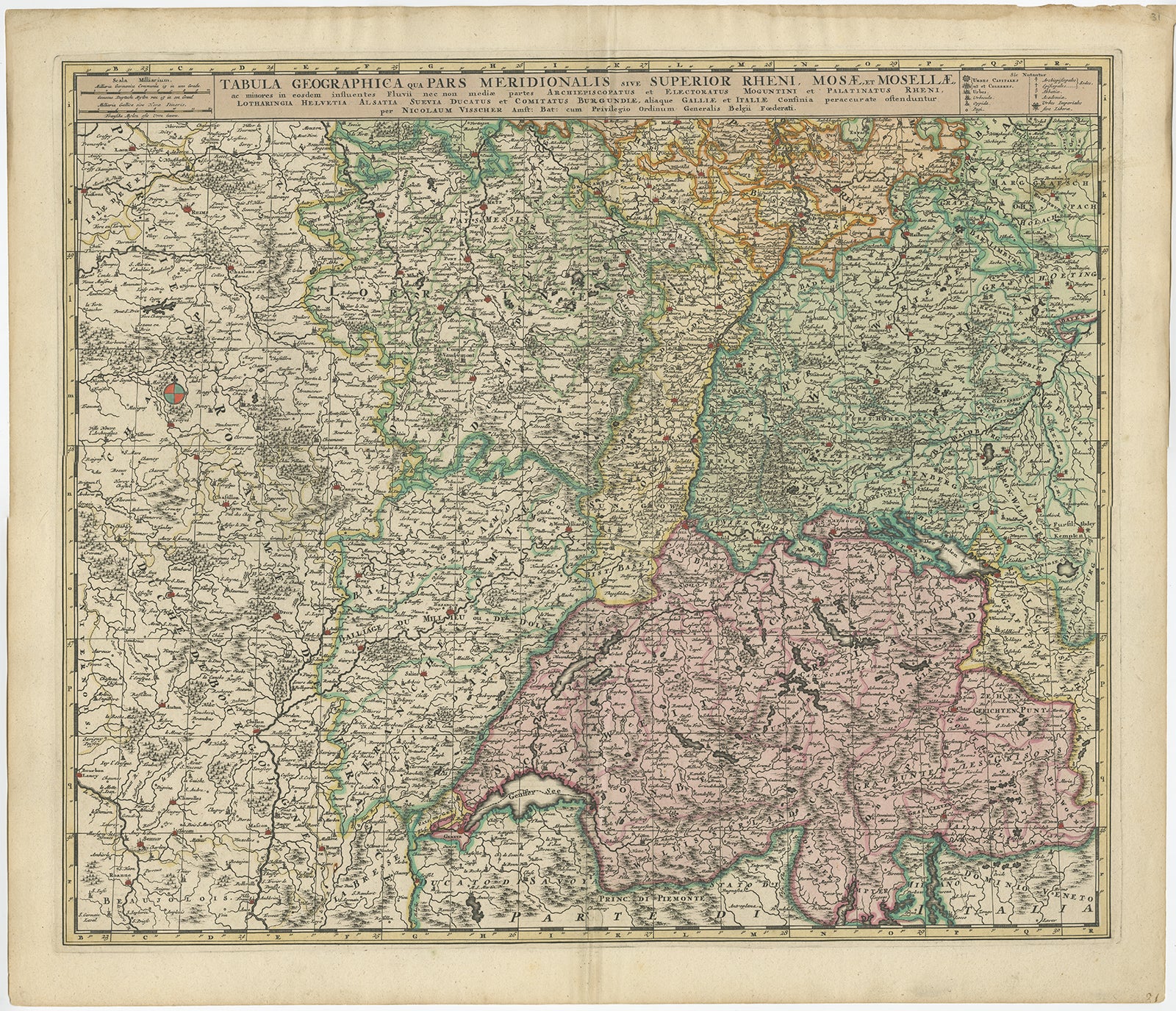
Ver todoMapa antiguo de Suiza por N. Visscher, hacia 1690
Mapa antiguo titulado "Tabula Geogaphica qua Pars Meridionalis sive Superior Rheni, Mosae, et Mosellae (..)". Publicado por N. Visscher, Amsterdam, hacia 1690. Coloración contemporánea.
Categoría
Antiguo, finales del siglo XVII, Mapas
Materiales
Papel
532 € Precio de venta
Descuento del 20 %
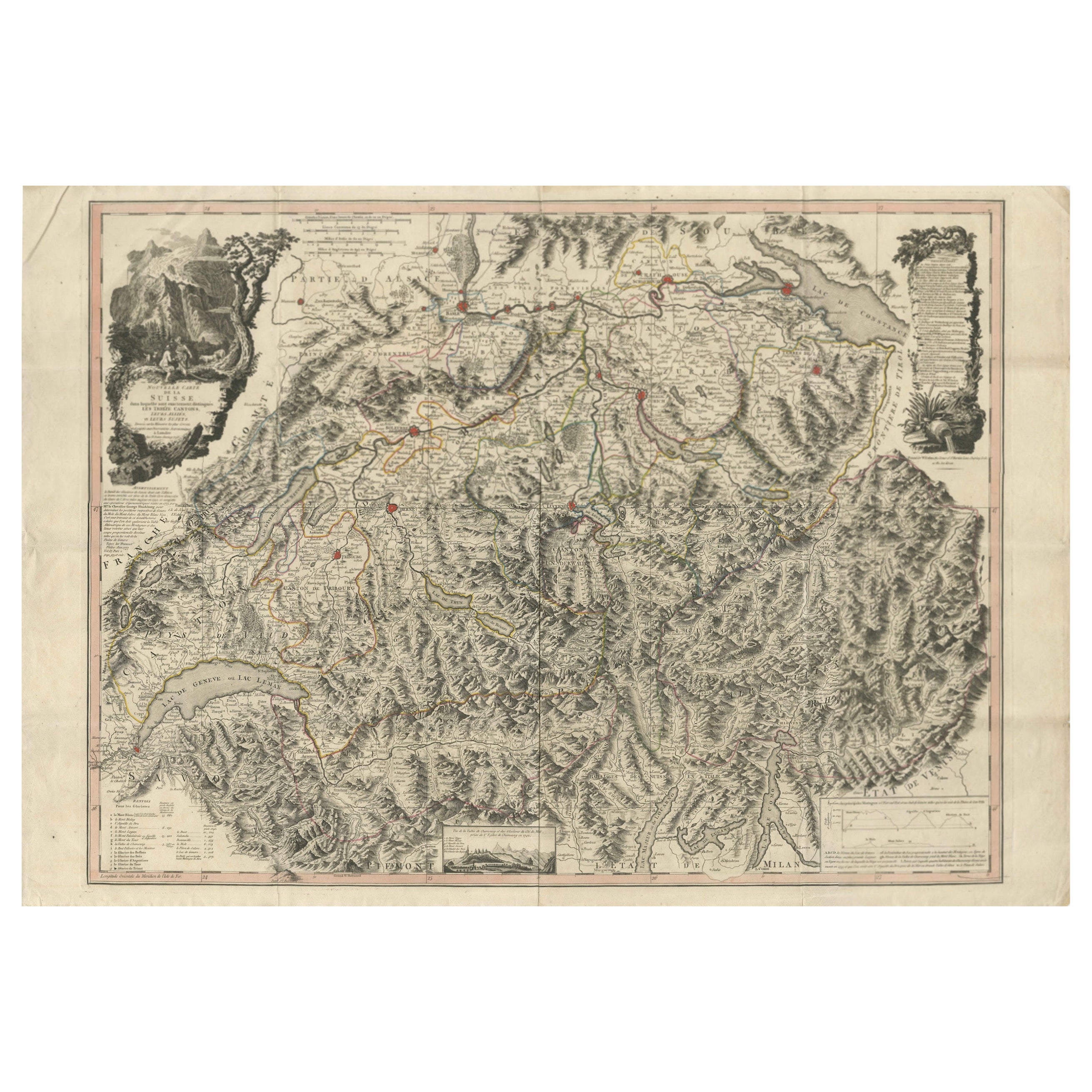
Mapa de Suiza 1778 - Llamativa lámina de cobre coloreada a mano de los trece cantones
Switzerland Map 1778 – Faden’s Hand-Colored Copperplate of the Thirteen Cantons
This striking copperplate engraving, published by William Faden in London in 1778, offers a detailed ...
Categoría
Antiguo, finales del siglo XVIII, Europeo, Mapas
Materiales
Papel
Mapa antiguo de Suiza por J.B. Homann, 1751
Por Johann Baptist Homann
Ejemplar decorativo del mapa de Suiza de Homann, con cartela decorativa y el escudo de armas de cada uno de los 13 cantones.
Categoría
Antiguo, mediados del siglo XVIII, Mapas
Materiales
Papel

472 € Precio de venta
Descuento del 20 %
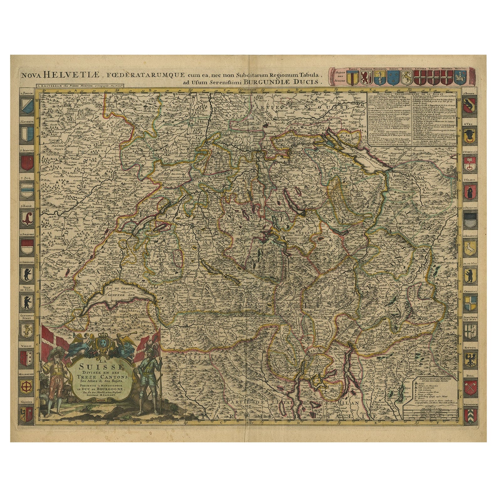
Precioso mapa antiguo coloreado a mano de Suiza con 33 escudos de armas, ca.1705
Mapa antiguo de Suiza titulado "La Suisse Divisee en ses Treze Cantons, ses Alliez & ses Sujets (..)".
Precioso mapa de Suiza con 33 escudos de armas. El mapa está dedicado al duqu...
Categoría
Antiguo, Principios del 1700, Mapas
Materiales
Papel
1280 € Precio de venta
Descuento del 20 %
Envío gratuito
Mapa antiguo de Suiza por Keizer & de Lat, 1788
Mapa antiguo titulado 'La Suisse (..)'. Mapa antiguo original poco común de Suiza. Este mapa procede del "Nieuwe Natuur- Geschied- en Handelkundige Zak- en Reisatlas" de Gerrit Brend...
Categoría
Antiguo, finales del siglo XVIII, Mapas
Materiales
Papel

280 € Precio de venta
Descuento del 20 %
Mapa antiguo de Suiza por Homann Heirs, c.1732
Mapa antiguo titulado "Potentissimae Helvetiorum Reipublicae (..)". Precioso mapa detallado de Suiza, con los 13 cantones. La gran cartela del título muestra 13 escudos de armas de l...
Categoría
Antiguo, siglo XVIII, Mapas
Materiales
Papel

314 € Precio de venta
Descuento del 20 %
También te puede gustar
Mapa de Suiza - Aguafuerte - Siglo XIX
Este mapa de Holanda es un aguafuerte realizado en el siglo XIX.
El estado de conservación de las obras de arte es excelente. La firma "F.B." está grabada en la parte inferior derec...
Categoría
siglo XIX, Impresiones figurativas
Materiales
Grabado químico

Mapa original antiguo de Suiza, grabado por Barlow, fechado en 1807
Gran mapa de Suiza
Grabado en plancha de cobre de Barlow
Publicado por Brightly & Kinnersly, Bungay, Suffolk.
Fechado en 1807
Sin enmarcar.
Categoría
Antiguo, Principios del 1800, Inglés, Mapas
Materiales
Papel

Mapa Homann de Austria del siglo XVIII coloreado a mano que incluye Viena y el Danubio
Por Johann Baptist Homann
"Archiducatus Austriae inferioris" es un mapa coloreado a mano de Austria creado por Johann Baptist Homann (1663-1724) y publicado en Nuremberg, Alemania, en 1728, poco después de su...
Categoría
principios del siglo XVIII, Antiguos maestros, Impresiones de paisajes
Materiales
Grabado

Alemania Occidental: Mapa original del siglo XVII coloreado a mano por Johannes Janssonius
Por Johannes Janssonius
Mapa original grabado en cobre coloreado a mano, titulado en latín "Archiepiscopatus Maghdeburgensis et Anhaltinus Ducatus cum terris adjacentibus", publicado en Amsterdam en 1640 en...
Categoría
mediados del siglo XVII, Antiguos maestros, Más impresiones
Materiales
Grabado

1571-1638 Mapa de Willem Blaeu titulado "Ilcadorino", coloreado a mano Ric0009
Mapa Willem Blaeu titulado,
"Ilcadorino".
Coloreado a mano.
Descripción: gran mapa antiguo de Ilcadorino, inusual y bonito, grabado en cobre, por Willem BLAEU (1571-1638), sig...
Categoría
Antiguo, siglo XVI, Holandés, Mapas
Materiales
Papel

Mapa de la Guerra -Vesfaglia y Baja Sajonia - Aguafuerte - Siglo XIX
Mapa de la Guerra -Vestaglia y Baja Sajonia es un grabado realizado durante el siglo XIX.
Buen estado.
Categoría
principios del siglo XIX, Moderno, Impresiones figurativas
Materiales
Grabado químico
