Artículos similares a Mapa antiguo de Hungría y Transilvania por Isaak Tirion, Amsterdam c.1740


Cargando vídeo
¿Quieres más imágenes o vídeos?
Solicita imágenes o vídeos adicionales al vendedor
1 de 11
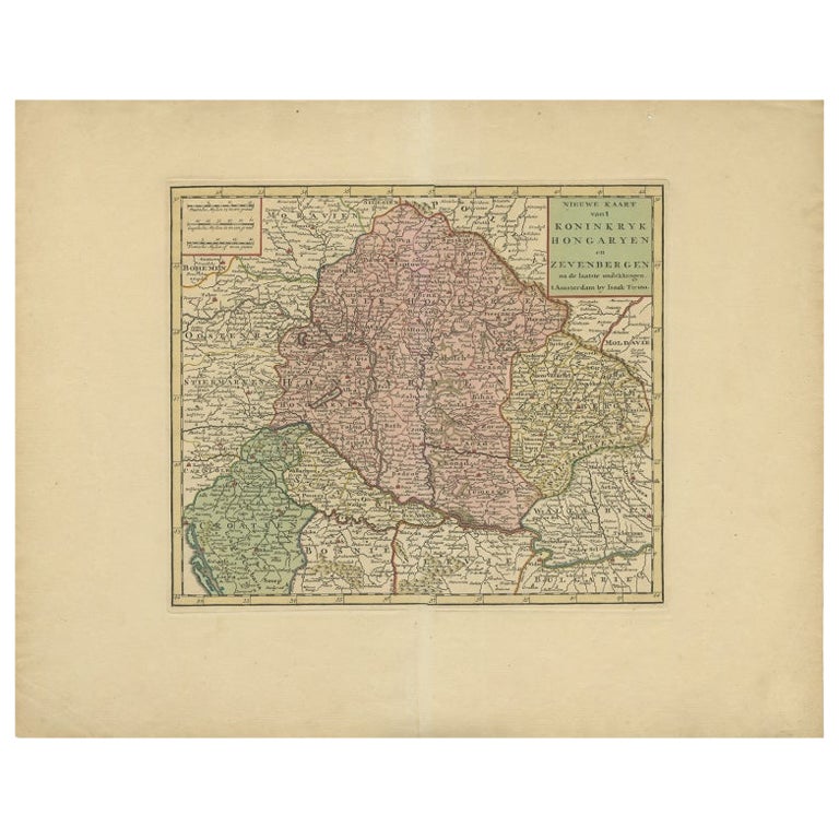
Mapa antiguo de Hungría y Transilvania por Isaak Tirion, Amsterdam c.1740
590 €IVA incluido
Acerca del artículo
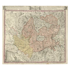
Poland Map 1740s – Nieuwe Kaart van het Koninryk Poolen by Isaak Tirion
This finely engraved and attractively hand-colored map of the Kingdom of Poland was published by Isaak Tirion in Amsterdam in the mid-18th century, likely around the 1740s. Titled in Dutch as 'Nieuwe Kaart van het Koninryk Poolen', the map presents an accurate and beautifully detailed rendering of Poland and its constituent voivodeships (Way-woodschaappen), as they existed prior to the partitions that would later redefine the region.
The map shows the eastern territories of the Polish–Lithuanian Commonwealth, including areas of modern-day Poland, Lithuania, Belarus, and western Ukraine. Political boundaries are clearly delineated in original outline color, with provinces shaded in soft pastels—pink, green, yellow, and blue—allowing the viewer to distinguish between major regions such as Lithuania, Mazovia, and Podolia. The map is densely engraved with towns, rivers, mountain ranges, and forests, reflecting the high standard of geographic accuracy for which Tirion was renowned.
The title cartouche in the upper left corner is both informative and elegant, printed in Dutch and emphasizing the map’s reliability and use of the latest sources available at the time. Isaak Tirion (1705–1765) was a prominent Amsterdam-based publisher whose atlases and historical works remain prized for their craftsmanship and clarity. This map appeared in his 'Hedendaagsche Historie' or 'Nieuwe en Beknopte Hand-Atlas'.
Condition:
This antique map is in very good condition with wide margins, strong plate impression, and fresh original hand color. Very minimal foxing or age toning is visible, and the sheet remains clean and structurally sound. One small hole in the fold. No tears or repairs are present.
Framing Tips:
This historic map is well suited for framing in a simple, narrow black or gold moulding to match its cartographic elegance. A soft cream or pale beige mat will complement the pastel tones while keeping the focus on the detail. Ideal for a study, library, or office, this map is a refined collector’s item for those interested in Polish or Eastern European history.
- Dimensiones:Altura: 41,6 cm (16,38 in)Anchura: 50,5 cm (19,89 in)Profundidad: 0,2 mm (0,01 in)
- Materiales y técnicas:Papel,Grabado
- Lugar de origen:
- Época:
- Fecha de fabricación:circa 1740
- Estado:This antique map is in very good condition with wide margins, strong plate impression, and fresh original hand color. Very minimal foxing or age toning is visible, and the sheet remains clean and structurally sound. One small hole in the fold.
- Ubicación del vendedor:Langweer, NL
- Número de referencia:Vendedor: BG-14031-41stDibs: LU3054345438252
Sobre el vendedor
5,0
Vendedor reconocido
Estos prestigiosos vendedores son líderes del sector y representan el escalón más alto en cuanto a calidad y diseño de artículos.
Vendedor Platino
Vendedores premium con una calificación de +4,7 y tiempos de respuesta de 24 horas
Establecido en 2009
Vendedor de 1stDibs desde 2017
2567 ventas en 1stDibs
Tiempo de respuesta usual: <1 hora
- EnvíoRecuperando presupuesto…Envío desde: Langweer, Países Bajos
- Política de devolución
Partes de esta página se han traducido automáticamente. 1stDibs no puede garantizar la exactitud de las traducciones. El inglés es el idioma predeterminado de este sitio web.
Garantía de autenticidad
En el improbable caso de que haya algún problema con la autenticidad de un artículo, ponte en contacto con nosotros en un plazo de 1 año para recibir un reembolso total. DetallesGarantía de devolución de dinero
Si tu artículo no es como se describe, sufre daños durante el transporte o no llega, ponte en contacto con nosotros en un plazo de 7 días para recibir un reembolso total. DetallesCancelación dentro de las 24 horas
Tienes un período de gracia de 24 horas para reconsiderar tu compra, sin preguntas.Vendedores profesionales aprobados
Nuestros vendedores de primera clase deben cumplir estrictos estándares de servicio para mantener la integridad de nuestros anuncios.Garantía de igualación de precios
Si encuentras que un vendedor publicó el mismo artículo por un precio menor en otro lado, igualaremos ese precio.Entrega global de confianza
Nuestra red de transporte de primera ofrece opciones de envío especializado en todo el mundo, que incluye envío personalizado.Más de este vendedor
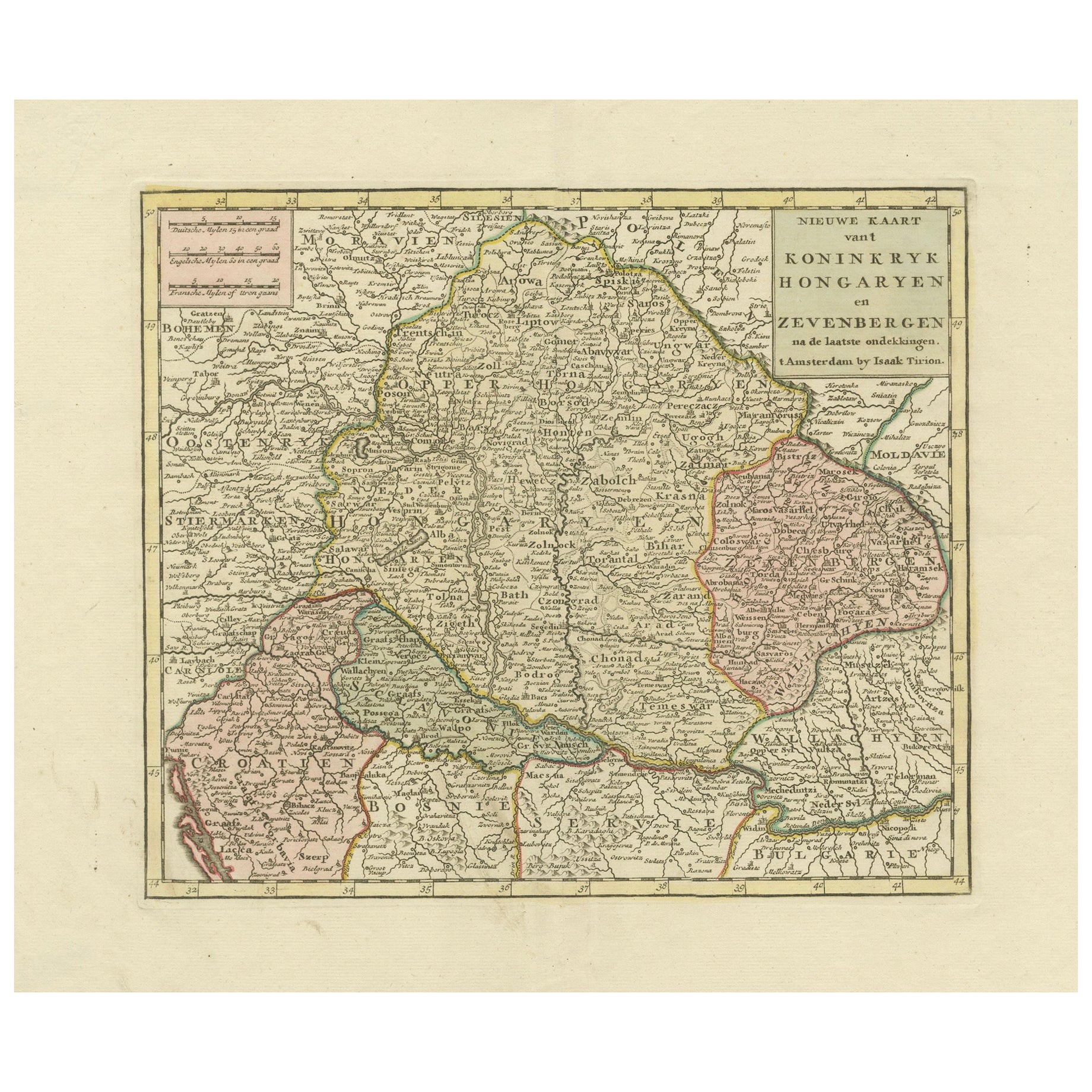
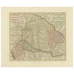
Ver todoMapa antiguo de Hungría, incluidos sus alrededores, como Croacia, Bosnia y Servia, 1730
Mapa antiguo titulado "Nieuwe Kaart van t Koninkryk Hongaryen en Zevenbergen na de laatste ontdekkingen".
Este mapa representa Hungría, incluidos sus alrededores como Croacia, Bosn...
Categoría
Antiguo, siglo XVIII, Mapas
Materiales
Papel

440 € Precio de venta
Descuento del 20 %
Mapa antiguo detallado de Hungría y Transilvania por Tirion, 1753
Título: Nieuwe Kaart van't Koninkryk Hongaryen en Zevenbergen de Isaak Tirion, 1753 - Mapa antiguo de Hungría y Transilvania
Descripción: Se trata de un mapa antiguo de 1753 titul...
Categoría
Antiguo, Década de 1750, Mapas
Materiales
Papel
483 € Precio de venta
Descuento del 30 %
Mapa antiguo del Reino de Hungría por Keizer & de Lat, 1788
Mapa antiguo titulado "t Koninkryk Hongarien (..)". Mapa antiguo original poco común del Reino de Hungría. Este mapa procede del "Nieuwe Natuur- Geschied- en Handelkundige Zak- en Re...
Categoría
Antiguo, finales del siglo XVIII, Mapas
Materiales
Papel

280 € Precio de venta
Descuento del 20 %
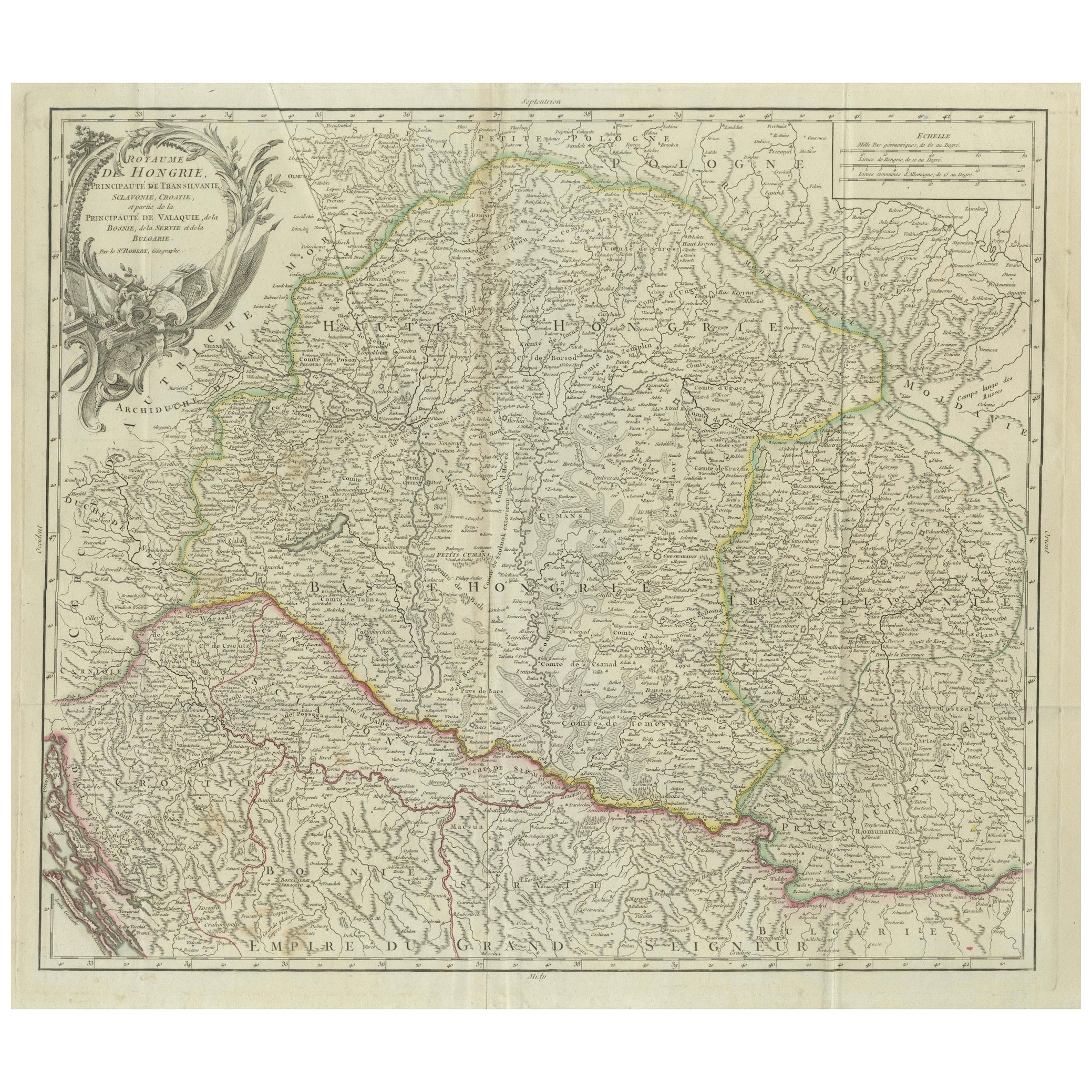
Mapa antiguo del Reino de Hungría y Transilvania, hacia 1780
Mapa antiguo del Reino de Hungría y regiones circundantes por S. Robert, hacia 1780
Este bello mapa grabado titulado Royaume de Hongrie, Principauté de Transilvanie, Esclavonie, Cro...
Categoría
Antiguo, finales del siglo XVIII, Francés, Mapas
Materiales
Papel

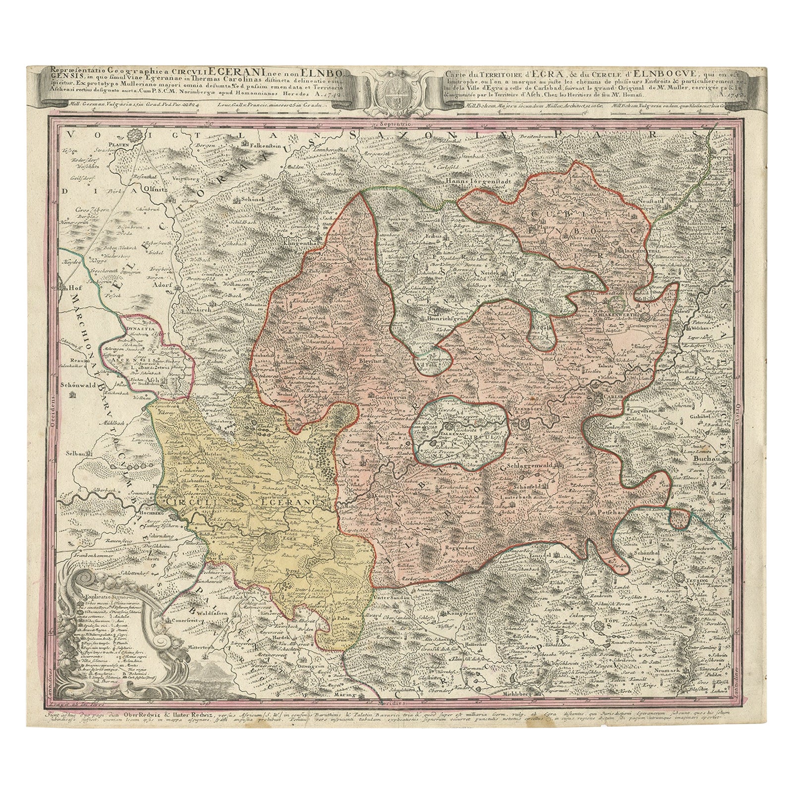
Mapa antiguo de la región de Elbogen y Eger, República Checa y Hungría, 1742
Mapa antiguo titulado "Repraesentatio Geographica Circuli Egerani, nec non Elnbogensis : in quo simul viae Egeranae in Thermas Carolinas distincta delineatio conspicitur (..)".
M...
Categoría
Antiguo, Década de 1740, Mapas
Materiales
Papel
432 € Precio de venta
Descuento del 20 %
Mapa antiguo de Austria por F. de Wit, 1690
Mapa antiguo titulado "Circuli Austriaci pars Septentrionalis in qua Archiducatus". Mapa decorativo y detallado de Austria por F. de Wit.
Categoría
Antiguo, finales del siglo XVII, Mapas
Materiales
Papel

También te puede gustar
Mapa original antiguo de Hungría, Arrowsmith, 1820
Gran mapa de Hungría
Dibujado bajo la dirección de Arrowsmith.
Grabado en plancha de cobre.
Publicado por Longman, Hurst, Rees, Orme, & Brown, 1820
Sin enmarcar.
Categoría
Antiguo, Década de 1820, Inglés, Mapas
Materiales
Papel

Mapa de Thomas Stackhouse de 1790, titulado "Rusia en Europa", Ric.a004
Mapa de Thomas Stackhouse de 1790, titulado
"Rusia en Europa"
Ric.a004
Stackhouse, Thomas
Rusia en Europa [mapa]
Londres: T. Stackhouse, 1783. Mapa. Grabado en cobre colorea...
Categoría
Antiguo, siglo XVII, Desconocido, Mapas
Materiales
Papel

1752 Vaugoundy Mapa de Flandes : Bélgica, Francia y Países Bajos, Ric.a002
Gran Mapa Vaugoundy de Flandes:
Bélgica, Francia y Países Bajos
En color -1752
Ric.a002
Descripción: Se trata de un mapa de Flandes de Didier Robert de Vaugondy de 1752. El m...
Categoría
Antiguo, siglo XVII, Desconocido, Mapas
Materiales
Papel

1849 Mapa de "Europaische Russland", 'Mapa Meyer de la Rusia europea', Ric. R017
1849 Mapa de
"La Rusia europea"
( Mapa de Meyer de la Rusia europea)
Ric.r017
Precioso mapa de la Rusia europea de 1849, obra de Joseph Meyer. Abarca las partes europeas de R...
Categoría
Antiguo, siglo XIX, Desconocido, Mapas
Materiales
Papel

1839 Mapa de Karte Des "Russischen Reiches in Europa Und Asien" Ric.R0013
Mapa de 1839 de Karte Des
"Los Reinos Rusos en Europa y Asia"
Ric.r013
Mapa de las partes europea y asiática del Imperio Ruso. Mapa de los Reinos Rusos en Europa y Asia. 1tes ...
Categoría
Antiguo, siglo XIX, Desconocido, Mapas
Materiales
Papel

1853 Mapa de "Rusia en Europa, incluida Polonia" Ric.r016
Descripción
Rusia en Europa incl. Polonia por J. Wyld c.1853
Grabado en acero coloreado a mano
Dimensión: Papel: 25 cm An x 33 cm Al ; Vista: 22 cm An x 28 cm Al
Estado...
Categoría
Antiguo, siglo XIX, Desconocido, Mapas
Materiales
Papel
