Articles similaires à Cartography Print 1852 – Educational Diagram of Mountains, Winds, and Reefs


Vous voulez plus d'images ou de vidéos ?
Demander au vendeur plus d'images ou de vidéos
1 sur 9
Cartography Print 1852 – Educational Diagram of Mountains, Winds, and Reefs
240 €par article|TVA incluse
Quantité
Expédition
Recherche du devis...La promesse 1stDibs :
Garantie d'authenticité,
Garantie de remboursement,
Annulation sous 24 heures
À propos de cet article
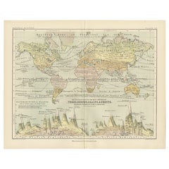
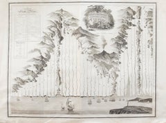
Cartographic Masterpiece 1852 – Illustrated Guide to Map Symbols and Climate
Description:
This original 1852 plate titled "Illustrations of Chartography Plate I" offers a fascinating and visually rich introduction to 19th-century mapping techniques. Published in A School Atlas of Physical Geography by the eminent Scottish cartographer Alexander Keith Johnston, the plate served as an educational tool designed to teach the principles of cartography, climatology, geology, and meteorology.
The detailed engravings include symbolic representations used on maps, such as forms of mountains, volcanoes, reef systems, and rainfall diagrams, along with charts of wind directions, cloud formations, and the system of contouring. Particularly notable is the lower section titled "Climatography," which combines scientific elements into a picturesque landscape featuring a rainbow, tornado, sea spray, and a mountain chain—all stylized to represent the natural forces shaping Earth’s surface.
Johnston was a leading cartographer of the Victorian period, and this atlas was used widely in schools and scientific circles for its clarity and innovative visual methods. The plate was engraved and printed by W. & A.K. Johnston, his family firm, which gained a global reputation for excellence in educational publishing.
This chart is not only historically significant but also aesthetically appealing, making it an ideal piece for collectors of antique scientific prints or for elegant interior decoration with an academic flair.
Condition:
Very good antique condition. Clean impression with light age-toning and minimal foxing. Edges show only minor wear. Fold in middle as issued. Suitable for immediate display or archival framing.
Tips for Framing:
Mat in light ivory or soft taupe to highlight the warm aged tones. Use a slim black or walnut wood frame for a classic scientific look that pairs well with academic or minimalist interiors.
- Dimensions:Hauteur : 27,4 cm (10,79 po)Largeur : 34,5 cm (13,59 po)Profondeur : 0,2 mm (0,01 po)
- Matériaux et techniques:
- Période:
- Date de fabrication:1852
- État:Very good antique condition. Clean impression with light age-toning and minimal foxing. Edges show only minor wear. Fold in middle as issued. Suitable for immediate display or archival framing.
- Adresse du vendeur:Langweer, NL
- Numéro de référence:Vendeur : BG-13207-11stDibs : LU3054345370352
À propos du vendeur
5,0
Vendeur reconnu
Ces vendeurs prestigieux sont des leaders du secteur. Ils représentent le summum en matière de qualité et de design.
Vendeur Platine
Vendeurs premium dont la note est supérieure à 4,7 et le délai de réponse de 24 heures maximum
Établi en 2009
Vendeur 1stDibs depuis 2017
2 491 ventes sur 1stDibs
Temps de réponse habituel : <1 heure
- ExpéditionRecherche du devis...Expédition depuis : Langweer, Pays-Bas
- Politique des retours
Certaines parties de cette page ont été traduites automatiquement. 1stDibs ne garantit pas l'exactitude des traductions. L'anglais est la langue par défaut de ce site web.
Garantie d'authenticité
Bien qu'il soit peu probable que la situation se présente, dans le cas où vous rencontreriez un problème d'authenticité d'un article, contactez-nous dans un délai d'un an pour obtenir un remboursement intégral. DétailsGarantie de remboursement
Si votre article n'est pas conforme à la description, est endommagé pendant le transport ou ne vous est pas livré, contactez-nous sous 7 jours pour obtenir un remboursement intégral. DétailsAnnulation sous 24 heures
Vous disposez d'un délai de 24 heures pour annuler votre achat sans motif.Des vendeurs professionnels agréés
Nos vendeurs de renommée mondiale doivent respecter des normes strictes en matière de service et de qualité, afin de préserver l'intégrité de nos fiches produit.Garantie d'alignement des prix
Si vous constatez qu'un autre vendeur a mis en vente le même article à un prix inférieur sur un autre site, nous nous alignerons sur ce prix.Livraison en toute confiance à l'international
Notre réseau de transporteurs de premier ordre propose des options d'expédition spécialisées dans le monde entier, y compris des livraisons personnalisées.Plus d'articles de ce vendeur
Tout afficherWind and Hurricane Map by A.K. Johnston – Meteorological Chart 1852
Wind and Hurricane Map by A.K. Johnston – Meteorological Chart 1852
This scientifically significant 1852 map titled "The Distribution of the Constant, Periodical & Variable Winds Ov...
Catégorie
Antiquités, Milieu du XIXe siècle, Écossais, Estampes
Matériaux
Papier

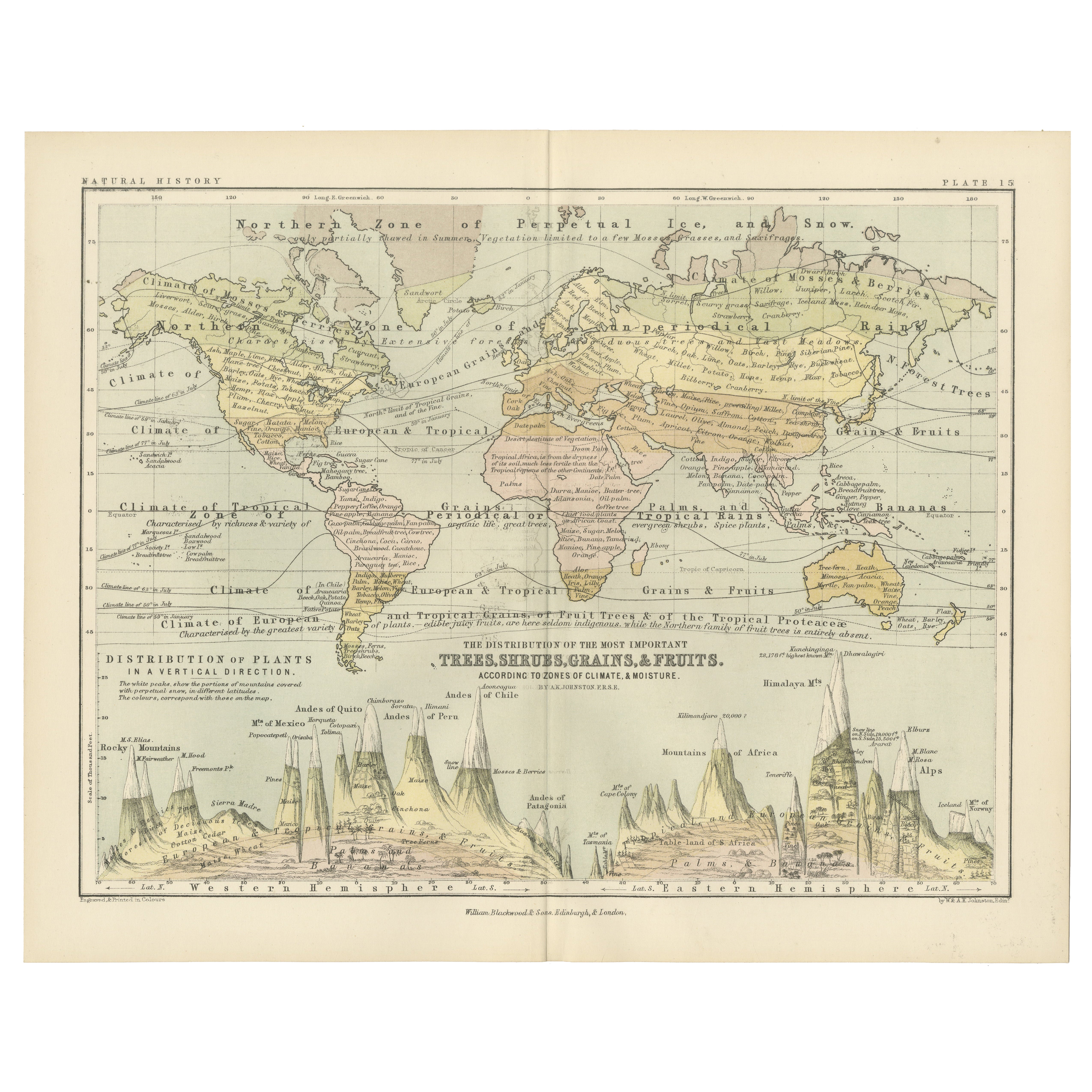
Botanical Map by A.K. Johnston – Global Plant Distribution Chart 1852
Botanical Map by A.K. Johnston – Global Plant Distribution Chart 1852
This remarkable antique chart titled "The Distribution of the Most Important Trees, Shrubs, Grains, & Fruits Ac...
Catégorie
Antiquités, Milieu du XIXe siècle, Écossais, Estampes
Matériaux
Papier
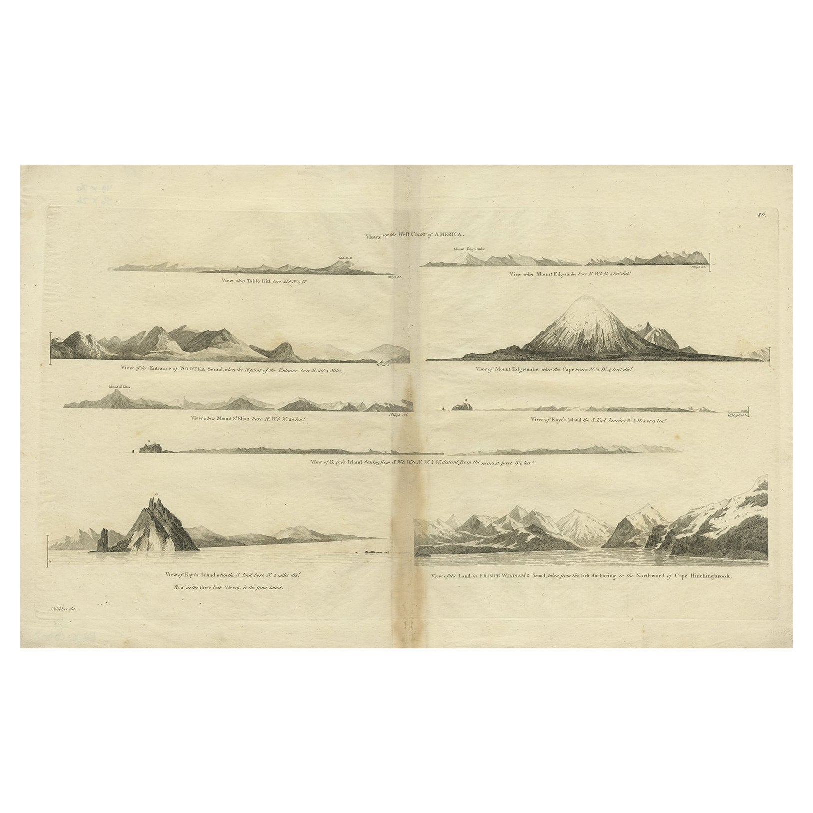
Carte ancienne de la côte ouest de l'Amérique avec des vues d'îles, vers 1784
Gravure ancienne intitulée 'Views on the West Coast of America (...)'.
Vues côtières de diverses îles de la côte américaine. Provient d'une édition des Voyages de Cook.
Artis...
Catégorie
Antiquités, années 1780, Cartes
Matériaux
Papier
360 € Prix de vente
20 % de remise
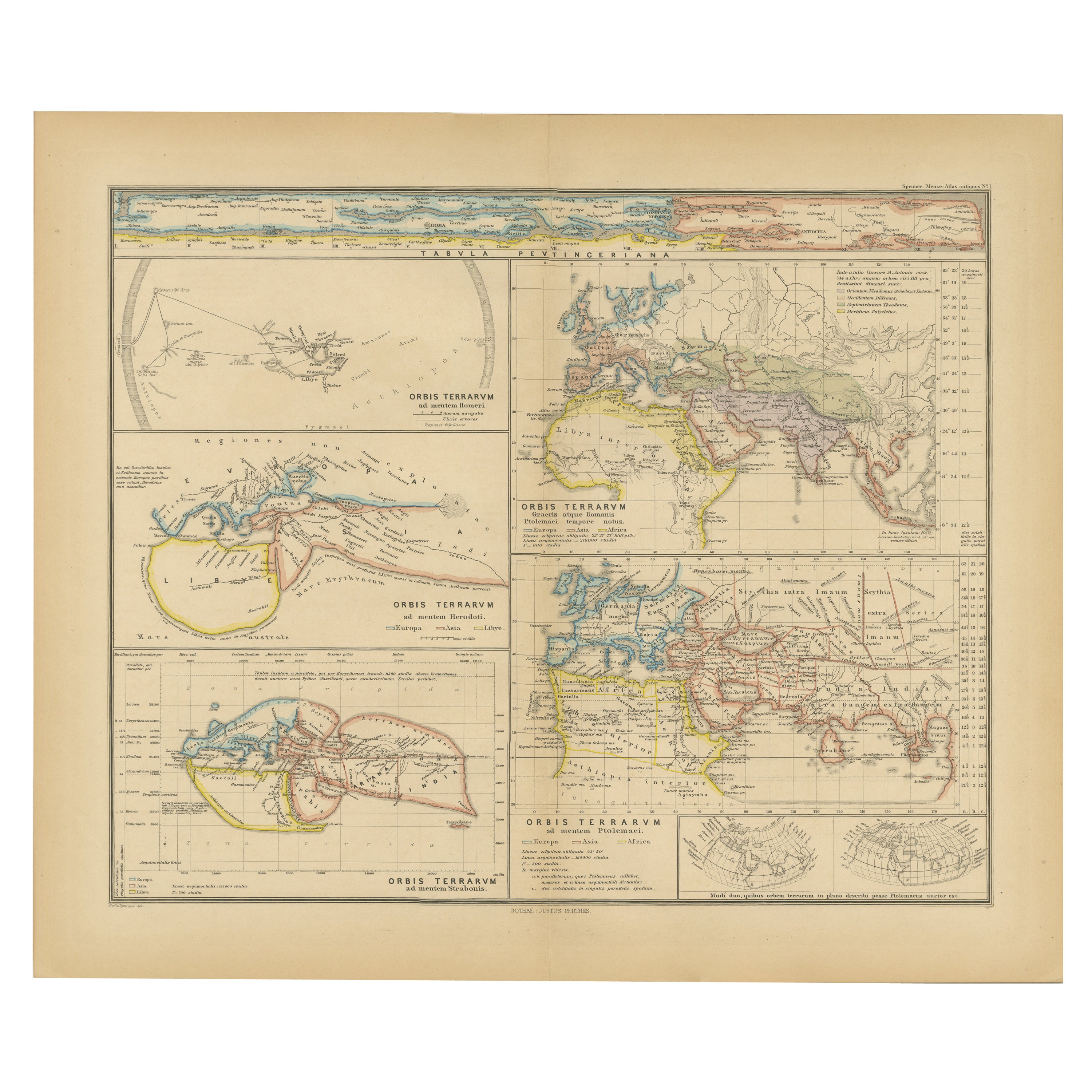
Ancien composite original de plusieurs cartes du monde antique sur une seule feuille, 1880
Cette carte ancienne originale est tirée de l'"Atlas Antiquus" de Karl Spruner von Merz, édité plus tard par Theodorus Menke. La carte est une représentation détaillée du monde antiq...
Catégorie
Antiquités, années 1880, Cartes
Matériaux
Papier
296 € Prix de vente
20 % de remise
Livraison gratuite
Carte ancienne montrant la distribution des plantes par Johnston, '1850'
Carte ancienne intitulée "Distribution géographique des plantes". Carte ancienne originale montrant la répartition des plantes. Cette carte est tirée de "The Physical Atlas of Natura...
Catégorie
Antiquités, Milieu du XIXe siècle, Cartes
Matériaux
Papier

160 € Prix de vente
20 % de remise
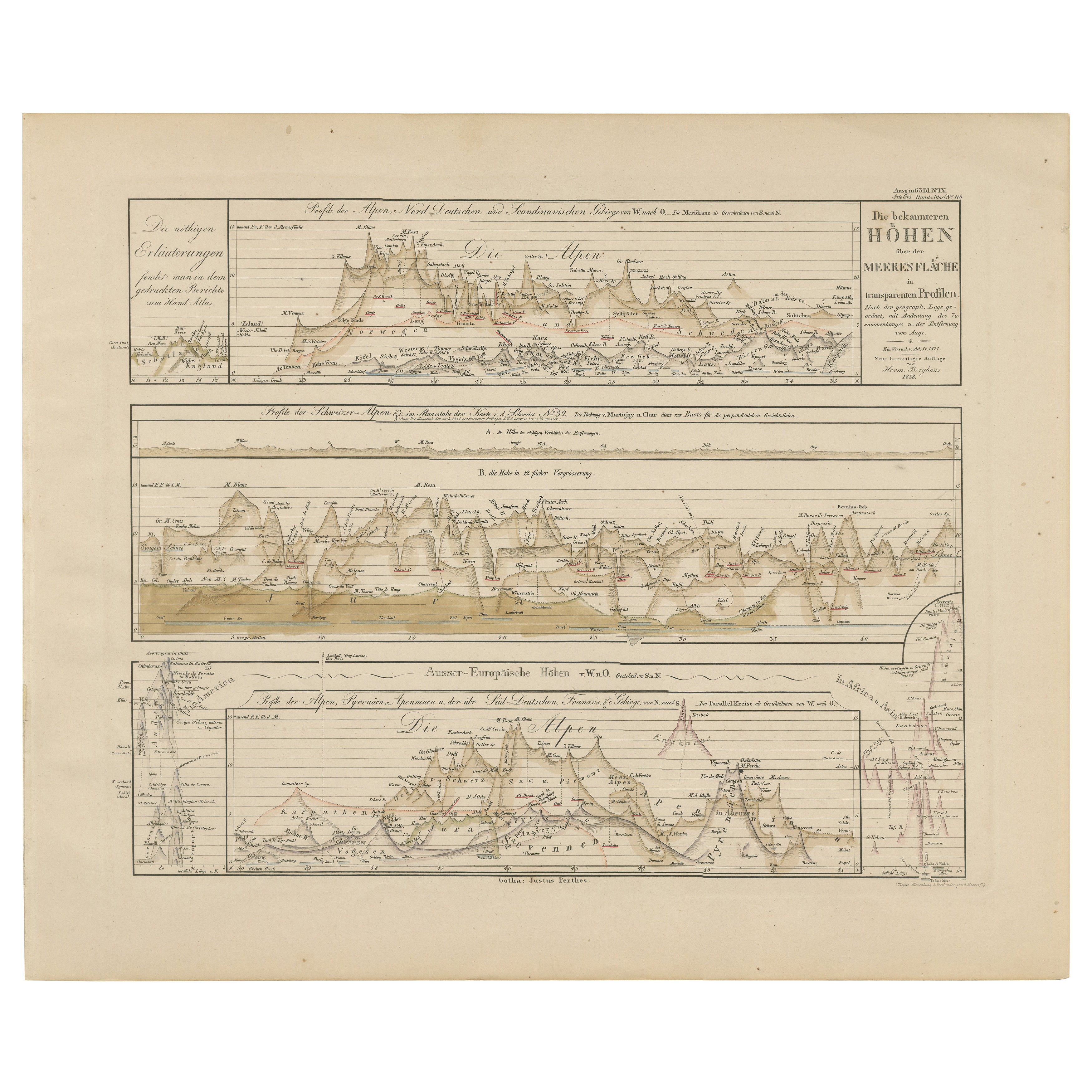
Profils d'altitude des montagnes - Alpes, Pyrénées, Andes et hauteurs du monde 1857
Profils d'altitude des montagnes - Alpes, Pyrénées, Andes et hauteurs du monde 1857
Cette intrigante gravure ancienne montre des profils d'élévation comparatifs intitulés "Die bekan...
Catégorie
Antiquités, Milieu du XIXe siècle, Allemand, Cartes
Matériaux
Papier
Suggestions
Hemisphere Of The New Continent - Ancienne carte de J.G. Heck - 1834.
Par Johann Georg Heck
Hémisphère du Nouveau Continent est une œuvre d'art réalisée vers 1760 par Johann Georg Heck
Tirage original en couleur.
Bon état, à l'exception du jaunissement du papier et des d...
Catégorie
années 1830, Moderne, Estampes - Figuratif
Matériaux
Eau-forte

Carte ancienne représentant toute la surface de la Terre divisée en six parties France 1850
Carte représentant toute la surface de la Terre divisée en six parties et représentant la position des peuples sur la Terre en partant du principe qu'il est impossible pour chaque pe...
Catégorie
Antiquités, Milieu du XIXe siècle, Français, Cartes
Matériaux
Verre, Bois, Papier

Carte du monde - Gravure originale - 1820
Carte du monde est une gravure originale réalisée par un artiste inconnu du 19ème siècle en 1820.
Très bon état sur deux feuilles de papier blanc j...
Catégorie
années 1820, Moderne, Estampes - Figuratif
Matériaux
Eau-forte

Carte ancienne originale de l'hémisphère occidental par Dower, vers 1835
Belle carte de l'hémisphère occidental
Dessiné et gravé par J.Dower
Publié par Orr & Smith. C.1835
Non encadré.
Expédition gratuite
Catégorie
Antiquités, années 1830, Anglais, Cartes
Matériaux
Papier

Grande carte ancienne originale du monde, Fullarton, vers 1870
Superbe carte du monde. Montrer les deux hémisphères
Extrait du célèbre Royal Illustrated Atlas
Lithographie. Couleur originale.
Publié par Fullarton, Edinburgh, C.1870.
Sans ca...
Catégorie
Antiquités, années 1870, Écossais, Cartes
Matériaux
Papier

John Thomson (1777-1840) - gravure d'une carte de 1830, Les rivières du monde
Par John Thomson
Un beau tableau gravé montrant les longueurs des principaux fleuves à travers le monde, tiré de la deuxième édition du "New General Atlas" de John Thomson, publié en 1830. Sur le pap...
Catégorie
Début du XIXe siècle, Plus d'Estampes
Matériaux
Gravure
307 € Prix de vente
20 % de remise