Articles similaires à Climatological Map by A.K. Johnston – Global Temperatures Chart 1852


Vous voulez plus d'images ou de vidéos ?
Demander au vendeur plus d'images ou de vidéos
1 sur 10
Climatological Map by A.K. Johnston – Global Temperatures Chart 1852
260 €par article|TVA incluse
Quantité
Expédition
Recherche du devis...La promesse 1stDibs :
Garantie d'authenticité,
Garantie de remboursement,
Annulation sous 24 heures
À propos de cet article
Climatological Map by A.K. Johnston – Global Temperatures Chart 1852
This exceptional antique map titled "Climatological Chart Showing by Lines & Figures the Mean Annual Temperature of the Principal Places on the Globe" was created by Alexander Keith Johnston and published in 1852 by William Blackwood & Sons of Edinburgh and London. It was issued as Plate 12 in Johnston’s landmark *Physical Atlas of Natural Phenomena*, a pioneering 19th-century atlas that brought scientific visualization into wide public use.
This map is an early attempt to systematically present global climate data. It displays mean annual temperatures across the world using isothermal lines (red and blue) that connect locations of equal average temperature. The isotherms are drawn with precise geographic accuracy and overlaid with data from major cities and meteorological stations. The red lines represent mean annual temperatures at various latitudes, while blue lines denote temperature during winter.
The chart also includes two detailed insets. One shows the British Isles with a focus on summer and winter mean temperatures by city and station, while the second presents similar data for Central Europe. These regional maps offer insight into 19th-century meteorological science and the importance of regional climate comparisons in early climatology.
Johnston’s meticulous work combines data with elegant cartographic design. His maps are not only valuable scientific tools but also highly decorative. Johnston (1804–1871), Geographer in Ordinary to Queen Victoria in Scotland, was instrumental in the development of thematic cartography. His *Physical Atlas* remains one of the most influential scientific atlases ever published, appreciated for its beauty and clarity as much as for its content.
This plate is particularly interesting for its foresight in climate science and as an early visual reference to global temperature distribution—concepts that underpin today’s environmental studies and climate models.
Condition and framing tips:
Good condition with light age toning and minor wear at the margins. Image field clean and sharp. Frame in matte black or dark walnut with a cream or ivory mat to highlight the fine engraved lines and soft red and blue temperature curves. Ideal for scholars, educators, and interiors with a natural history or scientific theme.
- Dimensions:Hauteur : 34,5 cm (13,59 po)Largeur : 27,4 cm (10,79 po)Profondeur : 0,2 mm (0,01 po)
- Matériaux et techniques:
- Lieu d'origine:
- Période:
- Date de fabrication:1852
- État:Very good condition. Light overall toning near the margins. The paper remains strong and well-preserved. Folding line as issued.
- Adresse du vendeur:Langweer, NL
- Numéro de référence:Vendeur : BG-13207-121stDibs : LU3054345393422
À propos du vendeur
5,0
Vendeur reconnu
Ces vendeurs prestigieux sont des leaders du secteur. Ils représentent le summum en matière de qualité et de design.
Vendeur Platine
Vendeurs premium dont la note est supérieure à 4,7 et le délai de réponse de 24 heures maximum
Établi en 2009
Vendeur 1stDibs depuis 2017
2 492 ventes sur 1stDibs
Temps de réponse habituel : <1 heure
- ExpéditionRecherche du devis...Expédition depuis : Langweer, Pays-Bas
- Politique des retours
Certaines parties de cette page ont été traduites automatiquement. 1stDibs ne garantit pas l'exactitude des traductions. L'anglais est la langue par défaut de ce site web.
Garantie d'authenticité
Bien qu'il soit peu probable que la situation se présente, dans le cas où vous rencontreriez un problème d'authenticité d'un article, contactez-nous dans un délai d'un an pour obtenir un remboursement intégral. DétailsGarantie de remboursement
Si votre article n'est pas conforme à la description, est endommagé pendant le transport ou ne vous est pas livré, contactez-nous sous 7 jours pour obtenir un remboursement intégral. DétailsAnnulation sous 24 heures
Vous disposez d'un délai de 24 heures pour annuler votre achat sans motif.Des vendeurs professionnels agréés
Nos vendeurs de renommée mondiale doivent respecter des normes strictes en matière de service et de qualité, afin de préserver l'intégrité de nos fiches produit.Garantie d'alignement des prix
Si vous constatez qu'un autre vendeur a mis en vente le même article à un prix inférieur sur un autre site, nous nous alignerons sur ce prix.Livraison en toute confiance à l'international
Notre réseau de transporteurs de premier ordre propose des options d'expédition spécialisées dans le monde entier, y compris des livraisons personnalisées.Plus d'articles de ce vendeur
Tout afficherWind and Hurricane Map by A.K. Johnston – Meteorological Chart 1852
Wind and Hurricane Map by A.K. Johnston – Meteorological Chart 1852
This scientifically significant 1852 map titled "The Distribution of the Constant, Periodical & Variable Winds Ov...
Catégorie
Antiquités, Milieu du XIXe siècle, Écossais, Estampes
Matériaux
Papier

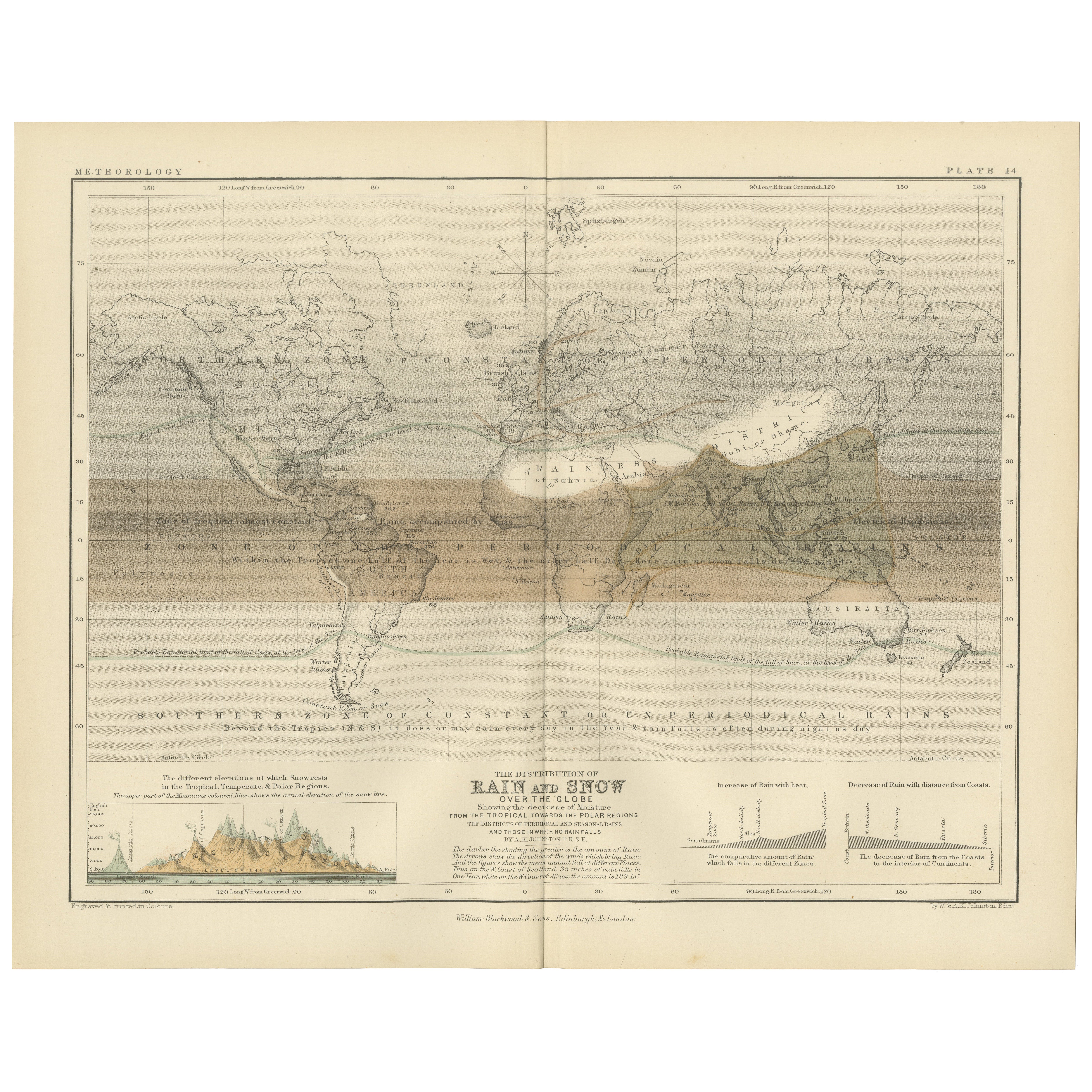
Rain and Snow Map by A.K. Johnston – Global Precipitation Chart 1852
Rain and Snow Map by A.K. Johnston – Global Precipitation Chart 1852
This antique meteorological chart titled "The Distribution of Rain and Snow over the Globe" was created by Alexa...
Catégorie
Antiquités, Milieu du XIXe siècle, Écossais, Estampes
Matériaux
Papier
Carte ancienne montrant les lignes d'Isotherm dans le monde entier par Johnston '1850'
Carte ancienne intitulée "Système de lignes isothermes de Humboldt". Carte ancienne originale montrant les lignes d'isothermes à travers le monde. Cette carte est tirée de "The Physi...
Catégorie
Antiquités, Milieu du XIXe siècle, Cartes
Matériaux
Papier

160 € Prix de vente
20 % de remise
Carte ancienne du monde montrant la distribution des plantes et des minéraux, 1872
Carte ancienne intitulée "Johnson's World showing the distribution of the Characteristic Forest Trees (...)". Carte du monde originale montrant la répartition des plantes et des miné...
Catégorie
Antiquités, Fin du XIXe siècle, Cartes
Matériaux
Papier

160 € Prix de vente
20 % de remise
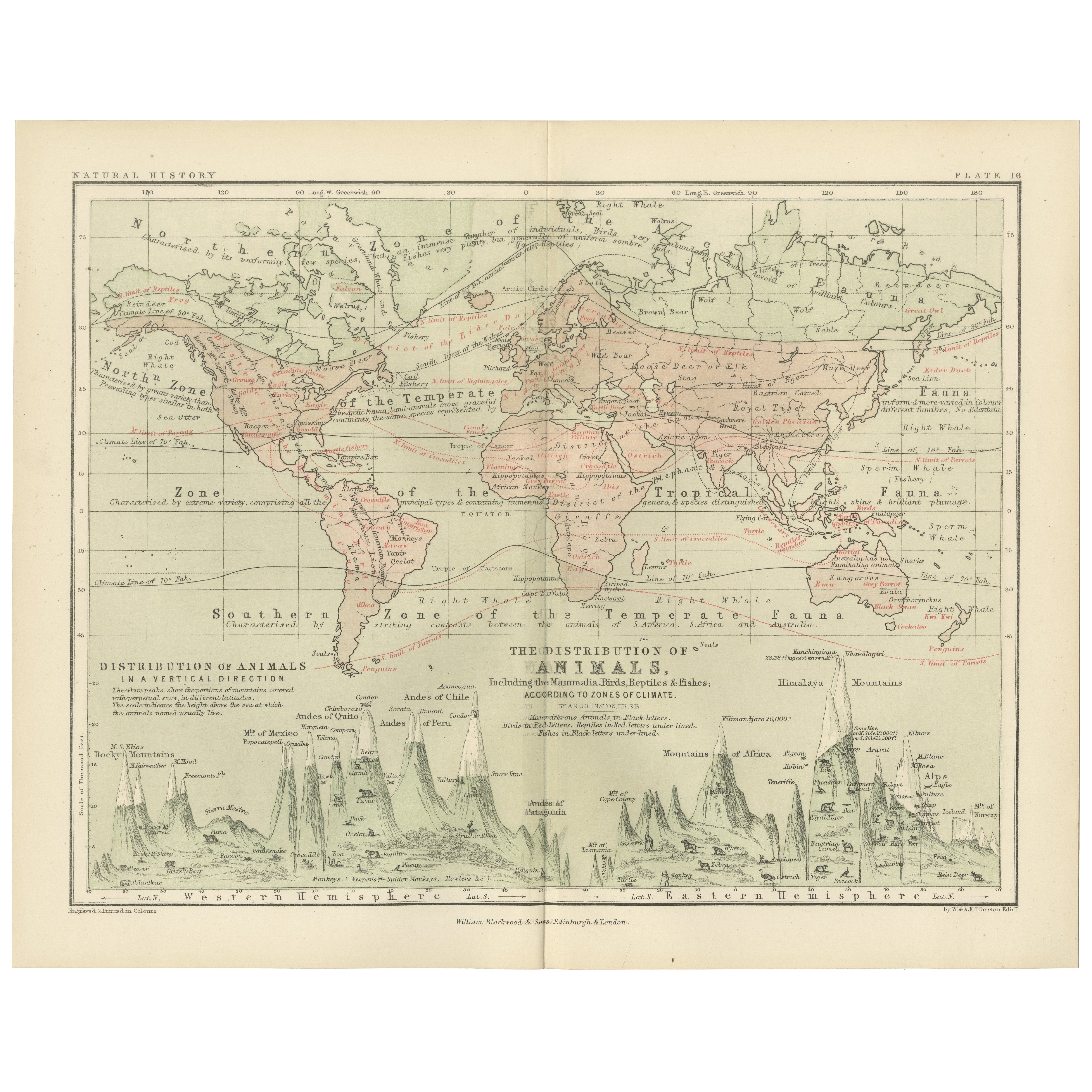
Animal Distribution Map by A.K. Johnston – Fauna by Climate Zones 1852
Animal Distribution Map by A.K. Johnston – Fauna by Climate Zones 1852
This beautifully engraved chart titled "The Distribution of Animals Including the Mammalia, Birds, Reptiles & ...
Catégorie
Antiquités, Milieu du XIXe siècle, Écossais, Estampes
Matériaux
Papier
Carte ancienne montrant les courants océaniques et la température de l'air, '1872'
Deux cartes sur une feuille intitulées 'Johnson's Oceans Currents (...)' et 'Johnson's World showing the Distribution of the Temperature of the Air'. Carte du monde originale montran...
Catégorie
Antiquités, Fin du XIXe siècle, Cartes
Matériaux
Papier

280 € Prix de vente
20 % de remise
Suggestions
Carte originale et ancienne du monde par Thomas Clerk, 1817
Grande carte des hémisphères oriental et occidental
Sur 2 feuilles
Gravure sur cuivre
Dessiné et gravé par Thomas Clerk, Édimbourg.
Publié par Mackenzie et Dent, 1817
...
Catégorie
Antiquités, années 1810, Anglais, Cartes
Matériaux
Papier

Carte ancienne originale de l'hémisphère oriental par Dower, vers 1835
Belle carte de l'hémisphère oriental
Dessiné et gravé par J.Dower
Publié par Orr & Smith. C.1835
Non encadré.
Expédition gratuite
Catégorie
Antiquités, années 1830, Anglais, Cartes
Matériaux
Papier

Hemisphere Of The New Continent - Ancienne carte de J.G. Heck - 1834.
Par Johann Georg Heck
Hémisphère du Nouveau Continent est une œuvre d'art réalisée vers 1760 par Johann Georg Heck
Tirage original en couleur.
Bon état, à l'exception du jaunissement du papier et des d...
Catégorie
années 1830, Moderne, Estampes - Figuratif
Matériaux
Eau-forte

Carte du monde originale et ancienne par Dower, vers 1835
Belle carte du monde
Dessiné et gravé par J.Dower
Publié par Orr & Smith. C.1835
Non encadré.
Expédition gratuite
Catégorie
Antiquités, années 1830, Anglais, Cartes
Matériaux
Papier

Carte ancienne originale de l'hémisphère occidental par Dower, vers 1835
Belle carte de l'hémisphère occidental
Dessiné et gravé par J.Dower
Publié par Orr & Smith. C.1835
Non encadré.
Expédition gratuite
Catégorie
Antiquités, années 1830, Anglais, Cartes
Matériaux
Papier

Carte de l'Empire britannique ancien - Carte ancienne de Karl Spruner - 1760 environ
Par Karl Spruner von Merz
Old British Empire Map est une œuvre d'art réalisée vers 1760 par Karl Spruner.
Épreuve originale colorée à la main.
Bon état sauf un jaunissement du papier le long de la marge, et...
Catégorie
années 1760, Moderne, Estampes - Figuratif
Matériaux
Eau-forte
