Articles similaires à Ethnographic Map of the World by A.K. Johnston – Races of Man Chart 1852


Vous voulez plus d'images ou de vidéos ?
Demander au vendeur plus d'images ou de vidéos
1 sur 10
Ethnographic Map of the World by A.K. Johnston – Races of Man Chart 1852
260 €par article|TVA incluse
Quantité
Expédition
Recherche du devis...La promesse 1stDibs :
Garantie d'authenticité,
Garantie de remboursement,
Annulation sous 24 heures
À propos de cet article
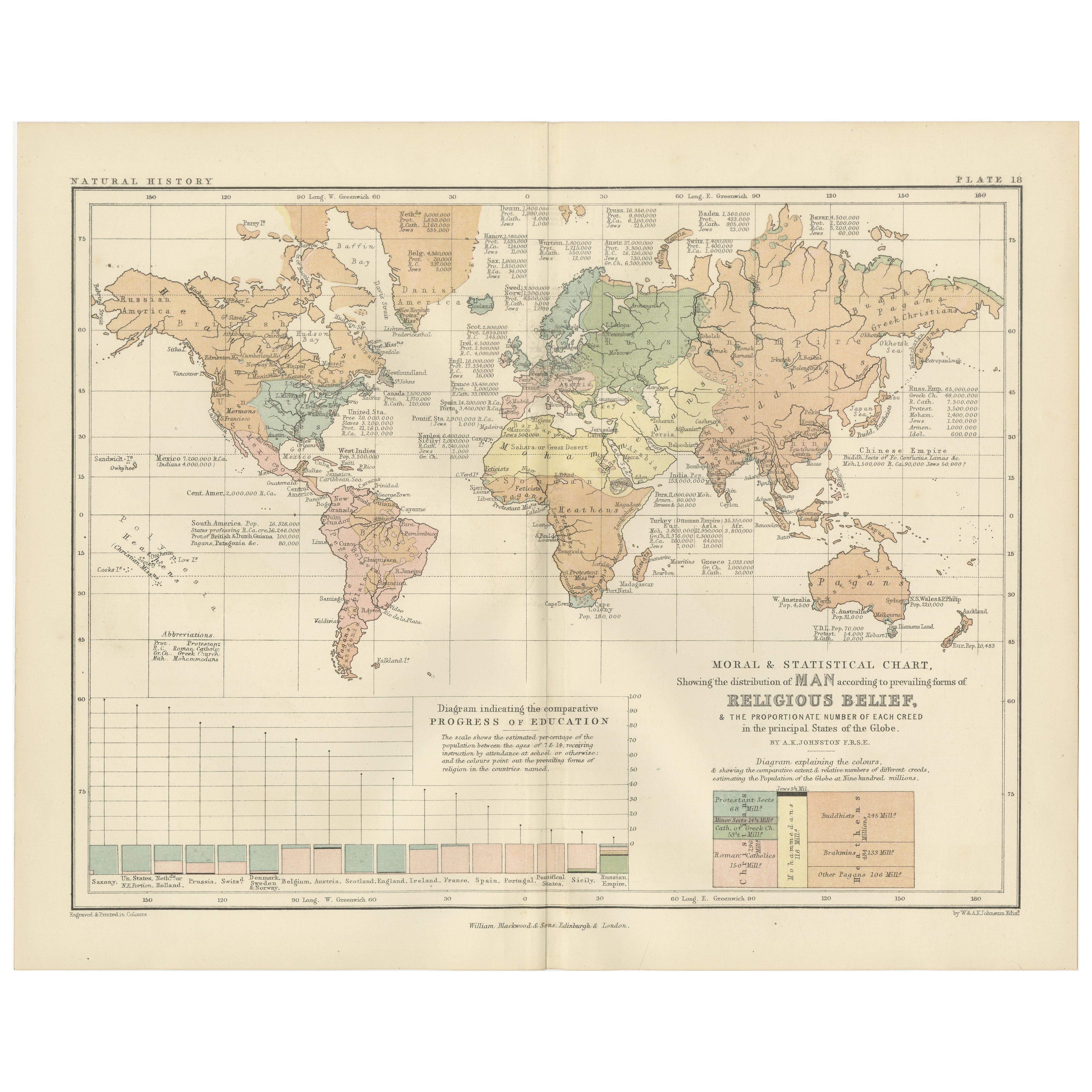
Ethnographic Map of the World by A.K. Johnston – Races of Man Chart 1852
This antique map titled "Ethnographic Map of the World Showing the Present Distribution of the Leading Races of Man" was created by Alexander Keith Johnston and published in 1852 by William Blackwood & Sons in Edinburgh and London. Issued as Plate 17 in Johnston’s *Physical Atlas of Natural Phenomena*, this map reflects 19th-century efforts to visualize human diversity across the globe through early ethnographic theory.
The map categorizes the world's populations into ten generalized racial and cultural groupings, each represented in distinct pastel shades. These include classifications such as Indo-European, Semitic, Negro, Mongolian, Malay, American, and others based on contemporary (now outdated) 19th-century anthropological thought. The regions of distribution are shaded accordingly, spanning continents from the Arctic Circle to the islands of the Pacific.
A large inset map at the bottom right provides a focused view of Europe, showing greater detail in the distribution of groups such as Slavonic, Germanic, Celtic, Basque, and Finnic peoples. Alongside it is a striking profile diagram illustrating the elevation of Earth's landmasses, tying physical geography to patterns of human settlement.
This map, like many from the mid-19th century, combines the empirical ambitions of early anthropology with the visual clarity of scientific cartography. While its categories and terminology are now considered outdated and oversimplified, the chart is an important artifact from the history of ethnography and reflects the European scientific worldview of the time.
Alexander Keith Johnston (1804–1871), one of the most respected geographers of his age, created the *Physical Atlas* as an educational tool to help readers understand the natural world and its human patterns through maps. His work remains a landmark in the development of thematic cartography.
This plate is a compelling object for collectors of antique maps, anthropology history, or Victorian educational materials, and is often studied for its role in the evolution of ethnographic science.
Condition and framing tips:
Very good condition with minimal age toning and a clean printed surface. Centerfold as issued. Frame in black or dark oak wood with a neutral ivory or parchment mat to complement the subdued palette and historic typography. Suitable for a library, academic office, or collection of early scientific prints.
- Dimensions:Hauteur : 27,4 cm (10,79 po)Largeur : 34,5 cm (13,59 po)Profondeur : 0,2 mm (0,01 po)
- Matériaux et techniques:
- Lieu d'origine:
- Période:
- Date de fabrication:1852
- État:Very good condition. Light overall toning near the margins and some offset over Europe. The paper remains strong and well-preserved. Folding line as issued.
- Adresse du vendeur:Langweer, NL
- Numéro de référence:Vendeur : BG-13207-171stDibs : LU3054345393552
À propos du vendeur
5,0
Vendeur reconnu
Ces vendeurs prestigieux sont des leaders du secteur. Ils représentent le summum en matière de qualité et de design.
Vendeur Platine
Vendeurs premium dont la note est supérieure à 4,7 et le délai de réponse de 24 heures maximum
Établi en 2009
Vendeur 1stDibs depuis 2017
2 492 ventes sur 1stDibs
Temps de réponse habituel : <1 heure
- ExpéditionRecherche du devis...Expédition depuis : Langweer, Pays-Bas
- Politique des retours
Certaines parties de cette page ont été traduites automatiquement. 1stDibs ne garantit pas l'exactitude des traductions. L'anglais est la langue par défaut de ce site web.
Garantie d'authenticité
Bien qu'il soit peu probable que la situation se présente, dans le cas où vous rencontreriez un problème d'authenticité d'un article, contactez-nous dans un délai d'un an pour obtenir un remboursement intégral. DétailsGarantie de remboursement
Si votre article n'est pas conforme à la description, est endommagé pendant le transport ou ne vous est pas livré, contactez-nous sous 7 jours pour obtenir un remboursement intégral. DétailsAnnulation sous 24 heures
Vous disposez d'un délai de 24 heures pour annuler votre achat sans motif.Des vendeurs professionnels agréés
Nos vendeurs de renommée mondiale doivent respecter des normes strictes en matière de service et de qualité, afin de préserver l'intégrité de nos fiches produit.Garantie d'alignement des prix
Si vous constatez qu'un autre vendeur a mis en vente le même article à un prix inférieur sur un autre site, nous nous alignerons sur ce prix.Livraison en toute confiance à l'international
Notre réseau de transporteurs de premier ordre propose des options d'expédition spécialisées dans le monde entier, y compris des livraisons personnalisées.Plus d'articles de ce vendeur
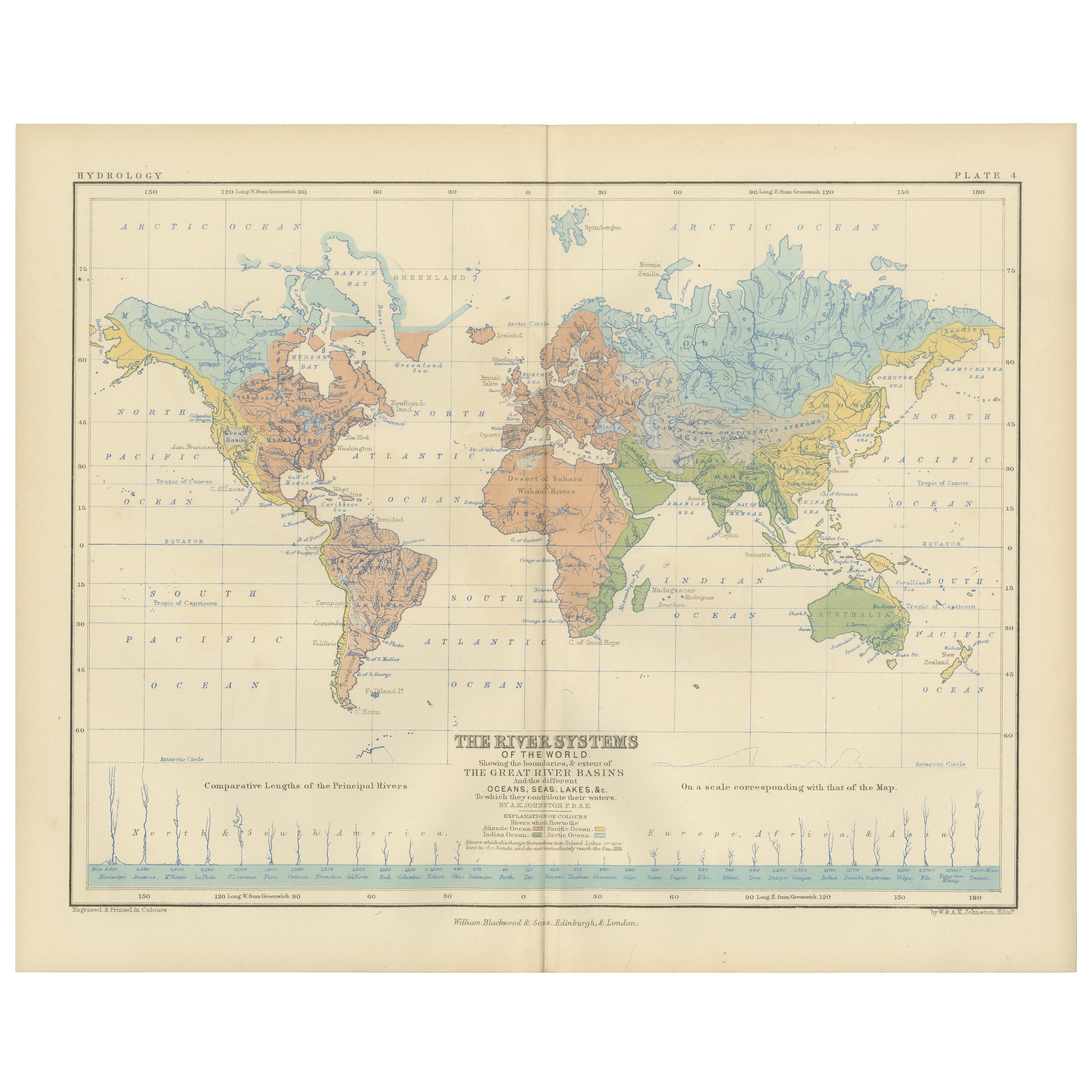
Tout afficherRiver Systems Map of the World by A.K. Johnston – Educational Print 1852
River Systems Map of the World by A.K. Johnston – Educational Print 1852
This striking 1852 map titled "The River Systems of the World" was created by the noted Scottish geographer ...
Catégorie
Antiquités, Milieu du XIXe siècle, Écossais, Estampes
Matériaux
Papier

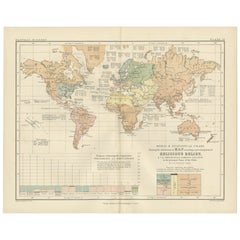
Carte ancienne montrant les religions du monde entier par Johnston '1854'
Carte ancienne intitulée "Moral & Statistical Chart showing the Geographical Distribution of Man According to Religious Belief". Rare carte thématique de grande taille sur la réparti...
Catégorie
Antiquités, Milieu du XIXe siècle, Cartes
Matériaux
Papier

780 € Prix de vente
35 % de remise
Religious Belief Map by A.K. Johnston – Moral and Statistical Chart 1852
Religious Belief Map by A.K. Johnston – Moral and Statistical Chart 1852
This antique chart titled "Moral & Statistical Chart Showing the Distribution of Man According to Prevailing...
Catégorie
Antiquités, Milieu du XIXe siècle, Écossais, Estampes
Matériaux
Papier
Carte ancienne du monde montrant la distribution des plantes et des minéraux, 1872
Carte ancienne intitulée "Johnson's World showing the distribution of the Characteristic Forest Trees (...)". Carte du monde originale montrant la répartition des plantes et des miné...
Catégorie
Antiquités, Fin du XIXe siècle, Cartes
Matériaux
Papier

160 € Prix de vente
20 % de remise
Carte ancienne montrant la division et la distribution des mammouths par Johnston '1850'
Carte ancienne intitulée "Geographical division and distribution of mammiferous animals of the orders rodentia and ruminantia over the globe". Carte ancienne originale montrant la di...
Catégorie
Antiquités, Milieu du XIXe siècle, Cartes
Matériaux
Papier

160 € Prix de vente
20 % de remise
Carte ancienne montrant la distribution des plantes par Johnston '1850'
Carte ancienne intitulée "Plantes géographiques utilisées pour l'alimentation de l'homme". Carte ancienne originale montrant la répartition des plantes. Cette carte provient de "The ...
Catégorie
Antiquités, Milieu du XIXe siècle, Cartes
Matériaux
Papier
160 € Prix de vente
20 % de remise
Suggestions
Carte du monde originale et ancienne par Dower, vers 1835
Belle carte du monde
Dessiné et gravé par J.Dower
Publié par Orr & Smith. C.1835
Non encadré.
Expédition gratuite
Catégorie
Antiquités, années 1830, Anglais, Cartes
Matériaux
Papier

Planisphere originale illustrée - Carte du monde - Géographie, 1864
Plongez dans l'épopée du passé avec le Planisphère historique illustré de 1864 par Charpentier ! 🗺️ Ce trésor cartographique vous transporte dans les méandres de l'histoire, avec de...
Catégorie
années 1860, Estampes et éditions
Matériaux
Lin, Lithographie, Papier

Carte de l'Empire britannique ancien - Carte ancienne de Karl Spruner - 1760 environ
Par Karl Spruner von Merz
Old British Empire Map est une œuvre d'art réalisée vers 1760 par Karl Spruner.
Épreuve originale colorée à la main.
Bon état sauf un jaunissement du papier le long de la marge, et...
Catégorie
années 1760, Moderne, Estampes - Figuratif
Matériaux
Eau-forte

Carte du monde - Gravure originale - 1820
Carte du monde est une gravure originale réalisée par un artiste inconnu du 19ème siècle en 1820.
Très bon état sur deux feuilles de papier blanc j...
Catégorie
années 1820, Moderne, Estampes - Figuratif
Matériaux
Eau-forte

Carte originale et ancienne du monde par Thomas Clerk, 1817
Grande carte des hémisphères oriental et occidental
Sur 2 feuilles
Gravure sur cuivre
Dessiné et gravé par Thomas Clerk, Édimbourg.
Publié par Mackenzie et Dent, 1817
...
Catégorie
Antiquités, années 1810, Anglais, Cartes
Matériaux
Papier

Carte ancienne originale de l'hémisphère oriental par Dower, vers 1835
Belle carte de l'hémisphère oriental
Dessiné et gravé par J.Dower
Publié par Orr & Smith. C.1835
Non encadré.
Expédition gratuite
Catégorie
Antiquités, années 1830, Anglais, Cartes
Matériaux
Papier
