Articles similaires à Carte de France 1757 - Provinces du Sud par Isaak Tirion en gravure hollandaise


Chargement de la vidéo
Vous voulez plus d'images ou de vidéos ?
Demander au vendeur plus d'images ou de vidéos
1 sur 12
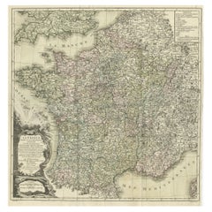
Carte de France 1757 - Provinces du Sud par Isaak Tirion en gravure hollandaise
390 €TVA incluse
À propos de cet article
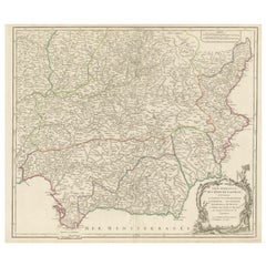
France Map 1757 – Southern Provinces by Isaak Tirion in Dutch Engraving
This original copperplate engraving published in 1757 by Isaak Tirion in Amsterdam presents a highly detailed and accurate map of southern France, titled *Nieuwe en Naaukeurige Kaart van het Zuidelyk Gedeelte van Frankryk*. Created during the Age of Enlightenment, this map reflects the Dutch tradition of precise geographical scholarship and decorative cartography.
Covering the entirety of southern France from the Atlantic coast at Bordeaux and Bayonne to the Mediterranean coastline including Marseille, Toulon, and the Gulf of Lyon, this map is rich in topographic and political detail. It shows the provincial divisions, major towns and cities, rivers, and mountainous regions with remarkable clarity. The coverage stretches from the Pyrenees and the Spanish border in the southwest through the Rhône Valley and into Dauphiné and Provence in the southeast.
The title cartouche in the lower left is printed in Dutch and includes a dedication to the geographical authorities of the era, while referencing the work of the French Academy. This indicates that the map was informed by the most reliable sources of its time, ensuring both scholarly precision and contemporary relevance.
Isaak Tirion (1705–1765) was a noted Dutch publisher and cartographer whose works were widely respected for their clarity and accuracy. His maps appeared in his landmark atlases such as the *Hedendaagsche Historie* and the *Nieuwe en Beknopte Hand-Atlas*. This map is a fine example of his style, emphasizing readability and elegant engraving.
Condition:
This antique map is in good condition for its age. There is are vertical folds as issued, with some light foxing, fold wear, and small edge tears outside the printed image. The paper retains good strength and the impression is crisp and clean with sharp detail.
Framing Tips:
For display, consider a simple but classic black or dark walnut frame with a warm off-white or cream-colored mat. Alternatively, a gold-accented frame can enhance the historical feel. This map makes a refined addition to any study, library, or travel-themed interior, especially for collectors of French or Dutch cartography.
- Dimensions:Hauteur : 28 cm (11,03 po)Largeur : 47,5 cm (18,71 po)Profondeur : 0,2 mm (0,01 po)
- Matériaux et techniques:Papier,Gravé
- Lieu d'origine:
- Période:
- Date de fabrication:1757
- État:Réparé: two tears have been restored with tape on the back side. Good condition for its age. There is are vertical folds as issued, with some light foxing, fold wear, and small edge tears outside the printed image. The impression is crisp and clean. Two repairs on the backside with tape.
- Adresse du vendeur:Langweer, NL
- Numéro de référence:Vendeur : BG-14031-11stDibs : LU3054345437872
À propos du vendeur
5,0
Vendeur reconnu
Ces vendeurs prestigieux sont des leaders du secteur. Ils représentent le summum en matière de qualité et de design.
Vendeur Platine
Vendeurs premium dont la note est supérieure à 4,7 et le délai de réponse de 24 heures maximum
Établi en 2009
Vendeur 1stDibs depuis 2017
2 567 ventes sur 1stDibs
Temps de réponse habituel : <1 heure
- ExpéditionRecherche du devis...Expédition depuis : Langweer, Pays-Bas
- Politique des retours
Certaines parties de cette page ont été traduites automatiquement. 1stDibs ne garantit pas l'exactitude des traductions. L'anglais est la langue par défaut de ce site web.
Garantie d'authenticité
Bien qu'il soit peu probable que la situation se présente, dans le cas où vous rencontreriez un problème d'authenticité d'un article, contactez-nous dans un délai d'un an pour obtenir un remboursement intégral. DétailsGarantie de remboursement
Si votre article n'est pas conforme à la description, est endommagé pendant le transport ou ne vous est pas livré, contactez-nous sous 7 jours pour obtenir un remboursement intégral. DétailsAnnulation sous 24 heures
Vous disposez d'un délai de 24 heures pour annuler votre achat sans motif.Des vendeurs professionnels agréés
Nos vendeurs de renommée mondiale doivent respecter des normes strictes en matière de service et de qualité, afin de préserver l'intégrité de nos fiches produit.Garantie d'alignement des prix
Si vous constatez qu'un autre vendeur a mis en vente le même article à un prix inférieur sur un autre site, nous nous alignerons sur ce prix.Livraison en toute confiance à l'international
Notre réseau de transporteurs de premier ordre propose des options d'expédition spécialisées dans le monde entier, y compris des livraisons personnalisées.Plus d'articles de ce vendeur
Tout afficherCarte ancienne de France avec les canaux anglais, 1754
Carte ancienne de la France intitulée "Carte exacte de la France dressée d'après les meilleures autorités". Petite carte détaillée de la France. Avec cartouche de titre décoratif.
...
Catégorie
Antiquités, XVIIIe siècle, Cartes
Matériaux
Papier

200 € Prix de vente
20 % de remise
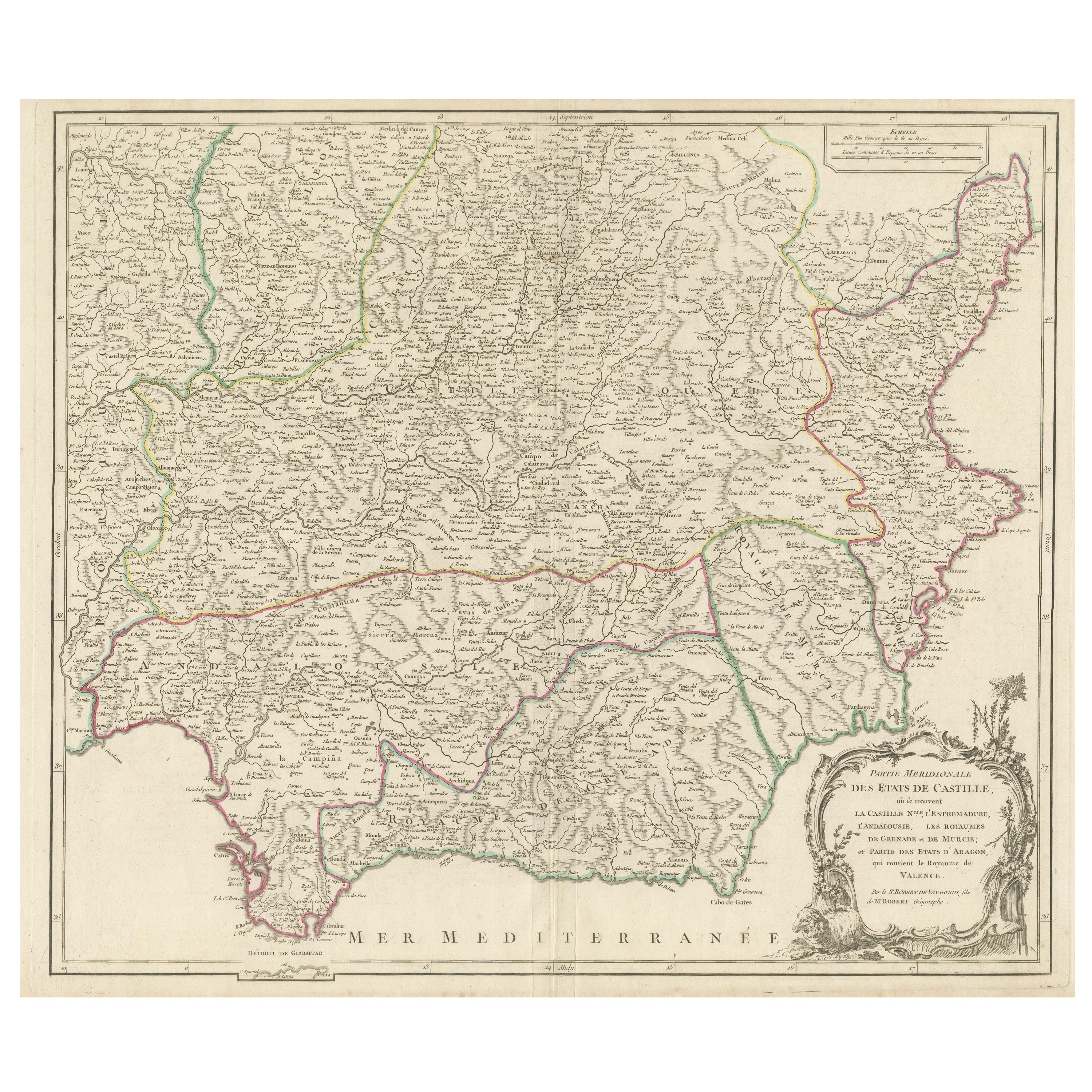
Gravure détaillée mettant en valeur les régions clés du sud de l'Espagne et de la Castille, 1752
Carte ancienne intitulée "Partie Meridionale Des Etats de Castille (...)". Carte décorative et très détaillée de la partie sud de la Castille, Espagne, comprenant un cartouche décora...
Catégorie
Antiquités, Milieu du XVIIIe siècle, Cartes
Matériaux
Papier
528 € Prix de vente
20 % de remise
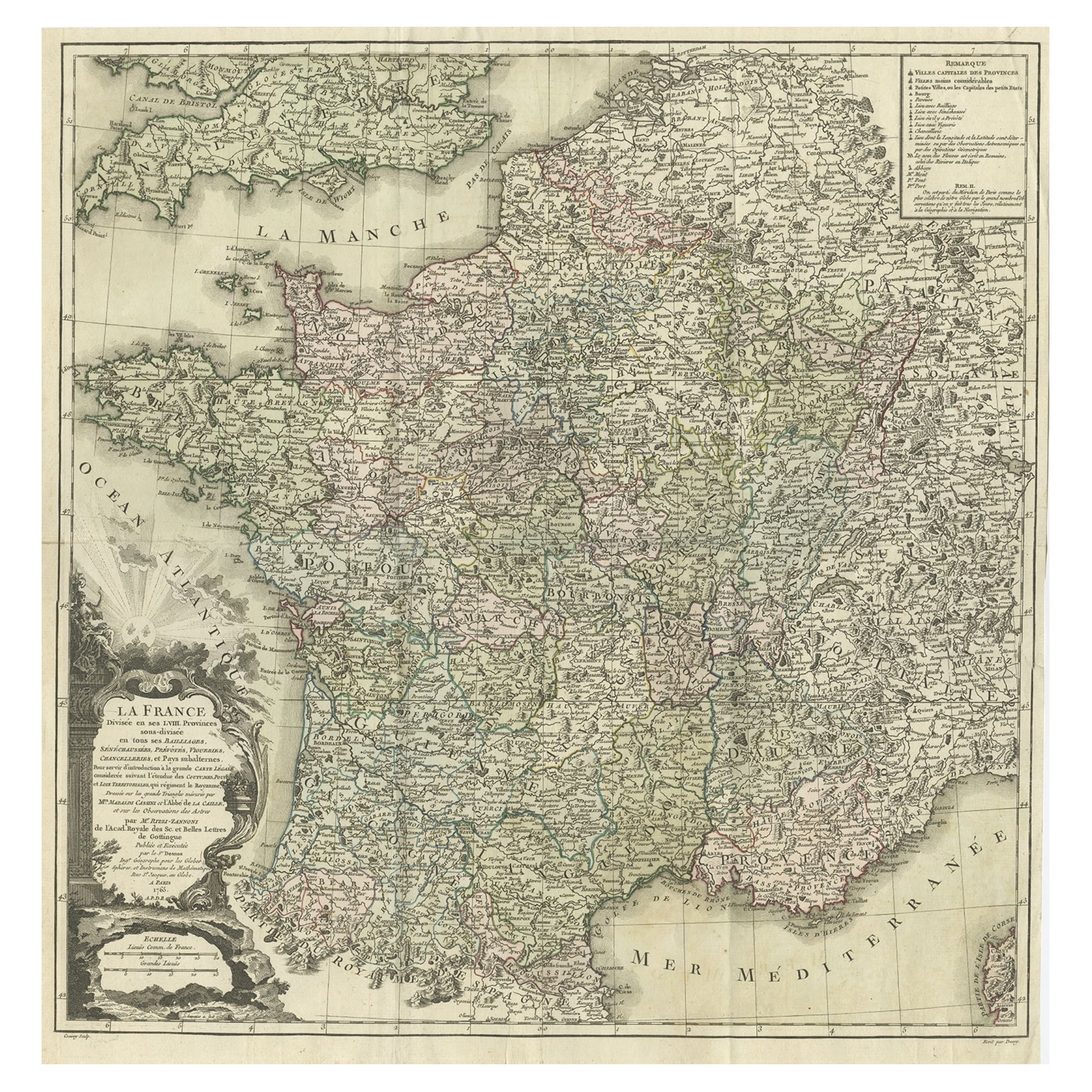
Carte ancienne de France par Zannoni, 1765
Carte ancienne intitulée 'La France divisée en ses LVIII Provinces (...)'. Belle carte ancienne de la France. Cette carte est tirée de l'Atlas Historique de la France Ancienne et Mod...
Catégorie
Antiquités, XVIIIe siècle, Cartes
Matériaux
Papier
416 € Prix de vente
20 % de remise
Carte miniature antique détaillée de la France par Mallet, vers1683
Carte ancienne intitulée "France en général". BG-11796-55. Provient de la "Description de l'Univers" de Mallet.
Artistes et graveurs : Alain Manneson Mallet (1630-1706) a passé la...
Catégorie
Antiquités, 17ème siècle, Cartes
Matériaux
Papier
128 € Prix de vente
20 % de remise
Carte ancienne de la France ancienne par Zannoni, 1765
Carte ancienne de France intitulée "Galliae Veteris (..)". Belle carte ancienne de la France. Cette carte provient de l'"Atlas historique de la France ancienne et moderne" de M. Rizz...
Catégorie
Antiquités, XVIIIe siècle, Cartes
Matériaux
Papier

256 € Prix de vente
20 % de remise
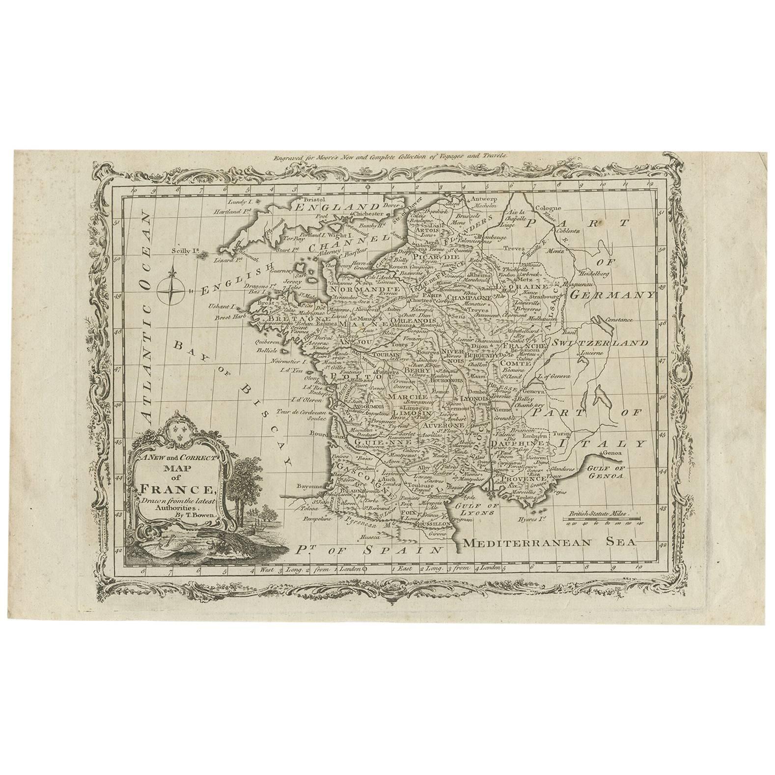
Carte ancienne de France par T. Bowen, 1785
Carte ancienne décorative de la France intitulée 'A new and accurate map of France, Drawn from the latest Authorities by T. Bowen'. Gravé pour la nouvelle et complète collection de v...
Catégorie
Antiquités, Fin du XVIIIe siècle, Cartes
Matériaux
Papier
128 € Prix de vente
20 % de remise
Suggestions
Carte ancienne de Li Governi di Borgogna - 1777
Li Governi di Borgogna est une gravure originale en noir et blanc sur papier, imprimée par Antonio Zatta à Venise, en 1777.
Titre original : Li Governi di Borgogna della Franca Cont...
Catégorie
années 1770, Moderne, Estampes - Paysage
Matériaux
Eau-forte

Carte de la Terre Sainte gravée van Loon publiée N de Fer 1703 français
La Terre Sainte, La Lande, Tiree Des Memoires De M.De.La Rue. Par N. de Fer. Géographe de Sa Majestic Catoliq et de Monseigneur le Dauphin. Avec Privil du Roi 1703
Carte détaillée de la Lande d'après L'Atlas Curieux ou le Monde de Nicolas de Or. L'Est est orienté vers le haut.
FABRICANT Nicolas de Fer...
Catégorie
Antiquités, Début des années 1700, Français, Louis XIV, Cartes
Matériaux
Papier

Carte d'Espagne de 1751 Castilla Robert De Vaugondy 1ère édition, Ric.a001
Grande Espagne Castilla Robert De Vaugondy
1751 1ère édition
-Coloré- Ric.a001
Issu d'une famille de cartographes, descendant du célèbre Nicolas Sanson et géographe ordinaire d...
Catégorie
Antiquités, XVIIIe siècle, Inconnu, Cartes
Matériaux
Papier

Carte Bonne de Poitou, Touraine et Anjou, France, Ric.a015, 1771
1771 Bonne carte du Poitou,
Touraine et Anjou, France
Ric.a015
1771 Carte de Potiou, Touraine et Anjou intitulée "Carte des Gouvernements D'Anjou et du Saumurois, de la Tour...
Catégorie
Antiquités, 17ème siècle, Inconnu, Cartes
Matériaux
Papier

1714 Henri Chatelain ""Nouvelle Carte Des Etatas Du Grand.Duc De Mos Moscovie Eur"".
Une carte d'Henri Chatelain de 1714, intitulée
"Nouvelle Carte Des Etatas Du Grand Duc De Moscovie En Europe,"
Ricb001
Henri Abraham Chatelain (1684-1743) était un pasteur hugu...
Catégorie
Antiquités, Début du XVIIIe siècle, Néerlandais, Cartes
Matériaux
Papier

Carte de la France - Gravure - 1820
Carte de France est une Gravure originale réalisée par un artiste inconnu du 19ème siècle en 1820.
Très bon état sur deux feuilles de papier blanc jointes au centre.
La carte est u...
Catégorie
années 1820, Moderne, Estampes - Figuratif
Matériaux
Eau-forte
