Articles similaires à Map of Ariège France with Foix and Pyrenees Landscape by Vuillemin, 19th c


Vous voulez plus d'images ou de vidéos ?
Demander au vendeur plus d'images ou de vidéos
1 sur 11
Map of Ariège France with Foix and Pyrenees Landscape by Vuillemin, 19th c
120 €TVA incluse
À propos de cet article
Map of Ariège France with Foix and Pyrenees Landscape by Vuillemin, 19th c
Description:
This beautifully detailed 19th-century map of the Ariège department in southwestern France was drawn by the French cartographer Alexandre Vuillemin and published by Migeon in Paris as part of the illustrated Nouvel Atlas Illustré. Rich in visual and historical content, the map offers a fascinating portrait of this mountainous border region adjacent to Spain and Andorra.
The map shows the full expanse of Ariège with clear labeling of towns, rivers, roads, and departmental borders, the latter highlighted in hand-applied yellow watercolor. The department is nestled against the Pyrenees mountain range, with Foix, Saint-Girons, and Pamiers as its major towns. The topographical relief hints at the region's rugged alpine character.
To the lower left is a picturesque vignette of Foix, the departmental capital, with its famous medieval castle perched dramatically on a rocky hill above the town. On the lower right is a view of the southern borderlands facing the Spanish frontier. At the upper right appears a portrait of General Bertrand Clausel, a native of Ariège who served in the Napoleonic Wars and later became governor of Algeria. Beneath him is the coat of arms of the department, with its vertical stripes and laurel branch motif.
Ariège is known for its striking mountain scenery, medieval fortresses, Cathar heritage, and natural thermal springs. Although not widely recognized as a major wine-producing area, it does have a tradition of small-scale viticulture, especially in the foothills, with rustic wines from local grapes. The area is more renowned for sheep cheese (such as tomme and Bethmale), honey, and mountain herbal products. Today, it is popular among hikers, cyclists, and nature lovers for its unspoiled valleys and ancient hilltop villages.
Alexandre Vuillemin was a leading 19th-century French cartographer noted for integrating history, culture, and art into his maps. His works were both educational and decorative, making them highly collectible. The publisher, Migeon, specialized in atlases that appealed to a broad public through refined design and engraving quality.
Condition summary:
Very good condition with light age toning and a few minor foxing marks in the margins. Engraved lines are sharp, and the hand coloring is clean and well preserved.
Framing tips:
This map would look excellent in a walnut or natural wood frame to complement its rustic and mountainous theme. A soft cream or ivory mat will enhance the engraved detail and yellow border. Museum glass is recommended for optimal preservation.
- Dimensions:Hauteur : 26,1 cm (10,28 po)Largeur : 32,5 cm (12,8 po)Profondeur : 0,2 mm (0,01 po)
- Matériaux et techniques:Papier,Gravé
- Lieu d'origine:
- Période:
- Date de fabrication:circa 1850
- État:Very good condition with light age toning and a few minor foxing marks in the margins. Engraved lines are sharp, and the hand coloring is clean and well preserved.
- Adresse du vendeur:Langweer, NL
- Numéro de référence:Vendeur : BG-13331-81stDibs : LU3054345359562
À propos du vendeur
5,0
Vendeur reconnu
Ces vendeurs prestigieux sont des leaders du secteur. Ils représentent le summum en matière de qualité et de design.
Vendeur Platine
Vendeurs premium dont la note est supérieure à 4,7 et le délai de réponse de 24 heures maximum
Établi en 2009
Vendeur 1stDibs depuis 2017
2 567 ventes sur 1stDibs
Temps de réponse habituel : <1 heure
- ExpéditionRecherche du devis...Expédition depuis : Langweer, Pays-Bas
- Politique des retours
Certaines parties de cette page ont été traduites automatiquement. 1stDibs ne garantit pas l'exactitude des traductions. L'anglais est la langue par défaut de ce site web.
Garantie d'authenticité
Bien qu'il soit peu probable que la situation se présente, dans le cas où vous rencontreriez un problème d'authenticité d'un article, contactez-nous dans un délai d'un an pour obtenir un remboursement intégral. DétailsGarantie de remboursement
Si votre article n'est pas conforme à la description, est endommagé pendant le transport ou ne vous est pas livré, contactez-nous sous 7 jours pour obtenir un remboursement intégral. DétailsAnnulation sous 24 heures
Vous disposez d'un délai de 24 heures pour annuler votre achat sans motif.Des vendeurs professionnels agréés
Nos vendeurs de renommée mondiale doivent respecter des normes strictes en matière de service et de qualité, afin de préserver l'intégrité de nos fiches produit.Garantie d'alignement des prix
Si vous constatez qu'un autre vendeur a mis en vente le même article à un prix inférieur sur un autre site, nous nous alignerons sur ce prix.Livraison en toute confiance à l'international
Notre réseau de transporteurs de premier ordre propose des options d'expédition spécialisées dans le monde entier, y compris des livraisons personnalisées.Plus d'articles de ce vendeur
Tout afficherMap of Ardèche France with Annonay and Vineyards by Vuillemin, 19th c
Map of Ardèche France with Annonay and Vineyards by Vuillemin, 19th c
This beautifully engraved 19th-century map of Ardèche, a department in southeastern France, comes from Alexandr...
Catégorie
Antiquités, Milieu du XIXe siècle, Français, Cartes
Matériaux
Papier

Map of Côtes-du-Nord France with Saint-Brieuc and Brittany Coastline, c.1850
Map of Côtes-du-Nord France with Saint-Brieuc and Brittany Coastline, 19th c
Description:
This elegant 19th-century map of Côtes-du-Nord, the historic name for what is now known as ...
Catégorie
Antiquités, Milieu du XIXe siècle, Français, Cartes
Matériaux
Papier

Map of Allier France with Saint-Pourçain Wine Region by Vuillemin, 19th c
Map of Allier France with Saint-Pourçain Wine Region by Vuillemin, 19th c
This decorative 19th-century map of Allier, a central department of France, comes from the celebrated Nouve...
Catégorie
Antiquités, Milieu du XIXe siècle, Français, Cartes
Matériaux
Papier

Map of Aude France with Carcassonne and Languedoc Vineyards, 19th Century
Map of Aude France with Carcassonne and Languedoc Vineyards, 19th Century
Description:
This elegant 19th-century map of Aude, a department in southern France along the Mediterranean...
Catégorie
Antiquités, Milieu du XIXe siècle, Français, Cartes
Matériaux
Papier

Map of Aisne France with Soissons and Champagne Vineyards by Vuillemin, 19th c
Map of Aisne France with Soissons and Champagne Vineyards by Vuillemin, 19th c
Description:
This richly detailed 19th-century engraved and hand-colored map of the department of Aisn...
Catégorie
Antiquités, Milieu du XIXe siècle, Français, Cartes
Matériaux
Papier

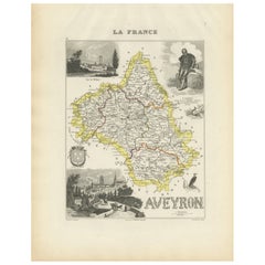
Map of Aveyron France with Rodez, Millau and Wine Routes, 19th Century
Map of Aveyron France with Rodez, Millau and Wine Routes, 19th Century
Description:
This detailed and decorative 19th-century map of Aveyron, a department in southern France, was dr...
Catégorie
Antiquités, Milieu du XIXe siècle, Français, Cartes
Matériaux
Papier
Suggestions
Lozere, France. Carte ancienne d'un département français, 1856
Par Victor Levasseur
département de la Lozère, gravure sur acier avec contour original coloré à la main, 1856, de l'Atlas national illustré de Levasseur.
Cette partie montagneuse isolée du Languedoc es...
Catégorie
XIXe siècle, Naturalisme, Estampes - Paysage
Matériaux
Gravure

L'Isere, France. Carte ancienne du département français de l'antiquité, 1856
Par Victor Levasseur
département de l'Isère, gravure sur acier avec contour original coloré à la main, 1856, de l'Atlas national illustré de Levasseur.
Cette région est connue pour sa production de Ble...
Catégorie
XIXe siècle, Naturalisme, Estampes - Paysage
Matériaux
Gravure

Pyrenees Orientales, France. Carte ancienne d'un département français, 1856
Par Victor Levasseur
dept. des Pyrénées Orientales", gravure sur acier avec contour original coloré à la main, 1856, de l'Atlas National Illustre de Levasseur.
Cette région est une région viticole répu...
Catégorie
XIXe siècle, Naturalisme, Estampes - Paysage
Matériaux
Gravure

Aude, France. Carte ancienne d'un département français, 1856
Par Victor Levasseur
département de l'Aude, gravure sur acier avec contour original coloré à la main, 1856, de l'Atlas national illustré de Levasseur.
Cette région de France est célèbre pour sa grande ...
Catégorie
XIXe siècle, Naturalisme, Estampes - Paysage
Matériaux
Gravure

Aube, France. Carte ancienne d'un département français, 1856
Par Victor Levasseur
département de l'Aube, gravure sur acier avec contour original coloré à la main, 1856, de l'Atlas national illustré de Levasseur.
Cette région de France est connue pour sa producti...
Catégorie
XIXe siècle, Naturalisme, Estampes - Paysage
Matériaux
Gravure

Les Hautes Alpes, France. Carte ancienne d'un département français, 1856
Par Victor Levasseur
département des Hautes Alpes", gravure sur acier avec contour original coloré à la main, 1856, tirée de l'Atlas national illustré de Levasseur.
Cette...
Catégorie
XIXe siècle, Naturalisme, Estampes - Paysage
Matériaux
Gravure
