Articles similaires à Map of Basses-Alpes France with Digne and Lavender Region by Vuillemin, c.1850


Vous voulez plus d'images ou de vidéos ?
Demander au vendeur plus d'images ou de vidéos
1 sur 10
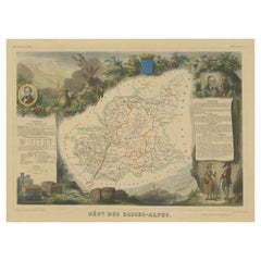
Map of Basses-Alpes France with Digne and Lavender Region by Vuillemin, c.1850
120 €TVA incluse
À propos de cet article
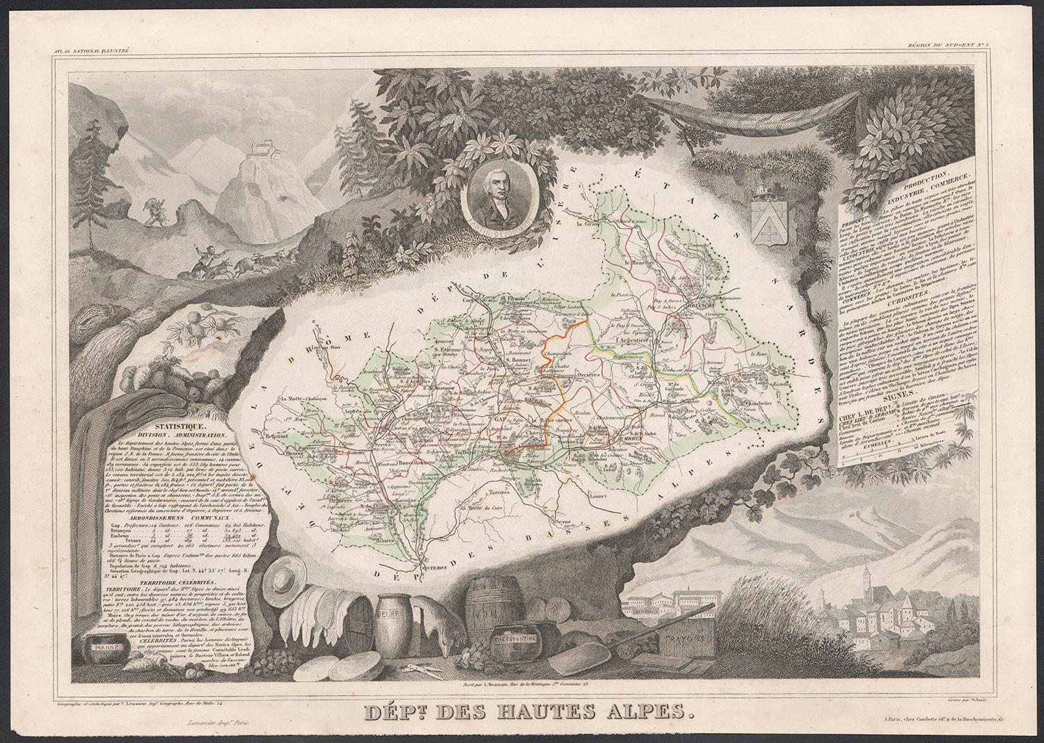
Map of Basses-Alpes France with Digne and Lavender Region by Vuillemin, 19th c
This finely engraved 19th-century map of the Basses-Alpes department of France (known today as Alpes-de-Haute-Provence) is from the renowned Nouvel Atlas Illustré by Alexandre Vuillemin, published by Migeon in Paris. It features delicate hand coloring, regional detail, and elegant vignettes that highlight the cultural and natural identity of the area.
The map outlines the department of Basses-Alpes with clear detail, showcasing towns, rivers, and roads, bordered in soft pastel colors. The mountains, passes, and valleys are rendered with precision, reflecting the department's alpine geography. In the upper left corner, a vignette depicts the town of Digne (now Digne-les-Bains), the administrative center of the department, with the Alps rising in the distance. The bottom left corner features a mountain goat resting on the rocks—an allusion to the region’s wildlife and rugged landscape. To the right, a portrait of Jean-Baptiste Gassendi, philosopher, astronomer, and native of the region, brings historical depth to the composition. Birds flying along the right edge further emphasize the natural richness of the region.
Basses-Alpes is particularly renowned for its stunning lavender fields, which blanket the landscape in purple during summer months. This region, especially the areas around Digne, Forcalquier, and Valensole, is one of the key sources of French lavender, used in perfumes, soaps, and essential oils. In addition to lavender, the region also produces honey, olives, and wines from the Vin de Pays des Alpes-de-Haute-Provence designation.
Alexandre Vuillemin, the cartographer, was a noted 19th-century French mapmaker whose decorative atlases combined geography with culture and art. His publisher, Migeon, specialized in beautifully illustrated educational works. Together, they produced maps that were both informative and visually compelling, popular among scholars and collectors alike.
Condition summary:
Very good condition with slight toning to the margins and a few faint foxing spots, mostly in outer areas. The engraved details are sharp and the original hand-coloring remains clean and attractive.
Framing tips:
This map pairs beautifully with a medium or dark wood frame, or an antique gold moulding to highlight the historic charm. A soft cream or light lavender-toned mat can complement the regional theme. UV-protective glass is recommended to ensure long-term preservation.
- Dimensions:Hauteur : 26,1 cm (10,28 po)Largeur : 32,5 cm (12,8 po)Profondeur : 0,2 mm (0,01 po)
- Matériaux et techniques:Papier,Gravé
- Lieu d'origine:
- Période:
- Date de fabrication:circa 1850
- État:Very good condition with slight toning to the margins and a few faint foxing spots, mostly in outer areas. The engraved details are sharp and the original hand-coloring remains clean and attractive.
- Adresse du vendeur:Langweer, NL
- Numéro de référence:Vendeur : BG-13331-41stDibs : LU3054345359142
À propos du vendeur
5,0
Vendeur reconnu
Ces vendeurs prestigieux sont des leaders du secteur. Ils représentent le summum en matière de qualité et de design.
Vendeur Platine
Vendeurs premium dont la note est supérieure à 4,7 et le délai de réponse de 24 heures maximum
Établi en 2009
Vendeur 1stDibs depuis 2017
2 569 ventes sur 1stDibs
Temps de réponse habituel : <1 heure
- ExpéditionRecherche du devis...Expédition depuis : Langweer, Pays-Bas
- Politique des retours
Certaines parties de cette page ont été traduites automatiquement. 1stDibs ne garantit pas l'exactitude des traductions. L'anglais est la langue par défaut de ce site web.
Garantie d'authenticité
Bien qu'il soit peu probable que la situation se présente, dans le cas où vous rencontreriez un problème d'authenticité d'un article, contactez-nous dans un délai d'un an pour obtenir un remboursement intégral. DétailsGarantie de remboursement
Si votre article n'est pas conforme à la description, est endommagé pendant le transport ou ne vous est pas livré, contactez-nous sous 7 jours pour obtenir un remboursement intégral. DétailsAnnulation sous 24 heures
Vous disposez d'un délai de 24 heures pour annuler votre achat sans motif.Des vendeurs professionnels agréés
Nos vendeurs de renommée mondiale doivent respecter des normes strictes en matière de service et de qualité, afin de préserver l'intégrité de nos fiches produit.Garantie d'alignement des prix
Si vous constatez qu'un autre vendeur a mis en vente le même article à un prix inférieur sur un autre site, nous nous alignerons sur ce prix.Livraison en toute confiance à l'international
Notre réseau de transporteurs de premier ordre propose des options d'expédition spécialisées dans le monde entier, y compris des livraisons personnalisées.Plus d'articles de ce vendeur
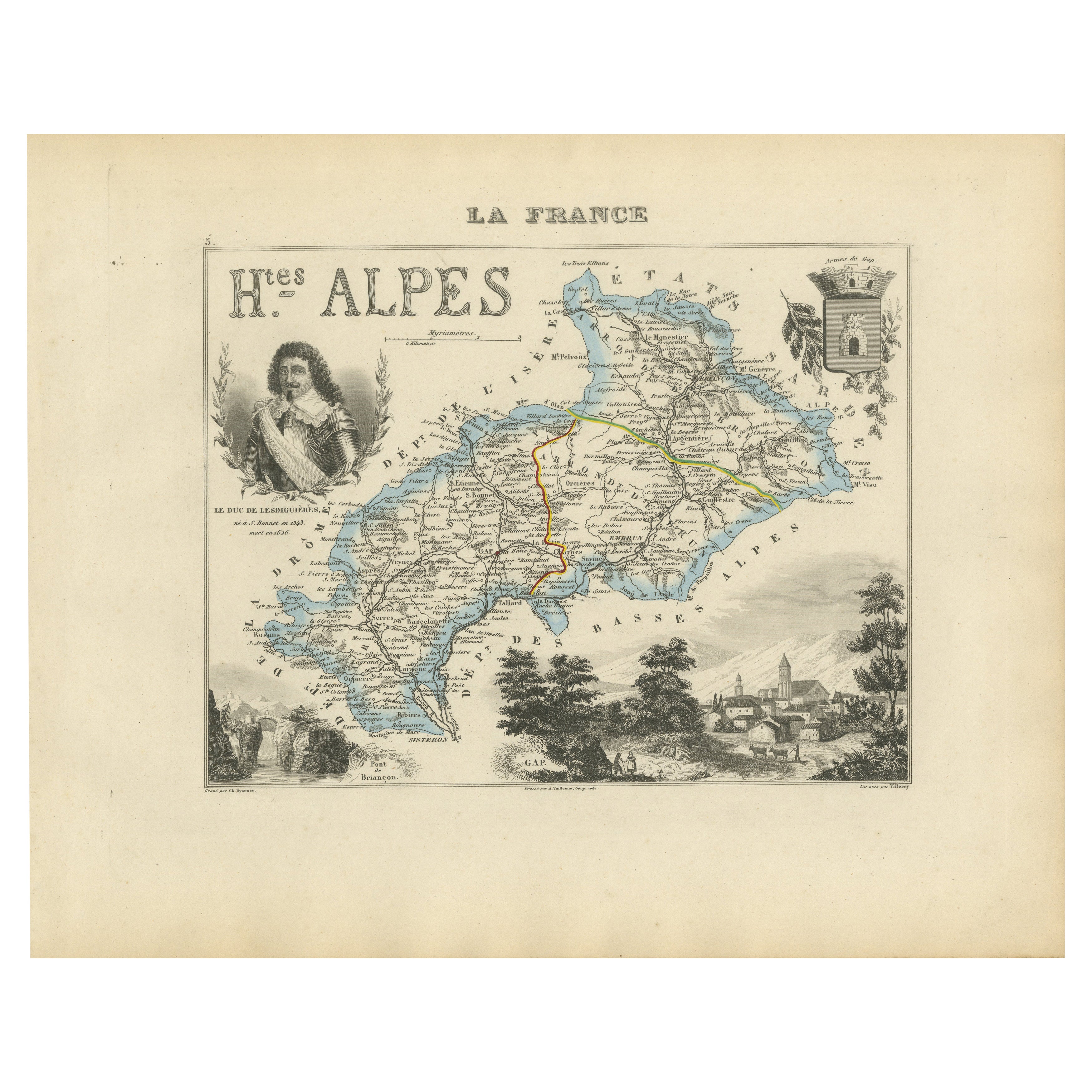
Tout afficherMap of Hautes-Alpes France with Gap and Alpine Scenery by Vuillemin, c.1850
Map of Hautes-Alpes France with Gap and Alpine Scenery by Vuillemin
Description:
This elegant 19th-century map of the Hautes-Alpes department in southeastern France was created by A...
Catégorie
Antiquités, Milieu du XIXe siècle, Français, Cartes
Matériaux
Papier

Map of Ain France with Vineyards of Bugey and Notable Portraits, c.1850
Map of Ain France with Portraits of Bichat and Joubert by Vuillemin, 19th c
This highly decorative 19th-century map of the French department of Ain is taken from the celebrated Nouv...
Catégorie
Antiquités, Milieu du XIXe siècle, Français, Cartes
Matériaux
Papier

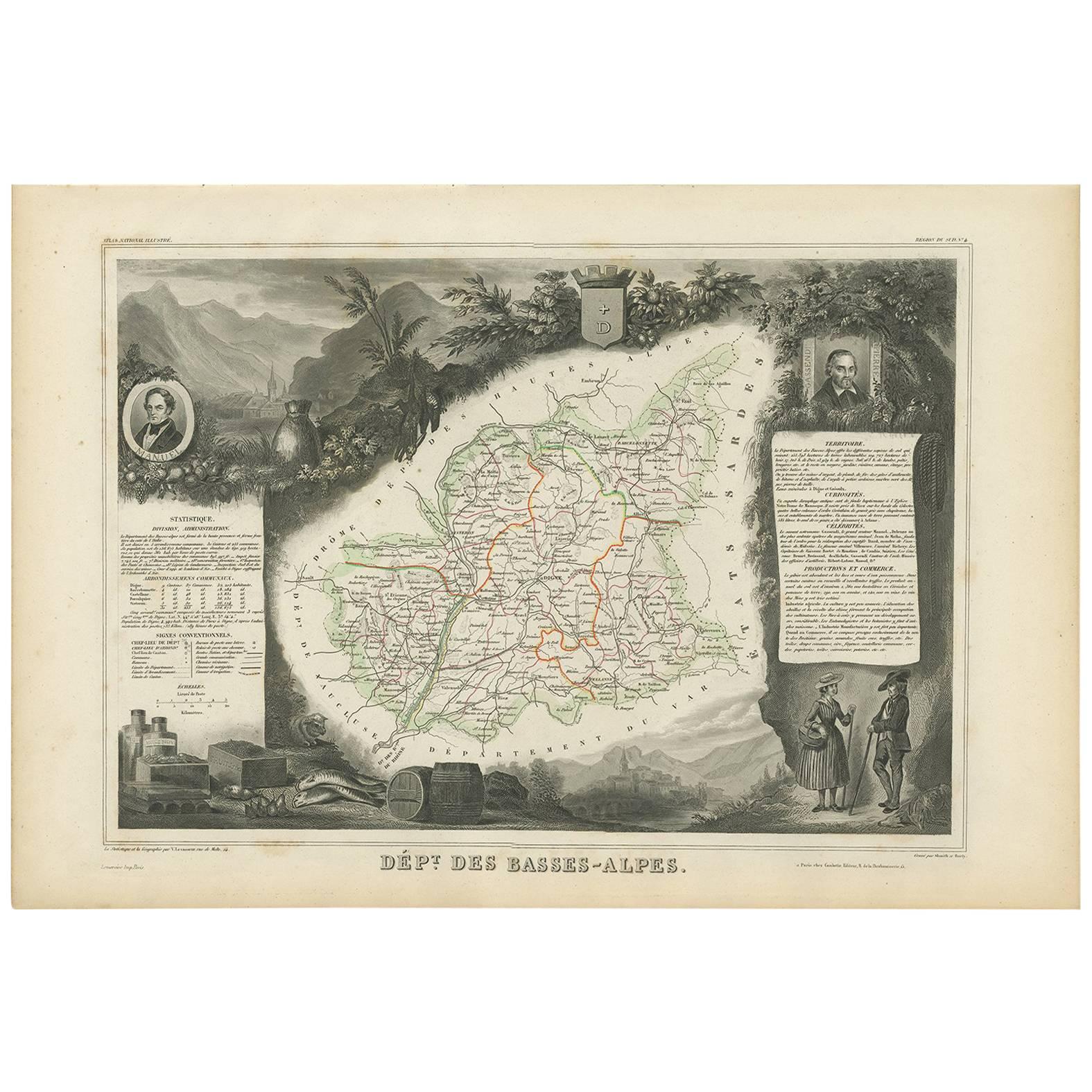
Carte ancienne des Basses-Alpes 'France' par V.I.I., 1854
Par Victor Levasseur
Carte ancienne intitulée "Dépt. des Basses-Alpes". Carte du département français des Basses-Alpes, France. L'ensemble est entouré de gravures décoratives élaborées destinées à illust...
Catégorie
Antiquités, Milieu du XIXe siècle, Cartes
Matériaux
Papier
160 € Prix de vente
20 % de remise
Map of Ariège France with Foix and Pyrenees Landscape by Vuillemin, 19th c
Map of Ariège France with Foix and Pyrenees Landscape by Vuillemin, 19th c
Description:
This beautifully detailed 19th-century map of the Ariège department in southwestern France wa...
Catégorie
Antiquités, Milieu du XIXe siècle, Français, Cartes
Matériaux
Papier

Map of Allier France with Saint-Pourçain Wine Region by Vuillemin, 19th c
Map of Allier France with Saint-Pourçain Wine Region by Vuillemin, 19th c
This decorative 19th-century map of Allier, a central department of France, comes from the celebrated Nouve...
Catégorie
Antiquités, Milieu du XIXe siècle, Français, Cartes
Matériaux
Papier

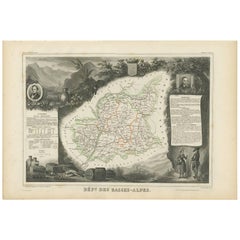
Carte ancienne, colorée à la main, du département des Basses-Alpes, France
Par Victor Levasseur
Carte ancienne intitulée "Dépt. de l'Aube". Carte du département français des Basses-Alpes, France. L'ensemble est entouré de gravures décoratives élaborées destinées à illustrer à l...
Catégorie
Antiquités, Milieu du XIXe siècle, Cartes
Matériaux
Papier
272 € Prix de vente
20 % de remise
Suggestions
Les Hautes Alpes, France. Carte ancienne d'un département français, 1856
Par Victor Levasseur
département des Hautes Alpes", gravure sur acier avec contour original coloré à la main, 1856, tirée de l'Atlas national illustré de Levasseur.
Cette...
Catégorie
XIXe siècle, Naturalisme, Estampes - Paysage
Matériaux
Gravure

Les Hautes Pyrénées, France. Carte ancienne d'un département français, 1856
Par Victor Levasseur
département des Hautes-Pyrénées", gravure sur acier avec contour original coloré à la main, 1856, de l'Atlas national illustré de Levasseur.
Cette région abrite la région viticole ...
Catégorie
XIXe siècle, Naturalisme, Estampes - Paysage
Matériaux
Gravure
Pyrenees Orientales, France. Carte ancienne d'un département français, 1856
Par Victor Levasseur
dept. des Pyrénées Orientales", gravure sur acier avec contour original coloré à la main, 1856, de l'Atlas National Illustre de Levasseur.
Cette région est une région viticole répu...
Catégorie
XIXe siècle, Naturalisme, Estampes - Paysage
Matériaux
Gravure

Carte des Hautes-Pyrnes - Lithographie originale - 19ème siècle
La carte des Hautes-Pyrénées est une lithographie originale réalisée par un graveur anonyme du 19ème siècle.
Imprimé en série de "France Pittoresque" en haut au centre.
L'état de c...
Catégorie
XIXe siècle, Moderne, Estampes - Figuratif
Matériaux
Papier, Lithographie

Fine carte ancienne à l'aquarelle du département des Hautes Alpes de 1856, réalisée à la main par Levasseur's
Nous sommes ravis d'offrir à la vente cette étonnante carte aquarelle de 1856 des Alpes autrichiennes intitulée Dept Des Hautes Alpes tirée de l'Atlas ...
Catégorie
Antiquités, années 1850, Français, Début de l'époque victorienne, Cartes
Matériaux
Papier

Lozere, France. Carte ancienne d'un département français, 1856
Par Victor Levasseur
département de la Lozère, gravure sur acier avec contour original coloré à la main, 1856, de l'Atlas national illustré de Levasseur.
Cette partie montagneuse isolée du Languedoc es...
Catégorie
XIXe siècle, Naturalisme, Estampes - Paysage
Matériaux
Gravure
