Articles similaires à Map of Finistère France with Brest, Quimper and Brittany Coastline, 19th Century


Vous voulez plus d'images ou de vidéos ?
Demander au vendeur plus d'images ou de vidéos
1 sur 10
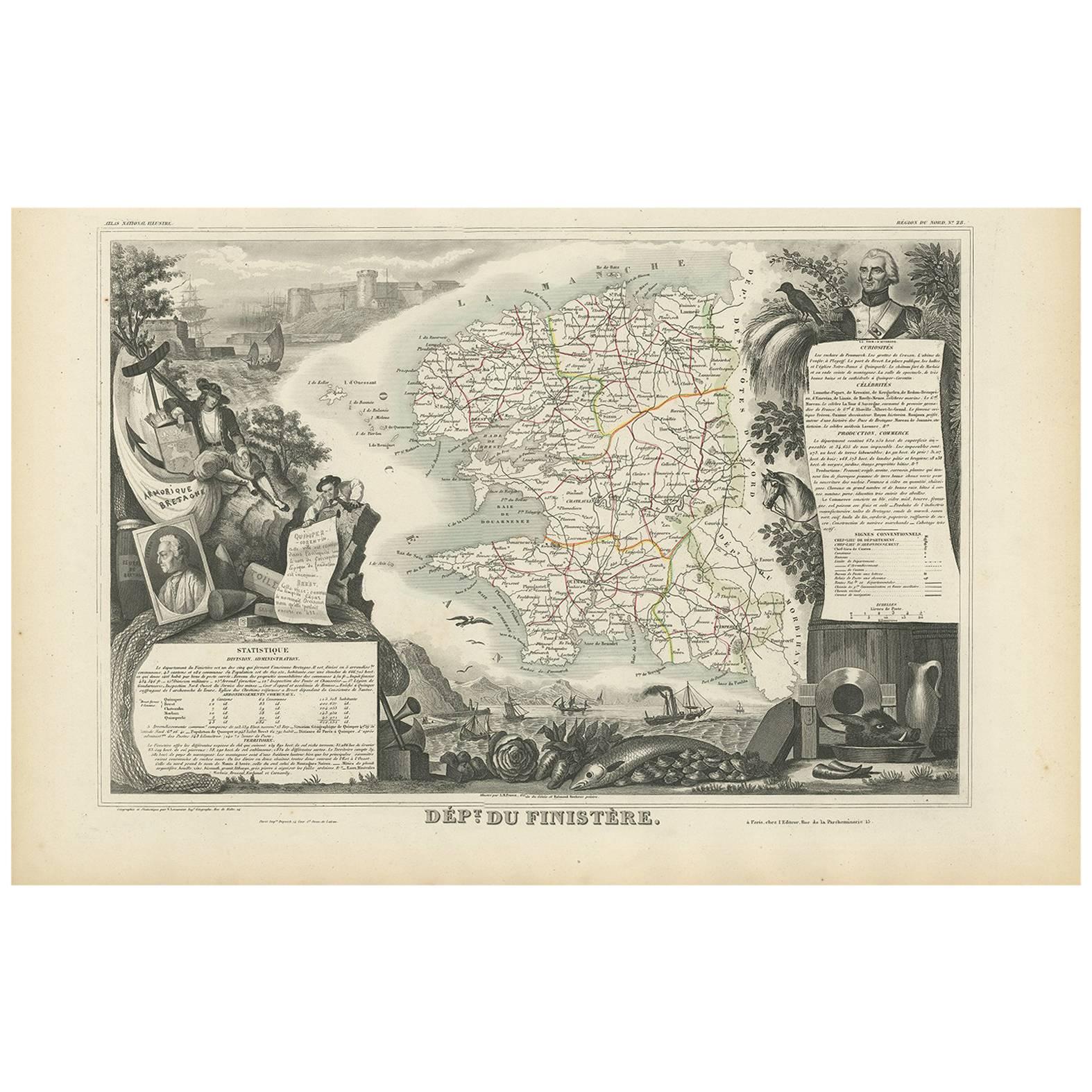
Map of Finistère France with Brest, Quimper and Brittany Coastline, 19th Century
140 €TVA incluse
À propos de cet article
Map of Finistère France with Brest, Quimper and Brittany Coastline, 19th Century
Description:
This richly engraved 19th-century map of Finistère, the westernmost department of mainland France, was drawn by Alexandre Vuillemin and published by Migeon in Paris for the *Nouvel Atlas Illustré*. The map offers a finely detailed view of this culturally distinct and geographically dramatic region, renowned for its rugged coastline, maritime heritage, and Celtic traditions.
Finistère, meaning "end of the land" in Latin, is presented here with its departmental boundaries hand-colored in soft pink. The map clearly delineates towns, roads, rivers, and coastal features, including the Crozon Peninsula and islands such as Ouessant and Sein. Quimper, the prefecture, and Brest, a strategic naval base, are prominently marked along with other key towns like Morlaix, Douarnenez, and Concarneau.
In the lower left corner is an engraved vignette of the harbor at Quimper, depicting a sailing vessel, waterfront buildings, and a view of the Gothic cathedral. On the right stands a full-length statue of a revolutionary figure, General Hoche, who led troops in Brittany during the counter-revolutionary uprisings. The top left features the coat of arms of Finistère, bearing a ship and marine imagery appropriate to this seafaring region.
Finistère forms part of Brittany (Bretagne), a region steeped in Celtic culture, Breton language, and maritime history. While not a major wine-producing area, the department is famous for its cider, seafood (especially oysters and scallops), buckwheat galettes, and dairy products. Its coastal geography and strong winds have made it a critical location for lighthouses, fishing ports, and naval defenses for centuries.
This antique map is both decorative and historically informative, ideal for collectors interested in Brittany, French maritime history, or regional ethnography. It reflects the cultural independence and dramatic geography of France’s far western frontier.
Condition summary:
Very good condition with minor age toning and light foxing near the edges. Engraved lines are crisp and the original hand coloring remains clean and consistent.
Framing tips:
A rustic oak or driftwood frame complements the coastal and Breton character of the map. A cream or light gray mat enhances the engraving and soft pink tones. UV-protective glass is recommended for preservation and clarity.
- Dimensions:Hauteur : 32,5 cm (12,8 po)Largeur : 26,1 cm (10,28 po)Profondeur : 0,2 mm (0,01 po)
- Matériaux et techniques:Papier,Gravé
- Lieu d'origine:
- Période:
- Date de fabrication:circa 1850
- État:Very good condition with minor age toning and light foxing near the edges. Engraved lines are crisp and the original hand coloring remains clean and consistent.
- Adresse du vendeur:Langweer, NL
- Numéro de référence:Vendeur : BG-13331-281stDibs : LU3054345363902
À propos du vendeur
5,0
Vendeur reconnu
Ces vendeurs prestigieux sont des leaders du secteur. Ils représentent le summum en matière de qualité et de design.
Vendeur Platine
Vendeurs premium dont la note est supérieure à 4,7 et le délai de réponse de 24 heures maximum
Établi en 2009
Vendeur 1stDibs depuis 2017
2 567 ventes sur 1stDibs
Temps de réponse habituel : <1 heure
- ExpéditionRecherche du devis...Expédition depuis : Langweer, Pays-Bas
- Politique des retours
Certaines parties de cette page ont été traduites automatiquement. 1stDibs ne garantit pas l'exactitude des traductions. L'anglais est la langue par défaut de ce site web.
Garantie d'authenticité
Bien qu'il soit peu probable que la situation se présente, dans le cas où vous rencontreriez un problème d'authenticité d'un article, contactez-nous dans un délai d'un an pour obtenir un remboursement intégral. DétailsGarantie de remboursement
Si votre article n'est pas conforme à la description, est endommagé pendant le transport ou ne vous est pas livré, contactez-nous sous 7 jours pour obtenir un remboursement intégral. DétailsAnnulation sous 24 heures
Vous disposez d'un délai de 24 heures pour annuler votre achat sans motif.Des vendeurs professionnels agréés
Nos vendeurs de renommée mondiale doivent respecter des normes strictes en matière de service et de qualité, afin de préserver l'intégrité de nos fiches produit.Garantie d'alignement des prix
Si vous constatez qu'un autre vendeur a mis en vente le même article à un prix inférieur sur un autre site, nous nous alignerons sur ce prix.Livraison en toute confiance à l'international
Notre réseau de transporteurs de premier ordre propose des options d'expédition spécialisées dans le monde entier, y compris des livraisons personnalisées.Plus d'articles de ce vendeur
Tout afficherMap of Côtes-du-Nord France with Saint-Brieuc and Brittany Coastline, c.1850
Map of Côtes-du-Nord France with Saint-Brieuc and Brittany Coastline, 19th c
Description:
This elegant 19th-century map of Côtes-du-Nord, the historic name for what is now known as ...
Catégorie
Antiquités, Milieu du XIXe siècle, Français, Cartes
Matériaux
Papier

Carte ancienne de la Finistère « France » par V. Levasseur, 1854
Par Victor Levasseur
Carte ancienne intitulée "Dépt. du Finistère". Carte du département français du Finistère, Bretagne, France. Cette région de France est connue pour sa production de cidre et son exce...
Catégorie
Antiquités, Milieu du XIXe siècle, Cartes
Matériaux
Papier
144 € Prix de vente
20 % de remise
Map of Allier France with Saint-Pourçain Wine Region by Vuillemin, 19th c
Map of Allier France with Saint-Pourçain Wine Region by Vuillemin, 19th c
This decorative 19th-century map of Allier, a central department of France, comes from the celebrated Nouve...
Catégorie
Antiquités, Milieu du XIXe siècle, Français, Cartes
Matériaux
Papier

Carte coloriée à la main du nord-ouest de la France - de la Bretagne à la Loire, 1858
Carte ancienne du Nord-Ouest de la France - Gravure de Stülpnagel, Justus Perthes 1858
Impressionnante carte détaillée du nord-ouest de la France datant du milieu du XIXe siècle, in...
Catégorie
Antiquités, Milieu du XIXe siècle, Allemand, Cartes
Matériaux
Papier
Map of Aisne France with Soissons and Champagne Vineyards by Vuillemin, 19th c
Map of Aisne France with Soissons and Champagne Vineyards by Vuillemin, 19th c
Description:
This richly detailed 19th-century engraved and hand-colored map of the department of Aisn...
Catégorie
Antiquités, Milieu du XIXe siècle, Français, Cartes
Matériaux
Papier

Map of Gard France with Pont du Gard and Wine Regions by Vuillemin, 19th c
Title: Map of Gard France with Pont du Gard and Wine Regions by Vuillemin, 19th c
Description:
This finely engraved 19th-century map of the department of Gard in southern France was...
Catégorie
Antiquités, Milieu du XIXe siècle, Français, Cartes
Matériaux
Papier

Suggestions
Grande carte de France du 19ème siècle
Grande carte de France du 19e siècle.
Remarquable état de conservation, avec une patine d'usage agréable.
Récemment encadré.
France Circa 1874.
Catégorie
Antiquités, Fin du XIXe siècle, Français, Cartes
Matériaux
Lin, Papier

Carte de la France - Gravure - 1820
Carte de France est une Gravure originale réalisée par un artiste inconnu du 19ème siècle en 1820.
Très bon état sur deux feuilles de papier blanc jointes au centre.
La carte est u...
Catégorie
années 1820, Moderne, Estampes - Figuratif
Matériaux
Eau-forte

France, partie nord. Carte de l'Atlas du siècle
L'Atlas du siècle. France, partie nord".
Carte originale ancienne, 1903.
Cartes en médaillon de "La France en provinces" et de "Paris et ses environs".
Pli central tel que publié. ...
Catégorie
Début du 20ème siècle, Victorien, Plus d'Estampes
Matériaux
Lithographie

Indre and Loire, France. Carte ancienne d'un département français, 1856
Par Victor Levasseur
département d'Indre et Loire", gravure sur acier avec contour original coloré à la main, 1856, de l'Atlas national illustré de Levasseur.
Cette région est connue pour sa production...
Catégorie
XIXe siècle, Naturalisme, Estampes - Paysage
Matériaux
Gravure

La Gironde, France. Carte ancienne d'un département français, 1856
Par Victor Levasseur
la Gironde", gravure sur acier avec contour original coloré à la main, 1856, tirée de l'Atlas national illustré de Levasseur.
Ce département côtier est le siège de la région vitico...
Catégorie
XIXe siècle, Naturalisme, Estampes - Paysage
Matériaux
Gravure

Carte de la Vendée - Gravure - 19ème siècle
La carte de la Vendée est une eau-forte réalisée par un graveur anonyme du 19e siècle.
Imprimé en série de "France Pittoresque" en haut au centre.
L'état de conservation de l'œuvre...
Catégorie
XIXe siècle, Moderne, Estampes - Figuratif
Matériaux
Eau-forte
