Articles similaires à Rare carte de 1699 de la colonie écossaise faile de Coloni au Panama


Vous voulez plus d'images ou de vidéos ?
Demander au vendeur plus d'images ou de vidéos
1 sur 10
Rare carte de 1699 de la colonie écossaise faile de Coloni au Panama
580 €TVA incluse
À propos de cet article
Rare 1699 Map of the Failed Scottish Colony of Caledonia in Panama
This scarce and historically fascinating map, titled 'The Scots Settlement in America or New Caledonia A.D. 1699', documents the short-lived and ill-fated Scottish attempt to establish a colony on the Isthmus of Panama. The venture, known as the Darien Scheme, was one of Scotland’s most ambitious colonial enterprises—and ultimately, one of its most disastrous. The map was based on an original drawing by R. M. of the Company of Scotland and captures the strategic geography of the Bay of Caledonia and the surrounding settlements with remarkable clarity.
The engraving shows the narrow isthmus coastline of the Darién province with key geographical features labeled, including Golden Island, Point Look Out, The Inward Bay, and The Outward Bay of Caledonia. Several locations are named in hopeful homage to Scotland’s heritage, such as New Edinburgh, Caledonia, and Mount St. John. In the upper right corner, an inset text describes the location and explains the colony’s intended advantages for trade and its eventual desertion.
The Darien Scheme was launched in 1698 by the Company of Scotland, which hoped to create a trading hub linking the Atlantic and Pacific Oceans. However, plagued by poor planning, disease, lack of supplies, and Spanish hostility, the colony collapsed within a year. The financial losses were devastating and played a pivotal role in Scotland’s decision to join the 1707 Act of Union with England.
This map is a rare and poignant artifact of colonial ambition, Scottish nationalism, and one of the most consequential financial miscalculations in Scottish history.
Condition:
Very good condition considering the age, with clear impressions and light hand coloring. Margins are clean and the sheet has been professionally mounted in a neutral museum mat. There are only minor age-related spots and slight toning, adding to the antique character.
Framing Tips:
This piece is already attractively matted and would suit a dark wood or black frame with a subtle gold bevel to highlight the historic tone. Ideal for collectors of early colonial history, Scottish heritage, or rare Americana.
- Dimensions:Hauteur : 46,4 cm (18,27 po)Largeur : 39,5 cm (15,56 po)Profondeur : 0,2 mm (0,01 po)
- Matériaux et techniques:Papier,Gravé
- Lieu d'origine:
- Période:Fin du XVIIe siècle
- Date de fabrication:1699
- État:Very good condition considering the age, with clear impressions and light hand coloring. Margins are clean and the sheet has been professionally mounted in a neutral museum mat. Folding line as issued.
- Adresse du vendeur:Langweer, NL
- Numéro de référence:Vendeur : BG-140301stDibs : LU3054345435512
À propos du vendeur
5,0
Vendeur reconnu
Ces vendeurs prestigieux sont des leaders du secteur. Ils représentent le summum en matière de qualité et de design.
Vendeur Platine
Vendeurs premium dont la note est supérieure à 4,7 et le délai de réponse de 24 heures maximum
Établi en 2009
Vendeur 1stDibs depuis 2017
2 618 ventes sur 1stDibs
Temps de réponse habituel : <1 heure
- ExpéditionRecherche du devis...Expédition depuis : Langweer, Pays-Bas
- Politique des retours
Certaines parties de cette page ont été traduites automatiquement. 1stDibs ne garantit pas l'exactitude des traductions. L'anglais est la langue par défaut de ce site web.
Garantie d'authenticité
Bien qu'il soit peu probable que la situation se présente, dans le cas où vous rencontreriez un problème d'authenticité d'un article, contactez-nous dans un délai d'un an pour obtenir un remboursement intégral. DétailsGarantie de remboursement
Si votre article n'est pas conforme à la description, est endommagé pendant le transport ou ne vous est pas livré, contactez-nous sous 7 jours pour obtenir un remboursement intégral. DétailsAnnulation sous 24 heures
Vous disposez d'un délai de 24 heures pour annuler votre achat sans motif.Des vendeurs professionnels agréés
Nos vendeurs de renommée mondiale doivent respecter des normes strictes en matière de service et de qualité, afin de préserver l'intégrité de nos fiches produit.Garantie d'alignement des prix
Si vous constatez qu'un autre vendeur a mis en vente le même article à un prix inférieur sur un autre site, nous nous alignerons sur ce prix.Livraison en toute confiance à l'international
Notre réseau de transporteurs de premier ordre propose des options d'expédition spécialisées dans le monde entier, y compris des livraisons personnalisées.Plus d'articles de ce vendeur
Tout afficherCarte ancienne de la Nouvelle-Irlande, 1774
Gravure ancienne intitulée "Neu Irrland (..)". Carte ancienne de la Nouvelle-Irlande avec 7 profils côtiers, Papouasie-Nouvelle-Guinée. Provient de "Geschichte der See-Reisen und Ent...
Catégorie
Antiquités, XVIIIe siècle, Cartes
Matériaux
Papier

232 € Prix de vente
20 % de remise
Carte ancienne d'une baie sur la côte du Chili, Amérique du Sud, vers 1749
Carte ancienne intitulée "Plan van een Baai en Haven aan de Kust van Chili (...) - Plan d'une Baye de la Côte du Chili (...)". Carte originale ancienne d'une baie de la côte chilienn...
Catégorie
Antiquités, XVIIIe siècle, Cartes
Matériaux
Papier

256 € Prix de vente
20 % de remise
Carte ancienne de la baie de Bantam, vers 1720
Rare carte miniature sans titre de la baie de Bantam avec diverses îles dont Pulo Dua et Pulo Batto. Cette carte provient d'un petit récit de voyage et peut provenir d'une édition de...
Catégorie
Antiquités, XVIIIe siècle, Cartes
Matériaux
Papier

48 € Prix de vente
20 % de remise
Carte ancienne de l'île de Coiba, Panama, Amérique du Sud, C.1740
Antique map titled 'Plan de la partie orientale de l'Isle de Quibo'. Map of the eastside of Coiba Island (Quibo), Panama, showing the shoreline around Port de Dames indicating soft s...
Catégorie
Antiquités, XVIIIe siècle, Cartes
Matériaux
Papier

272 € Prix de vente
20 % de remise
Carte ancienne de l'île d'Anjouan par Valentijn, 1726
Par F. Valentijn
Carte ancienne intitulée "Anzuany". Cette carte représente l'île d'Anjouan, une des îles des Comores située entre Madagascar et l'Afrique. La carte est orientée avec le nord à gauche...
Catégorie
Antiquités, Début du XVIIIe siècle, Néerlandais, Cartes

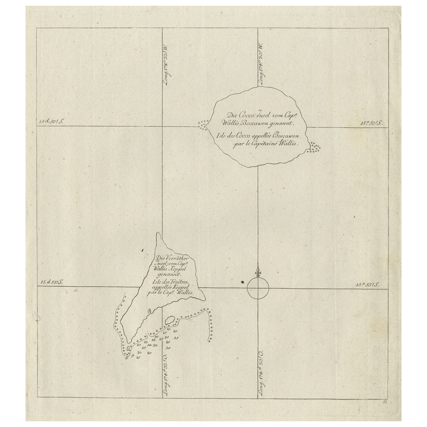
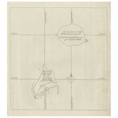
Carte ancienne des îles Cocos ou Keeling, 1778
Carte ancienne intitulée "Die Cocos Insel vom Capt. Wallis Bosawren. Die Verrather Islel von CAP. Wallis Keppel Genannt". Également sous-titrée en français. Ancienne carte des îles C...
Catégorie
Antiquités, XVIIIe siècle, Cartes
Matériaux
Papier
232 € Prix de vente
20 % de remise
Suggestions
Carte ancienne - Zeilan - eau-forte de Johannes Janssonius - années 1650
Par Johannes Janssonius
Carte ancienne - Zeilan est une carte ancienne réalisée en 1650 par Johannes Janssonius (1588-1664).
La carte est une gravure à l'eau-forte coloriée à la main, avec aquarelle au mêm...
Catégorie
années 1650, Moderne, Estampes - Figuratif
Matériaux
Eau-forte

Carte de l'Écosse - eau-forte de Johannes Blaeu - années 1650
La carte de l'Écosse est une carte géographique réalisée par Johannes Blaeu.
Gravure à l'eau-forte, imprimée en 1660 ca.
Gravure sur cuivre, coloriée (coloriage coeval), sur papier...
Catégorie
années 1650, Moderne, Estampes - Figuratif
Matériaux
Eau-forte
375 € Prix de vente
20 % de remise
Carte ancienne - Gallia - Gravure de Johannes Janssonius - années 1650
Par Johannes Janssonius
Carte ancienne - Gallia est une carte ancienne réalisée en 1650 par Johannes Janssonius (1588-1664).
La carte est une gravure à l'eau-forte coloriée à la main, avec aquarelle au mêm...
Catégorie
années 1650, Moderne, Estampes - Figuratif
Matériaux
Eau-forte

Carte de 1627 Hendrik Hondius intitulée "Vltoniae Orientalis Pars", Ric.a009
1627 Carte de Hendrik Hondius intitulée
"Vltoniae orientalis pars,"
Ric.a009
Titre :
Vltoniae orientalis : pars
Titre (alt.) :
Ultoniae orientalis pars
Créateur :
Merca...
Catégorie
Antiquités, 17ème siècle, Néerlandais, Cartes
Matériaux
Papier

1654 Carte de Joan Blaeu représentant le Sutherland, Écosse, intitulée « Southerlandia, »Ric0007
1654 Carte de Joan Blaeu de la
Sutherland, Écosse, intitulé
"Southerlandia".
Coloré à la main
Ric0007
Description :
Belle carte centrée sur Sedan et Doncheri et la Meuze...
Catégorie
Antiquités, 17ème siècle, Néerlandais, Cartes
Matériaux
Papier

Île Rugen, Allemagne : une carte du début du XVIIe siècle par Mercator et Hondius
Par Gerard Mercator
Il s'agit d'une carte du début du XVIIe siècle intitulée "Nova Famigerabilis Insulae Ac Ducatus Rugiae Desciptio". (Carte de l'île de Rugen, en Allemagne) par Gerard Mercator et Hen...
Catégorie
Début du XVIIe siècle, Maîtres anciens, Estampes - Paysage
Matériaux
Gravure
