Articoli simili a 1896 "Territory of Arizona" Map, Published by the General Land Office


Vuoi altre immagini o video?
Richiedi altre immagini o video al venditore
1 di 5
1896 "Territory of Arizona" Map, Published by the General Land Office
Informazioni sull’articolo
Presented is an attractive "Territory of Arizona” map, from the “Report of the Governor of Arizona to the Secretary of the Interior." First published in 1894, this 1896 edition was revised and reconstructed by R. H. Morton and published by the General Land Office, based on “official Records of the General Land Office and other sources under the supervision of Harry King, C.E.” The report gave extensive detail regarding the territory’s population, including Native Americans of Arizona, the agriculture, mining, taxation, banks, transportation, immigration and tourism, as well as the current challenges to the territory’s development. This beautifully colored and highly detailed map was bound in the back of the 142 page Report. The map was lettered by M. Hendges and R.M. Towson.
The map is outlined by county in pink and detailed in black, with town names, roads, wagon roads, railroads, and mountains labeled. Intricate brown hachured mountain areas and the blue waterways combine to provide great visual impact. The map shows the extent of nine Indian reservations, outlined in green, and at least four military reservations, including Fort Apache, colored in solid red. The Grand Canyon is also shown and labeled as a Forest Reserve in pale pink. Any private land claims, confirmed and unconfirmed, are outlined in red, while townships not yet subdivided are identified with a circled cross.
Arizona, formerly part of the Territory of New Mexico, was organized as a separate territory on February 24, 1863. The United States acquired the region under the terms of the 1848 Treaty of Guadalupe Hidalgo and the 1853 Gadsden Purchase.
In the 1870s and 1880s, particularly after the arrival of the railroad in 1880, the population of the Arizona Territory expanded rapidly. With many Native American tribes relocated to reservations, white settlers drawn by the rich agricultural and mineral resources arrived in the region. Gold was discovered in 1863 near the first capital, Prescott. The 1877 discoveries of silver at Tombstone, near Tucson, and copper at Bisbee, also brought many settlers hoping to strike it rich. Many Mormon settlers moved south from Utah and Mexicans emigrated north. The flow of European emigrants also increased markedly thanks to the railroad. By the beginning of the 20th century, the population of the Arizona Territory exceeded 100,000. As the population grew, there was increasing sentiment for statehood, which was finally granted in 1912.
CONDITION:
Very good condition. Lithographed folding map, printed with original color. Map paper is lightly toned, color is strong and attractive. Fold lines, as issued. The map was removed from the original "Report of the Governor of Arizona to the Secretary of the Interior" booklet. Original booklet included. The booklet has red paper covers,142 pages with text and tables describing the territory including immigration, taxation, mining, banks, railroads, and much more. The booklet binding is tight and paper is clean, but the red paper covers have wear and lifting at the spine and a small chip at the right edge on the front cover.
Accompanied by our company's letter of authenticity.
- Dimensioni:Altezza: 73,03 cm (28,75 in)Larghezza: 63,5 cm (25 in)Profondità: 2,54 cm (1 in)
- Materiali e tecniche:
- Periodo:
- Data di produzione:1896
- Condizioni:Aggiunte o modifiche apportate all'originale: Framed according to archival standards by Artem Art Services in Colorado Springs, CO. Usura compatibile con l’età e l’utilizzo.
- Località del venditore:Colorado Springs, CO
- Numero di riferimento:Venditore: M3921stDibs: LU909745349572
Informazioni sul venditore
4,9
Venditore Platino
Venditori Premium con valutazione 4.7+ e tempi di risposta entro 24 ore
Fondazione nel 2010
Venditore 1stDibs dal 2011
452 vendite su 1stDibs
Tempo di risposta standard: 1 ora
- SpedizioneRecupero del preventivo…Spedizione da: Colorado Springs, CO
- Politica di reso
Alcune parti di questa pagina sono state tradotte automaticamente. 1stDibs non può garantire che le traduzioni siano corrette. L’inglese è la lingua predefinita del sito.
Garanzia di autenticità
Nell’improbabile caso in cui si verifichi un problema con l’autenticità di un articolo, contattaci entro un anno per ottenere un rimborso completo. DettagliGaranzia di rimborso
Se il tuo articolo non corrisponde alla descrizione, è danneggiato durante il trasporto o non arriva, contattaci entro 7 giorni per un rimborso completo. DettagliAnnullamento entro 24 ore
Hai un periodo di tolleranza di 24 ore per annullare il tuo acquisto, senza necessità di fornire spiegazioni.Venditori professionali selezionati
I nostri venditori di livello internazionale devono aderire a rigorosi standard di servizio e qualità, garantendo l’integrità delle inserzioni.Garanzia miglior prezzo
Se scopri che un venditore ha pubblicato altrove lo stesso articolo a un prezzo più basso, applicheremo lo stesso prezzo.Consegna globale affidabile
La nostra rete di vettori leader del settore offre opzioni di spedizione specializzate in tutto il mondo, inclusa la consegna personalizzata.Altro da questo venditore
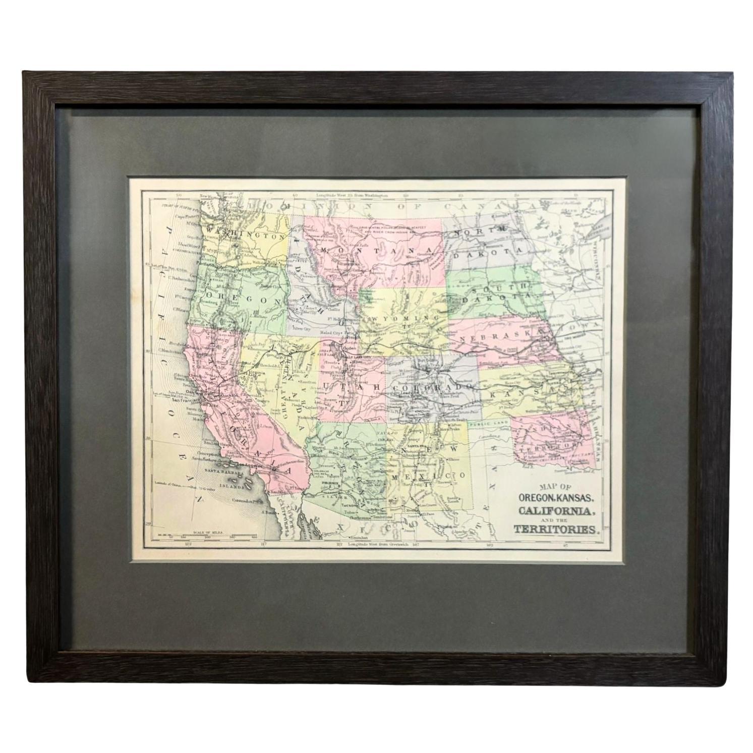
Mostra tutto1890 "Mappa dell'Oregon, del Kansas, della California e dei Territori" di S. A. Mitchell
Di Samuel Augustus Mitchell 1
Viene presentata una mappa del 1890 "Map of Oregon, Kansas, California, and the Territories" di S. A. Mitchell Jr. La mappa è stata pubblicata nell'atlante "Mitchell's New Intermedia...
Categoria
Di antiquariato/d’epoca, Anni 1890, Americano, Vittoriano, Mappe
Materiali
Carta

Mappa della città di Washington del 1840 Pubblicata da William Morrison
Questa mappa, stampata nel 1840, è una rappresentazione dettagliata di Washington, D.C. a metà del XIX secolo. La mappa mostra i numeri degli isolati, le circoscrizioni e gli edifici...
Categoria
Di antiquariato/d’epoca, Anni 1840, Americano, Federale, Mappe
Materiali
Carta

Mappa murale degli Stati Uniti del 1842 di J. H. Young, pubblicata da S. A. Mitchell
Viene presentata una "Mappa degli Stati Uniti" appesa del 1842, incisa da J. H. Young e pubblicata da Samuel Augustus Mitchell, Philadelphia. Si tratta di un bellissimo esemplare del...
Categoria
Di antiquariato/d’epoca, Anni 1840, Americano, Mappe
Materiali
Carta

"Taylor e i suoi generali", prima edizione, pubblicata da E. H. Taylor & Co., 1847
A. Taylor e i suoi generali. New York: H. H. Butler & Co., 1847. Prima edizione. Rilegato in quarto di pelle e tavole in carta marmorizzata. Custodito in una custodia personalizzata....
Categoria
Di antiquariato/d’epoca, Anni 1840, Americano, Libri
Materiali
Carta

1859 "Mappa degli Stati Uniti d'America..." di J.H. Colton
Di J.H. Colton
Viene presentata una "Mappa degli Stati Uniti d'America, delle Province Britanniche, del Messico, delle Indie Occidentali e dell'America Centrale con parte della Nuova Granada e del ...
Categoria
Di antiquariato/d’epoca, Anni 1850, Americano, Mappe
Materiali
Carta

Mappa ornamentale del 1847 degli Stati Uniti e del Messico di H. H. Phelps
Viene offerta una mappa ornamentale originale degli Stati Uniti del 1847 intitolata "Ornamental Map of the United States & Mexico" di Humphrey Phelps. La mappa è stata emessa come at...
Categoria
Di antiquariato/d’epoca, Anni 1840, Americano, Mappe
Materiali
Carta

Ti potrebbe interessare anche
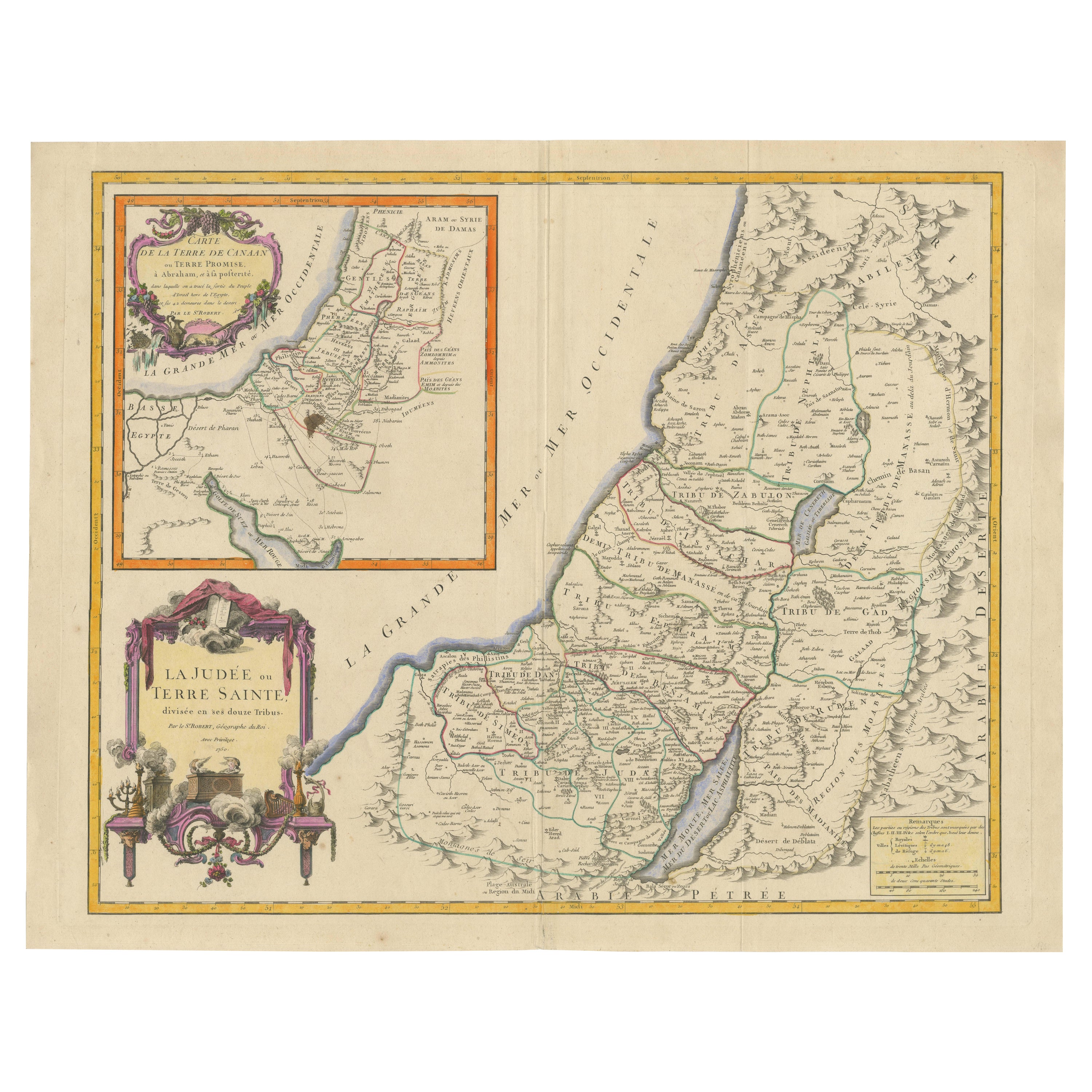
Mappa della Terra Santa del 1750: La Terra di Canaan e le Dodici Tribù
Carta delle Terre di Canaan o Terre Promesse
Cartografo: Le St. Robert
Data di pubblicazione: 1750
Questa splendida mappa del XVIII secolo, "Carte de la Terre de Canaan ou Terre Pro...
Categoria
Di antiquariato/d’epoca, Anni 1750, Mappe
Materiali
Carta
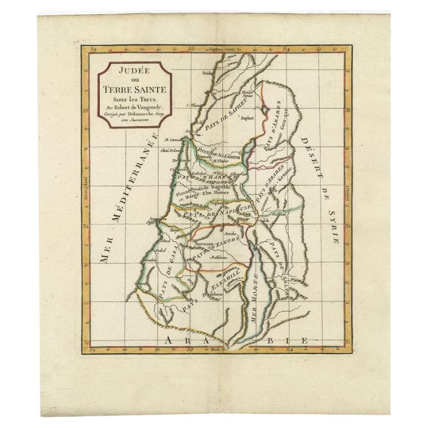
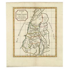
Carta geografica antica della Terra Santa di Delamarche, 1806
Di Charles Francois Delamarche
Mappa antica intitolata "Judee ou Terre Sainte sous les Turcs". Questa mappa mostra la terra santa sotto i turchi. Di Robert de Vaugondy, rivisto e pubblicato da Delamarche. Fonte sc...
Categoria
Di antiquariato/d’epoca, XIX secolo, Mappe
Materiali
Carta
Carta geografica antica della Terra Santa di Schut, 1710
Carta geografica antica della Terra Santa intitolata "Het Beloofde Landt Canaan". Mappa molto dettagliata e decorativa della Terra Santa abbellita da velieri e rosa dei venti. Testo ...
Categoria
Di antiquariato/d’epoca, XVIII secolo, Mappe
Materiali
Carta

390 USD Prezzo promozionale
20% in meno
Carta geografica antica della Terra Santa di Keur, 1748
Carta geografica antica della Terra Santa intitolata "De Gelegentheyd van t'Paradys ende t'Landt Canaan, Mitsgaders d'eerst bewoonde Landen der Patriarchen". Include cinque vignette ...
Categoria
Di antiquariato/d’epoca, XVIII secolo, Mappe
Materiali
Carta

323 USD Prezzo promozionale
20% in meno
Carta geografica antica della Terra Santa di Danckerts, 1710 ca.
Carta geografica antica intitolata "Afbeeldinge van de Veertich-Iaarige Reyse der Kinderen Israëls uyt Egypten door de Roode Zee en de Woestyne tot in 't Beloofde Landt Canaan". Mapp...
Categoria
Di antiquariato/d’epoca, XVIII secolo, Mappe
Materiali
Carta

332 USD Prezzo promozionale
20% in meno
Mappa antica della Terra Santa, 1717 ca.
Carta geografica antica Israel intitolata 'Tabula Geographica Terrae Sanctae'. Rara edizione realizzata sulla base di una mappa della Terra Santa di J. Bonfrerius. La mappa è orienta...
Categoria
Di antiquariato/d’epoca, XVIII secolo, Mappe
Materiali
Carta

362 USD Prezzo promozionale
20% in meno